Warm start to the week with chance of lightning in northern Alberta
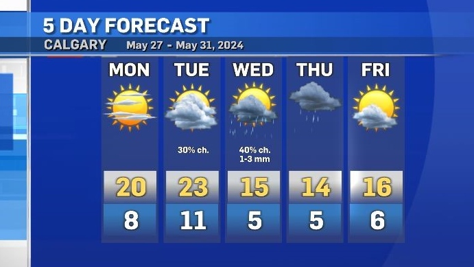
Southern Alberta will start this week with warm and stable conditions, before a pattern breakdown introduces cooler air and instability by the middle of the week when a Pacific trough edges into British Columbia.
In northern Alberta convective activity is possible Monday, especially overnight into Tuesday. More severe thunderstorms are expected along the northern border and into the Northwest Territories before an upper ridge tracks east.
As that upper low establishes itself as the main weather maker for B.C. and Alberta on Tuesday, cooler air coming around the counter-clockwise rotation will impact southern Alberta.
Tuesday night could include some light showers and a quick drop in temperatures as daytime highs settling below seasonal.
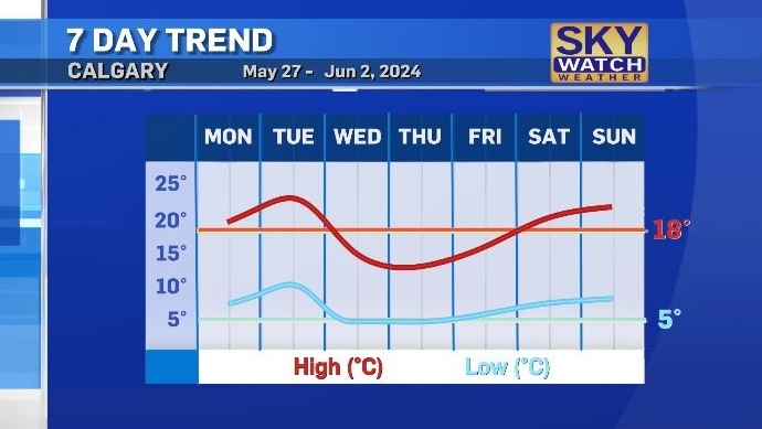
Overnight temperatures will continue to sit consistently outside of the freezing range and warmer weather will return by the weekend.


CTVNews.ca Top Stories

Things a pediatrician would never let their child do
As summer begins for most children around Canada, CTV News spoke with a number of pediatric health professionals about the best practices for raising kids, and how the profession has evolved since the COVID-19 pandemic.
One of Canada's most popular vehicles recalled over transmission issue; 95,000 impacted
One of the country's most popular vehicles is being recalled in Canada due to a transmission issue that may impact tens of thousands of drivers.
Should he stay or should he go now? A look at Trudeau's options after byelection loss
A historic defeat for the Liberals in a downtown Toronto byelection has put a glaring question mark on Prime Minister Justin Trudeau's political future. Here's a look at the options Trudeau and the Liberals face as they enter a summer of soul-searching.
Alabama man denied office after winning election reaches proposed settlement to become town's first Black mayor
An Alabama town and a Black man who was prevented from becoming its mayor after winning his 2020 election have reached a proposed settlement, according to federal court documents.
France bans extreme-right and radical Islamic groups ahead of polarizing elections
France’s government on Wednesday ordered the dissolution of extreme right and radical Muslim groups, four days before the first round of high-stakes legislative elections that may see a surge in support for political extremes.
'Why did I have this surgery?' Ont. mother seeks answers after son's tonsil surgery
An Ontario mother said it looked like a horror movie when she flicked on the lights of her son’s bedroom to find him projectile vomiting blood after his tonsils were removed at McMaster Children’s Hospital.
New experience in Halifax gets people up close and personal to the ocean's most feared predator
Atlantic Shark Expeditions launched a new shark cage experience which gives brave attendees a chance to get up close and personal with the oceans most feared predator.
Workers rescued after swing stage ropes break outside 56th floor of downtown Toronto hotel
Two workers have been rescued after some of the ropes holding up a swing stage atop a soaring downtown Toronto hotel broke.
Many older adults are still taking daily aspirin, even though some shouldn't be, experts say
Some seniors continue to take a daily aspirin in the hopes of reducing their cardiovascular disease risk, even though the practice is only recommended for certain high-risk patients -- and taking it without a doctor's recommendation can come with significant risks.
Shopping Trends
The Shopping Trends team is independent of the journalists at CTV News. We may earn a commission when you use our links to shop. Read about us.


Edmonton
-

Smith tells Trudeau Alberta will opt out of federal dental plan
Alberta is opting out of the federal dental plan, the premier told the Canadian government late Tuesday afternoon.
-
Police investigating at 82 Avenue apartment building
Police taped off the entrance to an apartment building east of Whyte Avenue early Wednesday morning.
-
Pride of the Prairies k.d. lang to join Canadian Country Music Hall of Fame
Alberta singer-songwriter k.d. lang is this year's inductee into the Canadian Country Music Hall Of Fame.
Lethbridge
-

Coutts murder-conspiracy trial to see more video of accused talking with police
The trial of two men charged with conspiracy to commit murder at the border blockade at Coutts, Alta., is expected to hear more from one of the accused in a video statement he gave to police.
-
Lethbridge College to be redesignated as polytechnic institution
Lethbridge College will soon become Alberta's latest polytechnic.
-
Town mulling options as Milk River dries up
Before the St. Mary siphon burst, the Milk River's flow rate was approximately 17 and a half cubic metres per second. Monday, it was less than one cubic metre per second.
Vancouver
-

'No fun city': Calls to extend hours at Vancouver beaches
Some Vancouver residents want hours to be extended at city beaches during the summer, criticizing the current bylaw and questioning its enforcement.
-
Transit police campaign targets drivers in Vancouver bus lanes
In a targeted campaign aimed at keeping bus lanes clear for transit vehicles, Metro Vancouver Transit Police have ticketed close to three hundred drivers so far this week.
-
Water quality advisory issued at Sunset Beach
Officials are warning people not to swim or wade at Vancouver’s Sunset Beach due to high bacteria levels in the water.
Vancouver Island
-

Critically endangered Vancouver Island marmots released into the wild
Volunteers carried cages containing very rare furry creatures up Mount Washington on Monday as part of the mission to save Canada’s most endangered mammal.
-
Meet the centenarians: Canada's oldest age group is also its fastest-growing
Vi Roden said she reads an average of 50 books a year, attends history lectures at her local seniors centre, and does yoga twice a week.
-
Pembina, B.C. First Nation give green light to multibillion-dollar LNG project
Pembina Pipeline Corp. and the Haisla First Nation say they have made a final investment decision that will see them go ahead with their proposed US$4-billion Cedar LNG project off the B.C. coast.
Saskatoon
-

'The federal government can't interfere': Sask. will not comply with federal clean electricity regulations
The Government of Saskatchewan announced that it will not comply with the incoming federal clean electricity regulations.
-
Judge rejects Saskatoon mayoral candidate's lawsuit to halt housing accelerator changes
A judge has rejected a Saskatoon mayoral candidate’s bid for a court injunction on zoning changes required for the city to access federal housing accelerator funds.
-
Sask. town gets help from province after destructive weekend storm
The Saskatchewan Public Safety Agency (SPSA) has stepped up to help Carrot River after a destructive storm tore through the community on Sunday evening.
Regina
-

Court hears from victim and mother at trial for Regina teacher accused of sexually exploiting student
High emotions filled a Regina courtroom on the second day of a trial for a former Regina teacher accused of sexually exploiting a female student.
-
Trio from Carnduff, Sask. arrested after drugs, sword seized in traffic stop
A proactive patrol by RCMP officers led to a collection of drug trafficking weapon related charges for three people from Carnduff, Sask.
-
'The federal government can't interfere': Sask. will not comply with federal clean electricity regulations
The Government of Saskatchewan announced that it will not comply with the incoming federal clean electricity regulations.
Toronto
-

'Why did I have this surgery?' Ont. mother seeks answers after son's tonsil surgery
An Ontario mother said it looked like a horror movie when she flicked on the lights of her son’s bedroom to find him projectile vomiting blood after his tonsils were removed at McMaster Children’s Hospital.
-
Unidentified human remains found inside tent in downtown Toronto, police say
Toronto police are seeking the public’s assistance identifying a woman’s human remains found inside a tent in downtown Toronto.
-
Was a Toronto byelection a wake-up call on Trudeau's approach to antisemitism?
An organizer who encouraged Jewish residents to vote against the Liberals in this week's Toronto byelection suggests a rise in antisemitism motivated many to show up at the polls.
Montreal
-

Here are the 10 most dangerous intersections for Montreal cyclists
Researchers out of McGill University say there is a critical need for safer cycling infrastructure around certain intersections in Montreal after pinpointing 10 troubling spots in a recent survey.
-
Teen driver, passenger in hospital after crash in Montreal's West Island
Two people are in hospital, including a teenage driver, after a crash on Highway 20 in Beaconsfield in Montreal's West Island.
-
Teen dies after being hit riding e-scooter in Montreal
The 14-year-old boy who was hit by a car in Montreal on Monday has succumbed to his injuries.
Atlantic
-

Emergency alert issued in Lunenburg County cancelled after 'dangerous man' arrested: N.S. RCMP
The Nova Scotia RCMP has arrested a man in connection with an emergency alert issued in Lunenburg County Wednesday morning.
-
New experience in Halifax gets people up close and personal to the ocean's most feared predator
Atlantic Shark Expeditions launched a new shark cage experience which gives brave attendees a chance to get up close and personal with the oceans most feared predator.
-
Things a pediatrician would never let their child do
As summer begins for most children around Canada, CTV News spoke with a number of pediatric health professionals about the best practices for raising kids, and how the profession has evolved since the COVID-19 pandemic.
Winnipeg
-

Ray St. Germain dead at 83
A well-known Metis musician has died after a years-long battle with Parkinson’s disease.
-
True North asking for extension on decision to purchase Portage Place
The potential purchaser of Portage Place Mall is asking for a 90-day extension for its decision as to whether or not it will buy and redevelop the space.
-
RCMP, Manitoba Crown to update Carberry bus crash investigation Wednesday
Manitoba RCMP and the province’s Crown prosecution service will provide an update on the investigation into a deadly bus crash near Carberry, Man. one year ago.
Ottawa
-

Vehicle driven into a home in Ottawa's west end
There were no reports of injuries after a car crashed into a home in Kanata, the fourth time a vehicle has been driven into a home in Ottawa in June.
-
Here's a look at the Ottawa Senators new jersey for next season
The National Hockey League and Fanatics released images of the Fanatics Authentic Pro NHL on-ice uniforms for the Senators and all NHL clubs Wednesday morning.
-
Royal Canadian Air Force to hold practice flypast over Ottawa on Wednesday ahead of Canada Day
The Royal Canadian Air Force (RCAF) will hold a flypast over downtown Ottawa and LeBreton Flats on Wednesday, as part of preparations for Canada Day. Aircraft are scheduled to fly over Ottawa between 12 p.m. and 3 p.m.
Northern Ontario
-

One of Canada's most popular vehicles recalled over transmission issue; 95,000 impacted
One of the country's most popular vehicles is being recalled in Canada due to a transmission issue that may impact tens of thousands of drivers.
-
Things a pediatrician would never let their child do
As summer begins for most children around Canada, CTV News spoke with a number of pediatric health professionals about the best practices for raising kids, and how the profession has evolved since the COVID-19 pandemic.
-
Indigenous burial grounds in northern Ont. to be protected
Ancient burial grounds in the Town of Blind River will soon be marked, and blocked off to the public.
Barrie
-

$600K worth of stolen goods retrieved during Huron-Perth bust
One man has been charged with possession of a stash of stolen goods and machinery.
-
Barrie celebrates Canada Day with pop-up parties
Barrie's Canada Day On The Move celebrations share the fun downtown, as well as in three city parks.
-
Former Barrie Colts captain Aaron Ekblad is a Stanley Cup Champion
Barrie's former captain of the Barrie Colts hoists the Stanley Cup after Game 7.
Kitchener
-

University of Waterloo takes legal action to remove Occupy UW encampment
An ongoing dispute between the University of Waterloo and a pro-Palestinian encampment has turned into a legal battle.
-
Two Southwestern Ontario players are now Stanley Cup champions
The Florida Panthers have made NHL history and two of their players, who call Southwestern Ontario home, are now celebrating their first big Stanley Cup win.
-
Kitchener family advocates for new integrated crisis centre after losing daughter to suicide
Mike and Fiona Roth lost their daughter, Kaitlyn, to suicide – just days before her 21st birthday – after they say they were on a two-year waitlist for mental health support.
London
-

Vast majority of London’s parkland now off limits to homeless encampments
Londoners experiencing homelessness must now navigate a more complex and restrictive set of rules about where they can set up a tent or make-shift shelter.
-
Trees topple in some London neighbourhoods after brief storm blows through
CTV London Meteorologist Julie Atchison said sunshine will start your Tuesday, 'A nice mix of sun and cloud, winds picking up out of the south as we head into the afternoon.'
-
Council rebuffs Farhi Holdings’ land deal and confirms plan to build new city hall on current property
A last ditch effort to investigate constructing a new city hall building in the heart of downtown London was shot down by a majority of city council.
Windsor
-
School board meeting shut down, police called over disruptions
A special meeting of the Greater Essex County District School Board (GECDSB) was dissolved after numerous disruptions from members of the public.
-
Video appears to show vehicle T-boned by school bus at red light
Three students were on a school bus that allegedly ran a red light, colliding with an SUV passing through an intersection on June 19.
-
Five-year extension for transit service to Amherstberg
Amherstburg council will be agreeing to another five years of Transit Windsor route 605 — carrying passengers to and from town.


