Rainfall warnings issued for southern Alberta ahead of multi-day event

Another round of moisture is heading into southern Alberta with some areas east of the QEII and Highway 2 expecting significant accumulations in less than two days.
An inverted trough that starts in Colorado will direct rain as far north as central and northern Alberta starting Monday and lasting until early Wednesday.

In anticipation of the persistent rain and the multi-day event, Environment and Climate Change Canada issued rainfall warnings for southeastern Alberta.
The agency noted the bulk of the rain is expected Monday night and Tuesday and that rainfall totals will be variable.
“Widespread rainfall totals of 50 to 70 mm are likely. Locally higher amounts of 80 mm or more are possible.”
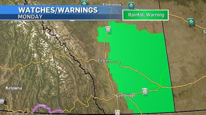
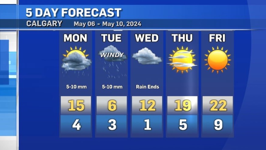
Calgary is expecting between 10 to 20 milimetres of rain, however the upsloping nature of this system could mean those totals are higher.
There is the potential brief thunderstorms will develop as the warmer air in southern Alberta clashes with the incoming system, and strong winds may prompt wind warnings in some of the areas currently under rainfall warnings.
As temperatures drop Tuesday areas closer to the foothills and in the mountains could see precipitation fall as mixed precipitation and/or snow.
The daytime high in Calgary Tuesday will be 9 degrees below seasonal.
Conditions will improve throughout the day Wednesday with daytime highs reaching 19 C Thursday and edging into the low 20s by the weekend.
The average daytime high in Calgary is 15C.


CTVNews.ca Top Stories

Signs of Alzheimer’s were everywhere. Then his brain improved
Blood biomarkers of telltale signs of early Alzheimer’s disease in the brain of his patient, 55-year-old entrepreneur Simon Nicholls, had all but disappeared in a mere 14 months.
Box tree moths have infested Ontario and experts say more are coming. Here's what to do to protect your garden
An invasive moth species is on the rise in Canada and, if you've planted a certain shrub, it could stand to ruin your garden.
Lyon-bound Air Canada Boeing 787-8 Dreamliner from Montreal turns back midflight due to pressurization alert
Passengers heading from Montreal to Lyon, France on Friday were forced to return home and depart the next day after a pressurization indication was detected in flight.
Oilers dominate Canucks, win to force deciding Game 7
The Edmonton Oilers avoided elimination from the NHL playoffs Saturday night, beating the visiting Vancouver Canucks 5-1 in Game 6 of their second-round series.
The eight most expensive homes for sale in Ottawa this spring
Ottawa's ultra luxury housing market is blooming like the tulips this spring, with a significant increase in the number of homes sold worth more than $2 million.
B.C. pipeline company argues its 'haulers' are not trucks, for tax purposes
A contractor working on the Coastal GasLink pipeline has been denied more than $333,000 worth of tax rebates because pieces of machinery it purchased – and claimed were not trucks – were deemed sufficiently truck-like in B.C. Supreme Court.
$500K-worth of elvers seized at Toronto airport
Fishery and border service officers seized more than 100 kilograms of unauthorized elvers at the Toronto Pearson International Airport on Wednesday.
Usyk beats Fury by split decision, becomes undisputed heavyweight champion
Oleksandr Usyk defeated Tyson Fury by split decision to become the first undisputed heavyweight boxing champion in 24 years.
To plant or not to plant? Gardening tips for May long weekend
May long weekend is finally here, and with the extra time off you may be getting the itch to head out to your garden and plant. However, the old debate whether you should plant now, or wait, is still ever-present.
Shopping Trends
The Shopping Trends team is independent of the journalists at CTV News. We may earn a commission when you use our links to shop. Read about us.


Edmonton
-

Oilers dominate Canucks, win to force deciding Game 7
The Edmonton Oilers avoided elimination from the NHL playoffs Saturday night, beating the visiting Vancouver Canucks 5-1 in Game 6 of their second-round series.
-
Woman slashes attacker with seatbelt cutter in Edmonton road rage incident Friday: EPS
Police are looking for three people after a road rage incident in south Edmonton on Friday morning.
-
Evacuation orders lifted in Fort McMurray Saturday as rain dampens wildfire activity
Residents of Fort of McMurray who were displaced over wildfire concerns were told to return home Saturday.
Lethbridge
-

Lethbridge home prices continue to rise
The average home price in Lethbridge has jumped 11.6 per cent in the last year. A home in Lethbridge now costs just over $374,000 on average. That's according to the latest data from the Alberta Real Estate Association.
-
Downtown Lethbridge lawlessness task force seeing positive progress
Lethbridge has been working to address lawlessness in the city’s downtown over the past six months.
-
Patios and parklets program returns to downtown Lethbridge for 2024
It's just about patio season in Lethbridge, and the city is once again rolling out its annual patios and parklets program.
Vancouver
-

Canucks lose to Oilers 5-1, series headed to Game 7
The Vancouver Canucks lost to the Edmonton Oilers Saturday night, forcing the second-round series to go to Game 7.
-
B.C. pipeline company argues its 'haulers' are not trucks, for tax purposes
A contractor working on the Coastal GasLink pipeline has been denied more than $333,000 worth of tax rebates because pieces of machinery it purchased – and claimed were not trucks – were deemed sufficiently truck-like in B.C. Supreme Court.
-
Free Vancouver Comic Arts Festival draws artists from around the world
Hundreds of independent comics artists, writers and enthusiasts made their way to Yaletown Saturday for the 12th edition of VanCAF – the Vancouver Comic Arts Festival.
Vancouver Island
-

Doctors, patients want options to reduce dialysis waste adding to climate change
Dr. Caroline Stigant, a nephrologist at Royal Jubilee Hospital in Victoria and a leading advocate for sustainable kidney care, said each hemodialysis treatment uses up to 500 litres of water and large amounts of energy.
-
Police remain tight-lipped one year after crash killed municipal worker near Victoria
One year after an allegedly reckless driver careened into a municipal park east of Victoria, killing a 52-year-old husband and father of two young children, there are few answers about what led to the crash and no criminal charges have been forwarded to prosecutors.
-
'It's pure joy!': B.C. pilot takes 96-year-old grandma on meaningful flight
“Good to see you,” Ryan Godard says before giving his 96-year-old grandma a big hug and walking her towards the small airplane. “Let’s get you prepped.”
Saskatoon
-

Saskatchewan Roughriders visit Saskatoon for Green and White day
Hundreds of Saskatoon's football fans gathered at Saskatoon Minor Football (SMF) field Saturday to experience the Saskatchewan Roughriders pre-season ahead of their home opener.
-
'The car was half inside my children's room': Car crashes into Saskatoon apartment building
Firefighters responded to a scene on the 300 Block of Herold Road Friday morning after a car collided with an apartment building.
-
Firefighters on scene of structure blaze in Saskatoon
Firefighters are on the scene of a structure blaze in the 100 Block Avenue Q South.
Regina
-

Bear spotted in Lumsden euthanized after risk to public safety: Sask. RCMP
A young bear that had made its way into Lumsden, Sask. was killed by Saskatchewan RCMP officers after unsuccessful efforts to trap it.
-
Willy the Winmar mascot celebrated in Moose Jaw
Winmar celebrated their mascot, Willy’s third birthday on Sunday in Moose Jaw.
-
Former Royal Regina Rifle troop member honoured with official headstone marking
Family members and military officials gathered Friday in Swift Current for one final salute to a former Royal Regina Rifle troop member.
Toronto
-

Small plane crashes just outside Toronto
A small plane crashed with two people onboard northeast of Toronto on Saturday morning.
-
Man fatally shot in car outside house in Brampton
A man was fatally shot in a car outside of a house in Brampton Saturday morning, police say.
-
Police release photo of suspect who allegedly smashed windows, doors of North York synagogue
Toronto police have released a photo of an individual suspected of smashing windows and glass doors of a North York synagogue on Friday, which is being investigated as a hate-motivated incident.
Montreal
-

Montreal businessman writes scathing letter to government to care for homeless population
A Montreal real estate owner is calling on all levels of government to address the growing number of homeless people in the city, and he's written a letter to all levels of government to do something.
-
Online obituary business from Quebec City catching flak for posting unauthorized death notices
Some within the funeral home and mortuary services industries in Quebec say they are frustrated with an online obituary site that publishes death notices from public information posted on the internet. They claim the site is doing so without consent from the families.
-
CTV News Montreal at 6 o'clock for Saturday, May 18, 2024
CTV News Montreal at Six for Saturday, May 18, 2024 with anchor Angela MacKenzie.
Atlantic
-

'You can really start to feel the excitement': Unofficial start to summer kicks off in the Maritimes
Maritimers and tourists are gearing up for the unofficial start to summer as the May Long Weekend gets underway.
-
Celebration of life for Arthur Irving held in Saint John
Friends and family of Arthur Irving gathered in his Saint John home Saturday to celebrate his life after the businesses titan passed away Monday at the age of 93.
-
Road closures in Halifax for Saturday’s Blue Nose Marathon events
With events for the Blue Nose Marathon beginning on Saturday, Halifax Regional Police has issued warnings for drivers of many roads that will be closed for the day.
Winnipeg
-

WFPS deals with a pair of structure fires and a gas leak to start May long weekend
Winnipeg fire crews had to deal with multiple fires and a gas leak between Friday night and Saturday morning.
-
'They can start walking': Robotics company helping children with mobility issues take steps forward
A Canadian tech company is helping kids with mobility issues put their best foot forward with the help of a pair of revolutionary robotic legs.
-
To plant or not to plant? Gardening tips for May long weekend
May long weekend is finally here, and with the extra time off you may be getting the itch to head out to your garden and plant. However, the old debate whether you should plant now, or wait, is still ever-present.
Ottawa
-

Ottawa woman says she no longer feels safe after hijab pulled at Israel flag raising
The Ottawa Police Service says its hate crime unit is investigating a reported hijab-pulling incident at a flag-raising ceremony for Israel’s Independence Day in front of city hall earlier this week.
-
What's happening in Ottawa this weekend: May 17-20
CTVNewsOttawa.ca looks at things to do in Ottawa during the Victoria Day long weekend.
-
What's open and closed in Ottawa over the Victoria Day long weekend
CTVNewsOttawa.ca looks at what's open and closed in Ottawa over the Victoria Day long weekend.
Northern Ontario
-

Woman with liver failure rejected for a transplant after medical review highlights alcohol use
For nearly three months, Amanda Huska has been in an Ontario hospital, part of it on life support, because of severe liver failure. Her history of alcohol use is getting in the way of her only potential treatment: a liver transplant.
-
Northern Ont. man jailed 10 days for fishing violations
A Sault Ste. Marie man has been jailed for 10 days for failing to comply with a court order banning him from fishing.
-
Conservatives, NDP should be 'celebrating' EV deals: industry minister
Industry Minister François-Philippe Champagne says federal opposition parties should be 'celebrating' the recently announced electric vehicle deals, despite their criticisms the Liberals refuse to make public the terms and conditions laid out in the contracts.
Barrie
-

SIU investigating death of 28-year-old woman
The Special Investigations Unit is investigating the circumstances surrounding the death of a 28-year-old woman in Midland on Saturday.
-
Firefighters battle large fire in Barrie
Firefighters battled a large building fire in Barrie on Saturday.
-
OPP investigating crash in Minden Hills
OPP is investigating a crash that happened in Minden Hills on Saturday.
Kitchener
-

Three people injured in robbery at Fairview Park Mall: police
A police investigation is underway after a jewellery store at Fairview Park Mall in Kitchener was robbed.
-
Impaired driver sentenced to 7 years after double-fatal Cambridge crash
A man who killed two people in a drunk driving crash was sentenced Friday to seven years behind bars.
-
Event in New Hamburg Ont. trains dogs to detect human remains
A farm in New Hamburg became the training grounds for the event teaching dogs and their owners advanced tracking and detection skills.
London
-

London Knights celebrate OHL Championship with hundreds of fans at Budweiser Gardens
There was no place London Knights fans would rather be on a sunny day than indoors celebrating with their favourite hockey club.
-
Serious injuries sustained in crash near Listowel
Perth County OPP responded to a report of a motor vehicle collision in the Municipality of North Perth late Friday afternoon.
-
Small plane crashes just outside Toronto
A small plane crashed with two people onboard northeast of Toronto on Saturday morning.
Windsor
-
 VIDEO
VIDEOVIDEO Born without front legs, this dog has been inspiring the world for 3 years: Dresden farm owner
A sanctuary dedicated to animals with disabilities is celebrating the third birthday of one of its most popular residents.
-
Pro-Palestinian protestor laments UWindsor president's absence from recent meeting amid ongoing campus encampment
Protestors who have set up an encampment on the University of Windsor campus say the school's president was absent from a recent meeting with school administration.
-
Small plane crashes just outside Toronto
A small plane crashed with two people onboard northeast of Toronto on Saturday morning.


