Seasonal start to the weekend ahead of warmup early next week
Temperatures in and around Calgary were in the low double-digits to kick off Friday with wind chill values making it feel as cold as -19 in some locations.
The daytime high is forecast to reach -1 C by Friday afternoon, which is just shy of seasonal.
A ridge of high pressure west of British Columbia will push in toward the coastline Saturday, bring precipitation.
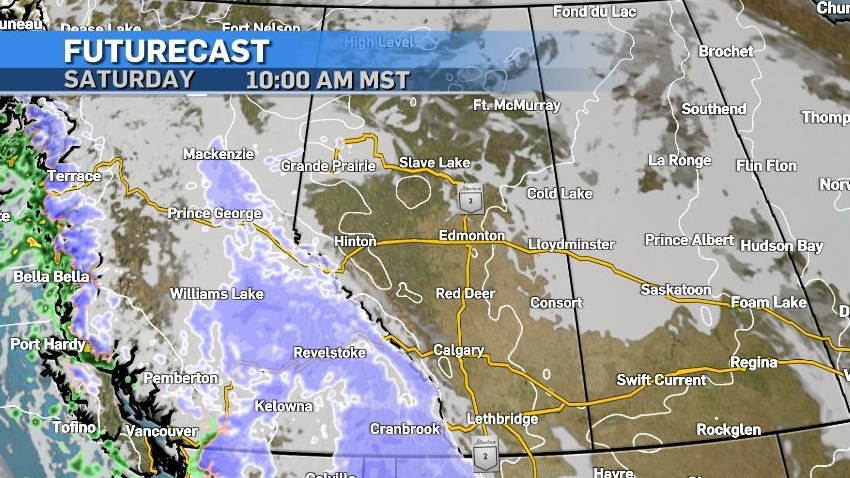
Due to the temperatures being warmer over the water and along the west coast, the initial presentation will be rain.
This is likely to transition to snow as this ridge tracks east through the B.C. interior.
Most of that precipitation will stay on the west side of the Rockies, and folks in southern Alberta can expect chinook-like conditions with stronger winds in the southwest corner of the province.
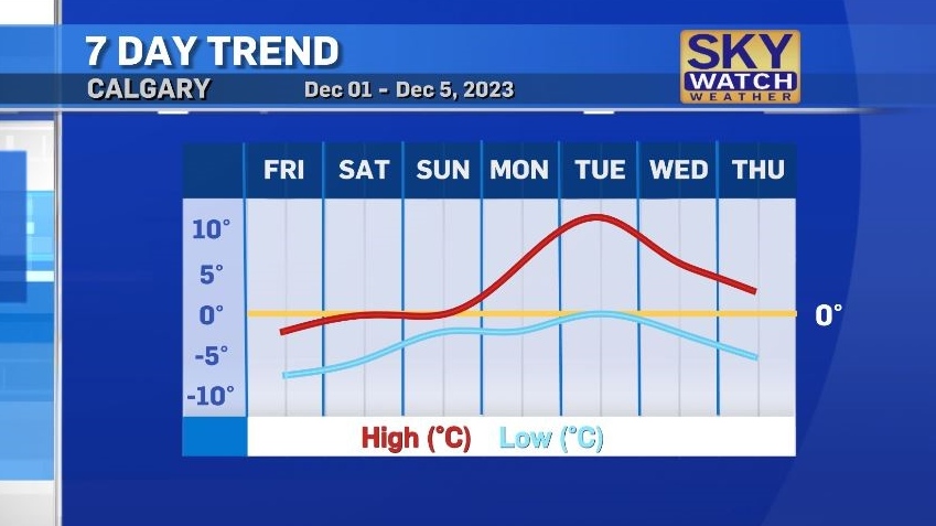
This shift will elevate temperatures in Calgary, so that by Sunday the overnight lows will be closer to the average daytime highs for the start of December, and by Tuesday the high might reach 11 C.


CTVNews.ca Top Stories

Canadian Olympic Committee CEO says soccer coach Bev Priestman likely aware of spying
Canadian Olympic Committee chief executive officer David Shoemaker says the head coach of the national women's soccer team was likely aware drones were used to spy on another team's practices in France.
DEVELOPING
DEVELOPING Recent rain, cooler weather limiting spread of wildfires in Jasper National Park
Cool and wet weather is making a difference in Jasper National Park.
Canada to bring home fewest Olympic medals since 2012, according to forecaster
Fewer Canadians are expected to reach the Paris podium than in the previous two Olympic Summer Games, a global data analytics company predicts.
Harris pushes Netanyahu to ease suffering in Gaza: 'I will not be silent'
U.S. Vice President Kamala Harris pressured Israeli Prime Minister Benjamin Netanyahu on Thursday to help reach a Gaza ceasefire deal that would ease the suffering of Palestinian civilians, striking a tougher tone than President Joe Biden.
Mary-Ellen Turpel-Lafond likely has Indigenous DNA: report
The Law Society of British Columbia says a DNA test shows a former judge and Order of Canada recipient accused of falsely claiming to be Cree "most likely" has Indigenous heritage.
Yukon woman narrowly escapes bear attack, credits hair clip
A woman in Yukon believes her hair clip helped save her during a bear attack.
Prince William's 2023 salary revealed in new report
Newly released financial reports show that William, the Prince of Wales, drew a salary of $42.1 million last fiscal year, his first since inheriting the vast and lucrative Duchy of Cornwall.
'I was just shocked': Jasper lodge owner on seeing property destroyed by wildfire
On Wednesday night, the owner of Maligne Lodge in Jasper, Alta., was shocked to receive a photo of her business engulfed in flames.
U.S. authorities have arrested 'El Mayo' Zambada, a historic leader of Mexico's Sinaloa cartel
Ismael 'El Mayo' Zambada, a historic leader of Mexico's Sinaloa cartel, and Joaquin Guzman Lopez, a son of another infamous cartel leader, were arrested by U.S. authorities in Texas on Thursday, the U.S. Justice Department said.
Shopping Trends
The Shopping Trends team is independent of the journalists at CTV News. We may earn a commission when you use our links to shop. Read about us.


Edmonton
-
 DEVELOPING
DEVELOPING Recent rain, cooler weather limiting spread of wildfires in Jasper National Park
Cool and wet weather is making a difference in Jasper National Park.
-
Rain reduces wildfire activity, aids firefighters: Jasper park officials
Jasper National Park officials said Thursday night that rain over the day resulted in "minimal fire behaviour and spread."
-
4 houses on fire Thursday evening in northeast Edmonton
Firefighters are battling blazes at four houses, including one that was occupied, on Thursday night in northeast Edmonton.
Lethbridge
-

Lethbridge sees Crime Severity Index score spike by nearly seven per cent
Statistics Canada has released its crime severity index scores for 2023 and for the first time in three years, Lethbridge saw its score go up.
-
Lethbridge businesses helping residents beat the heat
Lethbridge has been no stranger to extreme heat over the last couple weeks.
-
Southern Alberta adaptive water skiing clinic growing in popularity
To break down barriers, an adaptive water skiing clinic was held for those with mental and physical disabilities on Tuesday evening...
Vancouver
-

'She led it the whole way': 18-year-old B.C. woman leads hikers to safety in Jasper National Park
As fire threatened people in Jasper National Park, Colleen Knull sprung into action.
-
Port authority, VPD share safety tips in wake of boat crash with floatplane
With cargo ships, tankers, cruise lines and aircraft operations, Burrard Inlet is one of the busiest harbours in the country.
-
'Harrowing' 24 hours as wildfire burns homes near Golden, B.C.
It’s been a harrowing 24 hours for people living near Golden, B.C., where officials say an out-of-control wildfire has destroyed homes along with other structures.
Vancouver Island
-

Search for missing woman Sherry Corrigal being organized in Nanaimo
Mounties in Nanaimo say they will be on hand to assist during an upcoming community-led search for a young woman who hasn’t been seen in more than 10 months.
-
No criminal charges in crash that killed municipal worker near Victoria
An elderly woman who struck and killed a 52-year-old father who was working in a construction zone near Victoria last year will not face criminal charges in the case, authorities announced Thursday.
-
B.C. lets wineries import grapes for 2024 vintages after 'devastating' winter losses
The B.C. government says wineries can import grapes and juice to make their 2024 vintages after "devastating" losses this winter.
Saskatoon
-

'Can't give people the dignity': Saskatoon nurses sound alarm under extreme overcapacity
Nurses at Saskatoon's two busiest hospitals are once again sounding the alarm about severe overcapacity concerns in the emergency departments.
-
'It was like torture': Saskatoon mother is relieved her son's accused killer is locked up
A Saskatoon mother says she feels a “little bit better” knowing that police caught her son’s accused killer.
-
'Band-aid solution': Sask. announces $2M for province's food banks
The Government of Saskatchewan announced a $2 million funding package for the province’s food banks on Thursday, in a bid to help low-income families with the high cost of groceries.
Regina
-

Star Blanket Cree Nation lifts 17 year long water advisory
After 17 years, residents of Star Blanket Cree Nation can breathe a sigh of relief when turning on their taps.
-
Regina crime rate increases slightly, ranks ninth in country: Stats Can
An annual report from the Canadian Centre for Justice Statistics (CCJS) shows Regina’s crime rate increased slightly from 2022 to 2023.
-
Moose Jaw man charged with trafficking guns, lying to officers
Police in Moose Jaw have laid charges following a more than year-long investigation involving firearms trafficking in the city.
Toronto
-

Police identify man and woman killed in quadruple shooting in Toronto
Toronto police have now identified the two victims killed in a quadruple shooting in Scarborough, Ont. early Wednesday morning.
-
All express lanes of Hwy. 401 closed at McCowan after crash
One person was taken to hospital following a tractor trailer collision on a busy stretch of Highway 401 in Scarborough early Friday
-
Police ask for help finding missing vulnerable 3-year-old child in Mississauga
Peel police are asking for the public’s help in finding a missing three-year-old child who they say is possibly non-verbal.
Montreal
-

OQLF clarifies why it was at Santa Cabrini Hospital after claiming 'inspector' never visited
The OQLF has clarified the reason behind why it was at Santa Cabrini Hospital in Montreal this week, following rumours that language inspectors had visited.
-
3 tornadoes confirmed as truck toppled, trees uprooted south of Montreal
A tornado overturned a truck and uprooted several trees in Brossard on Montreal's South Shore.
-
Laurentians municipality mulls banning wakesurfing
Public consultations have been launched on a draft bylaw in Saint-Adolphe-d'Howard that would prohibit wake boats from Lac Saint-Joseph and neighbouring Lac Sainte-Marie.
Atlantic
-

'Feels so awful': Money stolen from two small N.S. museums
Two small museums in different parts of Nova Scotia have been hit by theft within days of each other.
-
Canadian Olympic Committee removes women's soccer team's head coach over drone scandal
The Canadian Olympic Committee has removed women's national soccer team head coach Bev Priestman over a drone scandal, according to a press release from the organization.
-
Man arrested after driving truck onto golf course: N.S. RCMP
A 32-year-old man who allegedly drove a truck onto a Comeauville, N.S., golf course is now under house arrest.
Winnipeg
-

Accidental tourist ends up in Winnipeg after Jasper wildfire interrupts rail journey
A California traveller made an unscheduled stop in Winnipeg due to the ongoing wildfire in Jasper, Alta.
-
Cycling community placing 'Ghost Bike' to remember man killed while riding his bike
Winnipeg's cycling community is coming together Thursday night to remember the victim of a fatal hit-and-run last month.
-
Mark Hamill, Judy Greer, filming in Manitoba
Two Hollywood stars are the latest to join a Stephen King movie being filmed at Birds Hill Park.
Ottawa
-
 NEW THIS MORNING
NEW THIS MORNING What's happening in Ottawa this weekend: July 26-28
The world's biggest bouncy castle, the Ottawa Redblacks, the Ottawa Titans, professional golf and the 30th anniversary of Ottawa Chamberfest are just some of the things happening in Ottawa this weekend.
-
TRAFFIC
TRAFFIC Hwy. 417 is closed until Monday for Preston Street bridge replacement. Here's what you need to know
A stretch of Highway 417 through Ottawa is closed until 6 a.m. Monday for the replacement of the aging Preston Street overpass. CTVNewsOttawa.ca looks at what you need to know about the Queensway closure for the replacement of the Preston Street bridge.
-
A sunny, hot and humid final weekend of July in the forecast for Ottawa
It will be a sunny, hot and humid final weekend of July in Ottawa, with no rain in the forecast for the next four days.
Northern Ontario
-

Worker killed at New Gold mine in northwestern Ont.
An employee operating a piece of equipment in an open pit was killed Wednesday at New Gold's gold mine in Rainy River.
-
Massive piece of equipment passes through Timmins, part of $80M hydro upgrade
A large object was hauled through Timmins on Thursday morning, a new transformer making its way to the Porcupine Transmission Station.
-
Rain reduces wildfire activity, aids firefighters: Jasper park officials
Jasper National Park officials said Thursday night that rain over the day resulted in "minimal fire behaviour and spread."
Barrie
-

Ont. mayor fires back at 'misinformation' about people defecating on beach
Wasaga Beach's mayor is firing back at unverified claims circulating on social media that people are defecating in the sand at the provincial park.
-
Loose wheel hits 4 vehicles on Highway 400 in Innisfil
Four vehicles sustained damage while travelling along Highway 400 in Innisfil Thursday morning after a wheel came loose.
-
Search warrant nets fake gun and drugs
A search warranted executed at a residence in Shelburne took a replica gun and drugs off the streets.
Kitchener
-

New Hamburg, Ont. couple gets new truck after dealing with transmission troubles
A year-long nightmare has ended for a New Hamburg, Ont. couple who were told they couldn't get their truck fixed due to aftermarket hitch.
-
Home invasion shooting in Cambridge leads to 3 arrests and serious injuries: WRPS
Police have arrested three males, including a teen, in connection to a home invasion shooting that left multiple people injured.
-
Steven Lorentz takes the Stanley Cup on a tour of Kitchener and Waterloo
One month after Steven Lorentz hoisted the Stanley Cup, the Florida Panthers forward brought the trophy to Waterloo Region.
London
-

Solution to Wharncliffe Road’s bottleneck delayed by decision not to fund cost increase
Roadwork to eliminate one of London’s worst traffic bottlenecks has been delayed by a decision not to fund its skyrocketing price tag.
-
Crash kills motorcyclist in Zorra Township
Oxford County OPP attended the scene of a fatal collision in Zorra Township Thursday.
-
Poilievre takes on crime, drugs, word terminology, and the media in London, Ont.
Federal Conservative leader Pierre Poilievre's tour through London Thursday focussed on justice and outrage over safe supply, and the term 'safe supply' itself.
Windsor
-

Lakeshore mourns loss of Councillor Patrick Byrne
Lakeshore council and staff are mourning the loss of Ward 2 Coun. Patrick “Paddy” Byrne.
-
EXCLUSIVE
EXCLUSIVE Newborn data allegedly accessed by doctor seeking profit
The joy and excitement of welcoming a new baby has been marred for a Belle River mom, who says she’s “disturbed” to learn a doctor looking to profit targeted her newborn.
-
Shed fire causes $300,000 damage
Chatham-Kent firefighters were called to a working structure fire on Thursday.


