Snow to end Thursday, double-digit highs Friday
The synoptic setup that has been responsible for cold and wet weather in southern Alberta will start to break down on Thursday, allowing the bulk of precipitation to taper off as the system tracks south and east out of the region.
In line with the nature of an upsloping event, snow and rainfall totals were highly variable with some communities measuring over 45 centimetres of snow from Monday through to early Wednesday.
A majority of the heaviest totals were along the foothills which will prove helpful considering the long-term drought conditions for much of the region.

Higher surface temperatures and daytime highs that have been mostly between 0 to 4 C have prevented snow from sticking to roads in Calgary, however natural surfaces like grasses are showing some accumulations.
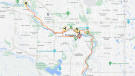
As of 7:40 a.m., Thursday 511 Alberta was showing impacts to highway conditions west and south of Calgary, with cameras also reflecting that.
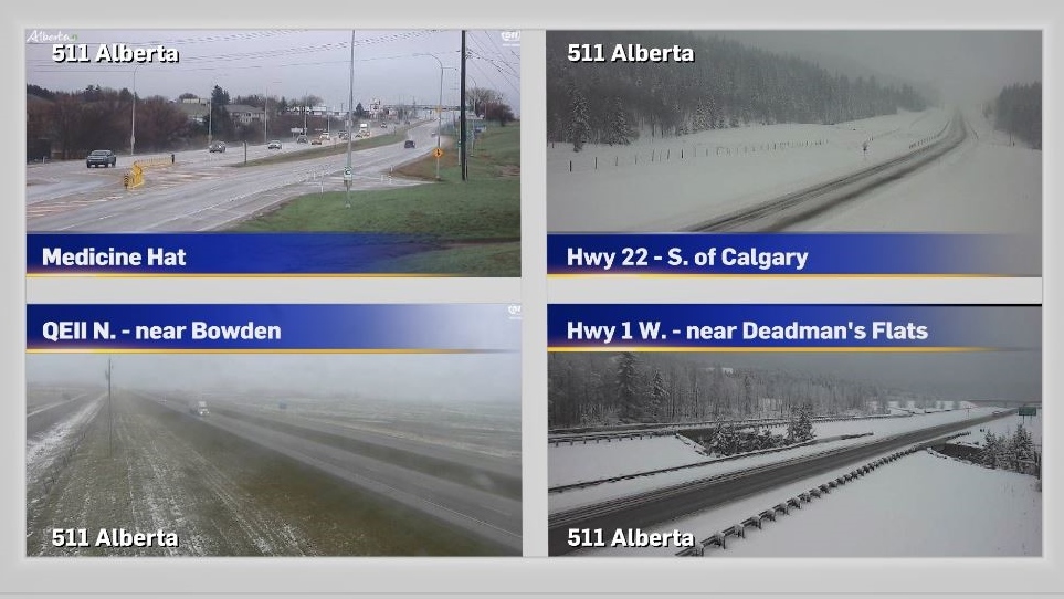
Layers will still be necessary on Thursday in Calgary. The forecast high of 7 C is still well below the seasonal average of 14 C, and north winds will remain strong throughout the day.
Friday will bring more sunshine with a high of 12 C, both of which will help melt accumulations at lower elevations.
Stability is still fragile however with rain likely to move in to southern Alberta on Sunday night and stick around under the middle of the week.


CTVNews.ca Top Stories

'Inspires a sense of adventure': Sask. man conquers Mount Everest
A Saskatchewan man made it to the summit of Mount Everest earlier this month.
Grayson Murray's parents say the two-time PGA Tour winner died of suicide
Grayson Murray's parents said Sunday their 30-year-old son took his own life, just one day after he withdrew from a PGA Tour event. The family asked for privacy and that people honor Murray by being kind to one another.
Some birds may use 'mental time travel,' study finds
Real quick — what did you have for lunch yesterday? Were you with anyone? Where were you? Can you picture the scene? The ability to remember things that happened to you in the past, especially to go back and recall little incidental details, is a hallmark of what psychologists call episodic memory — and new research indicates that it’s an ability humans may share with birds called Eurasian jays.
This type of screen time has the worst effect on kids: experts
According to some experts, there is one type of screen time that is continuously excessive, and it's having a severe effect on our children.
Hamas rocket attack from Gaza sets off air raid sirens in Tel Aviv for the first time in months
Hamas fired a barrage of rockets from Gaza that set off air raid sirens as far away as Tel Aviv for the first time in months on Sunday in a show of resilience more than seven months into Israel's massive air, sea and ground offensive.
Blaine Higgs 'furious' over sexual education presentation
New Brunswick Premier Blaine Higgs has shared his anger on social media over a presentation in at least four high schools.
Trump confronts repeated boos during raucous Libertarian convention speech
Donald Trump was booed repeatedly while addressing Saturday night’s Libertarian Party National Convention.
Indianapolis 500 delayed as strong storm forces fans to evacuate Indianapolis Motor Speedway
The start of the Indianapolis 500 was delayed as a strong storm pushed through the area Sunday, forcing Indianapolis Motor Speedway officials to evacuate about 125,000 fans who had already arrived for "The Greatest Spectacle in Racing."
Driver, 18, gets $3,000 ticket, 32 demerit points after speeding on Laval boulevard
A young driver received a hefty fine from Laval police after they say he was driving nearly 100 km/h over the posted speed limit.
Shopping Trends
The Shopping Trends team is independent of the journalists at CTV News. We may earn a commission when you use our links to shop. Read about us.


Edmonton
-

Protesters express anger at provincial government at 'Enough is Enough UCP' protest Saturday
Hundreds of protesters gathered at the Alberta legislature Saturday to express their discontent with Premier Danielle Smith and the UCP government.
-
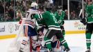
Stars beat Oilers 3-1 to even Western Conference final 1-1
Mason Marchment scored the winner early in the third period as the Dallas Stars beat the Edmonton Oilers 3-1 on Saturday to even the NHL's Western Conference final 1-1.
-
Appeal denied for Edmonton soldier accused of trying to kill her 3 children
An Edmonton woman found guilty of trying to kill her three children has been denied an appeal.
Lethbridge
-

Organizers have high hopes as Lethbridge launches collector and entertainment expo
The entertainment and collector expo in Lethbridge got underway Friday afternoon.
-
Lethbridge police, fire responders set to square off on the diamond in Battle of the Badges
A friendly competition between Lethbridge police officers and fire responders will take place Saturday, all for a good cause.
-
Maintenance work shuts down Lethbridge online services this weekend
People trying to access a variety of online services offered by The City of Lethbridge may run into a digital roadblock this weekend.
Vancouver
-

'Making his legacy come alive': Ball hockey tournament honours fallen B.C. RCMP Const. Rick O’Brien
Dozens gathered at a rink in Maple Ridge, B.C., on Saturday to play in a ball hockey tournament in honour of fallen B.C. RCMP Const. Rick O’Brien.
-
Whitecaps offering free tickets to fans attending Saturday's Messi-less match
In the wake of major disappointment among soccer fans who were hoping to see Lionel Messi play at BC Place on Saturday, the Vancouver Whitecaps are offering what seems to be a consolation prize.
-
Fatal plane crash reported near Squamish, B.C.
The Transportation Safety Board of Canada has confirmed it is working with local Mounties and the BC Coroners Service after a plane crash near Squamish, B.C. Friday night.
Vancouver Island
-

Whitecaps offering free tickets to fans attending Saturday's Messi-less match
In the wake of major disappointment among soccer fans who were hoping to see Lionel Messi play at BC Place on Saturday, the Vancouver Whitecaps are offering what seems to be a consolation prize.
-
Fatal plane crash reported near Squamish, B.C.
The Transportation Safety Board of Canada has confirmed it is working with local Mounties and the BC Coroners Service after a plane crash near Squamish, B.C. Friday night.
-
No merger: BC Conservatives rejected non-competition deal, BC United says
BC Conservatives have rejected a non-competition deal proposed by BC United, the party formerly known as the BC Liberals says, putting an end to talks about a possible merge between the two parties.
Saskatoon
-
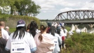
Hundreds walk in Saskatoon to raise awareness for Alzheimer's
A walking party of 200 people gathered at River Landing Amphitheatre on Saturday to prepare for either a one or four-kilometer walk to advocate awareness for Alzheimer's, dementia, and other neuro-degenerative diseases.
-
'Inspires a sense of adventure': Sask. man conquers Mount Everest
A Saskatchewan man made it to the summit of Mount Everest earlier this month.
-
Sask. swimmer qualifies for 2024 Olympic Games, sets Canadian record
A swimmer from Saskatoon has qualified for the 2024 Olympic Summer Games in Paris.
Regina
-
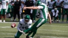
Lauther's late field goal lifts Roughriders over Elks 28-27 in pre-season action
Brett Lauther's 23-yard field goal with 23 seconds left lifted the Saskatchewan Roughriders to a 28-27 victory over the Edmonton Elks on Saturday in CFL pre-season action.
-
'Inspires a sense of adventure': Sask. man conquers Mount Everest
A Saskatchewan man made it to the summit of Mount Everest earlier this month.
-
Endangered little brown bats in prairies under study by university research teams
Research teams from the University of Regina and the University of Winnipeg are working to study migration patterns of the endangered little brown bat.
Toronto
-

'Bigger than just music:' Canadians remember Punjabi rapper two years after killing
Shub Karman was out for a recent walk in Calgary, when he passed a car full of kids singing along to the music of his favourite Punjabi rapper.
-
Female driver dead after collision in Oshawa
A female driver has died after a collision in Oshawa on Sunday morning, police say.
-
'Language is identity': Indigenous Ontario legislator to make history at Queen's Park
Decades after being punished in a residential school for speaking his own language, Sol Mamakwa will hold the powerful to account at Ontario's legislature in the very same language past governments tried to bury.
Montreal
-
About one Quebec child per day taken to ER for drowning, near-drowning: research
New research has found an average of one child a day goes to the emergency room for a drowning or near-drowning in Quebec during the summer months.
-
Quebec Liberals tout their credibility on managing public finances
The Liberals' credibility is 'through the roof' when it comes to managing public finances, said PLQ interim leader Marc Tanguay on Sunday at his party's general convention in a Bromont hotel.
-
Man, 27, dead after two-car collision in Plateau-Mont-Royal
A 27-year-old man died after a two-car collision in Montreal's Le Plateau-Mont-Royal borough overnight, police say.
Atlantic
-

Blaine Higgs 'furious' over sexual education presentation
New Brunswick Premier Blaine Higgs has shared his anger on social media over a presentation in at least four high schools.
-
57-year-old Carleton man dies following boating accident: P.E.I. RCMP
A 57-year-old man from Carleton, P.E.I., has died following a boating incident in the Summerside Harbour.
-
Man in custody after shots fired in Dartmouth: police
Halifax Regional Police say they were on scene of a weapons offense on Valkyrie Crescent in Dartmouth, N.S.
Winnipeg
-
Who is Buffalo Woman? Serial killer trial hears of police efforts to identify victim
In mid-March 2022, a young Indigenous woman stood outside Winnipeg's Salvation Army and spoke with a man who invited her back to his home.
-
Winnipeg firefighters tackle two fires overnight
Winnipeg firefighters battled two blazes Saturday night in Point Douglas and Daniel McIntyre.
-
‘It’s pretty alarming’: Urban wildlife encounters in Winnipeg this week
When you consider what kind of animals you might encounter in your Winnipeg neighborhood, a bear probably isn’t on your list.
Ottawa
-

Man seriously injured following an 'assault' on Downpatrick Road
The Ottawa Police Service says a 30-year-od man was seriously injured Sunday morning following what police call "an assault" on Downpatrick Road, in Ottawa's south-end.
-
Should you buy new or resale house? Here's what you need to know
There are many decisions to make before deciding to buy a house and one of those is whether to buy a new or a resale one.
-
Canadian 10K record broken at Ottawa Race Weekend
A new Canadian record in the 10 kilometre road race was set on Saturday during Ottawa Race Weekend.
Northern Ontario
-

No sign Canada has a plan to reach NATO defence spending target: U.S. NATO ambassador
The U.S. ambassador to NATO says she has seen no indication that Canada has a plan to reach the NATO spending target of two per cent of GDP on defence.
-
Suspect sought in suspicious death in northern Ont.
Ontario Provincial Police in Cochrane are asking for the public’s help in locating a man they want to speak with in connection with a suspicious death.
-
'Language is identity': Indigenous Ontario legislator to make history at Queen's Park
Decades after being punished in a residential school for speaking his own language, Sol Mamakwa will hold the powerful to account at Ontario's legislature in the very same language past governments tried to bury.
Barrie
-
Multi-vehicle crash causes road closures in Orangeville
A multi-vehicle collision has resulted in road closures in Orangeville.
-
Simcoe County residents unite to support those with multiple sclerosis
On Sunday, residents from Simcoe County gathered in Barrie to show their support for those with multiple sclerosis.
-
Coldwater Lions Club annual duck race returns
The annual Coldwater Duck Race, hosted by the Coldwater Lions Club, took place on Saturday.
Kitchener
-

Most-read stories of the week: Truck driver heroes, Kitchener strip club misconduct, population growth
Two Purolator truck drivers being hailed as heroes, misconduct in a Kitchener strip club, and population growth for the Region of Waterloo round out the most-read stories of the week.
-
KW Titans lose to London in Basketball Super League finals
Much like the Kitchener Rangers, the KW Titans season has ended at the hands of a team from London.
-
Disturbance in Waterloo involving racial slurs under investigation
Regional police are investigating a disturbance in Waterloo that involved racial slurs.
London
-

Huron County fire crews tackle blaze at Goderich, Ont. Home Hardware
Huron County fire crews spent Saturday evening extinguishing a fire at hardware store in Goderich.
-
'Wouldn’t miss this': Fans from all over North America attend Memorial Cup
Fans from across North America have come to Saginaw, Mich. to see the quest for junior hockey supremacy. During the fan fest event, CTV News London spoke with those from northern Quebec, Saskatchewan, Michigan, Ohio, British Columbia and Manitoba.
-
On the bright side with Julie Atchison
To brighten your week with good news, CTV London Meteorologist Julie Atchison is showing us the sunny side of things. Here's a look at the good news stories from the past week.
Windsor
-

Search underway for missing swimmer on Lake St. Clair
A search is currently underway for a Michigan man who police said jumped into the waters of Lake St. Clair on Saturday afternoon and did not resurface.
-
Suspect sought after teen boy repeatedly stabbed
Windsor police are searching for a suspect after a 16-year-old boy was stabbed multiple times following a verbal dispute on Saturday night.
-
50 people involved in 'physical altercation,' multiple youths arrested
Multiple youths have been arrested and charged after police responded to a 'physical altercation' involving approximately 50 people in Chatham Saturday night.


