Snowy start to the Easter weekend, double-digit highs to finish it off
As expected, Thursday began with a brief weather setback when a low-pressure system in central Alberta brought snow and mixed precipitation to the region.
Daytime highs (0 C in Calgary) happened early in the morning Thursday and north winds created a gap between the air temperature and the “feels like” temperature, with wind chill values around -8 to -10 for areas like Calgary, Drumheller and Brooks.
Impacts on travel were measurable throughout the morning on Thursday and likely to get worse.
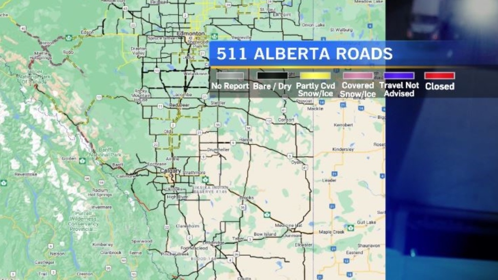 Driving conditions continued to deteriorate Thursday, per 511 Alberta. Snow-covered and icy routes were reported in central and northern Alberta as of 10 a.m. March 28, 2024. (CTV News)
The 511 Alberta map showed road conditions in portions of the province as bare and dry at 7 a.m. and snow-covered and icy by 10 a.m., with corresponding 511 Alberta highway cameras reflecting winter-driving conditions.
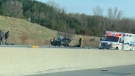
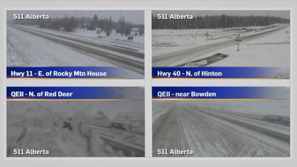 Central Alberta highway cameras from 511 Alberta at 10 a.m., March 28, 2024. (CTV News)
As that low tracks south Thursday and amplifies the upsloping component, heavier snowfall accumulations are expected in some areas, including along major commuter corridors like the QEII and Yellowhead (Highway 16) highways.
Calgary is forecast to receive a total of two to four centimetres of snow on Thursday and Friday, compared to regions in central Alberta which are along the cold front.
A snowfall warning issued Friday for Hinton, Jasper and Nordegg had been dropped by 10 a.m., and no other weather advisories were in place in Alberta.
With the progression of this system, areas in southwestern Alberta – including the Highway 22 corridor – could also see higher snowfall rates late Thursday. That low is expected to remain problematic east of the province developing into an Alberta Clipper by the weekend.
Despite the widespread instability Thursday, Friday is forecast to be Calgary’s coldest day of the Easter weekend with a daytime high 11 C below average.
Sunshine will return on Saturday, as a strong ridge of high pressure enters B.C. and Alberta.
On Monday, Calgary’s daytime high will hit 10 C – the warmest temperature since mid-March – and Tuesday could easily hit 17 C.
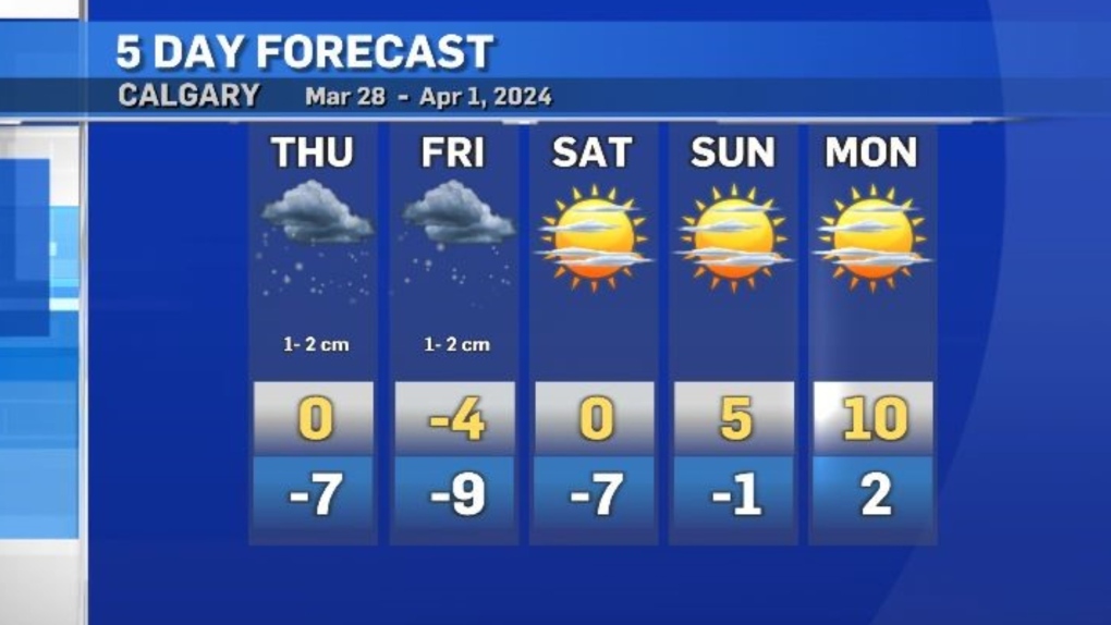 Calgary's five-day forecast for March 28-April 1, 2024. (CTV News)


CTVNews.ca Top Stories

'We are declaring our readiness': No decision made yet as Poland declares it's ready to host nuclear weapons
Polish President Andrzej Duda says while no decision has been made around whether Poland will host nuclear weapons as part of an expansion of the NATO alliance’s nuclear sharing program, his country is willing and prepared to do so.
Deadly six-vehicle crash on Highway 400 sparked by road rage incident
One person was killed in a six-vehicle crash on Highway 400 in Innisfil Friday evening.
Invasive and toxic hammerhead worms make themselves at home in Ontario
Ontario is now home to an invasive and toxic worm species that can grow up to three feet long and can be dangerous to small animals and pets.
First court appearance for boy and girl charged in death of Halifax 16-year-old
A girl and a boy, both 14 years old, made their first appearance today in a Halifax courtroom, where they each face a second-degree murder charge in the stabbing death of a 16-year-old high school student.
Central Alberta queer groups react to request from Red Deer-South to reinstate Jennifer Johnson to UCP caucus
A number of LGBQT+2s groups in Central Alberta are pushing back against a request from the Red Deer South UCP constituency to reinstate MLA Jennifer Johnson into the UCP caucus.
Opinion
Opinion I just don't get Taylor Swift
It's one thing to say you like Taylor Swift and her music, but don't blame CNN's AJ Willingham's when she says she just 'doesn't get' the global phenomenon.
Sophie Gregoire Trudeau on navigating post-political life, co-parenting and freedom
Sophie Gregoire Trudeau says there is 'still so much love' between her and Prime Minister Justin Trudeau, as they navigate their post-separation relationship co-parenting their three children.
It's 30 years since apartheid ended. South Africa's celebrations are set against growing discontent
South Africa marked 30 years since the end of apartheid and the birth of its democracy with a ceremony in the capital Saturday that included a 21-gun salute and the waving of the nation's multicolored flag.
Last letters of pioneering climber who died on Everest reveal dark side of mountaineering
George Mallory is renowned for being one of the first British mountaineers to attempt to scale the dizzying heights of Mount Everest during the 1920s. Nearly a century later, newly digitized letters shed light on Mallory’s hopes and fears about ascending Everest.
Shopping Trends
The Shopping Trends team is independent of the journalists at CTV News. We may earn a commission when you use our links to shop. Read about us.


Edmonton
-

Kane makes impact with Gordie Howe hat trick, Oilers rout Kings to take series lead
Evander Kane’s teammates believe he’s tailor-made for the playoffs, and so does the man himself.
-
Central Alberta queer groups react to request from Red Deer-South to reinstate Jennifer Johnson to UCP caucus
A number of LGBQT+2s groups in Central Alberta are pushing back against a request from the Red Deer South UCP constituency to reinstate MLA Jennifer Johnson into the UCP caucus.
-
Haida elder suing Catholic Church and priest, hopes for 'healing and reconciliation'
The lawyer for a residential school survivor leading a proposed class-action defamation lawsuit against the Catholic Church over residential schools says the court action is a last resort.
Lethbridge
-

Bandits get hat trick from Logan Sawyer en route to 8-2 win over Okotoks
The Brooks Bandits got down to business Friday, defeating the Okotoks Oilers 8-2.
-
'No real winner' following first Alberta NDP leadership debate: political scientist
An Alberta political scientist said the NDP leadership hopefuls remained fairly even following the first of the party’s debates.
-
Multiple grass fires sparked near Kipp rail yard
It was a busy Wednesday evening for fire crews in Lethbridge County after multiple grass fires were sparked near the Kipp rail yard.
Vancouver
-

Woman found dead inside Surrey home, homicide investigators called in
A large police presence in Surrey's East Newton neighbourhood Friday night is now a homicide investigation, local Mounties said Saturday.
-
King George SkyTrain station closed for 6 weeks
King George SkyTrain Station closed Saturday morning and won't be open again for weeks.
-
Evacuation alert lifted as wildfire in northeastern B.C. now 'held'
An evacuation alert for residents in areas around Chetwynd, B.C., has been lifted just days after a wildfire forced some residents from their homes.
Vancouver Island
-

Canucks defeat Predators in Game 3, take 2-1 series lead
J.T. Miller had a goal and assist and the Vancouver Canucks edged the Nashville Predators 2-1 to re-take the lead in their first-round playoff series.
-
Haida elder suing Catholic Church and priest, hopes for 'healing and reconciliation'
The lawyer for a residential school survivor leading a proposed class-action defamation lawsuit against the Catholic Church over residential schools says the court action is a last resort.
-
Cisco reveals security breach, warns of state-sponsored spy campaign
State-sponsored actors targeted security devices used by governments around the world, according to technology firm Cisco Systems, which said the network devices are coveted intrusion points by spies.
Saskatoon
-

Saskatoon care home workers escalating strike action
Workers at group homes run by LutherCare Communities in Saskatoon are escalating their strike action.
-
Saskatoon police investigating after body found at recycling facility
The Saskatoon Police Service (SPS) and Saskatchewan Coroners Service are investigating after a woman’s body was found at a recycling facility Friday morning.
-
Saskatchewan's $90M social services initiative underway
Over six months after Saskatchewan's government announced a significant $90 million investment in social services, the initiative is reportedly making progress.
Regina
-

Teen boy charged after stealing from Regina business
A teen boy is facing several charges after he stole items from a business on Friday in Regina.
-
Regina fire crews respond to late night blaze
Regina fire crews responded to a late night blaze on Friday night at a house on the 1900 block of St. John Street.
-
Man charged with murder, victim identified in southeast Sask. homicide case
RCMP have identified 28-year-old Brianna Hayes from Oxbow, Sask. as the victim in an ongoing homicide investigation in the province’s southeast. As a result, police have charged 24-year-old Taylor Japp, also from Oxbow with second degree murder, an RCMP news release said.
Toronto
-

Toronto Maple Leafs winger William Nylander on course to suit up in Game 4 against Bruins
William Nylander is poised to join the Stanley Cup chase.
-
Invasive and toxic hammerhead worms make themselves at home in Ontario
Ontario is now home to an invasive and toxic worm species that can grow up to three feet long and can be dangerous to small animals and pets.
-
Murder charge laid after man falls to death from Toronto apartment balcony
One person has been charged with second-degree murder in connection with the death of a man who fell from a balcony following an altercation inside a Toronto apartment building.
Montreal
-

Canada's Leylah Fernandez out of Madrid Open in third-round loss to Jabeur
Canadian tennis player Leylah Fernandez was ousted Saturday in the third round of the Madrid Open in a three-set loss to Tunisia's Ons Jabeur.
-
Montreal comic book artists claim Marvel abusing legal system in copyright battle
Montreal comic book artists Ben and Ray Lai claim Marvel and Disney are abusing the legal process in the Lai brothers' copyright infringement suit against the industry giants.
-
Driver arrested after woman, 51, dies in head-on collision in Lachute
Quebec provincial police say a 51-year-old woman has died after a head-on collision in the town of Lachute, roughly 50 kilometres west of Montreal, early this morning.
Atlantic
-

Bidders express interest in buying all or part of SaltWire newspaper business
A Toronto-based restructuring firm says several bidders have offered to buy all or part of SaltWire Network and The Halifax Herald, the two insolvent companies that operate Atlantic Canada's largest newspaper enterprise.
-
Halifax Wanderers kick off season with home opener against Ottawa
Halifax’s professional soccer team kicks off its sixth season against Ottawa on Saturday with a sold-out crowd of 6,500 fans on the Wanderers Grounds.
-
Man wanted on Canada-wide warrant arrested in Saint John
Police say a man wanted on a Canada-wide warrant has been arrested in Saint John, N.B.
Winnipeg
-

A timeline of the Jeremy Skibicki case
The trial for the man accused of killing four Indigenous women in Winnipeg is set to get underway on April 29.
-
Winnipeg emergency crews battle 5 fires in 6 hours Saturday morning
Winnipeg Fire Paramedic Service crews were busy Saturday morning, responding to five different structure fires within several hours.
-
Impaired driver collides with police car in Brandon
A 29-year-old man is facing charges after police said he hit an officer’s vehicle at the Richmond Avenue Co-op in Brandon.
Ottawa
-

Trucker from Newfoundland missing in eastern Ontario
Ontario Provincial Police are asking for the public's help in locating a missing man from Newfoundland who disappeared in eastern Ontario.
-
No injuries reported following single-vehicle collision on Highway 15 in eastern Ontario
The Ontario Provincial Police (OPP) asked drivers to expect delays after a single-vehicle collision on Highway 15 near Brewers Mills Road Saturday morning.
-
City of Ottawa releases draft 1 of new zoning bylaw
The City of Ottawa says the release of the first draft provisions for Ottawa’s new zoning bylaw marks the start of the next step of the city’s growth and development.
Northern Ontario
-

Northern Ont. hunters fined $8,500 for illegal moose hunt
Two hunters from North Bay, Ont., and a third from Temagami pled guilty recently to offences they committed during a 2022 moose hunt.
-
Invasive and toxic hammerhead worms make themselves at home in Ontario
Ontario is now home to an invasive and toxic worm species that can grow up to three feet long and can be dangerous to small animals and pets.
-
Police in northern Ont. attacked by person they found lying in the street
Ontario Provincial Police responding to a disturbance in West Nipissing this week discovered a conscious person lying in the street.
Barrie
-
Deadly six-vehicle crash on Highway 400 sparked by road rage incident
One person was killed in a six-vehicle crash on Highway 400 in Innisfil Friday evening.
-
Annual Tender Hearts gala helps to support grieving children
A gala helping to support children through their darkest days saw dozens of people come together Friday night in Barrie.
-
Caledon OPP investigating serious two-vehicle crash
Police in Caledon are investigating a crash that left one person with life-altering injuries.
Kitchener
-

Kitchener family says their 10-year-old needs life-saving drug that cost $600,000
Raneem, 10, lives with a neurological condition and liver disease and needs Cholbam, a medication, for a longer and healthier life.
-
Pedestrian seriously hurt following hit-and-run crash in Cambridge, driver arrested
A driver has been arrested and a pedestrian has been seriously injured following a hit-and-run crash in Cambridge.
-
Long faces around horse riding school as it prepares to close after 50 years
An established horse riding school in Centre Wellington is hanging up the saddle after five decades in business.
London
-

Fatal crash victim identified as 24-year-old Western University graduate
A 24-year-old man who died Friday in a car crash on Highway 401 has been identified as Omar Barzak from London, Ont.
-
'I felt disappointed': Local women’s advocates lament MP Karen Vecchio’s ouster as Status of Women Committee chair
At an event in which she was celebrated for her advocacy of women’s issues, Karen Vecchio was in no mood to speak about her removal from her role of chair of Federal Parliament’s Status of Women Committee.
-
PLAYOFF TRACKER
PLAYOFF TRACKER London Knights defeat Saginaw in game 1 of Western Conference Finals
The London Knights resumed their playoff push on Friday night against the Saginaw Spirit at Budweiser Gardens.
Windsor
-

Windsorite Theo Johnson selected by New York Giants in NFL Draft
A former graduate of Holy Names High School will soon be moving to New York after being selected during the NFL Draft in Detroit on Saturday.
-
'It’s just life changing': No need to sell home after Windsorite wins 100K
Playing bingo in April made a local resident $100,000 richer -- and will keep him in his home.
-
From backyard to professional pitch: Workshop gives opportunity to young aspiring players
Kids who have never played league soccer but have been eager to step on a professional turf are getting their first opportunity to shine. Thanks to a microgrant from Soccer Canada, the Windsor Soccer Club hosted a Free Kicks Day at the Novelletto Rosati Complex on Saturday.


