Warm weather comes to an abrupt end Monday night
A mild Sunday night leads into a warm start to the work week, but don’t let that deceive you. Winter storm conditions expected for much of the province, starting in northern regions Monday morning.
That snow moves into central Alberta by the afternoon, coupled with a cold front swinging through the province, bringing gusty winds and plummeting temperatures.
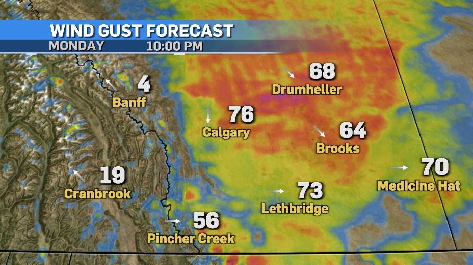
Wind gusts across central and southern regions could reach 70-90 km/h by Monday evening, causing blowing snow, poor visibility, and road conditions.
Snow tapers off through Tuesday morning as wind speeds diminish. Generally, 5-10 cm is expected across central and southern Alberta, but the foothills may see greater totals.
The cold settles in Tuesday, with temperatures slightly moderating mid-week before warm weather returns in the second half of the week.
Here’s the five day:
Monday:
- Sunny in the morning, increasing cloudiness late afternoon
- Daytime high: 9 C
- Overnight: Temperatures plummet, winds gust to 70 km/h, blowing snow, low -16 C, wind chill -25
Tuesday:
- Chance of early morning flurries, partly cloudy after that
- Daytime high: -13 C
- Overnight: Clearing, -22 C
Wednesday:
- Mostly sunny
- Daytime high: -9 C
- Overnight: Becoming mostly cloudy, -12 C
Thursday:
- Becoming mostly cloudy
- Daytime high: 4 C
- Overnight: Partly cloudy, -2 C
Friday:
- Clearing
- Daytime high: 2 C
- Overnight: Clearing, -1 C
CTVNews.ca Top Stories

Trudeau appears unwilling to expand proposed rebate, despite pressure to include seniors
Prime Minister Justin Trudeau does not appear willing to budge on his plan to send a $250 rebate to 'hardworking Canadians,' despite pressure from the opposition to give the money to seniors and people who are not able to work.
'Mayday!': New details emerge after Boeing plane makes emergency landing at Mirabel airport
New details suggest that there were communication issues between the pilots of a charter flight and the control tower at Montreal's Mirabel airport when a Boeing 737 made an emergency landing on Wednesday.
Cucumbers sold in Ontario, other provinces recalled over possible salmonella contamination
A U.S. company is recalling cucumbers sold in Ontario and other Canadian provinces due to possible salmonella contamination.
Latest updates: Tracking RSV, influenza, COVID-19 in Canada
As the country heads into the worst time of year for respiratory infections, the Canadian respiratory virus surveillance report tracks how prevalent certain viruses are each week and how the trends are changing week to week.
Weekend weather: Parts of Canada could see up to 50 centimetres of snow, wind chills of -40
Winter is less than a month away, but parts of Canada are already projected to see winter-like weather.
Atlantic hurricane season comes to an end, leaving widespread damage in its wake in U.S.
The 2024 Atlantic hurricane season comes to a close Saturday, bringing to an end a season that saw 11 hurricanes compared to the average seven.
Armed men in speedboats make off with women and children when a migrants' dinghy deflates off Libya
Armed men in two speedboats took off with women and children after a rubber dinghy carrying some 112 migrants seeking to cross the Mediterranean Sea started deflating off Libya's coast, a humanitarian aid group said Friday.
Federal government posts $13B deficit in first half of the fiscal year
The Finance Department says the federal deficit was $13 billion between April and September.
W5 Investigates A 'ticking time bomb': Inside Syria's toughest prison holding accused high-ranking ISIS members
In the last of a three-part investigation, W5's Avery Haines was given rare access to a Syrian prison, where thousands of accused high-ranking ISIS members are being held.


