Strong storm potential for parts of Alberta Tuesday afternoon
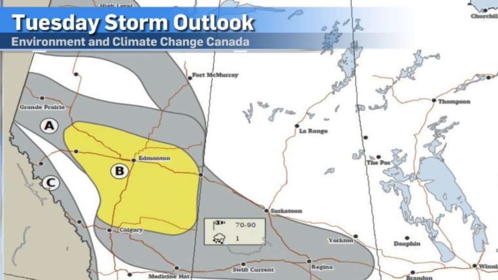
Parts of southern and central Alberta are poised to be in the path of some potentially severe storm weather this afternoon.
At this point, It's tricky to determine whether Calgary will be caught up in the activity or just missing it.
According to Environment and Climate Change Canada’s (ECCC) storm outlook for Tuesday, Calgary is situated just outside the moderate storm risk zone, but a slight change in storm trajectory could see the city dealing with storm cells that could produce lightning, hail and strong winds.
Thunderstorm watches and warnings are likely to pop up later Tuesday in the areas on the ECCC storm outlook.
In areas to the north of Calgary along the QEII and eastwards, instability is strong enough to set the stage for supercell development, most notably in Edmonton, Lloydminster and Coronation.
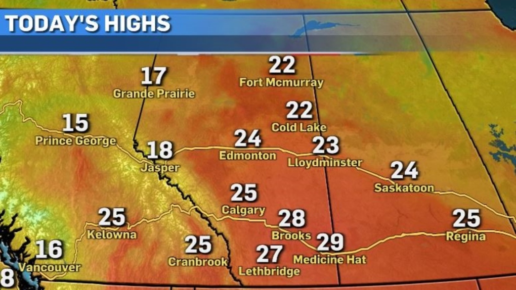
 From a temperature standpoint, Tuesday is looking to be the hottest day of the week in Calgary with a high of 25 C.
This forecast high would also be the second-warmest temperature for Calgary so far this year, with the warmest day of 2024 so far being May 10 with a high of 26.2 C.
Areas in the southeast like Medicine Hat will get close to the 30 C mark later Tuesday.
 The upper low pressure system influencing storm activity will hover around the Alberta/Saskatchewan border overnight and into Wednesday afternoon, producing steady rain showers.
It will also bring some slightly cooler air to the south, which will somewhat disrupt the warming trend resulting in a seasonal high of 20 C.
High pressure winds out later tomorrow and will keep temperatures and conditions pleasant for the remainder of the work week, then back to cool and unsettled conditions for the weekend.


CTVNews.ca Top Stories

Stellantis recalling nearly 1.2 million vehicles to fix software glitch that disables rear camera
Stellantis is recalling nearly 1.2 million vehicles in the U.S. and Canada to fix a software glitch that can disable the rearview cameras.
Canada sanctions 13 more Russians for role in Navalny's imprisonment and death
Canada is sanctioning 13 more Russians from the intelligence service, police force and corrections system for their role in the poisoning, imprisonment and death of opposition leader Alexei Navalny.
South Korean soldiers fire warning shots after North Korean troops cross border, apparently in error
South Korean troops fired warning shots to repel North Korean soldiers who briefly crossed the rivals' heavily fortified land border Tuesday for the second time this month, the South's military said. Both incursions were believed to be unintentional.
Obituary
Obituary French actress Anouk Aimee, a Golden Globe-winner for her role in 'A Man and a Woman,' dies at 92
French actress Anouk Aimee, winner of a Golden Globe for her starring role in 'A Man and a Woman' by legendary French director Claude Lelouch, has died. She was 92.
Staples stores begin accepting Amazon returns under new partnership
Canadians can now return their Amazon orders through Staples. The e-commerce giant says the office supply retailer's 298 stores are now equipped to handle Amazon returns.
3 people dead, including gunman, after shooting in Toronto office space: police
The gunman who killed a man and a woman is among the deceased after a triple shooting inside an office space near a daycare and a school in North York on Monday afternoon, according to police.
EXCLUSIVE
EXCLUSIVE 'They were literally feral': Demands for answers in horrific B.C. case of child neglect
A horrific case of child neglect involving three young children has their extended family in northern B.C. demanding answers.
Ottawa couple's loan payments more than double after new company takes over financing
An Ottawa couple is sharing their buyer beware story and the importance of reading the fine print in contracts, following a shocking price hike and interest rate adjustment for their home furnace financing.
Secret Service agent robbed at gunpoint during Biden's Los Angeles trip, police say
A U.S. Secret Service agent was robbed at gunpoint as President Joe Biden was visiting Los Angeles for a fundraising event over the weekend, officials said.
Shopping Trends
The Shopping Trends team is independent of the journalists at CTV News. We may earn a commission when you use our links to shop. Read about us.


Edmonton
-

Connor McDavid led the Oilers to the Stanley Cup Final. They need even more from him to stay alive
Connor McDavid led the Edmonton Oilers out of a horrendous start, all the way to the playoffs and into the Stanley Cup Final.
-
'Do you guys have tickets?': How a nightmare of a road trip turned into Stanley Cup Final front-row seats for father and daughter
A road trip for a father and daughter that began as a nightmare quickly turned into a dream come true for the pair thanks to a couple of generous Oilers fans.
-
Frost Advisory for central and north-central Alberta
A chilly morning is on tap for most of central and north-central Alberta Tuesday.
Lethbridge
-

More pollen on the way for southern Alberta this summer
Pharmacies in southern Alberta were as busy as ever this spring, with many people seeking allergy relief in April and May.
-
City providing free daisies for Lethbridge to celebrate loved ones on Father’s Day
This Sunday is Father’s Day and the City of Lethbridge is helping those honour the memory of loved ones.
-
Jack Ady Cancer Centre unveils Amir and Saker Manji Healing Garden
The Amir and Saker Manji Healing Garden was named after Amir Manji, who went through his own cancer journey, and comes following a $500,000 donation toward the centre from his family.
Vancouver
-

Family and friends of Naomi Onotera face man who killed her at sentencing hearing
People in the gallery openly wept Monday as friends and family of Naomi Onotera took the stand at a sentencing hearing to share stories about positive ways she touched their lives — and the devastating impact her death at the hands of her husband has had on them.
-
Property owners take NDP government to court over new short-term rental rules
A handful of members of a group of property owners from across B.C., known as the West Coast Association of Property Owners, assembled outside the B.C. Supreme Court in Victoria on Monday during a break in their court case.
-
B.C. more than doubles fines for illegal hunting, other wildlife offences
Starting this week, people caught illegally hunting or fishing will face much stiffer penalties under B.C.'s Wildlife Act.
Vancouver Island
-

Property owners take NDP government to court over new short-term rental rules
A handful of members of a group of property owners from across B.C., known as the West Coast Association of Property Owners, assembled outside the B.C. Supreme Court in Victoria on Monday during a break in their court case.
-
B.C. more than doubles fines for illegal hunting, other wildlife offences
Starting this week, people caught illegally hunting or fishing will face much stiffer penalties under B.C.'s Wildlife Act.
-
Inmate serving life sentence for B.C. sledgehammer murder dies in prison
A convicted killer who was serving a life sentence for the first-degree murder of his business partner has died in a British Columbia prison.
Saskatoon
-

Saskatoon transit users, organizers split on how to deal with free riders
As the city looks at ways to improve transit safety for drivers and users, it also finds itself struggling to deal with another growing concern on city buses: fare evasion.
-
Sask. home destroyed by fire was a pivotal location in a high-profile murder trial
The following story contains details some readers may find disturbing.
-
Saskatchewan researchers lead NASA project to measure aerosols in the upper atmosphere
Researchers at the University of Saskatchewan (U of S) are hard at work on a project that will help measure aerosols and clouds from space.
Regina
-

Sask. Party blocks full investigation into speaker allegations, opposition criticizes move
A full investigation into allegations made by legislative Speaker Randy Weekes against Sask. Party MLAs, including former Government House Leader Jeremy Harrison, has been blocked – much to the opposition's disappointment.
-
'Would be a very big loss': Regina residents opposed to allowing vehicles on Scarth Street Mall
For nearly 50 years, Scarth Street Mall has been for pedestrians only. It was deemed a walk-in corridor after a bylaw was passed all the way back in 1975.
-
Highway 1 crash causes significant traffic hang-up east of Regina
A crash on Highway 1 just east of Regina was the cause of significant traffic delays on Monday.
Toronto
-

'Cluster' of thunderstorms roll into Toronto amid prolonged heat wave in the city
A special weather statement has been issued for Toronto this morning as a 'cluster' of thunderstorms roll into the GTA.
-
Will Toronto legislate a maximum temperature in apartments?
Anushen Selvasegar can barely fit his hand through the narrow opening in his bedroom window to feel the breeze outside of his 14th-floor apartment in St. James Town, one of Toronto's most densely populated neighbourhoods.
-
Opioid deaths in Ontario shelters more than tripled during pandemic, study finds
A new study examining data from the Ontario coroner's office and other sources indicates opioid-related deaths in the province's shelters more than tripled during the COVID-19 pandemic, when compared with a few years prior.
Montreal
-

Her 83-year-old mother was defrauded of thousands of dollars. Now she wants to warn others
A Montreal woman is warning others after she says her 83-year-old mother was defrauded out of thousands of dollars -- and it all started with a simple phone call.
-
Teen stabbed on grounds of Montreal North high school, suspect is likely a minor
A teenager has been stabbed on the grounds of a school in Montreal North, according to Montreal police.
-
HEAT WARNING
HEAT WARNING Montreal under heat warning as humidex expected to exceed 40
The Greater Montreal area is under a heat warning as humidex values are expected to exceed 40 on numerous days this week.
Atlantic
-

Halifax redevelopment project hits milestone as motorists deal with traffic congestion
The closing of a section of Barrington Street means the Cogswell Street redevelopment project in Halifax has reached an important stage.
-
Hottest weather of the year so far coming to the Maritimes
A heat dome developing in the eastern United States will bring the hottest temperatures and highest humidex values of the year so far to the Maritimes this week.
-
Trial date set for one of the accused in connection with murder of Cape Breton woman
A trial date has been set for one of the accused in connection with a murder of a Cape Breton woman last year.
Winnipeg
-

Voters head to the polls Tuesday in Tuxedo byelection
Voters head to the polls Tuesday to elect a new MLA in the constituency of Tuxedo.
-
'A very heinous event': Teenage girls sexually assaulted during break-in
A Winnipeg man faces a slew of charges after police say he broke into an apartment building and sexually assaulted two teenage girls minutes after trying to break into another home nearby.
-
RCMP searching for three missing children, mother reported missing in Ontario last year
Manitoba RCMP are asking for help from the public to find an Ontario mother who is wanted for allegedly abducting her three children in December 2023.
Ottawa
-
 HEAT WARNING
HEAT WARNING Hot and humid weather continues in Ottawa, with the humidex to make it feel like 42
It's day two of the hot and humid weather in Ottawa, with the humidex expected to make it feel like 42 this afternoon.
-
Ottawa couple's loan payments more than double after new company takes over financing
An Ottawa couple is sharing their buyer beware story and the importance of reading the fine print in contracts, following a shocking price hike and interest rate adjustment for their home furnace financing.
-
Two Ottawa residents compete on 'Jeopardy!' this week
Getting on the gameshow Jeopardy is said to be statistically harder than getting in to Harvard, but this week, two of the contestants competing on the show just happen to be from Ottawa.
Northern Ontario
-

Witnesses say suspects pointed handgun at them near northern Ont. gas station
Ontario Provincial Police have released security camera photos of three of four suspects wanted in for questioning in a handgun-related incident.
-
3 people dead, including gunman, after shooting in Toronto office space: police
The gunman who killed a man and a woman is among the deceased after a triple shooting inside an office space near a daycare and a school in North York on Monday afternoon, according to police.
-
EXCLUSIVE
EXCLUSIVE 'They were literally feral': Demands for answers in horrific B.C. case of child neglect
A horrific case of child neglect involving three young children has their extended family in northern B.C. demanding answers.
Barrie
-
Environment Canada releases special weather statement for Owen Sound area
Thunderstorms with heavy winds could also strike the Blue Mountains and Grey County.
-
Fatal rollover in East Gwillimbury
A young man lost his life in a tragic crash in East Gwillimbury.
-
Barrie opens cooling centres due to heat warning
Barrie has opened cooling centres for residents to enjoy cooling off during the current heatwave.
Kitchener
-

Extreme heat and humidity in southern Ontario all week
Sweltering temperatures have settled across southern Ontario and Environment Canada says the dangerously hot and humid weather will be sticking around for the rest of the week.
-
How to navigate the long childcare waitlist in Waterloo Region
The promise of cheaper childcare means waitlists have grown longer. Wondering what to do until a spot opens up? We get advice for parents and caregivers.
-
City of Kitchener proposes bylaw to protect renters
A rental replacement bylaw is up for discussion in Kitchener. But, the city warns, it would only apply to some tenant evictions.
London
-

New city hall on Richmond Street? Farhi Holdings pitches land deal
As council considers a renovation and expansion to London’s existing city hall campus, the downtown’s largest property owner is offering to sell three of his buildings to create a brand new city hall.
-
Heat event continues with chance of showers and thunderstorms
A heat warning remains in effect from Environment Canada with the reminder that hot and humid air can also bring deteriorating air quality and can result in the Air Quality Health Index approaching the high risk category.
-
Guilty plea and life sentence in Meaford murder case
Matthew McQuarrie will spend at least the next 15 years behind bars after pleading guilty to second degree murder in the fatal stabbing of Emerson Sprung.
Windsor
-

Stellantis recalling nearly 1.2 million vehicles to fix software glitch that disables rear camera
Stellantis is recalling nearly 1.2 million vehicles in the U.S. and Canada to fix a software glitch that can disable the rearview cameras.
-
Jury quickly returns verdict in Windsor, Ont. murder trial
A jury only needed four hours to decide a verdict in a Windsor murder trial.
-
Heat event continues across Windsor-Essex, southern Ontario
A prolonged heat event continues Tuesday across southern Ontario. Dangerously hot and humid conditions are expected through the week and perhaps into the weekend.


