Above-normal highs continuing through the weekend
If Calgary's five-day forecast was a rollercoaster, we would be at the part of the ride where you’re climbing up the tall ramp before the big drop.
A ridge of high pressure in the upper atmosphere has started to settle over Alberta and will remain in place for the rest of the week.
On Thursday, we will warm up to a high of 12 C in the afternoon – a degree above normal for this time of year – but clouds will start to thicken up around 4 p.m. Winds will also be fairly breezy today out of the south at 20 to 40 km/h.
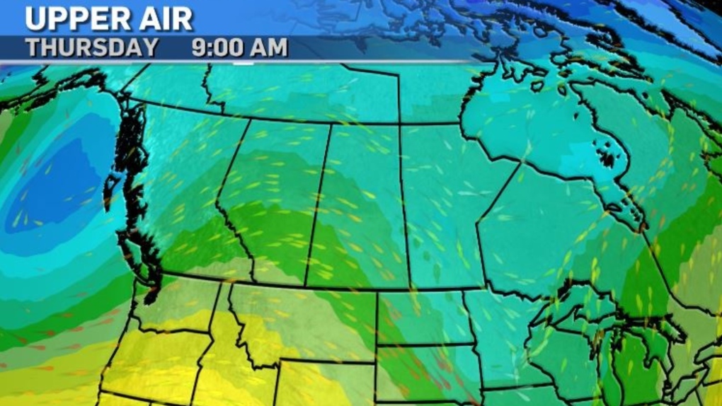 An upper air map showing conditions as of 8 a.m. on April 11, 2024. (CTV News)
Our temperatures will continue to climb and hit the mid-teens by Saturday and Sunday with mainly sunny conditions throughout the weekend.
It’s Monday when our rollercoaster ride rapidly heads downhill.
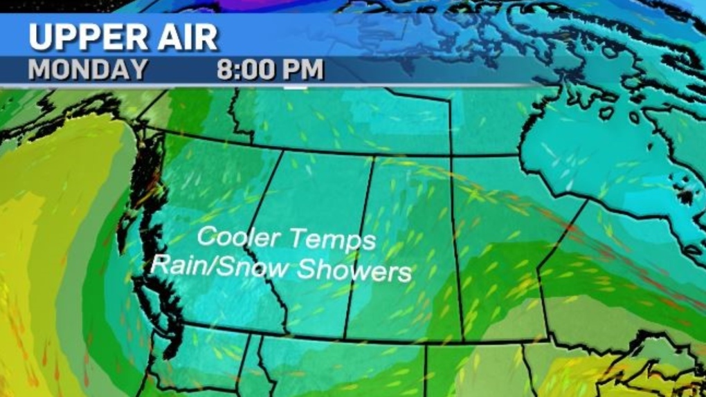 Conditions will change on Monday, as cooler temperatures move in bringing rain and snow on Monday, April 15, 2024. (CTV News)
A trough of low pressure residing over the North Pacific will force its way into western Canada by mid-April, pushing our highs into the single digits and bringing rain, snow and wind in its wake.
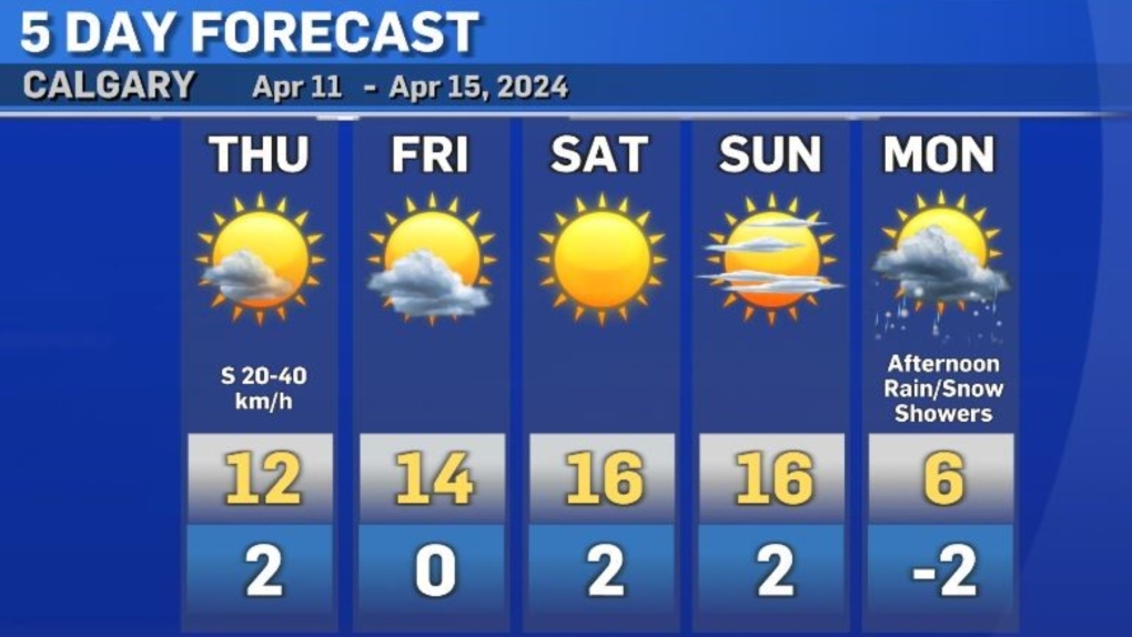 Calgary five-day forecast for April 11-15, 2024. (CTV News)
Long-range models are conflicted on how this low-pressure system will move around after Monday, but there is agreement that cooler temperatures fueled by this low will likely continue through much of next week.


CTVNews.ca Top Stories

'No one has $70,000 dollars lying around': Toronto condo owners facing massive special assessment
The owners of a North York condominium say they are facing a $70,000 special assessment to fix their building's parking garage. '$70,000 is a lot of money. It makes me very nervous and stressed out of nowhere for this huge debt to come in,' said Ligeng Guo.
Police ID mom, daughter killed in Old Montreal; video shows person break into building before fatal fire
Police released the identities of the mother and daughter who were killed after a fire tore through a 160-year-old building in Old Montreal on Friday.
Tropical Storm Milton forms in Gulf of Mexico, could intensify as a hurricane threatening Florida
Tropical Storm Milton has formed in the Gulf of Mexico. It is located 220 miles (355 kilometres) north-northeast of Veracruz, Mexico.
Trump rallies at same Pennsylvania grounds where gunman tried to assassinate him
Donald Trump picked up where he left off back in July when a gunman tried to assassinate him but only struck his ear before he raised his fist and shouted “Fight!” and was whisked away with blood across his face.
'I screamed in shock and horror': Family faces deadly Vancouver hit-and-run driver during sentencing
The sentencing of the man who pleaded guilty in the deadly hit-and-run in Kitsilano two years ago began on Friday.
Frequent drinking of fizzy beverages and fruit juice are linked to an increased risk of stroke: research
New data raises questions about the drinks people consume and the potential risks associated with them, according to researchers at Galway University in Ireland, in partnership with Hamilton’s McMaster University.
Northwestern Ont. woman charged with arson with disregard for human life
A 30-year-old northwestern Ontario woman has been charged with arson following a structure fire Thursday night, police say.
Inter Miami star Lionel Messi draws a crowd for arrival at Toronto's BMO Field
Argentine star Lionel Messi was on the bench to start Inter Miami CF's game in Toronto on Saturday.
Looking for cheap flights for the holidays? Here are some tips to remember
Travelling on a budget can be stressful, but there are ways you can ensure you're getting the best deal on flights as the holiday season approaches.
Shopping Trends
The Shopping Trends team is independent of the journalists at CTV News. We may earn a commission when you use our links to shop. Read about us.


Edmonton
-

'We're losing billions of birds': Backyard risks to Alberta's birds and how you can help make fall migration a successful one
An estimated four billion birds will navigate man-made environments as they travel south from North America during fall migration. Tens of million of them will die en route due to human-created hazards.
-
Crash between motorcycle and van closes Highway 39 near Warburg
Highway 39 near Warburg was closed Saturday after a serious crash involving a motorcycle and a van.
-
'They make me dig deep': 63-year-old CFR champion looks for 2nd win in Saturday finals
Barrel racer pro Lynette Brodoway has been riding in rodeos since before some of her competitors were born.
Lethbridge
-

Slow down! Lethbridge County pleads with motorists in construction zones
While the summer may be over, construction season in Lethbridge is not.
-
Lethbridge police seize fentanyl, weapons, stolen vehicle in downtown enforcement project
Lethbridge police executed dozens of warrants and laid numerous charges in another targeted enforcement project in the downtown area.
-
Driver airlifted following serious crash in Taber, Alta.
A person was airlifted to hospital following a serious crash in Taber, Alta., on Friday morning. Taber RCMP responded to the scene on Highway 864 around 10:30 a.m., for a crash involving an SUV and a semi-truck.
Vancouver
-

Crews battle massive fire in Langley city Saturday
Fire crews battled a massive blaze in downtown Langley Saturday morning.
-
Car flies into B.C. backyard, lands upside down
A driver suffered only minor injuries after going airborne in a residential neighbourhood in Maple Ridge, B.C., on Friday, the car eventually landing on its roof in someone’s backyard.
-
2nd-degree murder charge laid nearly 2 years after Kelowna stabbing
Nearly two years after a man was stabbed to death in downtown Kelowna, RCMP have made an arrest in the case.
Vancouver Island
-

Eby promises $75 million rural health loan forgiveness plan at Okanagan campaign stop
NDP Leader David Eby is promising to offer a $75-million loan forgiveness program to entice doctors, nurses and heath professionals to expand health-care services in rural British Columbia.
-
Saanich police warn of another Taylor Swift ticket scam
Ever since Taylor Swift made thousands, if not millions, of loyal fans’ wildest dreams come true by announcing a three-show run in Vancouver this December, scammers have attempted, and sometimes succeeded, to take advantage of the scramble for tickets.
-
Teachers' union wants education focus in B.C.'s 2024 election
We haven't heard the candidates talk much about education during B.C.'s 2024 election campaign, but the teachers' union is trying to put the spotlight on that issue.
Saskatoon
-

Private school funding draws attention during STF education forum
The Saskatchewan Teachers' Federation hosted a virtual election forum on education Thursday evening, giving candidates in the provincial election a chance to share their thoughts and answer questions on issues teachers find most important.
-
Sask. community marks sod-turning for Humboldt Broncos memorial
A permanent memorial at the site of the 2018 Humboldt Broncos bus crash is about to be a step closer.
-
Sask. man pleads guilty in U.S. after providing videos of men raping toddlers to FBI agent he thought was pedophile
A Saskatchewan man living in the United States has pleaded guilty to possessing child pornography after he unknowingly provided disturbing videos to an FBI agent he thought was a pedophile.
Regina
-

Sask. Party, NDP make weekend campaign stops in Moose Jaw with promises to invest in the city
Saskatchewan's two major political parties made campaign stops in Moose Jaw Saturday with both promising to invest into the city if elected on Oct. 28.
-
Wind warning in effect as strong gusts hammer Regina, southern Sask.
A wind warning has been issued for parts of southern Saskatchewan, with gusts of up to 100 kilometres per hour (km/h) possible in some areas on Saturday, Environment and Climate Change Canada says.
-
Fresh off NHL action Pats' captain Tanner Howe out 'weeks' with upper body injury
Regina Pats' captain Tanner Howe was hurt in just his second game back with the team after spending time at the Pittsburgh Penguins training camp this fall.
Toronto
-

Officer arrested after allegedly stealing alcohol from store: TPS
A Toronto police officer has been arrested after allegedly stealing three bottles of alcohol from a store.
-
Messi comes on in the second half and Miami scores late winner in Toronto
Leo Campana scored in stoppage time to leave Toronto FC's playoff hopes hanging by a thread after a 1-0 Inter Miami win Saturday.
-
Two pedestrians taken to hospital after Vaughan crash, one person in custody
Two pedestrians have been taken to hospital with serious injuries after an early-morning collision in Vaughan.
Montreal
-

Police ID mom, daughter killed in Old Montreal; video shows person break into building before fatal fire
Police released the identities of the mother and daughter who were killed after a fire tore through a 160-year-old building in Old Montreal on Friday.
-
Police boosting presence in Montreal ahead of Oct. 7 anniversary of Israel-Hamas war
Montreal police say they are increasing their presence across the city ahead of the one-year anniversary of the Oct. 7 start of the Israel-Hamas war.
-
Montreal business hit with Molotov cocktail 2 nights in a row: police
Montreal police say a business in the city's Pointe-Saint-Charles neighbourhood was hit with Molotov cocktails two nights in a row.
Atlantic
-

‘Did I get a touchdown?’ Girls lead the way with 'powerpuff play' during football game in Moncton, N.B.
Avry Wortman, 13, scored two touchdowns on Sunday during her team's win in the under 14 Greater Moncton Football Association.
-
Battle between activist candidate and ex-Tory reflects schism in N.B. politics
A riding in southwest New Brunswick that for decades was a Progressive Conservative stronghold is shaping up to be a bellwether that could offer a window into the future of the Tory party, and maybe of the province.
-
Tropical Storm Milton forms in Gulf of Mexico, could intensify as a hurricane threatening Florida
Tropical Storm Milton has formed in the Gulf of Mexico. It is located 220 miles (355 kilometres) north-northeast of Veracruz, Mexico.
Winnipeg
-

'Great fun in this': Giant roadside attractions across Manitoba highlighted online
It’s 1998. Google was just born, and dial-up was the primary way to connect to the Internet. New sites were being developed daily on any number of topics, from recipes to shopping. David Yanciw, however, was thinking big - big things, that is.
-
Homelessness on the rise as encampments spread to Steinbach
Communities outside of the perimeter aren’t immune to the housing and affordability struggles seen in Winnipeg.
-
Seniors' advocates warn of 'severe consequences' ahead of likely worker strike
As many as 25,000 employees could hit the picket lines as early as Tuesday morning, making it the second-largest strike in Manitoba’s history.
Ottawa
-

Pro-Palestinian march held in Ottawa amid global day of protests
Demonstrators converged on downtown Ottawa Saturday afternoon as part of a global day of action to protest Israel's military actions in the Middle East.
-
Three injured, including child, in rural south Ottawa crash
Three people were taken to hospital after a crash between a pickup truck and a car in a rural part of Ottawa's south end on Saturday afternoon.
-
Frost advisory issued with temperatures expected to drop near freezing in Ottawa
Environment Canada has issued a frost advisory as temperatures across Ottawa and eastern Ontario are expected to dip near the freezing mark this evening.
Northern Ontario
-

Canadian musician Jacob Hoggard found not guilty of sexual assault
Canadian musician Jacob Hoggard has been found not guilty of sexually assaulting a young woman in northeastern Ontario eight years ago. The former Hedley frontman had pleaded not guilty to sexual assault.
-
Police ID mom, daughter killed in Old Montreal; video shows person break into building before fatal fire
Police released the identities of the mother and daughter who were killed after a fire tore through a 160-year-old building in Old Montreal on Friday.
-
No injuries reporter in Greater Sudbury garage fire
Fire crews in Greater Sudbury battled a large garage fire on Friday.
Barrie
-

Police search for missing Orillia man
OPP are seeking assistance in their search for a 30-year-old man last seen in Orillia.
-
Highway 400 crash near Waubaushene under investigation
Provincial police are investigating a collision along Highway 400 in Tay Township Friday afternoon.
-
Hockey equipment drive begins deliveries to Indigenous communities
After collecting around a thousand bags of donated hockey equipment and 2,000 sticks since April, Saturday's Indigenous Hockey Equipment Drive in Barrie began delivering to youth in need across 15 Indigenous communities across Ontario.
Kitchener
-

One injured after small plane crash lands in Brussels
The Huron Ontario Provincial Police said they responded to a “downed airplane” just after 11 a.m. Saturday.
-
One person sprayed with 'noxious substance' in Cambridge
Police say they were called to the area of Simcoe Street and Market Street around 1:30 a.m. Saturday for a report of an assault.
-
Urgent call for volunteers for Oktoberfest parade
The Oktoberfest Parade is fast approaching and organizers are urgently seeking volunteers to fill the role of sign carriers.
London
-

'We've got to get them home'; Organization continues search for missing London Ont. women
An organization who has assisted in locating 40 missing people since 2018, has its sights set on the Thames River near Cavendish Park in London, Ont.
-
One injured in plane crash near Brussels
Huron OPP say they were on the scene of a plane crash this morning, with a pilot finding themselves unable to halt before the end of a runway in Brussels.
-
Tax rebate: Canadians with low to modest incomes to receive payment
Canadians who are eligible for a GST/HST tax credit can expect their final payment of the year on Friday.
Windsor
-

Leamington business and property owners fined $10,000 for fire code violations
The municipality issued a stern reminder for code violators, as both were fined following a warning issued by Leamington Fire Services.
-
Man wanted for vandalism in Windsor
According to police, the suspect entered and vandalized the property in the 700 block of Grand Marais Road Easton on September 28.
-
Looking for cheap flights for the holidays? Here are some tips to remember
Travelling on a budget can be stressful, but there are ways you can ensure you're getting the best deal on flights as the holiday season approaches.


