Above normal, then well below normal in Calgary's 5-day forecast
There it was and there it goes. Gusts approached 50 kilometres per hour overnight to accompany a light band of snow that fell between 2 a.m. and 4 a.m. and that was… well, that was it. The temperature during that flurry event stayed above 1 C, too.
And away we go.
We're in that transition zone again; the one that leads to high pressure. As a result, wind gusts will maintain 40 km/h, at times, and with a northerly component to its direction, we cannot expect our temperature to rise much further today. We'll have variable cloudiness, with a few sunny breaks thrown in the mix.
After that, we hit another high pressure region; expect sunny conditions and fair temperatures for a few days… but the shift begins on Saturday. A significant trough is moving in, and the source of the coming airmass is plenty cold enough to attach the label ‘Arctic outbreak’ – expect plunging temperatures akin to the start of the month.
YOUR FIVE-DAY CALGARY FORECAST:
Wednesday
- Partly cloudy
- Daytime high: 2 C
- Evening: some cloud, low -7 C
Thursday
- Mainly sunny
- Daytime high: 7 C
- Evening: mainly clear, low 2 C
Friday
- Mainly sunny
- Daytime high: 8 C
- Evening: some cloud, low -3 C
Saturday
- Mainly sunny
- Daytime high: 3 C
- Evening: some cloud, low -5 C
Sunday
- Partly cloudy, late flurries
- Daytime high: -2 C
- Evening: flurries, low -10 C
Dawn sent us this lovely shot of the sunrise yesterday:
 Nov. 22 sunrise captured by viewer Dawn.
And Kym sent us a beauty of the chinook arch that got us to 10 C yesterday afternoon:
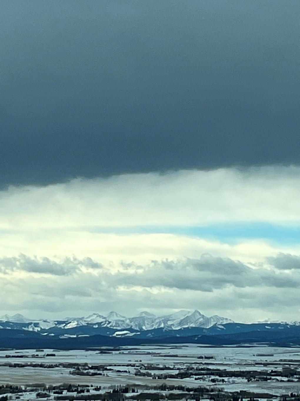 Chinook arch in southern Alberta on Nov. 22. (courtesy viewer Kym)
Submit your weather photos here to see them featured in our article, and perhaps even as the pic of the day during our News at Six. You can also share to my Facebook page, on Twitter, or to our Instagram at @CTVCalgaryWeather.
Shopping Trends
The Shopping Trends team is independent of the journalists at CTV News. We may earn a commission when you use our links to shop. Read about us.


CTVNews.ca Top Stories

B.C. carjacking suspect sped across U.S. border before arrest, police say
Authorities have arrested a suspect who allegedly carjacked a pickup truck in B.C.'s Lower Mainland then sped across the U.S. border, triggering a massive police response.
Alberta premier says federal border plan coming Monday
The much-anticipated federal plan to address issues at the Canada-U.S. border will be unveiled on Monday according to Alberta Premier Danielle Smith.
Ottawa has sold its stake in Air Canada: sources
Two senior federal government sources have confirmed to CTV News that the federal government has sold its stake in Air Canada. During the COVID-19 pandemic in 2021, the government purchased a six per cent stake in the airline for $500 million as part of a bailout package.
Premiers disagree on whether Canada should cut off energy supply to U.S. if Trump moves ahead with tariffs
Some of Canada's premiers appeared to disagree with Ontario Premier Doug Ford on his approach to retaliatory measures, less than a day after he threatened to cut off the province's energy supply to the U.S. if president-elect Donald Trump follows through on his threat of punishing tariffs.
'Very concerned': Crews search B.C. ski resort for missing man
Police and rescue crews are searching for a man who was last seen boarding a ski lift at B.C.'s Sun Peaks Resort Tuesday.
Man who set fires inside Calgary's municipal building lost testicle during arrest: ASIRT
Two Calgary police officers have been cleared of any wrongdoing in an incident that saw a suspect lose a testicle after being shot with an anti-riot weapon.
Blizzard warning shuts down large parts of midwestern Ontario
It was a day to stay home, if you could, across much of midwestern Ontario due to weather.
Travis Vader, killer of Lyle and Marie McCann, denied day parole
The man who killed an Alberta couple in 2010 has been denied day parole.
She took a DNA test for fun. Police used it to charge her grandmother with murder in a cold case
According to court documents, detectives reopened the cold case in 2017 and then worked with a forensics company to extract DNA from Baby Garnet's partial femur, before sending the results to Identifinders International.
Edmonton
-

College remembers slain security guard as documents show criminal history of pair charged
A vigil was held Thursday at Norquest College for a security guard who was killed at an Edmonton apartment building last Friday.
-
Travis Vader, killer of Lyle and Marie McCann, denied day parole
The man who killed an Alberta couple in 2010 has been denied day parole.
-
Police warn public about a text messaging scam circulating in Alberta
Vermilion RCMP issued a warning to the public about a text message scam involving speeding violation tickets.
Lethbridge
-

Lethbridge Fire and EMS offering safety reminders ahead of holiday season
As the holidays quickly approach, Lethbridge Fire and Emergency Services (LFES) is putting out a reminder to celebrate safely this year.
-
Lethbridge man caught in possession of illegal drugs twice in 2 days: police
Lethbridge police say a 58-year-old man has been charged with drug trafficking offences twice within a 48-hour period.
-
Hurricanes continue winning ways at home, defeating Blades 2-1
The Hurricanes continued to ride a hot streak at home Wednesday, as they edged the Blades 2-1 in a game played at VisitLethbridge.com Arena.
Vancouver
-
B.C. carjacking suspect sped across U.S. border before arrest, police say
Authorities have arrested a suspect who allegedly carjacked a pickup truck in B.C.'s Lower Mainland then sped across the U.S. border, triggering a massive police response.
-
Eby says 'nothing's off the table' in responding to Trump's tariff threats
From the merry-looking set of a movie, where he was making a film-industry-related announcement, Premier David Eby came out firing with B.C.'s potential response to massive tarrifs threatened by Donald Trump.
-
5 injured after multi-vehicle crash on Hwy. 99 between Surrey, Delta
Five people were hospitalized following a serious multi-vehicle crash that closed Highway 99 between Surrey and Delta during the Thursday evening rush hour.
Vancouver Island
-

Eby says 'nothing's off the table' in responding to Trump's tariff threats
From the merry-looking set of a movie, where he was making a film-industry-related announcement, Premier David Eby came out firing with B.C.'s potential response to massive tarrifs threatened by Donald Trump.
-
Team Canada athletes counting down to Invictus Games in Vancouver and Whistler
In recent weeks, BC Place has hosted the Grey Cup and the biggest musical act on the planet – and soon, the opening ceremonies of the Invictus Games will take over the venue.
-
Video shows B.C. commercial truck driver stumbling through roadside sobriety check
New video sent to CTV News shows a commercial truck driver struggling to stay on his feet during a sobriety check Monday afternoon in Port Coquitlam after allegedly crashing into multiple parked cars.
Saskatoon
-

'Gong show': Sask. emergency patients move into ambulatory unit at St. Paul's Hospital
The emergency department at St. Paul's Hospital is so full its turning to the ambulatory unit.
-
'Not even our project': Saskatoon city spends more than $5 million on homelessness with no provincial commitment
Saskatoon City Council held a special meeting Thursday morning to address homelessness years into the future, but frustration grew throughout the meeting as the province was absent from the conversation.
-
Prince Albert police release photo of suspect in family/grandparent scam
The Prince Albert Police Service (PAPS) is releasing a photo of a person of interest in connection with a family/grandparent emergency scam following multiple reports.
Regina
-

'We want to see some good hockey': Assiniboia rolls out red carpet for Red Wings after rink closure
The Weyburn Red Wings are carrying on with their season, despite their hometown rink being temporarily shuttered, thanks to the generosity of those in Assiniboia, Sask.
-
Sask. premier says collaboration needed to tackle border security and avoid Trump tariffs
Saskatchewan Premier Scott Moe says an “all hands-on-deck approach” is needed to address border security concerns to avoid U.S. President-elect Donald Trump's tariff threat on products from Canada and Mexico.
-
Yorkton patient speaks out on city losing four doctors
A cattle farmer near Yorkton has spoken out about the shortage of doctors in the Yorkton region after losing her family physician in the area.
Toronto
-

Man facing charges after allegedly stealing car with dog inside in Toronto
A 39-year-old man is facing charges after allegedly stealing a vehicle with a dog inside it in Toronto on Wednesday.
-
Car captured on video driving wrong way in downtown Toronto, striking multiple vehicles
An elderly woman is in custody after a car was captured on video driving the wrong way in downtown Toronto Thursday, leaving behind a trail of damaged vehicles.
-
'That's fine,' Trump says in response to Premier Ford’s threat to cut off energy supply to U.S.
President-elect Donald Trump is not worried about Ontario Premier Doug Ford’s threat to cut off energy supply to the U.S. as retaliation to the proposed 25 per cent tariff on Canadian goods.
Montreal
-

Judge to set trial date in February in Robert Miller sex crimes case
A judge has adjourned the criminal case against Montreal billionaire Robert Miller after he was recently charged with new sexual offences involving a minor.
-
'We're seeing over 30 refusals every day': Montreal shelters struggling with winter weather underway
With winter underway, women's homeless shelter Chez Doris has announced it will resume its 24/7 service and raise funds for a new day shelter at the historic Fulford building.
-
Rust scores hat trick, Penguins strike six times in third to win 9-2 over Canadiens
Bryan Rust scored a hat trick and added an assist as the Pittsburgh Penguins crushed the Montreal Canadiens 9-2 on Thursday night.
Atlantic
-

Bass River, N.S., bridge partially collapses
A bridge in Bass River, N.S., partially collapsed on Wednesday. The wooden structure was under construction when one side gave way and fell into the river.
-
N.S. Premier Tim Houston reveals new cabinet, department names
The new cabinet for the Nova Scotia government will have its swearing-in ceremony Thursday afternoon.
-
'It felt like someone had really long nails': Owl attacks Halifax runner on trail
An owl attacked a runner in a Halifax trail.
Winnipeg
-

'I am a little anxious': Winnipeggers weigh in on proposed 5.95 per cent property tax hike
Winnipeggers are mulling over a nearly six per cent property tax hike.
-
Manitoba premier eyes list of possible retaliatory measures for U.S. tariffs
Manitoba Premier Wab Kinew says his government is preparing a list of potential retaliatory measures if the United States government imposes new tariffs on Canadian goods.
-
'Many lives can be saved': One year since Earl Moberg disappeared, calls for change continue
One year since Earl Moberg disappeared in Winnipeg, his family’s calls for changes to the silver alert system are on their way to Parliament Hill.
Ottawa
-
 NEW THIS MORNING
NEW THIS MORNING Today is the CTV Morning Live Holiday Helpers Food Drive. Here's how you can help
Today is the annual CTV Morning Live Holiday Helpers Food Drive to support the Ottawa Food Bank and ensure that no family goes hungry this holiday season.
-
NEW THIS MORNING
NEW THIS MORNING What's happening in Ottawa this weekend: Dec. 13-15
Christmas market season continues, holiday lights light up several attractions and the Senators, 67's and Black Bears are home. CTVNewsOttawa.ca looks at things to do in Ottawa and eastern Ontario this weekend.
-
BREAKING
BREAKING Eastbound Hwy. 417 closed near Arnprior after serious crash
Ontario Provincial Police have closed Highway 417 at Campbell Drive near Arnprior after a serious crash on Thursday afternoon.
Northern Ontario
-

Elliot Lake fire crews continue to battle massive apartment fire
Fire crews continue to battle an apartment building fire on Hirshhorn Avenue in Elliot Lake. Damage is extensive.
-
Northern Ont. bank employee taken to hospital with serious injuries after shooting
An employee at Northern Credit Union in Wawa, Ont., was taken to hospital with serious injuries after a shooter entered the branch and opened fire Thursday morning, the financial institution said in a statement.
-
Stabbing in wooded area of Sudbury results in attempted murder charge
Sudbury police have charged a man, 28, with attempted murder after a stabbing in wooded area off Leslie Street on Wednesday night.
Barrie
-

What police want you to know about a new sophisticated scam
It’s no longer just phone calls or emails — fraudsters could now show up at your front door.
-
Six arrested, loaded gun seized in Barrie drug bust
Six people were arrested on Wednesday afternoon following an investigation into suspected drug trafficking in the north end of Barrie.
-
Shotgun fired, tv stolen in home invasion, suspects at large
Provincial police are seeking suspects allegedly involved in an armed home invasion and robbery in Everett over the weekend.
Kitchener
-

Guelph’s bike repair lady finally catches a ‘brake’
A Guelph woman who fought city hall and won in a bid to keep operating a bicycle repair service out of her garage, which benefits charity, scored another victory Thursday night.
-
Conestoga College offering 160 employees early retirement
Conestoga College is looking to cut costs by offering 160 of its full-time employees an early retirement package.
-
Premier proposing legislation to clear encampments and target illegal drug use
Ontario Premier Doug Ford is proposing stronger legislation for breaking up encampments.
London
-

London Ont.'s funny billboard guys take serious stand against renovictions
A pair of real estate brokers are backing their words with time and money, after committing to retain a tenant living in a deeply affordable apartment above their future office space.
-
Man and woman charged following armed robbery in Exeter: OPP
According to police, on Saturday afternoon just after 1:00 p.m., the pair entered a residence on Carling Street and assaulted and stole money from the people inside.
-
40 to 80 cm of snow in some areas: Blizzard and snow squall warnings up across the region
Blizzard and snow squall warnings have rolled across much of southern Ontario – with up to 15 centimeters expected today, and blowing snow reducing visibility on roadways.
Windsor
-

Windsor could get a helicopter to clamp down on border: Premier Ford
A lot of chatter in Queen's Park today concerning relations between Canada and the United States – from border security to fighting tariffs with more tariffs.
-
Shots fired in South Windsor, one injured
An investigation is underway after the Windsor Police Service said multiple shots were fired at a group of people in South Windsor.
-
'You lose that sense of hope': Windsorite describes what it is like to be forced from a homeless encampment
A Windsorite is describing what it is like to be forced from a homeless encampment.


