Active weather expected for Friday, followed by a warm weekend
Summer officially began on Thursday and for the first time in five days, it actually felt like summer with a high of 20 C!
The weekend will get even warmer but before we talk about that, we need to talk about the active weather in store for southern Alberta on Friday.
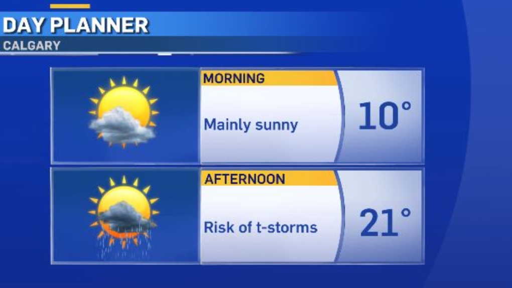
Lots of sunshine is expected for the morning and early afternoon but thunderstorms are likely in Calgary after 4 p.m.
Cells will develop in the foothills in the afternoon and track toward the east.
We should have all the ingredients in place to get some severe thunderstorms.
This means gusts at 90 km/h or greater, hail two centimetres or larger, heavy downpours and even rotation is possible, which could lead to funnel clouds and tornadoes.
The areas where the storms are likely to intensify to the severe level are Calgary and south along Highway 2.
Then, these cells will track east throughout the supper hours.
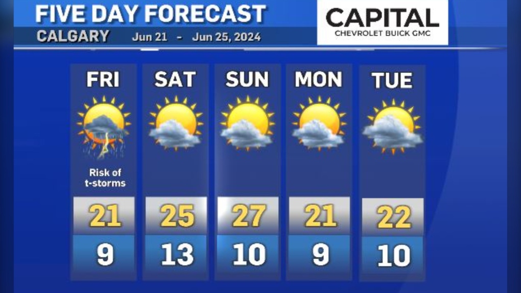
A ridge of high pressure will build in for the weekend.
This promotes sinking air, stability, sunshine and hotter temperatures.


CTVNews.ca Top Stories

DEVELOPING
DEVELOPING Israel launches strikes on military targets in Iran, escalating Mideast wars
Israel launched airstrikes early Saturday on what it described as military targets in Iran in retaliation for a ballistic missile assault Oct. 1, officials said. There was no immediate information on damage in the Islamic Republic.
DEVELOPING
DEVELOPING Scotiabank confirms outage for mobile, online banking
Scotiabank has confirmed outages affecting mobile and online banking services, according to a statement published to its X account.
'I did everything I could': Canada Post driver recounts helping save woman from fiery Tesla crash
Canada Post driver Rick Harper recounts how he and others helped save a woman from a Tesla that caught fire after crashing into a guardrail on Lake Shore Boulevard.
An abrupt goodbye to a guerilla goldfish aquarium beneath a leaky Brooklyn fire hydrant
A makeshift aquarium that popped up this summer in a puddle beneath a leaky fire hydrant in New York City has been paved over, to the dismay of neighbours who turned the area into a hangout spot and goldfish shrine.
Climate change breaks heat records across Canada this summer
Human-caused climate change made almost all of Canada’s heat waves hotter and more likely, Environment and Climate Change Canada said in an announcement Friday.
Mother who beat and starved her 5-year-old son to death sentenced to over 50 years in prison
A New Hampshire woman was sentenced Friday to 53 years to life in prison in the death of her 5-year-old son, who was beaten, starved and exposed to drugs before his 19-pound body was found buried in a Massachusetts park in 2021.
'Get away from your inner circle': Liberal MP 'shocked' PM didn't take more time to reflect on calls to resign
Longtime Liberal MP Wayne Long says Prime Minister Justin Trudeau should give more weight to the views of his backbenchers in determining his future leading the Party, rather than relying on those in his immediate orbit.
Mom and child jumped from a window to escape a Las Vegas fire that killed 2 children and 2 adults
Two adults and two children were found dead in the charred rubble of a house fire after a mother and another child jumped from a third-floor window to escape flames in a southwest Las Vegas neighborhood, authorities said.
Russian actors made fake video depicting mail-in ballots for Trump being destroyed, FBI says
Russian actors made a widely circulated video falsely depicting mail-in ballots for Donald Trump being destroyed in Pennsylvania, U.S. officials said Friday.
Shopping Trends
The Shopping Trends team is independent of the journalists at CTV News. We may earn a commission when you use our links to shop. Read about us.


Edmonton
-

Former Alberta teacher sentenced to 4 years for sexually assaulting student
A former Alberta teacher has been sentenced to four years for sexually abusing a student.
-
2nd person charged in stabbing death of man found on Edmonton sidewalk
A second person has been charged in connection with the death of a man in the Kingsway area earlier this year.
-
'We’re spending about $14K per month': Food banks looking to stock shelves ahead of holiday rush
Students are feeling the pinch, and the University of Alberta Food Bank is looking to refill the shelves ahead of what is expected to be another record year for demand.
Lethbridge
-

City of Lethbridge and local post-secondaries discuss how to keep graduates in the city
About 15,000 students are enrolled at Lethbridge’s post-secondary schools, and now the city is working with those schools to try to find ways to get them s to stick around a while.
-
Lethbridge police, Interfaith Food Bank set to host trick-or-treating-inspired events
With Halloween less than a week away, organizations in Lethbridge are preparing to get in on the trick-or-treating fun.
-
Lethbridge council to present water conservation policy as it aims to consume 20 per cent less by 2030
The City of Lethbridge is bringing forward a water conservation policy, the first of its kind for the city.
Vancouver
-

B.C. election: Final count begins Saturday, will add roughly 66K votes to total, Elections BC says
The final count of ballots in the 2024 B.C. election begins Saturday, with more than 66,000 mail-in and absentee votes potentially yet to be counted across the province's 93 electoral districts.
-
Real estate agent fined $14K for allowing husband to provide licensed services
A B.C. real estate agent who allowed strangers to access a home without licensed supervision, and then lied when questioned about it later, is facing a $14,000 fine and a six-month suspension.
-
Condo owners looking to cash in on Taylor Swift mania in Vancouver
The countdown to the arrival of Taylor Swift’s Eras Tour is on, with three dates planned in Vancouver this December - and some condo owners are looking to cash in on the fan frenzy.
Vancouver Island
-
B.C. election: Final count begins Saturday, will add roughly 66K votes to total, Elections BC says
The final count of ballots in the 2024 B.C. election begins Saturday, with more than 66,000 mail-in and absentee votes potentially yet to be counted across the province's 93 electoral districts.
-
Island's first trauma-informed, Indigenous-specific child-care centre opens in Colwood
Hulitan Early Years Centre is a brand new, 48-seat childhood learning centre in Colwood. It was built to support Indigenous children throughout the capital region.
-
Police seek witnesses to fatal hit-and-run near Nanaimo, B.C.
Mounties in Nanaimo are asking the public for help as they investigate a fatal hit-and-run collision that killed a man southeast of the city Thursday evening.
Saskatoon
-

'I'm very, very scared for his health': Sask. mom worried child might die before surgery
A Saskatchewan woman is worried her child might die before receiving life-saving surgery and tests as he sits on the province's surgical waitlist.
-
Saskatchewan RCMP release names of two arrested after widespread search
The Saskatchewan RCMP is releasing the names of two suspects arrested on Thursday for a violent vehicle theft that triggered a widespread police search.
-
Saskatchewan forensic investigators unable to identify remains in autopsy
Police have still not confirmed the identity of a body discovered in Prince Albert last week.
Regina
-

Riders prepare for unique season finale that could result in bye to West Final
Saturday will mark the end of the CFL regular season, and the Saskatchewan Roughriders will have their eyes on Winnipeg’s matchup versus Montreal to know if they have a chance of clinching the West Division.
-
City of Yorkton launches new housing incentive program
With an attempt to address the shortage of housing available in the community, the City of Yorkton has started a housing incentive program where new builders will receive a 50 per cent rebate on residential lots, and a full tax exemption for five years.
-
How will ballots be counted for the Saskatchewan election?
As the final day of voting for the Saskatchewan election inches closer, voters may be wondering when official winners will be declared.
Toronto
-

'I did everything I could': Canada Post driver recounts helping save woman from fiery Tesla crash
Canada Post driver Rick Harper recounts how he and others helped save a woman from a Tesla that caught fire after crashing into a guardrail on Lake Shore Boulevard.
-
Second suspect sought in shooting death of 37-year-old Brampton man: Toronto police
Police say they are searching for a second suspect wanted in connection with the murder of a 37-year-old Brampton man who was shot to death in Toronto last month.
-
DEVELOPING
DEVELOPING Scotiabank confirms outage for mobile, online banking
Scotiabank has confirmed outages affecting mobile and online banking services, according to a statement published to its X account.
Montreal
-

'Intolerable': Educators at Quebec youth detention centre accused of having sex with minors
Quebec's social services minister says he's outraged by reports that educators at a detention centre for youth in Montreal had sexual relations with minor detainees — and that one of the employees allegedly had a baby with a teenage resident.
-
Minors charged after 4 teens stabbed outside Montreal high school
Two minors were in court Friday to face charges after four teenagers were stabbed outside a Montreal high school.
-
DEVELOPING
DEVELOPING Israel launches strikes on military targets in Iran, escalating Mideast wars
Israel launched airstrikes early Saturday on what it described as military targets in Iran in retaliation for a ballistic missile assault Oct. 1, officials said. There was no immediate information on damage in the Islamic Republic.
Atlantic
-

'We cannot thank you enough': GoFundMe for family of Halifax Walmart employee hits $190K
The GoFundMe page for the family of an employee found dead at a Halifax Walmart last weekend has paused donations after almost $200,000 was raised in roughly 24 hours.
-
Nova Scotia teen charged in connection with threats against eastern Ontario Catholic high school
Ontario Provincial Police (OPP) say a 14-year-old boy from Bridgewater, N.S. is facing several charges in connection with threats made against a Catholic high school in eastern Ontario.
-
Halifax tent encampment one week away from eviction day
Eviction day is one week away and the number of tents in the median of University Avenue in Halifax is steadily decreasing ahead of the city-imposed deadline.
Winnipeg
-

Sleeping U of M student attacked in her dorm, Winnipeg police searching for suspect
Winnipeg police are looking for a suspect after a woman's dorm room was broken into at the U of M and she was assaulted.
-
Repairs to The Forks historic rail bridge could cost $10M
Repairs to the historic 110-year-old rail bridge at The Forks could come with a multi-million dollar price tag.
-
Mechanical condition of car not a factor in crash that killed 59-year-old man: Manitoba RCMP
Manitoba RCMP are providing an update to a crash on Highway 1 that killed one person on Wednesday.
Ottawa
-

Nova Scotia teen charged in connection with threats against eastern Ontario Catholic high school
Ontario Provincial Police (OPP) say a 14-year-old boy from Bridgewater, N.S. is facing several charges in connection with threats made against a Catholic high school in eastern Ontario.
-
Ottawa police deem death of a woman in south end park a femicide
A Montreal man is charged with first-degree murder in connection to the stabbing death of a woman at a park in Ottawa’s south end on Thursday.
-
One person found dead in Perth, Ont., OPP investigating
Ontario Provincial Police are investigating after a body was found in Perth, Ont. Friday afternoon.
Northern Ontario
-

Cochrane plans to roll out $10 lot sale within two months
The Town of Cochrane plans to roll out its $10-lot program in a month or two.
-
Dumping raw sewage, leaving trailers in the same spot leads to $7K in fines west of Timmins
Two people – one from Timmins, the other from Kapuskasing -- have been fined more than $7,000 for camping violations, including empty septic tanks directly onto the ground.
-
New annual funding aims to improve Indigenous learning in Ontario
The federal government is spending a significant amount of money to improve Indigenous student learning across Ontario.
Barrie
-

High school soccer game called off after 'verbal and physical exchanges'
Several students have been banned from being spectators at school sporting events, and others suspended from school, after verbal and physical exchanges at a high school soccer game.
-
South Simcoe police veteran facing discreditable conduct charges amid sex assault allegation
A 15-year veteran officer with the South Simcoe Police Service has been charged with discreditable conduct following an allegation of sexual assault.
-
Dozens of dead birds found along Georgian Bay shorelines
Residents are reporting troubling scenes along a stretch of Georgian Bay’s shoreline, where several dead birds have been found.
Kitchener
-

'Violence is not good': UW stabber apologizes at end of sentencing hearing
Geovanny Villalba-Aleman, the man who stabbed three people in a gender studies class at the University of Waterloo, says he ‘acted dumb’.
-
Erick Buhr cross-examined on the stand at his second-degree murder trial
All the evidence has now been called at the trial of Erick Buhr, who has pleaded not guilty to second degree murder in the death of his grandmother, Viola Erb.
-
Smoke seen billowing from waste management site in Waterloo
Residents spotted smoke coming from a waste management site in Waterloo on Friday afternoon.
London
-

Overdoses due to substance distributed for free prompts warning from London police
London police have issued a warning to the public following an increased number of overdoses in the area of Queens Avenue and Adelaide Street North.
-
Two suspects wanted in assault and stolen vehicle investigation
On Wednesday afternoon just before 4:30 p.m., a man and woman entered a business in the area of Oxford Street East and Highbury Avenue North.
-
Worlds collide: Why encampments may be setting up closer to residential neighbourhoods
A new staff report calls for homeless encampments to be allowed even closer to residential neighbourhoods, reducing the buffer zone from 100 metres to 25 metres.
Windsor
-

Windsor police investigating suspicious death
The Windsor Police Service is investigating a suspicious death in south-central Windsor.
-
'They were very special to us': Harrow school memorializes students and mother tragically killed
A Harrow school is memorializing two students and their mother, who were tragically killed in June.
-
New bridge means new opportunities for Windsor-Detroit cyclists
The Gordie Howe International Bridge will serve as a new crossing for vehicles, but many walkers and cyclists are also excited about the opportunity to access the U.S. in a different way.


