Another foggy start, with cooler temps expected to persist Thursday
Once again southern and central Alberta sit under a fog advisory as dense fog and near-zero visibility impact the region.
A freezing drizzle advisory was also issued for Calgary, and communities north, south, east and west, including Cochrane, Airdrie, Red Deer, Okotoks, Brooks, Drumheller and Medicine Hat.
 A freezing drizzle advisory issued for portions of southern Alberta early Thursday.
Freezing drizzle can produce icy conditions as supercooled water droplets falling through air temperatures below 0 C, freeze on contact with surfaces and form a layer of ice that can be difficult to detect.
In their 4:57 a.m. bulletin, Environment and Climate Change Canada noted the freezing drizzle “is expected to taper off near noon [Thursday].”
As of 8 a.m. Thursday, highway conditions around Alberta were worse than they were on Wednesday with many sections of the southeastern portion of the province showing icy and snow-covered routes.
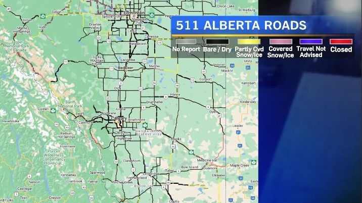
The 511 Alberta cameras outside of Calgary were still showing fog by 8:30 a.m.

The Colorado Low sitting over the Dakotas is bringing snow into southwestern Saskatchewan and southeastern Alberta. That, coupled with a ridge of high pressure over northern British Columbia has created a stagnant pattern through portions of Alberta which is trapped in between the two systems.
As a result, daytime highs in Calgary will remain cooler for the next couple of days with overnight lows expected to be slightly warmer than average. Without a change in the weather patterns fog and freezing drizzle are possible again on Friday morning.

For the latest weather warnings from Environment and Climate Change Canada click here, and driving conditions from 511 Alberta can be found here.


CTVNews.ca Top Stories
$500K-worth of elvers seized at Toronto airport
Fishery and border service officers seized more than 100 kilograms of unauthorized elvers at the Toronto Pearson International Airport on Wednesday.
Banking mogul suing government after intelligence leaks leave him shut out of Canadian economy
Chinese Canadian banking mogul Shenglin Xian has launched a $300 million lawsuit against the federal government. It’s a means to find the source of intelligence leaks which Xian says has cost him his livelihood.
Woman with liver failure rejected for a transplant after medical review highlights alcohol use
For nearly three months, Amanda Huska has been in an Ontario hospital, part of it on life support, because of severe liver failure. Her history of alcohol use is getting in the way of her only potential treatment: a liver transplant.
His SUV was stolen on Montreal's South Shore. Then he got a $156 parking ticket
A couple is frustrated after their SUV was stolen from Montreal's South Shore in March and they received a parking ticket for the same vehicle last week.
Evacuation orders lifted in Fort McMurray Saturday as rain dampens wildfire activity
Residents of Fort of McMurray who were displaced over wildfire concerns were told to return home Saturday.
Member of Israel's War Cabinet says he'll quit June 8 unless there's new war plan
Benny Gantz, a centrist member of Israel’s three-member War Cabinet, threatened on Saturday to resign from the government if it doesn't adopt a new plan in three weeks' time for the war in Gaza.
To plant or not to plant? Gardening tips for May long weekend
May long weekend is finally here, and with the extra time off you may be getting the itch to head out to your garden and plant. However, the old debate whether you should plant now, or wait, is still ever-present.
Serial sexual offender linked to unsolved 1970s homicides of four Calgary girls, women
An investigation into unsolved historical homicides from the 1970s has linked the deaths of two girls and two young women in and around Calgary to a now-deceased serial offender.
Scottie Scheffler, from the course to jail and back: What to know about his PGA Championship arrest
Two-time Masters champion Scottie Scheffler was arrested after police say he dragged an officer while trying to get around the scene of a fatal accident Friday ahead of the second round of the PGA Championship.
Shopping Trends
The Shopping Trends team is independent of the journalists at CTV News. We may earn a commission when you use our links to shop. Read about us.


Edmonton
-
Woman slashes attackers with seatbelt cutter in Edmonton road rage incident Friday: EPS
Police are looking for three people after a road rage incident in south Edmonton on Friday morning.
-
Evacuation orders lifted in Fort McMurray Saturday as rain dampens wildfire activity
Residents of Fort of McMurray who were displaced over wildfire concerns were told to return home Saturday.
-
Oilers to start Stuart Skinner in net for must-win Game 6 vs. Canucks
The Edmonton Oilers will start Stuart Skinner in net Saturday for a must-win Game 6 of their second-round playoff series against the Vancouver Canucks.
Lethbridge
-

Lethbridge home prices continue to rise
The average home price in Lethbridge has jumped 11.6 per cent in the last year. A home in Lethbridge now costs just over $374,000 on average. That's according to the latest data from the Alberta Real Estate Association.
-
Downtown Lethbridge lawlessness task force seeing positive progress
Lethbridge has been working to address lawlessness in the city’s downtown over the past six months.
-
Patios and parklets program returns to downtown Lethbridge for 2024
It's just about patio season in Lethbridge, and the city is once again rolling out its annual patios and parklets program.
Vancouver
-

Pattullo Bridge no longer closing Saturday night after construction work finishes early
The Pattullo Bridge will not be closing overnight Saturday after construction work that was scheduled to shut it down northbound finished early.
-
Police investigating after fisherman stabbed in Mission, B.C.
Mounties in Mission are asking the public for help identifying the suspect in a stabbing that took place in the city Thursday night.
-
Long weekend snow in the forecast on B.C. mountain passes
The May long weekend is traditionally the unofficial start of summer, but it looked a lot more like winter on some of the province's highways Friday.
Vancouver Island
-

Doctors, patients want options to reduce dialysis waste adding to climate change
Dr. Caroline Stigant, a nephrologist at Royal Jubilee Hospital in Victoria and a leading advocate for sustainable kidney care, said each hemodialysis treatment uses up to 500 litres of water and large amounts of energy.
-
Police remain tight-lipped one year after crash killed municipal worker near Victoria
One year after an allegedly reckless driver careened into a municipal park east of Victoria, killing a 52-year-old husband and father of two young children, there are few answers about what led to the crash and no criminal charges have been forwarded to prosecutors.
-
'It's pure joy!': B.C. pilot takes 96-year-old grandma on meaningful flight
“Good to see you,” Ryan Godard says before giving his 96-year-old grandma a big hug and walking her towards the small airplane. “Let’s get you prepped.”
Saskatoon
-
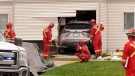
'The car was half inside my children's room': Car crashes into Saskatoon apartment building
Firefighters responded to a scene on the 300 Block of Herold Road Friday morning after a car collided with an apartment building.
-
Firefighters on scene of structure blaze in Saskatoon
Firefighters are on the scene of a structure blaze in the 100 Block Avenue Q South.
-
Sask. doctor says physicians aren’t being paid correctly under province’s new billing system
A Saskatoon family doctor says the province’s new billing system is a disaster.
Regina
-

U of R students, staff coordinate in support of ending violence in Gaza, West Bank
A group of students along with faculty members from the University of Regina (U of R) held a peaceful sit-in to show their support for the people of Gaza and the West Bank on Friday.
-
Sask. Teachers' Federation recommending tentative deal with province to its members
The Saskatchewan Teachers' Federation (STF) and province announced that a tentative agreement had been reached on Friday afternoon, with the STF recommending and endorsing the potential deal to teachers.
-
B.C. study tracks breaths of killer whales using stunning drone video
The use of drones has helped researchers track the breathing patterns of killer whales off B.C.'s coast, and the videos offer a stunning glimpse of the majestic creatures diving and surfacing.
Toronto
-

Small plane crashes just outside Toronto
A small plane crashed with two people onboard northeast of Toronto on Saturday morning.
-
Man fatally shot in car outside house in Brampton
A man was fatally shot in a car outside of a house in Brampton Saturday morning, police say.
-
Police release photo of suspect who allegedly smashed windows, doors of North York synagogue
Toronto police have released a photo of an individual suspected of smashing windows and glass doors of a North York synagogue on Friday, which is being investigated as a hate-motivated incident.
Montreal
-

Online obituary business from Quebec City catching flak for posting unauthorized death notices
Some within the funeral home and mortuary services industries in Quebec say they are frustrated with an online obituary site that publishes death notices from public information posted on the internet. They claim the site is doing so without consent from the families.
-
Man killed in Montreal's St. Henri neighbourhood in first of two stabbings overnight
Police are investigating the 12th homicide on the Island of Montreal after a man was stabbed and killed on Saturday morning.
-
CF Montreal 'grass guy' has pro tips for the perfect lawn
CF Montreal sports field manager James Johnson said 'no-mow May' is a great place to start to develop a healthy and pristine lawn for the summer.
Atlantic
-

'You can really start to feel the excitement': Unofficial start to summer kicks off in the Maritimes
Maritimers and tourists are gearing up for the unofficial start to summer as the May Long Weekend gets underway.
-
Celebration of life for Arthur Irving held in Saint John
Friends and family of Arthur Irving gathered in his Saint John home Saturday to celebrate his life after the businesses titan passed away Monday at the age of 93.
-
Laura Lee Langley named new president of the Atlantic Canada Opportunities Agency
A former high-profile Nova Scotia civil servant has been appointed as head of a well-known federal agency.
Winnipeg
-

WFPS deals with a pair of structure fires and a gas leak to start May long weekend
Winnipeg fire crews had to deal with multiple fires and a gas leak between Friday night and Saturday morning.
-
To plant or not to plant? Gardening tips for May long weekend
May long weekend is finally here, and with the extra time off you may be getting the itch to head out to your garden and plant. However, the old debate whether you should plant now, or wait, is still ever-present.
-
Teen arrested for using bear spray during convenience store robbery: Winnipeg police
A 17-year-old has been arrested after police say he used a can of bear spray while trying to rob a store on Thursday.
Ottawa
-

Suspicious package stops VIA Rail service in Kingston, Ont.
VIA Rail says its trains are experiencing delays of up to three hours in the Kingston, Ont. area, as police investigate a suspicious package near the railway tracks.
-
St.Laurent Station remains closed Saturday, here's the alternative
Though the rail service Saturday will launch as planned, St-Laurent Station remains closed after finding evidence of corrosion and concrete delamination during a regular inspection on the ceiling tiles on Friday, OC Transpo says.
-
The eight most expensive homes for sale in Ottawa this spring
Ottawa's ultra luxury housing market is blooming like the tulips this spring, with a significant increase in the number of homes sold worth more than $2 million.
Northern Ontario
-

Woman with liver failure rejected for a transplant after medical review highlights alcohol use
For nearly three months, Amanda Huska has been in an Ontario hospital, part of it on life support, because of severe liver failure. Her history of alcohol use is getting in the way of her only potential treatment: a liver transplant.
-
Northern Ont. man jailed 10 days for fishing violations
A Sault Ste. Marie man has been jailed for 10 days for failing to comply with a court order banning him from fishing.
-
Box tree moths have infested Ontario and experts say more are coming. Here's what to do to protect your garden
An invasive moth species is on the rise in Canada and, if you've planted a certain shrub, it could stand to ruin your garden.
Barrie
-
OPP investigating crash in Minden Hills
OPP is investigating a crash that happened in Minden Hills on Saturday.
-
Slo-Pitch fundraiser for Special Olympics returns to Barrie
Hundreds participated in Saturday's 'Slo-Pitch for Special Olympics' softball tournament.
-
Two people found dead in Bradford home
South Simcoe Police are investigating two people who were found dead in a Bradford home Friday evening.
Kitchener
-

Impaired driver sentenced to 7 years after double-fatal Cambridge crash
A man who killed two people in a drunk driving crash was sentenced Friday to seven years behind bars.
-
Remembering the ‘perfect storm’ that was 1974 Cambridge flood
The Grand River burst its banks on May 17, 1974 and water spilled onto several city streets - a day Cambridge, and residents, will never forget.
-
Police investigating suspicious fire in Kitchener
Waterloo regional police are investigating a suspicious fire in Kitchener in the Courtland Avenue East area.
London
-

Serious injuries sustained in crash near Listowel
Perth County OPP responded to a report of a motor vehicle collision in the Municipality of North Perth late Friday afternoon.
-
CTV News London's top stories from this week
In case you missed it, CTV News London has compiled all the top local stories from this week into one video for your convenience.
-
Small plane crashes just outside Toronto
A small plane crashed with two people onboard northeast of Toronto on Saturday morning.
Windsor
-

Pro-Palestinian protestor laments UWindsor president's absence from recent meeting amid ongoing campus encampment
Protestors who have set up an encampment on the University of Windsor campus say the school's president was absent from a recent meeting with school administration.
-
Small plane crashes just outside Toronto
A small plane crashed with two people onboard northeast of Toronto on Saturday morning.
-
CKPS kept busy with multiple break and enter investigations
Chatham-Kent police responded to three separate break and enters Friday.


