
AS IT HAPPENED
Layers and rain cover will take a higher priority than tank tops and flip-flops this long weekend.
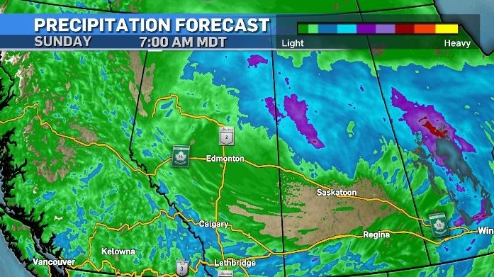
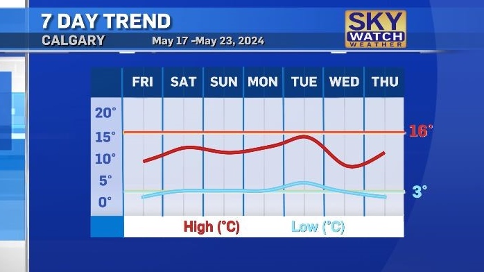
Daytime highs are expected to be between 10 C and 13 C in Calgary with scattered showers and strong wind from Friday until Monday.
Portions of Calgary experienced a rain/snow mix early Friday, a scenario that may repeat on Saturday morning.
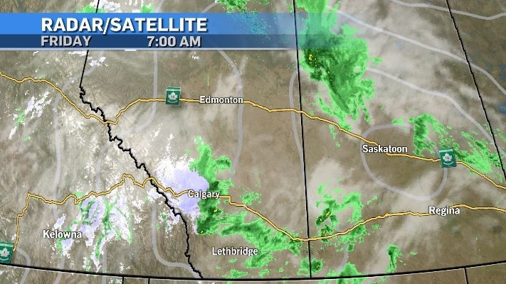
Mixed precipitation is possible in higher elevations – especially overnight, and this likelihood prompted a special weather statement for highways in the B.C. Interior with Environment and Climate Change Canada explaining, “colder air along with precipitation means the mountain passes are seeing some snow now. The precipitation is going to change to rain during the day, and likely to return back to flurries tonight and into Saturday morning.”
The national weather agency notes between two to five centimetres of snow is possible in these overnight periods. With warmer surface temperatures and increased traffic there is little concern over icing, however slushy wet snow can create traction hazards and impact visibility.
Rain in northern Alberta has had a positive impact on the wildfires in terms of holding the fires and also on air quality as rain is pulling particulate to the surface. As such, as of 7:30 a.m. Friday air quality advisories have been lifted for the area.
Wind will be strong in central Alberta on Friday and also in southern Alberta. Convective activity (thunderstorms) are possible on Saturday, but if they occur in Calgary they will be isolated.
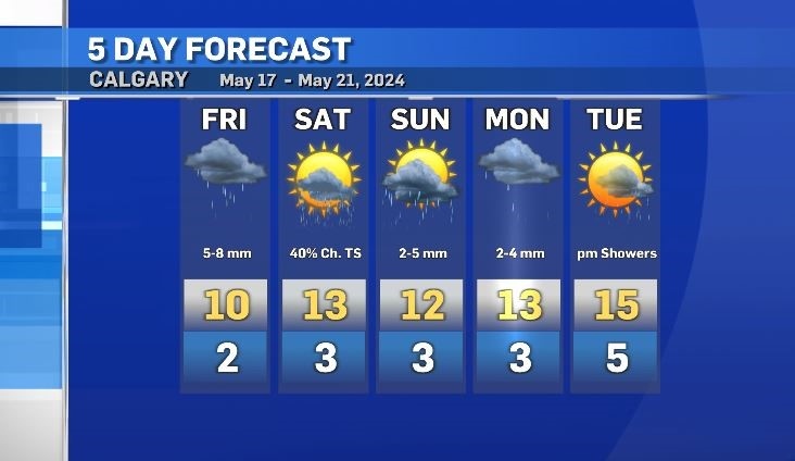
Overnight temperatures will sit closer to freezing for the city of Calgary with many communities benefitting from the urban heat island effect. Some areas could dip below 0 C, with this chance increasing outside of the city.
One of two wildfires threatening Jasper National Park reached the townsite Wednesday night and caused 'significant loss.'
Alberta has called in the Canadian Armed Forces to help assist with the worsening wildfire situation in the province.
U.S. President Joe Biden on Wednesday delivered a solemn call to voters to defend the country's democracy as he laid out in an Oval Office address his decision to drop his bid for reelection and throw his support behind Vice President Kamala Harris.
Staff at a Barrie child care centre say they are frustrated by what they call a local MPP's inadequate response after a car crashed through a window in one of the toddler rooms.
The North American Aerospace Defence Command (Norad) intercepted two Russian and two Chinese bombers flying near Alaska Wednesday in what appears to be the first time the two countries have been intercepted while operating together.
An analyst and an assistant coach with Canada Soccer are being removed from the Canadian Olympic Team and 'sent home immediately,' according to the Canadian Olympic Committee.
After a handful of Australian water polo players tested positive for COVID-19 this week, questions have emerged around how the spread of the disease will be mitigated at the Summer Olympic Games in Paris.
A B.C. man who was hired to help a non-profit build a food hub but instead spent the money on personal expenses – including travel, restaurants, booze and cannabis – has been ordered to pay more than $120,000 in damages.
Two people are dead and two others suffered serious injuries following a shooting that police have described as a 'gun battle' outside a plaza in Scarborough, Ont. early Wednesday morning.
The Shopping Trends team is independent of the journalists at CTV News. We may earn a commission when you use our links to shop. Read about us.
One of two wildfires threatening Jasper National Park reached the townsite Wednesday night and caused 'significant loss.'
One of two raging, wind-whipped fires menacing Jasper, Alta., roared into town Wednesday night and began burning buildings.
A number of weather warnings were issued in central Alberta Wednesday night.

Lethbridge has been no stranger to extreme heat over the last couple weeks.
To break down barriers, an adaptive water skiing clinic was held for those with mental and physical disabilities on Tuesday evening...
In a heated courtroom exchange, a man accused of conspiring to murder police at the 2022 Coutts, Alta., blockade rejected accusations he and others brought weapons and body armour to the barricade to start a war.

Vancouver city council has voted to allow natural gas for heating and hot water in new construction.
T.J. Walkem, along with more than 80 of his cows, has spent the last few days desperately trying to evade the out-of-control Shetland Creek wildfire.
Environment Canada has recorded a whopping 80,007 lightning flashes in British Columbia from Sunday through Tuesday, and the count continues on Wednesday for what could be a record-breaking stretch.

Police on Vancouver Island are investigating three sexual assaults by strangers that were reported in the past week, though there is no indication the attacks are connected.
A B.C. man who was hired to help a non-profit build a food hub but instead spent the money on personal expenses – including travel, restaurants, booze and cannabis – has been ordered to pay more than $120,000 in damages.
A wildfire burning out of control on Vancouver Island continued to spread Wednesday as the provincial wildfire service assigned more resources to try to contain the blaze.

Prince Albert is grieving the loss of one of its most beloved neighbours and community champions.
As people get out and enjoy the many lakes in our province this summer, those who take care of the waterways are warning about dangerous invasive species that’s a growing threat in Saskatchewan.
A seven-year-old Saskatoon girl is dealing with the aftermath from her lemonade stand being robbed by two teenage boys on Monday.

Drivers passing through Moose Jaw can expect some delays following a crash near Highway 1.
Residents in Regina and Moose Jaw will soon have better tasting water.
With Regina facing another round of hot temperatures, in addition to smoke lingering in the air, it is a particularly difficult time for those experiencing homelessness.

The day after the doors of the Ontario Science Centre closed to the public on the grounds that its roof was failing and unsafe, the centre’s management made an exception to allow a wedding and reception on its grounds.
One person is dead after a collision in Mississauga Wednesday afternoon.
Back-to-back RBI singles with two out from Justin Turner and Daulton Varsho were enough to spark a four-run eighth inning and push the Toronto Blue Jays to a 6-3 win against the Tampa Bay Rays on Wednesday.

Maude Charron will carry the Canadian flag during Friday's Olympic opening ceremony in Paris. The athlete from Rimouski will also be defending her Olympic gold medal in weightlifting.
Montreal police are investigating after electronic message boards at two road construction sites in Montreal displayed pro-Palestinian political slogans Wednesday morning instead of usual traffic alerts.
Montreal's transit authority said a water main break disrupted service on part of the metro's orange line during the afternoon commute Wednesday.

Showers along with a risk of thunderstorms will return to the Maritimes on Thursday as a cold front approaches from the west.
A judge has ruled that a stash of cryptocurrency belonging to a convicted Nova Scotia murderer means he won't be receiving free legal aid for an appeal.
Two people are facing drug smuggling-related charges after border officers seized 140 pounds of suspected cannabis at the Halifax Stanfield International Airport on Monday.

The Winnipeg Police Service (WPS) is executing a search warrant at a North End property on Wednesday to look for evidence linked to a missing person case from 2021.
An elementary school in Thompson, Man., has gone up in flames on Wednesday.
A saving grace for a dwindling Winnipeg church has come in the form of Winnipeg Jets owner Mark Chipman and Juno-award-winning folk duo The Brothers Landreth.

A series of weather watches were issued across Ottawa and eastern Ontario, as severe storms moved through the area Wednesday.
The Olympics begin Friday, but it's been an embarrassing debut for the Canada’s women's soccer team who are now embroiled in a major scandal.
With the dark cloud of higher interest rates looming overhead, many small, local construction companies have been waiting for interest rates to drop before taking on risk and kickstarting projects in and around the capital.

An analyst and an assistant coach with Canada Soccer are being removed from the Canadian Olympic Team and 'sent home immediately,' according to the Canadian Olympic Committee.
With soccer growing in popularity in Sudbury, some with experience in the sport are with confusion and disappointment to the recent news out of the Olympics.
Staff at a Barrie child care centre say they are frustrated by what they call a local MPP's inadequate response after a car crashed through a window in one of the toddler rooms.

Staff at a Barrie child care centre say they are frustrated by what they call a local MPP's inadequate response after a car crashed through a window in one of the toddler rooms.
Barrie police are using a utility vehicle along the city's waterfront this summer to help officers get to challenging locations and increase their presence throughout the busy area.
The Bank of Canada lowered its key interest rate to 4.5 per cent, as those looking to renew or buy a mortgage watched closely.

A police constable in Guelph, Ont. pleaded guilty Wednesday to discreditable conduct – for a second time.
A Cambridge woman explains why she blames the GRCA for a flood that damaged her home and forced her family to flee in a canoe.
The Waterloo Regional Police Service (WRPS) is searching for a 16-year-old they say escaped a security custody facility in Wilmot Township.

17-year-old Breanna Broadfoot, who will be honoured with a vigil on Wednesday night, had allegedly previously been attacked by her partner, residing in the same home where she later received fatal injuries.
Nobody likes a loud and aggressive driver – but one such driver caught the attention of the wrong police officer when they revved their engine at a red light in Mitchell in early July.
On Tuesday, a majority of council rejected a recommendation by the Civic Works Committee that would have reduced speed limits by 10 km/hr in school zones along arterial roads during periods when students are usually present.

The residents of Spago Crescent in South Windsor are open to change.
This weekend, the town of Amherstburg will be a car-lover's dreamland come true.
Politicians came together at the Gordie Howe International Bridge Wednesday afternoon to celebrate its deck connection.


