Fog advisories issued for all of southern Alberta due to near-zero visibility
Dense fog settled over southern Alberta late Tuesday and remains in place early Wednesday.
A widespread fog advisory was issued from Environment and Climate Change Canada (ECCC) due to near-zero visibility in some areas, with a slight improvement expected by the afternoon.
As of 7:30 a.m., the fog advisory covered the entire southern border of the province, extending north along the foothills to Canmore, up the QEII to north of Olds, and along the Saskatchewan border to north of Coronation.
The national weather agency cautioned fog will only be part of the problem, saying “areas of freezing drizzle are also expected, which will make surfaces slippery. Some areas may see fog and freezing drizzle redevelop tonight.“
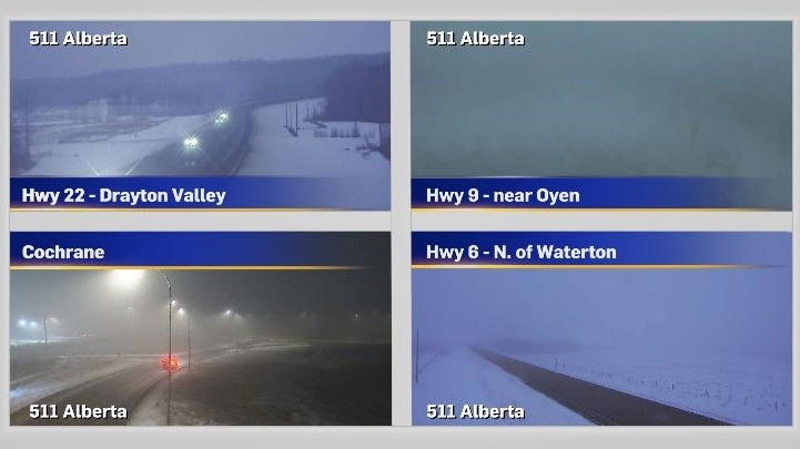
As of 7:55 a.m., foggy conditions were prevalent on the 511 Alberta cameras.
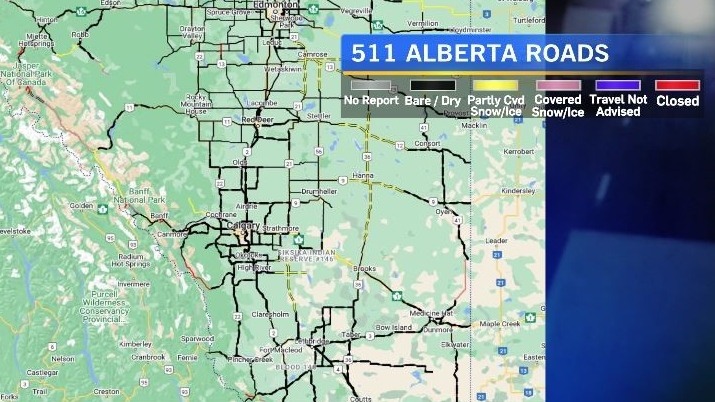
Road conditions on the 511 Alberta map Wednesday morning appeared to show improving road conditions throughout southern Alberta following the weekend snowfall, but current conditions are expected to impact commuters, with ECCC advising, “Travel is expected to be hazardous due to reduced visibility in some locations.”
South of the border a series of low pressure systems are expected to amalgamate and become a potent Colorado Low. Snowfall in southern Saskatchewan will morph into a sharp rain-snow line that will cross through Manitoba and into Ontario over the next 24-48 hours, creating dangerous road conditions in those provinces with strong winds complicating the effects of local precipitation.
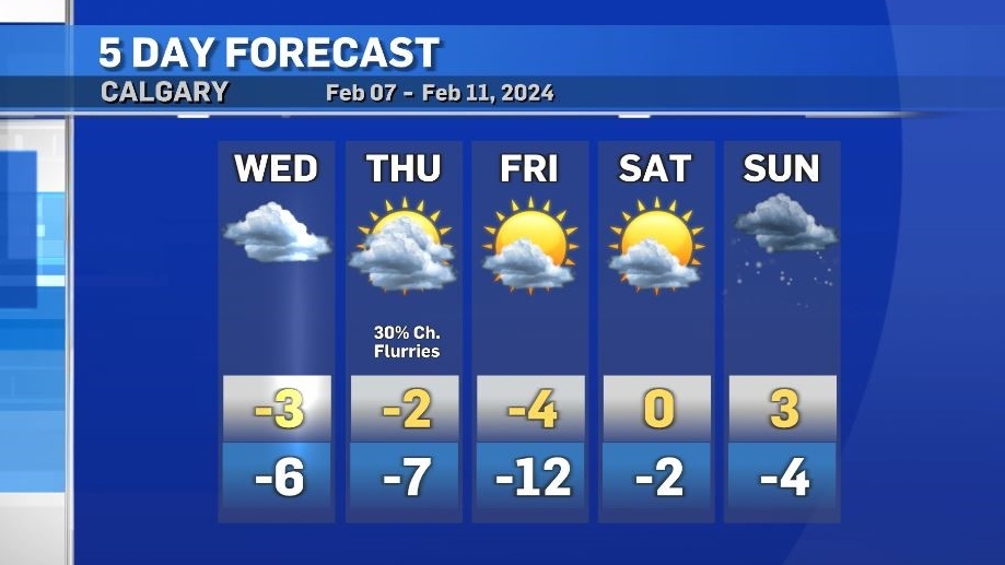
Meanwhile southern Alberta will settle into a pattern of slightly cooler conditions for the end of the week and slightly warmer conditions by the weekend. Daytime highs are expected to sit at or above freezing from Saturday until Monday. The average daytime high for Calgary for this time of year is -1 C.


CTVNews.ca Top Stories

America votes: How the election could impact the Canada-U.S. border
While America's southern border remains a hot button issue on the campaign trail, the result of the U.S. election in November could also impact the northern frontier with Canada, which remains the longest undefended border in the world.
NEW THIS MORNING
NEW THIS MORNING This Ottawa photo radar camera issued 200 tickets a day over the summer
New data shows the automated speed enforcement camera on King Edward Avenue, between Bolton Street and St. Patrick Street, issued 6,337 speeding tickets in August, the highest number of tickets issued by Ottawa's 40 photo radar cameras.
Couche Tard, On the Run parent firms challenge Health Canada nicotine pouch rules
Convenience store firms that operate thousands of outlets across Canada are taking the federal government to court to overturn regulations that restrict the sale of nicotine pouches to pharmacies.
Investigation underway after 2 workers die inside silo
The Ministry of Labour is investigating a workplace incident that claimed the lives of two people in Georgian Bluffs, south of Owen Sound.
The Menendez brothers case is not the only one that's been affected by a true crime documentary
Being an armchair detective has turned into an American obsession, fueled by an abundance of true-crime content in podcasts and television series. But some of those projects have sparked actual legal developments.
Tax rebate: Canadians with low to modest incomes to receive payment
Canadians who are eligible for a GST/HST tax credit can expect their final payment of the year on Friday.
Homeowners hit by Hurricane Helene face the grim task of rebuilding without flood insurance
A week after Hurricane Helene overwhelmed the Southeastern U.S., homeowners hit the hardest are grappling with how they could possibly pay for the flood damage from one of the deadliest storms to hit the mainland in recent history.
B.C. Lions snuff out Calgary Stampeders playoff hopes with 32-15 win
The loss that extinguished the Calgary Stampeders playoff dreams Friday provided some deja vu for head coach Dave Dickenson.
Lost your smell during a bout of COVID? Local researchers are working to reverse that.
Bruzzese came down with COVID-19 in February 2023, and received her injection at the end of March. “Being able to recognize smells is something we take for granted, until you can’t.”
Shopping Trends
The Shopping Trends team is independent of the journalists at CTV News. We may earn a commission when you use our links to shop. Read about us.


Edmonton
-

Woman dies in east Edmonton collision with building on 118 Avenue
A 79-year-old woman is dead after the vehicle she was driving crashed into an east Edmonton building late Friday afternoon.
-
Edmonton mayor's letter to province asks for fair treatment in next year's budget
A letter from Edmonton's mayor to the Alberta government detailing the city's fiscal wishlist ahead of next year's budget calls for fair treatment for the capital city, something several city councillors say isn't already happening.
-
New TV series shows Oilers star McDavid 'like we've never really seen before'
A new docu-series that reveals what life is like for National Hockey League players on and off the ice during the playoffs is now out.
Lethbridge
-

Driver airlifted following serious crash in Taber, Alta.
A person was airlifted to hospital following a serious crash in Taber, Alta., on Friday morning. Taber RCMP responded to the scene on Highway 864 around 10:30 a.m., for a crash involving an SUV and a semi-truck.
-
'Equity for everyone': Lethbridge Polytechnic launches accessibility micro-credential
To enhance inclusivity at Lethbridge Polytechnic, the institution has launched a new accessibility micro-credential.
-
WestJet makes changes at Lethbridge Airport
WestJet has changed its operations at the Lethbridge Airport, and it means there's now only a single daily flight from Lethbridge to Calgary, down from three flights a day, as offered previously.
Vancouver
-

Parents plead for more help for youth after 13-year-old B.C. boy dies of drug overdose
Chayton Point loved to dance. Just ask his mom.
-
Doubled tax, more child care, new tech jobs: B.C. election campaign wraps second week
As the provincial election campaign reaches the halfway mark, the party leaders made pitches to voters on bread-and-butter issues: housing, child care and jobs.
-
'You will see a significant and visible police presence': VPD planning for protests for Oct. 7
Vancouver police have deployed extra resources in anticipation of multiple protests planned for Oct. 7.
Vancouver Island
-

Teachers' union wants education focus in B.C.'s 2024 election
We haven't heard the candidates talk much about education during B.C.'s 2024 election campaign, but the teachers' union is trying to put the spotlight on that issue.
-
Missing B.C. climber died from fall on Mount Baker, medical examiner says
The body of a British Columbia mountain climber has been located and recovered after the 39-year-old man was reported missing during a solo climb on Washington state's Mount Baker earlier this week.
-
Early morning earthquakes rattle B.C.
Many British Columbians were shaken awake early Friday morning when an earthquake struck in the Strait of Georgia, about 18 kilometres southwest of Tsawwassen.
Saskatoon
-

Private school funding draws attention during STF education forum
The Saskatchewan Teachers' Federation hosted a virtual election forum on education Thursday evening, giving candidates in the provincial election a chance to share their thoughts and answer questions on issues teachers find most important.
-
Sask. man pleads guilty in U.S. after unknowingly providing videos of men raping toddlers to FBI agent
A Saskatchewan man living in the United States has pleaded guilty to possessing child pornography after he unknowingly provided disturbing videos to an FBI agent he thought was a pedophile.
-
Saskatoon police arrest homeless person at scene of encampment fire under University Bridge
Saskatoon police arrested a homeless person at the scene of an encampment underneath the University Bridge on Friday morning.
Regina
-

Sask. man pleads guilty in U.S. after unknowingly providing videos of men raping toddlers to FBI agent
A Saskatchewan man living in the United States has pleaded guilty to possessing child pornography after he unknowingly provided disturbing videos to an FBI agent he thought was a pedophile.
-
Judge reserves decision in challenge of SaskPower natural gas expansion
A group of climate activists is challenging SaskPower's move towards natural gas, arguing it violates their Charter rights.
-
Regina kids facing mobility issues gifted toy cars through Go Baby Go program
Regina kids facing mobility issues were gifted toy cars through the Go Baby Go program.
Toronto
-

Two pedestrians taken to hospital after Vaughan crash, one person in custody
Two pedestrians have been taken to hospital with unknown injuries after an early-morning collision in Vaughan.
-
'Unacceptable:' Toronto councillor calls for public inquiry into Eglinton Crosstown delays
A Toronto city councillor is calling for a public inquiry into the construction of the delayed and over-budget Eglinton Crosstown LRT.
-
America votes: How the election could impact the Canada-U.S. border
While America's southern border remains a hot button issue on the campaign trail, the result of the U.S. election in November could also impact the northern frontier with Canada, which remains the longest undefended border in the world.
Montreal
-

2 dead after fire rips through historic building in Old Montreal
At least two people are dead and others are injured after a fire ripped through a century-old building in Old Montreal early Friday morning, sources told Noovo Info.
-
Police boosting presence in Montreal ahead of Oct. 7 anniversary of Israel-Hamas war
Montreal police say they are increasing their presence across the city ahead of the one-year anniversary of the Oct. 7 start of the Israel-Hamas war.
-
Language watchdog tells Gatineau, Que. cafe to write Instagram posts in French
The owner of a Gatineau, Que. café says it's 'silly' that Quebec's language watchdog is telling the business to write its Instagram posts in French.
Atlantic
-

Youth pleads guilty to manslaughter in death of P.E.I. teen Tyson MacDonald
A teen charged with the murder of another teen on Prince Edward Island last year has pleaded guilty to a lesser charge of manslaughter.
-
'Pattern' of violence, threats against federal fisheries officers in Maritimes: DFO
The federal Fisheries Department says it is concerned about a "pattern" of violence and threats toward its enforcement officers after two tense incidents off southwestern Nova Scotia last month.
-
'Believe that you belong': Sport sets girls up for success, but gender barriers remain
According to the Canadian Women & Sport's 2022 Rally Report, 76 per cent of girls who participate in sports believe it helps build confidence and enhances their mental health. While those benefits are important for all children, the organization's CEO says, right now, girls have less access.
Winnipeg
-

'Great fun in this': Giant roadside attractions across Manitoba highlighted online
It’s 1998. Google was just born, and dial-up was the primary way to connect to the Internet. New sites were being developed daily on any number of topics, from recipes to shopping. David Yanciw, however, was thinking big - big things, that is.
-
Oliveira leads Winnipeg Blue Bombers to 31-10 road win over Ticats
Brady Oliveira and the Winnipeg Blue Bombers continue to roll along. Oliveira ran for a season-high 147 yards and a touchdown to power Winnipeg past the Hamilton Tiger-Cats 31-10 on Friday night.
-
Manitoba doctors getting sick of sick notes: report
A new report from Doctors Manitoba is calling for major changes to the way sick notes are issued in Manitoba, saying they are a waste of time for doctors and employers.
Ottawa
-
 NEW THIS MORNING
NEW THIS MORNING This Ottawa photo radar camera issued 200 tickets a day over the summer
New data shows the automated speed enforcement camera on King Edward Avenue, between Bolton Street and St. Patrick Street, issued 6,337 speeding tickets in August, the highest number of tickets issued by Ottawa's 40 photo radar cameras.
-
Language watchdog tells Gatineau, Que. cafe to write Instagram posts in French
The owner of a Gatineau, Que. café says it's 'silly' that Quebec's language watchdog is telling the business to write its Instagram posts in French.
-
Here's how much gas prices in Ottawa are set to go up Saturday
Gas prices in Ottawa are set to rise this weekend after a slight uptick overnight.
Northern Ontario
-

Canadian musician Jacob Hoggard found not guilty of sexual assault
Canadian musician Jacob Hoggard has been found not guilty of sexually assaulting a young woman in northeastern Ontario eight years ago. The former Hedley frontman had pleaded not guilty to sexual assault.
-
Sudbury suspect assaults police one day after being freed on bail
Two police officers in Greater Sudbury required medical attention for injuries they received arresting a man for the second time in just two days.
-
Police arrest Toronto woman in connection with three recent homicides
Police have arrested a Toronto woman in connection with three recent homicides and investigators say that they believe two of the victims may have been 'randomly targeted.'
Barrie
-

Grieving mother calls for added safety measures at Ontario beach after drowning death of son
A woman whose son died last month while at a Penetanguishene, Ont. beach with another family member wants to see safety increased at the beach.
-
Investigation underway after 2 workers die inside silo
The Ministry of Labour is investigating a workplace incident that claimed the lives of two people in Georgian Bluffs, south of Owen Sound.
-
Highway 400 crash near Waubaushene under investigation
Provincial police are investigating a collision along Highway 400 in Tay Township Friday afternoon.
Kitchener
-

Impaired driver charged after car crashes in Kitchener home: WRPS
Police have laid charges after a car crashed into the side of a Kitchener home early Friday morning.
-
New era for former musicians of the K-W Symphony
The K-W Symphony may have played their last concert but the musicians who made up the ensemble aren’t ready for their curtain call.
-
Cambridge, Ont. mother who killed daughter to be sent to mental health hospital
Melissa Duff-Shore, a Cambridge, Ont. woman who killed her daughter in 2020, has been ordered to a forensic hospital in St. Thomas.
London
-

Lost your smell during a bout of COVID? Local researchers are working to reverse that.
Bruzzese came down with COVID-19 in February 2023, and received her injection at the end of March. “Being able to recognize smells is something we take for granted, until you can’t.”
-
CTV News London’s top stories from this week
In case you missed it, CTV News London has gathered all of the top local stories from this week into one video for your convenience.
-
'Nice and crisp' fall morning on Saturday before cold front moves in
Fall conditions have arrived in the Forest City, with chilly mornings and warmer afternoons in the forecast.
Windsor
-

Ontario man completes week-long marathon spanning 273 km after decade of volunteering
After a decade of volunteering for one of North America’s most punishing ultra marathons, an Ontario man decided to challenge himself by stepping up from the sidelines to become a participant.
-
Collision prompts lane reduction on Wyandotte
A motor vehicle collision at Wyandotte Street East and George Avenue has Windsor police on the scene this morning.
-
CTV News Windsor’s top stories from this week
In case you missed it, CTV News Windsor has compiled all of the top local stories from this week into one video.


