Gradual warmup continues, return to seasonal temperatures next week
On paper, Thursday might look similar to Wednesday, but the day will feel quite different.
The low-pressure system that brought snow to southern Alberta early in the week is continuing to track east along the southern portions of Saskatchewan and Manitoba.
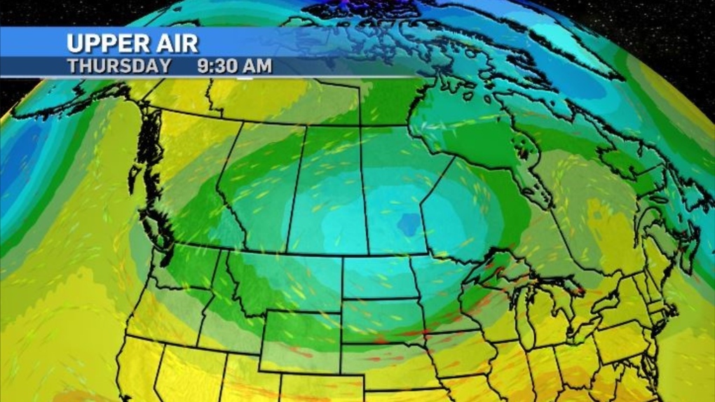
Because the gradient around the low is strong and the system is quite large, the counter-clockwise circulation remains a driver for the conditions in Alberta which sits on the western edge.
Colder air will continue to be pulled in from the north on Thursday and Friday before a pattern change over the weekend. North winds of 20 km/h are likely in Calgary for most of Thursday.
 An upper air map of Canada on April 18, 2024, as of 9:30 a.m. (CTV News)
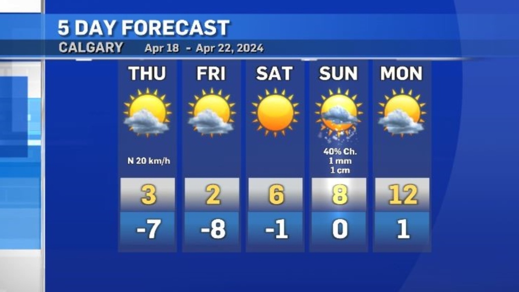
The winds will ease off on Friday, however, daytime highs are expected to sit around 10 degrees below seasonal until Saturday.
A ridge of high pressure will start to move west-to-east through B.C. Saturday, and by Sunday Calgary could experience some brief instability with mixed precipitation possible.
 Calgary five-day forecast for April 18-22, 2024. (CTV News)
Daytime highs for much of southern Alberta will return to seasonal starting Monday and settle a few degrees above seasonal by early next week.
CTVNews.ca Top Stories

DEVELOPING Jasper wildfire burns buildings, while poor air quality forces some fire crews out
A fast-moving wildfire has hit Jasper, Alberta, destroying buildings and chasing some wildland firefighters away with dangerously poor air quality.
Jasper mayor says alert system to be reviewed after message 'glitch'
More than 25,000 people have been displaced from Jasper National Park since wildfires started to threaten the picturesque corner of Alberta Rockies on Monday, but the mayor of its namesake municipality says not everyone received an evacuation alert when it was sent out.
Norad intercepts Russian and Chinese bombers operating together near Alaska in apparent first
The North American Aerospace Defence Command (Norad) intercepted two Russian and two Chinese bombers flying near Alaska Wednesday in what appears to be the first time the two countries have been intercepted while operating together.
Biden explains why he ended re-election bid in Oval Office address
U.S. President Joe Biden on Wednesday delivered a solemn call to voters to defend the country's democracy as he laid out in an Oval Office address his decision to drop his bid for reelection and throw his support behind Vice President Kamala Harris.
Barrie-Innisfil MPP 'blacked-out' and crashed car into window of child care centre
Staff at a Barrie child care centre say they are frustrated by what they call a local MPP's inadequate response after a car crashed through a window in one of the toddler rooms.
Alberta calls in army to assist with wildfire situation
Alberta has called in the Canadian Armed Forces to help assist with the worsening wildfire situation in the province.
2 Canadians being 'sent home immediately,' removed from Olympic team after drone incident
An analyst and an assistant coach with Canada Soccer are being removed from the Canadian Olympic Team and 'sent home immediately,' according to the Canadian Olympic Committee.
An unwelcome attendee has joined the Paris Olympic Games: COVID-19
After a handful of Australian water polo players tested positive for COVID-19 this week, questions have emerged around how the spread of the disease will be mitigated at the Summer Olympic Games in Paris.
Vacations, meals, booze: Contractor used $100K of charity's money for personal expenses, B.C. court finds
A B.C. man who was hired to help a non-profit build a food hub but instead spent the money on personal expenses – including travel, restaurants, booze and cannabis – has been ordered to pay more than $120,000 in damages.


