Jump start to Wednesday as warm air pushes morning temperatures 20 degrees above seasonal
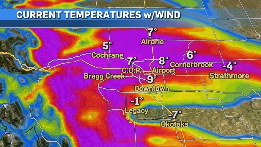
It was an unusual start to the day Wednesday as temperatures at 6:20 a.m. in north Calgary, Airdrie and Cochrane were around 8 C warmer than south Calgary and Okotoks.
Things got even more strange minutes later when temperatures at the airport and downtown jumped up another 7 C.
By 6:30 a.m. warmer westerly winds rapidly elevated temperatures in the north to 9 C while south Calgary and Okotoks were at least 15 C cooler.
By 7 a.m. the temperature west of the city (in Banff) was 20 C colder than at YYC International, and Drumheller was 13 C colder, but the temperature gap was starting to close between north and south Calgary.
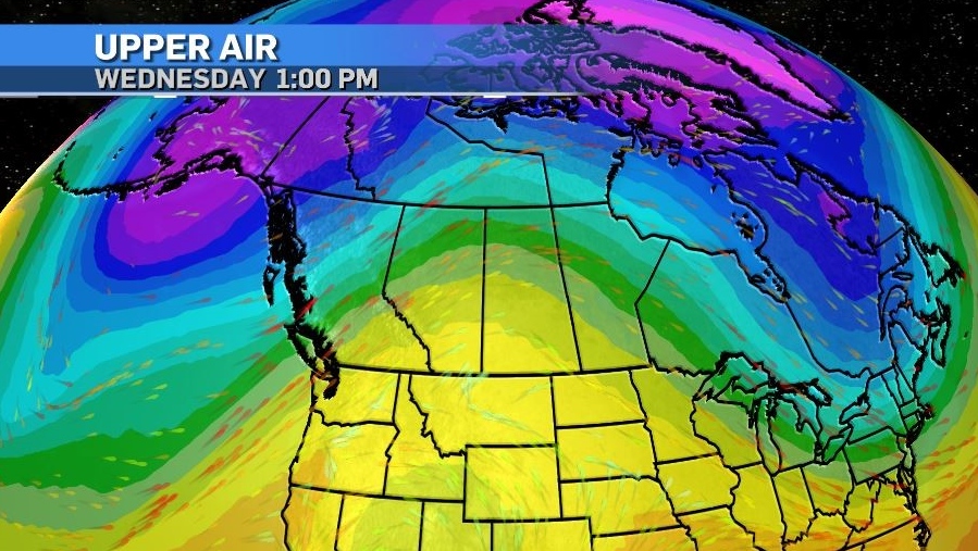
A wide and tall ridge of high pressure extending from California to the Northwest Territories will draw warmer air north Wednesday, boosting temperatures under that ridge. A baroclinic environment will result in windy conditions throughout the day in Alberta with peak gusts coming from the southwest at 40 to 60 kilometres per hour.
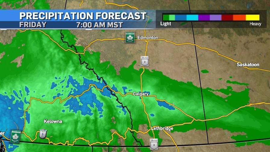
Precipitation will move across the west coast Wednesday before tracking east into southern Alberta early Thursday.
Calgary can expect some rain during the morning commute Thursday, which will transition into scattered, mixed precipitation and then snow.
There should be enough of a southerly influence to keep the bulk of that snow north and east of Calgary, with model agreement on at least one centimetre of accumulation in Calgary.
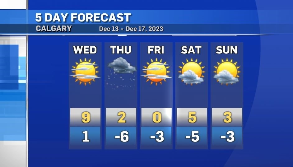
Sunshine will return for the weekend with daytime highs between 3 to 6 C above seasonal and lows between 8 to 10 C above average.


CTVNews.ca Top Stories

Princess Anne sustains injuries and concussion in an 'incident,' Buckingham Palace says
Princess Anne sustained minor injuries and a concussion following an incident on an estate in southwest England, the Buckingham Palace said Monday.
This U.S. company is selling products with human fecal matter to Canadians. What does Health Canada think about it?
The United States Food and Drug Administration (FDA) has issued a warning letter to a company appearing to sell products containing human fecal matter without approval from the agency.
This is what the heat wave was like in one of Canada's densest neighbourhoods
This is what it was like in a Toronto neighbourhood where 30,000 people live during a scorching heat wave.
Lifeguard and 'Pirates of the Caribbean' actor dies after apparent shark attack in Hawaii
A lifeguard and surf instructor – who also appeared in movies including 'Pirates of the Caribbean: On Stranger Tides' and 'Blue Crush' - died Sunday following an apparent shark attack on the North Shore of Ohau, Hawaii, according to officials.
At least 16 dead in a fire at a lithium battery factory in South Korea
A fire at a lithium battery manufacturing factory near South Korea's capital on Monday left at least 16 people dead, seven injured and six missing, officials said.
Is Trump shielded from criminal charges as an ex-president? A nation awaits word from U.S. Supreme Court
In the coming days, the U.S. Supreme Court will confront a perfect storm mostly of its own making: a trio of decisions stemming directly from the Jan. 6, 2021 attack on the U.S. Capitol.
Researchers have found a 'clear genetic trigger for obesity' that applies to some people
Experts have long known there is a genetic component to obesity, and a new study identified one particular gene that may be behind it.
A year ago, her engagement ring vanished at a hospital. She still cherishes the man who gave it to her
When Faye Bauman went to a Florida hospital for surgery last year, she handed her diamond engagement ring to a nurse — and never saw it again. The ring carries profound memories of her late husband and the moment he proposed to her 57 years ago.
Canada to announce tariff plan for Chinese EV, battery imports following U.S., Europe
Finance Minister Chrystia Freeland is expected to announce this morning a plan for potential tariffs to protect Canada's electric vehicle supply chain from unfair Chinese competition.
Shopping Trends
The Shopping Trends team is independent of the journalists at CTV News. We may earn a commission when you use our links to shop. Read about us.


Edmonton
-

Stanley Cup stage set for McDavid, Oilers in final game of roller-coaster season
Connor McDavid and the Edmonton Oilers face the Florida Panthers in Game 7 of the Stanley Cup final Monday — the last hurdle in an improbable journey this season.
-
Nugent-Hopkins plays for the Stanley Cup 13 years to the day since being drafted by the Oilers
When the Edmonton Oilers selected Ryan Nugent-Hopkins with the first pick in the 2011 NHL draft, they had missed the playoffs five consecutive seasons. They did not qualify for seven of his eight first seasons, either.
-
Alberta oil and gas sector exceeded flaring limit in 2023, data shows
A tally by The Canadian Press of Alberta Energy Regulator data shows oil and gas companies in the province flared approximately 754 million cubic metres of natural gas last year, exceeding the annual provincial limit of 670 million cubic metres.
Lethbridge
-

Lethbridge celebrates National Indigenous Peoples Day
National Indigenous People’s Day celebrations got an early start today.
-
Game 6 of Stanley Cup Final gets the big screen treatment in Lethbridge
The resurgence of the Oilers in the NHL finals might be a tough pill for hockey fans in Calgary to swallow, but down in Lethbridge, they’re giving Friday night’s Game 6 the big screen treatment.
-
Hikers injured in Waterton bear attack out of hospital, bear not yet located
Parks officials say two hikers injured in an Alberta bear attack last week are now out of hospital.
Vancouver
-

'Everybody's journey is different': Meet the B.C. man who started Canada’s first vitiligo support group
A B.C. model and actor is helping people with vitiligo come together and share their stories with a support group he co-founded.
-
Motorcyclist dead, pedestrian seriously hurt after pair of crashes in North Vancouver
A motorcyclist has died and a pedestrian was taken to hospital in serious condition after two separate crashes in North Vancouver late Saturday night.
-
No-swim advisory in place for Ambleside beach due to high E. coli levels
Signs went up Saturday at Ambleside Park in West Vancouver warning visitors not to swim or wade in the ocean.
Vancouver Island
-

'We're enraged': Tori Dunn's father shares her heartbreaking final moments
Hundreds of mourners gathered at a vigil in Surrey Bend Regional Park Saturday evening to honour Tori Dunn, who was killed in Surrey, B.C.'s Port Kells neighbourhood last weekend.
-
'Everybody's journey is different': Meet the B.C. man who started Canada’s first vitiligo support group
A B.C. model and actor is helping people with vitiligo come together and share their stories with a support group he co-founded.
-
Basketball ties aside, B.C.'s Macklin Celebrini focused on hockey as NHL draft's presumptive No. 1 pick
Having a father working for the Golden State Warriors and former NBA star Steve Nash for an uncle, college hockey player of the year and the presumptive No. 1 NHL draft pick Macklin Celebrin, likes to think he’s got game.
Saskatoon
-

Tornado watch issued for Saskatoon, funnel clouds reported near Warman
A tornado watch was issued for Saskatoon on Sunday afternoon, with city facilities preparing to close on short notice in the event of an outbreak of severe thunderstorms.
-
Riders remain perfect on season with win over Hamilton
Riders remain perfect on season with win over Hamilton
-
Riders QB Harris exits home opener with apparent leg injury
Riders QB Harris "questionable" to return after suffering hit late in first half vs Hamilton.
Regina
-

Riders remain perfect on season with win over Hamilton
Riders remain perfect on season with win over Hamilton
-
Riders QB Harris exits home opener with apparent leg injury
Riders QB Harris "questionable" to return after suffering hit late in first half vs Hamilton.
-
Roughrider fans gather for 'Party in the Park' to kick off 2024 home opener
The Saskatchewan Roughriders’ home opener for the 2024 season saw fans pack Regina’s Confederation Park prior to kickoff.
Toronto
-

This is what the heat wave was like in one of Canada's densest neighbourhoods
This is what it was like in a Toronto neighbourhood where 30,000 people live during a scorching heat wave.
-
Wrong-way driver charged after collision on Hwy. 400 near Barrie: OPP
Ontario Provincial Police say a man has been charged with impaired driving after travelling the wrong way on Highway 400 near Barrie and colliding with another vehicle.
-
Voters head to polls for Toronto byelection, all eyes on whether Liberals hold seat
Residents of Toronto—St Paul's will head to the polls today to vote for a new member of parliament for their riding, with observers watching to see if the Liberals can hang on to the seat they've held for the last 10 elections.
Montreal
-

Dogs, bicycles allowed on the REM, but there are restrictions
Passengers can now take their four-legged friends, bikes, and other large objects on the Reseau express Metropolitain (REM) under certain restrictions.
-
What's open and closed on Fete Nationale in Montreal
Monday is Fete Nationale (or Saint-Jean-Baptiste Day) in Quebec. Here's a list of what's open and closed in Montreal on June 24.
-
Montreal's 1993 Stanley Cup champions are watching as Edmonton can end Canada's title drought
When members of the 1993 Montreal Canadiens gathered for a reunion to commemorate 30 years since they won the Stanley Cup, they told stories and reminisced about the championship run.
Atlantic
-

Why a yacht docked in Halifax is getting extra attention
Yachts along the Halifax Waterfront often garner attention, but one currently docked has people doing a double take.
-
Dozens gather for rally, counter-rally in downtown Halifax
Dozens of people gathered in Halifax on Sunday to show unity with Israel.
-
A new study shows that 1 year of this kind of exercise yields results 4 years later
Exercise is good, but resistance training with heavy weight is great! That's especially true if you are looking to maintain strength in older age, a new study shows.
Winnipeg
-

Likely tornado, golf ball-sized hail hits during storm in southern Manitoba
Chris Stammers, a meteorologist with ECCC, said it is unconfirmed, but it appears a tornado touched down near Lena, Man. Saturday afternoon.
-
Section of Trans-Canada Highway to be closed starting Monday
A section of the Trans-Canada Highway will be closed to traffic starting Monday.
-
Berry picking season is on schedule, with some farms possibly opening by the long weekend
While it might feel like the berry picking season is behind schedule compared to 2023, one U-pick farm notes everything is going according to plan and farms should be opening soon.
Ottawa
-

Person allegedly posing as Realtor breaks into Ottawa home for fake showing
An Ottawa family is out thousands of dollars after a townhouse they were set to move into turned out to have already been rented.
-
Showers continue in Ottawa on Monday after record-breaking weekend rainfall
Mother Nature continues to soak Ottawa with heavy rain on Monday, one day after record rainfall forced the cancellation of Escapade Music Festival and altered several other events.
-
Ottawa MP apologizes for mailing map to constituents missing a province and a territory
Ottawa Centre MP Yasir Naqvi is apologizing for a mistake on a map of Canada sent to constituents to celebrate Canada Day.
Northern Ontario
-

Dashcam video shows dangerous passing attempt on northern Ont. highway
A stressful moment for several people on a northern Ontario highway was captured on camera last week.
-
This U.S. company is selling products with human fecal matter to Canadians. What does Health Canada think about it?
The United States Food and Drug Administration (FDA) has issued a warning letter to a company appearing to sell products containing human fecal matter without approval from the agency.
-
B.C. First Nations involved in salmon farming demand apology from William Shatner, Ryan Reynolds
A coalition of B.C. First Nations involved in open-net salmon farming have called on Canadian actors William Shatner and Ryan Reynolds to apologize for a profanity-laced video criticizing the wider industry.
Barrie
-

Confirmed tornado near Angus at CFB Borden: National Tornado Project
NTP confirms a tornado touched down in CFB Borden on Saturday.
-
Crash closes Essa Road in Barrie
Serious crash closes Essa Road in Barrie Monday morning.
-
Wildlife, dogs and rabies: Grey-Bruce Public Health alert
Grey-Bruce Public Health says to enjoy wildlife from a safe distance.
Kitchener
-

Most-read stories of the week: Harm reduction vending machine, historic Paris home, air conditioning woes
A vending machine offering harm reduction supplies, a historic home in Paris, Ont. Up for a sale, and a fire tearing through a Simcoe greenhouse nursery round out the most-read stories of the week.
-
5-star forward from Kitchener, Ont., announces commitment to Illinois
Will Riley is jumping into a new chapter of his life.
-
57th annual Multicultural Festival underway in Kitchener
The weekend-long event drew thousands of attendees on Saturday, showcasing the myriad of cultures that contribute to the city’s unique tapestry.
London
-

Overnight fire at vacant building in east London
London fire crews were kept busy overnight after flames broke out at a vacant building on Cabell Street. Multiple crews were on scene at 720 Cabell St. for what was described as a, "Defensive attack with aerial operations."
-
Charges laid after woman found deceased in London apartment
Police said the accused and the victim were known to each other and the accused is being held in custody pending a court appearance.
-
VIDEO
VIDEO Nearly $700,000 in damages, one person sent to hospital after house fire
Crews were called to the scene on Summit Avenue near Oxford Street just after 6:30 a.m. after a caller reported seeing smoke coming from the home.
Windsor
-

Hundreds turn out for vigil in Harrow following deaths of four people
Hundreds of people turned out for a vigil in Harrow on Sunday evening to remember a mother, father and two children who were found dead in a home last week.
-
Down 3-0 is not new for former Windsor Spitfire Adam Henrique
It's winner-take-all tonight in Florida as the Edmonton Oilers try to become the the first Canadian NHL team to win a championship since the early 1990s.
-
Organizers of Mexican Village in Leamington hope Carrousel of Nations festival makes it a tradition
While a Mexican village is traditionally hosted in the WindsorEats food hall as part of the Carrousel of the Nations festival, the 2024 lineup added a second Mexican village in Leamington for the festival's final day.


