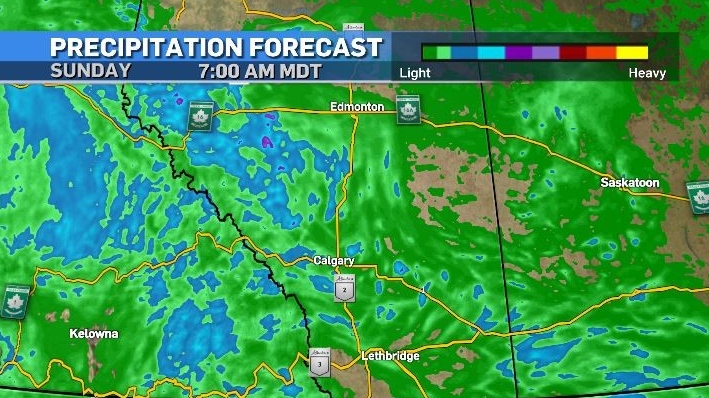
Unsettled start to the weekend with both frost and funnel clouds possible
Friday will be a buffet day of weather – with southern Alberta experiencing fog, sunshine, clouds, rain, thunderstorms, potential funnel clouds, and frost.
Patchy fog is likely early Friday due in part to very light wind, allowing the air just above the surface to become saturated from normal overnight evaporative processes.
A surface trough in eastern British Columbia will help trigger instability along the foothills where afternoon thunderstorms could develop.
Upsloping associated with a frontal system producing active weather in the Midwest and a strong low in the Dakotas could provide wind shear, and all of the above may combine to aid in funnel clouds development along the Trans-Canada corridor later in the day.
As a more regular west-to-east weather pattern returns overnight the skies will be more clear than they have been, and that, along with cooler maximum temperatures and higher soil moisture levels could lead to frost overnight in some communities.
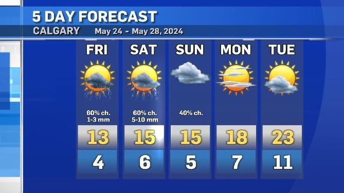
Saturday will be similar to Friday with a risk of showers and thunderstorms expect with higher rainfall totals possible in affected areas.
With rain on Thursday and early Friday Calgary has now had rain on 18 of 24 days in May, or 75% of the days in this month.
May is typically the start of the wet season in Calgary, and the fourth wettest month of the year (June, July and August – in that order – are the months that bring the most precipitation to the area).
As of May 23, Environment and Climate Change Canada reported 50.6 millimetres of rain so far this month, which is still below the 30-year average (56.8 millimetres) for the May monthly total, but on track to exceed that total by month’s end.
Daytime highs will creep closer to seasonal Sunday and Monday, but this will be short-lived.
By Wednesday and Thursday the daytime highs are expected to drop back down to 14 C to 17 C.


CTVNews.ca Top Stories

Smith tells Trudeau Alberta will opt out of federal dental plan
Alberta is opting out of the federal dental plan, the premier told the Canadian government late Tuesday afternoon.
One of Canada's most popular vehicles recalled over transmission issue; 95,000 impacted
One of the country's most popular vehicles is being recalled in Canada due to a transmission issue that may impact tens of thousands of drivers.
WikiLeaks' Assange pleads guilty in deal with U.S. that secures his freedom, ends legal fight
WikiLeaks founder Julian Assange has pleaded guilty to obtaining and publishing U.S. military secrets in a deal with Justice Department prosecutors that secures his liberty and concludes a drawn-out legal saga that raised divisive questions about press freedom and national security.
'We need to regroup,' says Liberal minister and Ontario campaign co-chair in light of byelection loss
A member of Prime Minister Justin Trudeau's cabinet and the party's Ontario co-chair for the next campaign says the Liberals 'need to regroup' after a shocking overnight byelection loss to Pierre Poilievre's Conservatives.
Pre-med students can't take MCAT in Quebec because of Bill 96
Areeba Ahmed says she's always dreamed of becoming a surgeon but her road to the operating room has become a complicated one ever since Quebec's French language law came into effect.
Protesters try to topple Queen Victoria statue near pro-Palestinian encampment in Montreal
Montreal police were called to intervene after protesters attempted to tear down the Queen Victoria statue at Victoria Square.
Cup Noodles serves up notoriously poisonous pufferfish
Pufferfish is regarded as a luxury in Japan and a meal featuring the potentially poisonous delicacy can easily cost up to 20,000 yen (US$125) at high-end restaurants.
'Truly a great British Columbian': Former B.C. premier John Horgan has cancer again
Former B.C. premier and current Canadian ambassador to Germany John Horgan has been diagnosed with cancer for a third time.
New experience in Halifax gets people up close and personal to the ocean's most feared predator
Atlantic Shark Expeditions launched a new shark cage experience which gives brave attendees a chance to get up close and personal with the oceans most feared predator.
Shopping Trends
The Shopping Trends team is independent of the journalists at CTV News. We may earn a commission when you use our links to shop. Read about us.


Edmonton
-
Smith tells Trudeau Alberta will opt out of federal dental plan
Alberta is opting out of the federal dental plan, the premier told the Canadian government late Tuesday afternoon.
-
Canada beats Peru 1-0 at Copa America on David goal, first win over South American team in 24 years
Jonathan David scored in the 74th minute, and Canada beat Peru 1-0 on Tuesday night in the Copa America for its first victory over a South American opponent in 24 years.
-
30,000 free consolation pizzas to be handed out to Oilers fans on Wednesday
Boston Pizza has announced it will deliver free consolation pizza to Oilers fans later this week.
Lethbridge
-

Lethbridge College to be redesignated as polytechnic institution
Lethbridge College will soon become Alberta's latest polytechnic.
-
Town mulling options as Milk River dries up
Before the St. Mary siphon burst, the Milk River's flow rate was approximately 17 and a half cubic metres per second. Monday, it was less than one cubic metre per second.
-
'Just protesting': Accused at Coutts blockade surprised by murder-conspiracy charge
A protester arrested at the border blockade at Coutts, Alta., acted surprised when police told him he was being charged with conspiracy to commit murder.
Vancouver
-

'No fun city': Calls to extend hours at Vancouver beaches
Some Vancouver residents want hours to be extended at city beaches during the summer, criticizing the current bylaw and questioning its enforcement.
-
Transit police campaign targets drivers in Vancouver bus lanes
In a targeted campaign aimed at keeping bus lanes clear for transit vehicles, Metro Vancouver Transit Police have ticketed close to three hundred drivers so far this week.
-
Water quality advisory issued at Sunset Beach
Officials are warning people not to swim or wade at Vancouver’s Sunset Beach due to high bacteria levels in the water.
Vancouver Island
-

Critically endangered Vancouver Island marmots released into the wild
Volunteers carried cages containing very rare furry creatures up Mount Washington on Monday as part of the mission to save Canada’s most endangered mammal.
-
Meet the centenarians: Canada's oldest age group is also its fastest-growing
Vi Roden said she reads an average of 50 books a year, attends history lectures at her local seniors centre, and does yoga twice a week.
-
Pembina, B.C. First Nation give green light to multibillion-dollar LNG project
Pembina Pipeline Corp. and the Haisla First Nation say they have made a final investment decision that will see them go ahead with their proposed US$4-billion Cedar LNG project off the B.C. coast.
Saskatoon
-

'The federal government can't interfere': Sask. will not comply with federal clean electricity regulations
The Government of Saskatchewan announced that it will not comply with the incoming federal clean electricity regulations.
-
Judge rejects Saskatoon mayoral candidate's lawsuit to halt housing accelerator changes
A judge has rejected a Saskatoon mayoral candidate’s bid for a court injunction on zoning changes required for the city to access federal housing accelerator funds.
-
Sask. town gets help from province after destructive weekend storm
The Saskatchewan Public Safety Agency (SPSA) has stepped up to help Carrot River after a destructive storm tore through the community on Sunday evening.
Regina
-

Court hears from victim and mother at trial for Regina teacher accused of sexually exploiting student
High emotions filled a Regina courtroom on the second day of a trial for a former Regina teacher accused of sexually exploiting a female student.
-
Trio from Carnduff, Sask. arrested after drugs, sword seized in traffic stop
A proactive patrol by RCMP officers led to a collection of drug trafficking weapon related charges for three people from Carnduff, Sask.
-
'The federal government can't interfere': Sask. will not comply with federal clean electricity regulations
The Government of Saskatchewan announced that it will not comply with the incoming federal clean electricity regulations.
Toronto
-
 BREAKING
BREAKING Man dies in hospital following stabbing outside Jane Subway Station
A man is dead following a stabbing outside Jane Subway Station, say Toronto police.
-
'Young adult male' killed in Highway 401 collision near Jane Street
A “young adult male” has died following a collision on Highway 401 near Jane Street, say Toronto paramedics.
-
Widow urges judges to overturn declaration police misconduct in her husband's death was 'not serious'
An Ontario widow searching for answers about why the police misconduct in her husband’s death was deemed “not serious” had her day in an Oshawa courtroom on Tuesday as her lawyer urged a panel of judges to require the Ontario Provincial Police hold a hearing in the case.
Montreal
-

Here are the 10 most dangerous intersections for Montreal cyclists
Researchers out of McGill University say there is a critical need for safer cycling infrastructure around certain intersections in Montreal after pinpointing 10 troubling spots in a recent survey.
-
Teen dies after being hit riding e-scooter in Montreal
The 14-year-old boy who was hit by a car in Montreal on Monday has succumbed to his injuries.
-
Alleged Montreal car thief takes off with baby onboard
A seven-month-old baby has been returned to his mother after an alleged thief stole the car he was in.
Atlantic
-

Construction woes continue during peak season in downtown Sydney, N.S.
Street construction in downtown Sydney, N.S., continues into the busy summer months.
-
Man wanted on province-wide arrest warrant arrested: N.S. RCMP
A man wanted on a province-wide arrest warrant in Nova Scotia has been arrested.
-
'It actually makes me very emotional': Sussex residents rejoice over flood mitigation plans
Residents of Sussex, N.B., are rejoicing over the upcoming flood mitigation plans after the town saw much damage in a flood earlier in the year.
Winnipeg
-

Ray St. Germain dead at 83
A well-known Metis musician has died after a years-long battle with Parkinson’s disease.
-
True North asking for extension on decision to purchase Portage Place
The potential purchaser of Portage Place Mall is asking for a 90-day extension for its decision as to whether or not it will buy and redevelop the space.
-
SIU investigating after man fatally shot by OPP in Kenora park; general store 'total loss’ following blaze
Ontario’s Special Investigations Unit (SIU) is investigating after Ontario Provincial Police fatally shot a man in a Kenora, Ont. RV park.
Ottawa
-

Royal Canadian Air Force to hold practice flypast over Ottawa on Wednesday ahead of Canada Day
The Royal Canadian Air Force (RCAF) will hold a flypast over downtown Ottawa and LeBreton Flats on Wednesday, as part of preparations for Canada Day. Aircraft are scheduled to fly over Ottawa between 12 p.m. and 3 p.m.
-
This Ottawa 'fat cat' on a weight loss journey has become a TikTok star
An Ottawa cat has morphed into a TikTok star, as he's slimming down from weighing 43 pounds.
-
Ottawa firefighters battle blaze at south end auto shop
Ottawa firefighters quickly doused a two-alarm blaze at an auto shop in the city's south end Tuesday afternoon. The blaze, which involved vehicles and several tires, was brought under control in about an hour.
Northern Ontario
-

One of Canada's most popular vehicles recalled over transmission issue; 95,000 impacted
One of the country's most popular vehicles is being recalled in Canada due to a transmission issue that may impact tens of thousands of drivers.
-
Another murder-suicide involving intimate partner violence in the Sault
The two bodies found at a Sault Ste. Marie home last month have been deemed a murder-suicide in another tragic case of intimate partner violence in the city, police say.
-
Indigenous burial grounds in northern Ont. to be protected
Ancient burial grounds in the Town of Blind River will soon be marked, and blocked off to the public.
Barrie
-

Former Barrie Colts captain Aaron Ekblad is a Stanley Cup Champion
Barrie's former captain of the Barrie Colts hoists the Stanley Cup after Game 7.
-
Emotions high as family confronts Aurora man convicted of killing his wife
The Aurora man convicted in the death of his wife sat in a courtroom on Tuesday while his family gave emotional victim impact statements ahead of his sentencing.
-
Barrie police seek suspect wanted for possible hate crime
Images of a suspect connected to a possible hate crime were released by Barrie police this week in hopes someone will recognize him.
Kitchener
-

University of Waterloo takes legal action to remove Occupy UW encampment
An ongoing dispute between the University of Waterloo and a pro-Palestinian encampment has turned into a legal battle.
-
Two Ontario players are now Stanley Cup champions
The Florida Panthers have made NHL history and two of their players, who call Ontario home, are now celebrating their first big Stanley Cup win.
-
LCBO customers, businesses in Waterloo Region stock up ahead of possible strike
Customers and businesses in Waterloo Region are stocking up on booze ahead of a possible LCBO strike.
London
-

'Flames 20 feet in the sky': Arson suspected as vacant CN Rail building in St. Thomas catches fire
A vacant building known to be the home of vagrants in St. Thomas has gone up in flames. On Monday night around 11 p.m. the St. Thomas Fire Department was called to an abandoned building belonging to CN Rail at the north end of St. Catharine Street.
-
Council rebuffs Farhi Holdings’ land deal and confirms plan to build new city hall on current property
A last ditch effort to investigate constructing a new city hall building in the heart of downtown London was shot down by a majority of city council.
-
Trees topple in some London neighbourhoods after brief storm blows through
CTV London Meteorologist Julie Atchison said sunshine will start your Tuesday, 'A nice mix of sun and cloud, winds picking up out of the south as we head into the afternoon.'
Windsor
-

Video appears to show vehicle T-boned by school bus at red light
Three students were on a school bus that allegedly ran a red light, colliding with an SUV passing through an intersection on June 19.
-
Windsor business fined $35,000 for 'discrimination and reprisal' of Indigenous transgender woman
The Human Rights Tribunal of Ontario has agreed Mad Wax Windsor Inc. “profoundly affected” a transgender woman for failing to provide a leg wax and taking the story to the media.
-
Body of missing swimmer recovered in Lake Erie
Essex OPP Marine Unit members have recovered the body of a missing swimmer.


