Patio season preview: Warm temperatures dominate weekend forecast
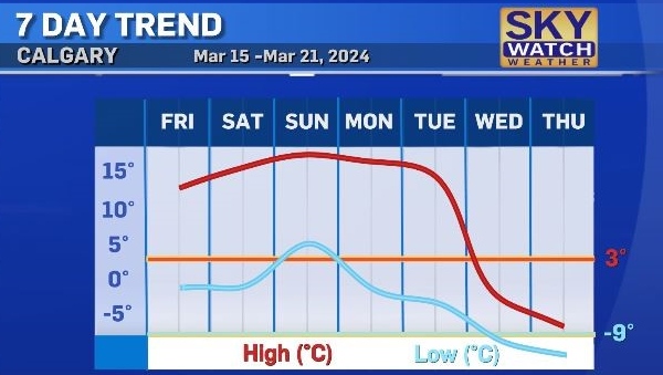
The final weekend of winter is turning out to be the warmest so far this year.
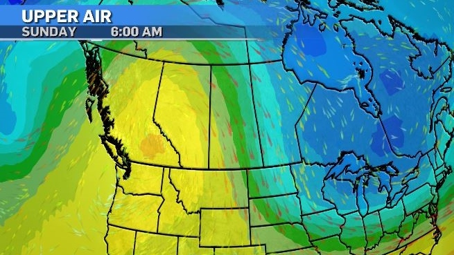
A powerful high pressure system over the Pacific is starting to push in to Western Canada and is bringing mild weather and warm temperatures well above normal for this time of year.

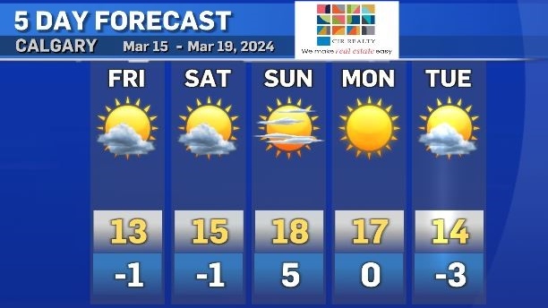
Friday’s forecasted high of 13C will be a mix of sun and cloud through the afternoon with some gusty northwesterly winds at 20-40 km/h.
Typically winds from the northwest at this time of year are an indicator of cooler air moving in, but this ridge of high pressure has pushed our jet stream up north high enough that we will continue to experience warm winds moving in and heating up the province.
This blocking trend will hold steady right through to Tuesday, the first day of spring, and then a dramatic turn in both temperatures and conditions will take place.

By late Tuesday into Wednesday, cold air and a messy looking low pressure system is expected to push back into Alberta.
This system has the potential to produce a spring storm which could include rain, snow, and temperatures diving below seasonal.
We will know more about the intensity of this low by early next week.
Best not to swap out the winter tires quite yet, but for now, enjoy a lovely weekend with highs in the mid-teens perfect for patio chilling.

CTVNews.ca Top Stories

'No one has $70,000 dollars lying around': Toronto condo owners facing massive special assessment
The owners of a North York condominium say they are facing a $70,000 special assessment to fix their building's parking garage. '$70,000 is a lot of money. It makes me very nervous and stressed out of nowhere for this huge debt to come in,' said Ligeng Guo.
Police ID mom, daughter killed in Old Montreal; video shows person break into building before fatal fire
Police released the identities of the mother and daughter who were killed after a fire tore through a 160-year-old building in Old Montreal on Friday.
Tropical Storm Milton forms in Gulf of Mexico, could intensify as a hurricane threatening Florida
Tropical Storm Milton has formed in the Gulf of Mexico. It is located 220 miles (355 kilometres) north-northeast of Veracruz, Mexico.
Trump rallies at same Pennsylvania grounds where gunman tried to assassinate him
Donald Trump picked up where he left off back in July when a gunman tried to assassinate him but only struck his ear before he raised his fist and shouted “Fight!” and was whisked away with blood across his face.
'I screamed in shock and horror': Family faces deadly Vancouver hit-and-run driver during sentencing
The sentencing of the man who pleaded guilty in the deadly hit-and-run in Kitsilano two years ago began on Friday.
Frequent drinking of fizzy beverages and fruit juice are linked to an increased risk of stroke: research
New data raises questions about the drinks people consume and the potential risks associated with them, according to researchers at Galway University in Ireland, in partnership with Hamilton’s McMaster University.
Northwestern Ont. woman charged with arson with disregard for human life
A 30-year-old northwestern Ontario woman has been charged with arson following a structure fire Thursday night, police say.
Inter Miami star Lionel Messi draws a crowd for arrival at Toronto's BMO Field
Argentine star Lionel Messi was on the bench to start Inter Miami CF's game in Toronto on Saturday.
Looking for cheap flights for the holidays? Here are some tips to remember
Travelling on a budget can be stressful, but there are ways you can ensure you're getting the best deal on flights as the holiday season approaches.


