
AS IT HAPPENED
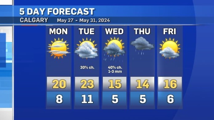
Southern Alberta will start this week with warm and stable conditions, before a pattern breakdown introduces cooler air and instability by the middle of the week when a Pacific trough edges into British Columbia.
In northern Alberta convective activity is possible Monday, especially overnight into Tuesday. More severe thunderstorms are expected along the northern border and into the Northwest Territories before an upper ridge tracks east.
As that upper low establishes itself as the main weather maker for B.C. and Alberta on Tuesday, cooler air coming around the counter-clockwise rotation will impact southern Alberta.
Tuesday night could include some light showers and a quick drop in temperatures as daytime highs settling below seasonal.
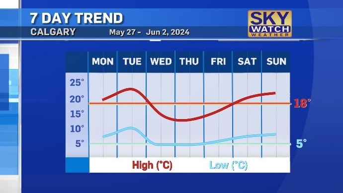
Overnight temperatures will continue to sit consistently outside of the freezing range and warmer weather will return by the weekend.

Prime Minister Justin Trudeau announced on social media that Ottawa has approved Alberta's request for federal assistance after a fast-moving wildfire hit Jasper National Park and its townsite late Wednesday.
Loblaw Cos. Ltd. and its parent company George Weston Ltd. say they have agreed to pay $500-million to settle a class-action lawsuit regarding their involvement in an alleged bread price-fixing scheme.
An IJF and CTV News investigation has found dozens of cases across Canada where multiple money services businesses (MSBs) are incorporated at the same address, sometimes without the knowledge or consent of the location's actual occupant. One money laundering expert calls it an 'abuse of the system.'
A British police officer was suspended from all duties Thursday after a video was posted on social media that appeared to show an officer kicking and stamping on the head of a man lying on the floor of a terminal at Manchester Airport.
Staff at a Barrie child care centre say they are frustrated by what they call a local MPP's inadequate response after a car crashed through a window in one of the toddler rooms.
The North American Aerospace Defence Command (Norad) intercepted two Russian and two Chinese bombers flying near Alaska Wednesday in what appears to be the first time the two countries have been intercepted while operating together.
U.S. President Joe Biden on Wednesday delivered a solemn call to voters to defend the country's democracy as he laid out in an Oval Office address his decision to drop his bid for reelection and throw his support behind Vice President Kamala Harris.
More than 25,000 people have been displaced from Jasper National Park since wildfires started to threaten the picturesque corner of Alberta Rockies on Monday, but the mayor of its namesake municipality says not everyone received an evacuation alert when it was sent out.
A funeral director in St. John's says the bodies piling up in freezers at Newfoundland and Labrador's largest hospital likely belong to people whose loved ones couldn't get enough government help to pay for a funeral.
The Shopping Trends team is independent of the journalists at CTV News. We may earn a commission when you use our links to shop. Read about us.
Prime Minister Justin Trudeau announced on social media that Ottawa has approved Alberta's request for federal assistance after a fast-moving wildfire hit Jasper National Park and its townsite late Wednesday.
One of two raging, wind-whipped fires menacing Jasper, Alta., roared into town Wednesday night and began burning buildings.
More than 25,000 people have been displaced from Jasper National Park since wildfires started to threaten the picturesque corner of Alberta Rockies on Monday, but the mayor of its namesake municipality says not everyone received an evacuation alert when it was sent out.

Lethbridge has been no stranger to extreme heat over the last couple weeks.
To break down barriers, an adaptive water skiing clinic was held for those with mental and physical disabilities on Tuesday evening...
In a heated courtroom exchange, a man accused of conspiring to murder police at the 2022 Coutts, Alta., blockade rejected accusations he and others brought weapons and body armour to the barricade to start a war.

Vancouver city council has voted to allow natural gas for heating and hot water in new construction.
T.J. Walkem, along with more than 80 of his cows, has spent the last few days desperately trying to evade the out-of-control Shetland Creek wildfire.
Environment Canada has recorded a whopping 80,007 lightning flashes in British Columbia from Sunday through Tuesday, and the count continues on Wednesday for what could be a record-breaking stretch.

Police on Vancouver Island are investigating three sexual assaults by strangers that were reported in the past week, though there is no indication the attacks are connected.
A B.C. man who was hired to help a non-profit build a food hub but instead spent the money on personal expenses – including travel, restaurants, booze and cannabis – has been ordered to pay more than $120,000 in damages.
A wildfire burning out of control on Vancouver Island continued to spread Wednesday as the provincial wildfire service assigned more resources to try to contain the blaze.

Prince Albert is grieving the loss of one of its most beloved neighbours and community champions.
As people get out and enjoy the many lakes in our province this summer, those who take care of the waterways are warning about dangerous invasive species that’s a growing threat in Saskatchewan.
A Saskatchewan-born veteran of the Second World War was recently presented with France's highest national order.

A Saskatchewan-born veteran of the Second World War was recently presented with France's highest national order.
Drivers passing through Moose Jaw can expect some delays following a crash near Highway 1.
Residents in Regina and Moose Jaw will soon have better tasting water.

Two women from the Toronto area are speaking out after losing thousands of dollars to a romance scam, including a single mother who lost $62,000.
The day after the doors of the Ontario Science Centre closed to the public on the grounds that its roof was failing and unsafe, the centre’s management made an exception to allow a wedding and reception on its grounds.
One person is dead after a collision in Mississauga Wednesday afternoon.

A possible tornado overturned a truck and uprooted several trees in Brossard, on Montreal's South Shore.
Maude Charron will carry the Canadian flag during Friday's Olympic opening ceremony in Paris. The athlete from Rimouski will also be defending her Olympic gold medal in weightlifting.
Montreal police are investigating after electronic message boards at two road construction sites in Montreal displayed pro-Palestinian political slogans Wednesday morning instead of usual traffic alerts.

Showers along with a risk of thunderstorms will return to the Maritimes on Thursday as a cold front approaches from the west.
Two people are facing drug smuggling-related charges after border officers seized 140 pounds of suspected cannabis at the Halifax Stanfield International Airport on Monday.
U.S. President Joe Biden on Wednesday delivered a solemn call to voters to defend the country's democracy as he laid out in an Oval Office address his decision to drop his bid for reelection and throw his support behind Vice President Kamala Harris.

The Winnipeg Police Service (WPS) is executing a search warrant at a North End property on Wednesday to look for evidence linked to a missing person case from 2021.
An elementary school in Thompson, Man., has gone up in flames on Wednesday.
A saving grace for a dwindling Winnipeg church has come in the form of Winnipeg Jets owner Mark Chipman and Juno-award-winning folk duo The Brothers Landreth.

Western University's Northern Tornadoes Project says a tornado touched down near Perth, Ont. Wednesday night, as a series of severe storms moved across eastern Ontario.
Ottawa police are noting a developing trend in the types of vehicles that are being targeted by thieves in the capital.
Ottawa will receive a break from the rain this weekend, after another storm soaked the capital with heavy rain. The forecast calls for a mainly cloudy day with a 30 per cent chance of showers this afternoon, before sunshine on Friday, Saturday and Sunday.

Staff at a Barrie child care centre say they are frustrated by what they call a local MPP's inadequate response after a car crashed through a window in one of the toddler rooms.
Two people are dead and two others suffered serious injuries following a shooting that police have described as a 'gun battle' outside a plaza in Scarborough, Ont. early Wednesday morning.
At a public District of Nipissing Social Services Administration Board meeting Wednesday afternoon, North Bay's business community made it clear it opposes a homeless hub in or near downtown.
Staff at a Barrie child care centre say they are frustrated by what they call a local MPP's inadequate response after a car crashed through a window in one of the toddler rooms.
Barrie police are using a utility vehicle along the city's waterfront this summer to help officers get to challenging locations and increase their presence throughout the busy area.
The Bank of Canada lowered its key interest rate to 4.5 per cent, as those looking to renew or buy a mortgage watched closely.

A police constable in Guelph, Ont. pleaded guilty Wednesday to discreditable conduct – for a second time.
A Cambridge woman explains why she blames the GRCA for a flood that damaged her home and forced her family to flee in a canoe.
The Waterloo Regional Police Service (WRPS) is searching for a 16-year-old they say escaped a security custody facility in Wilmot Township.

Hundreds gathered Wednesday evening to pay tribute to a young life cut short. Breanna Broadfoot was remembered in a touching candle-light vigil.
The incident happened at Canatara Park in July 23 — offices said the found the suspect fleeing the scene and had to do a high-risk vehicle stop on Wellington Street.
London police have seized multiple firearms, and ammunition following the arrest of a wanted man in the east end of the city in early July.

The residents of Spago Crescent in South Windsor are open to change.
South Essex Fabricating Inc. in Leamington was handed a $65,000 fine following the critical injury of a worker.
Windsor Fire Captain Laz Sofikitis said it’s rare to see a happy ending when they’re told someone is trapped inside a burning building – but there was one Wednesday.


