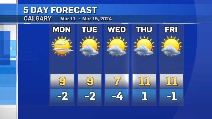
Warm start to the week with double digit daytime highs by the weekend
Daytime highs in Calgary this weekend ranged from 8 C to 10 C – which is five to eight-degrees above seasonal.
This pattern will persist in southern Alberta which is assisting with the melting of snow.
According to Environment and Climate Change Canada, heading in to the weekend there was 16 centimetres of snow on the ground in Calgary (at YYC International).
The “snow on ground” measurement as of Sunday night was five centimetres.
As expected, pooling is occurring around the city, and some surfaces continue to ice up overnight as melted snow re-freezes under sub-zero temperatures.
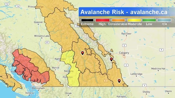
Conditions west of Calgary also improved over the weekend, prompting Avalanche Canada to drop a Special Public Avalanche Warning (SPAW) for K-Country, as well as Kootenay, Yoho, and Banff National Parks.
Weak layers are still present in the snow pack, with most regions rated as a “considerable risk” by the agency, but the threat of human and/or natural-triggered slides has lessened.
The main theme of this weeks’ weather story will be recovery, as snow melts and both daytime highs and overnight lows remain consistently above seasonal.
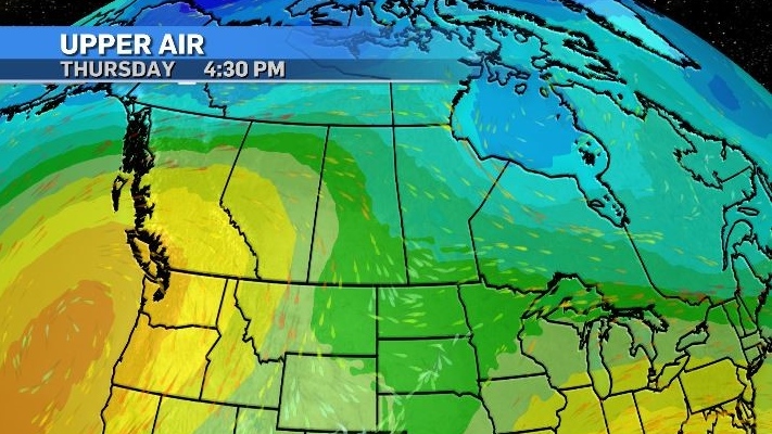
An incoming, strong ridge of high pressure will pull warmer, Pacific air into southern British Columbia and Alberta by the end of the week, and drive daytime highs in Calgary to around 13 C by Sunday, (which is about 10 degrees warmer than average).


CTVNews.ca Top Stories

'Say it to my face': Singh confronts heckling protester on Parliament Hill
NDP Leader Jagmeet Singh confronted a protester for calling him a 'corrupted bastard' on Parliament Hill on Tuesday.
Bride's family speaks as West Vancouver woman sentenced for driving SUV into wedding party
Sixty-five-year-old Hong Xu, who drove her SUV into a crowd of people celebrating a wedding at her next-door neighbour's house in West Vancouver on Aug. 20, 2022, has been sentenced under the Motor Vehicle Act for driving without due care and attention.
Why it's 'very hard' to find work in Canada
Vacancies have steadily fallen since the glut of nearly one million open posts in 2022. At the time, one in three businesses had trouble hiring staff due to a labour shortage. Since then, vacancies have dropped.
Hezbollah hit by a wave of exploding pagers and blames Israel. At least 9 dead, thousands injured
Pagers used by hundreds of members of the militant group Hezbollah exploded near simultaneously in Lebanon and Syria on Tuesday, killing at least nine people.
Sean 'Diddy' Combs jailed by judge after sex trafficking indictment
Sean 'Diddy' Combs headed to jail Tuesday to await trial in a federal sex trafficking case that accuses him of presiding over a sordid empire of sexual crimes protected by blackmail and shocking acts of violence.
Canucks' Dakota Joshua reveals he is recovering from cancer
Vancouver Canucks forward Dakota Joshua revealed Tuesday he underwent cancer treatment over the summer, and will not be ready to play when the team's training camp begins later this week.
Two people charged in murder of Halifax teen; police believe remains have been found
Halifax Regional Police believe Devon Sinclair Marsman, who disappeared in 2022, was the victim of a homicide and two people have now been charged in his death.
What is racketeering? The crime, explained
Sex trafficking, cheating scandals and mob activity may appear very different. But all fall under the broad umbrella of racketeering.
Man from Phoenix, Ariz., missing after truck plunges off Yukon bridge
Whitehorse RCMP say a man from Phoenix, Ariz., is missing after the truck he was travelling in went off a bridge and plunged into the Yukon River.
Shopping Trends
The Shopping Trends team is independent of the journalists at CTV News. We may earn a commission when you use our links to shop. Read about us.


Edmonton
-

'A matter of luck whether or not you make it out alive': Excessive speeders taunt police by posting crimes online
Whether you've been shaken awake by revving engines in the dead of night, or passed on the Anthony Henday like you're standing still, most Edmontonians have some experience with sports cars or motorcycles driving dangerously on city streets.
-
Alberta to boost spending on new K-12 school construction over next three years by $6.5B to $8.6B
Alberta's premier announced a plan Tuesday evening during a televised address her government will boost the amount of money being spent on new school construction over the next three years to $8.6 billion, an increase of $6.5 billion from what was originally promised in the 2024 budget.
-
Man in stolen truck charged in death of partner west of Edmonton: police
Edmonton Police Service found human remains after investigating a case regarding a missing woman.
Lethbridge
-

Lethbridge sees spike in encampments, and in support referrals
The City of Lethbridge's encampment response team continues to see a rise in the number of people experiencing homelessness throughout the summer months.
-
2 Lethbridge youths arrested after fire at southeast business
Two 16-year-old boys have been charged with arson following a fire at a Lethbridge building earlier this month.
-
Lethbridge residents used 16 per cent less water this summer than last
The City of Lethbridge says water usage this summer was lower than expected.
Vancouver
-

Bride's family speaks as West Vancouver woman sentenced for driving SUV into wedding party
Sixty-five-year-old Hong Xu, who drove her SUV into a crowd of people celebrating a wedding at her next-door neighbour's house in West Vancouver on Aug. 20, 2022, has been sentenced under the Motor Vehicle Act for driving without due care and attention.
-
NDP defends Surrey Memorial Hospital efforts after damning letter from doctors
The BC NDP government is on the defensive Tuesday after emergency room doctors at Surrey Memorial Hospital penned a damning call for a leadership change at Fraser Health.
-
Downtown Vancouver BIA launches public safety campaign ahead of B.C. election
The business association for the downtown core is calling on parties running candidates in the upcoming provincial election to lay out their visions for improving public safety in Vancouver.
Vancouver Island
-

'Certainly a wake-up call': B.C. police remind residents to lock their doors after family robbed
Mounties on Vancouver Island are warning people to lock their doors after a Nanaimo-area family was robbed of a high-end vehicle, cash, a computer and other merchandise while they slept.
-
Canucks' Dakota Joshua reveals he is recovering from cancer
Vancouver Canucks forward Dakota Joshua revealed Tuesday he underwent cancer treatment over the summer, and will not be ready to play when the team's training camp begins later this week.
-
B.C. forest watchdog says province should improve watershed management
British Columbia's forests watchdog says a complaint about "excessive" logging has led to a call for the province to improve how it manages watersheds.
Saskatoon
-

Emily Sanche tried to seek medical help for boyfriend before he fatally stabbed her, court hears
Catherine Sanche says her cousin and best friend Emily Sanche never feared her boyfriend Thomas Hamp would hurt her in the weeks leading up to her death in February 2022.
-
Support staff at Saskatoon public schools call for more safety supports after teen set on fire
Support staff at Saskatoon Public Schools are calling for urgent action and more funding to keep members safe in the wake of a brutal attack at Evan Hardy Collegiate earlier this month.
-
Another person charged at Sask. private school at the centre of multiple abuse allegations
Another person affiliated with a Saskatoon Christian school embroiled in legal trouble over multiple allegations of abuse has been charged with assault.
Regina
-

Suspect still at large following assault investigation in Yorkton: RCMP
Three suspects have been arrested, while one remains at large, following an assault in the city of Yorkton.
-
Tornado warning for parts of southwestern Sask. lifted
A tornado warning, which was issued for parts of southwestern Saskatchewan on Tuesday evening, has been lifted.
-
'Didn't meet our expectations': Tempers flare at Riders practice with team winless in 7
It was a heated day at practice for the Saskatchewan Roughriders on Tuesday as head coach Corey Mace had to address the team in a stern matter not once but twice resulting in him telling the group to, “Get off the f***ing field.”
Toronto
-

'Gunshots broke out': Two people dead after shooting in North York
Two men in their 20s are dead after a shooting in North York Tuesday afternoon.
-
One person dead after highrise fire in Scarborough
One person is dead after a fire broke out at a highrise in Scarborough Tuesday evening.
-
Faith leaders urge province to reverse 'deadly decision' to close 10 supervised drug consumption sites
Close to 250 faith leaders from across Ontario are pleading with the provincial government to reconsider its 'deadly decision' to shutter 10 of its 17 supervised drug consumption sites (SCS) by March 2025 and create legislation that would prevent any new locations from opening.
Montreal
-

16 soldiers injured in accident at Valcartier military base in Quebec
More than a dozen soldiers were sent to hospital this afternoon after an accident at a military base in Quebec.
-
Two arrested in Montreal for teen's overdose death linked to synthetic opioids
Montreal police have arrested two alleged synthetic drug traffickers in connection with the overdose death of a 15-year-old in the South-West borough in December 2023. The suspects are 24 and 17 years old.
-
SAAQ closes service centre in Montreal-North after filing complaint with anti-corruption office
Quebec's automobile insurance board said it has closed one of its service centres in Montreal after filing an official complaint with the province's anti-corruption office.
Atlantic
-

Two people charged in murder of Halifax teen; police believe remains have been found
Halifax Regional Police believe Devon Sinclair Marsman, who disappeared in 2022, was the victim of a homicide and two people have now been charged in his death.
-
Feds tell N.S. and N.B. to pay half of Chignecto Isthmus mitigation costs 'before it is too late'
The federal government says it will move on to fund other projects if the New Brunswick and Nova Scotia provincial governments don’t accept a 50/50 split in mitigation costs at the Chignecto Isthmus.
-
Nova Scotia implements new policing standards after Mass Casualty report
The Nova Scotia government says it’s modernizing its policing standards with a more effective and accountable policing model that introduces an auditing system for all policing agencies.
Winnipeg
-

'Looks like a beach here': Manitoba communities soaked by heavy rain
Significant rain Tuesday morning has resulted in road closures and overland flooding in multiple Manitoba communities.
-
'It's disappointing': Kinew responds to ousted MLA's claims of toxic, dysfunctional government
Manitoba Premier Wab Kinew said an MLA ousted from his caucus this week was given a choice before he was shown the door.
-
Prosthetic leg, live goldfish among items left on Winnipeg buses
There's nothing average about some of the stuff that gets lost on the bus
Ottawa
-

Trial underway for Ottawa man accused of murdering wife, injuring daughter
The trial of a man accused of stabbing his wife to death in an attack that also injured his daughter in Ottawa's west end in June 2021 is underway.
-
Baby Tkachuk: Sens captain Brady Tkachuk and wife Emma welcome newborn
Ottawa Senators captain Brady Tkachuk and his wife Emma have announced the birth of their child Ryder Keith Tkachuk.
-
'Say it to my face': Singh confronts heckling protester on Parliament Hill
NDP Leader Jagmeet Singh confronted a protester for calling him a 'corrupted bastard' on Parliament Hill on Tuesday.
Northern Ontario
-

One person dead following North Bay industrial incident
North Bay Police say one person has died following an industrial accident at the Ontario Northland Transportation Commission Rail Yard on Tuesday.
-
GoFundMe cancels fundraiser for Ontario woman charged with spraying neighbour with a water gun
A Simcoe, Ont., woman charged with assault with a weapon after accidentally spraying her neighbour with a water gun says GoFundMe has now pulled the plug on her online fundraiser.
-
'Say it to my face': Singh confronts heckling protester on Parliament Hill
NDP Leader Jagmeet Singh confronted a protester for calling him a 'corrupted bastard' on Parliament Hill on Tuesday.
Barrie
-

New clinic for kids providing hospital alternative
As hospital emergency departments continue to be overwhelmed amidst an ongoing shortage of physicians in Ontario, there's a new Orillia operation hoping to ease the pressure.
-
Animal set on fire in Orillia parking lot, spurring OPP investigation
Provincial police are investigating arson after they say an animal was killed in Orillia.
-
OPP issues warning after motorist escapes suspicious encounter
Police are warning the public after an incident in Minden Hills on Monday morning.
Kitchener
-

The Elvis of Kitchener-Waterloo has passed away
The man, who walked Kitchener, Ont. streets for more than three decades dressed up as the King of Rock and Roll, has died.
-
Shots fired at a home in Woodstock, multiple bullet holes found
Police are looking for the person who fired multiple gunshots into a Woodstock home on Monday afternoon.
-
Effort to get new mobility scooter for Elora, Ont. veteran struck by pickup truck
The community is trying to get a new set of 'wheels' for a Canadian Armed Forces veteran who was recently involved in a collision.
London
-

Safety concerns raised after collision at Lambton County intersection claimed two lives
A Lambton County mayor is calling for action after two people were killed at an intersection in his community on Sept. 11.
-
Two injured in Huron County crash
Huron County OPP attended the scene of a serious two-vehicle collision at the intersection of Babylon Line and Crediton Road in South Huron.
-
'I have constant pain in my ankle': Residents rallying to save St. Thomas' only therapy pool
On July 10, a failure occurred in the therapy pool, leading to extensive flooding into “critical hospital infrastructure.”
Windsor
-

'Absolutely unacceptable': Dilkens on projected 12.9% tax increase
Windsor’s projected tax increase for 2025 is estimated at 12.9 per cent, a number Windsor Mayor Drew Dilkens says must come down.
-
Dodge Durango debate: Will it be cancelled and could its replacement vehicle be built in Windsor?
Auto analysts believe the vehicle will be phased out in favour of a smaller crossover vehicle that could be built in Windsor, much to the ire of the United Autoworkers Union (UAW).
-
With a strong telescope, people can witness a lot of activity in the sky this month
Nasa is warning a "Stadium sized asteroid" will make a close pass Tuesday night.


