Wind warnings issued along the foothills ahead of cooldown tomorrow
 Wind warnings (purple), rainfall warnings (green) and a special weather statement (pink) issued by Environment and Climate Change Canada on Sept. 25, 2024.
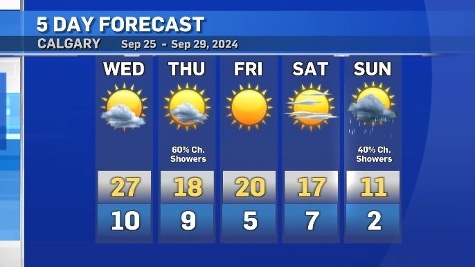
Strong westerly winds will continue to impact southern Alberta on Wednesday with peak gusts in Calgary of 40-60 km/h expected later in the day.
Environment and Climate Change Canada (ECCC) issued wind warnings for Canmore, Kananaskis, Claresholm, Pincher Creek, Waterton and Fort Macleod, as areas closer to the Rockies and in the southwest corner of the province, will experience stronger sustained winds and also gusts.
Peak gusts west of Calgary could reach 90 km/h with peak gusts in the southwest corner of the province as high as 100 km/h.
ECCC issued a rainfall warning on the northwestern side of the mountains because of heavy rain from a prolific atmospheric river that brought over 120 millimetres of rain into some coastal locations in B.C. from Sunday night to Tuesday morning.
As of 7 a.m. Wednesday, a widespread special weather statement remained along the southern border of most of B.C. due to the potential for “late season thunderstorms” to develop.
The greatest threats include heavy rain, pooling, flooding, “a heightened risk of debris flows over areas impacted by burn scars,” and “[v]ery strong wind gusts leading to potential broken tree limbs and power outages.”
All of these advisories are linked to a change in weather patterns as the ridge of high pressure that pushed temperatures 10-12 C above seasonal for the start of the week, gets replaced by a deepening low pressure system.
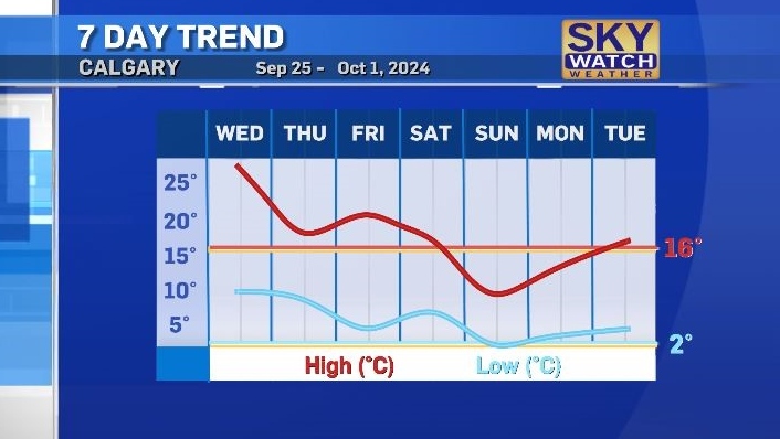
The frontal edge associated with that low will cause winds to intensify overnight and the daytime high on Thursday will be notably cooler than Wednesday, but still warmer than average.
Scattered showers and non-severe thunderstorms are possible in central and northern Alberta on Wednesday.
Rain is also possible Thursday in southern Alberta – with accumulations expected to remain low.
Despite a cooldown, the temperatures for the rest of the week in Calgary will remain above seasonal, with another change forecast for the end of the weekend.
On Sunday and Monday, daytime highs will be below average and lows will be closer to freezing in some communities.


CTVNews.ca Top Stories

DEVELOPING
DEVELOPING MPs to vote today on Poilievre's motion of non-confidence in PM Trudeau
Members of Parliament will vote today on a motion that could — but likely won't — bring down the minority Liberal government, and the Conservatives have already put the House of Commons on notice that more such votes are coming.
'She was victimized by a predator': B.C. court reverses transfer of $1.4M townhouse in elder abuse case
A man who "systematically isolated, manipulated, deceived, abused, and exploited" an elderly North Vancouver woman has lost his ownership stake in her home.
Doug Ford says he wants to build a tunnel under Hwy. 401
Ontario Premier Doug Ford says he wants to build a tunnel under Highway 401 that would stretch from Brampton to Scarborough.
Mortgage changes: Cheaper entry into housing market at steeper costs
Mortgage rule changes allow easier entry into the housing market with lower monthly payments, but also an increased cost of repaying a mortgage.
Coverage denied: Canadians hitting roadblocks with insurers after installing solar panels on their homes
More Canadians are installing solar panels on their homes, but some are facing challenges when it comes to getting home insurance after the panels are put in.
Yogurt recalled in Canada over risk of illness
A major yogurt maker is recalling one of its brands in Canada over concerns that it may cause illness in immunocompromised people.
Population growth slows for first time since start of pandemic as Canadian government clamps down
Population growth in Canada slowed slightly in the last quarter of the year as the government made efforts to reduce temporary migration into the country, Statistics Canada revealed Wednesday.
Israeli army chief says military is preparing for possible ground operation in Lebanon
Israeli army chief says military is preparing for possible ground operation in Lebanon
Helene becomes a hurricane and is expected to intensify as it moves toward Florida
Helene became a hurricane Wednesday after rapidly strengthening in the Caribbean Sea and moved north along Mexico's coast on a path toward the U.S., leading residents to evacuate, schools to close, and officials to declare emergencies in Florida and Georgia.
Shopping Trends
The Shopping Trends team is independent of the journalists at CTV News. We may earn a commission when you use our links to shop. Read about us.


Edmonton
-

New campaign aims to encourage Edmontonians to report more hate crimes
Crime Stoppers and police are launching a campaign encouraging Edmontonians to report hate.
-
Rocks thrown from Red Deer pedestrian bridge: RCMP
Red Deer RCMP have received at least three complaints about rocks being thrown at vehicles from Taylor Pedestrian Bridge.
-
Naheed Nenshi promises increased visibility of NDP in rural Alberta
The NDP’s path to success in a general election that’s still three years away places a new emphasis on small-town Alberta, party leader Naheed Nenshi said.
Lethbridge
-

Lethbridge police hosting Social Disorder and Urban Crime Conference
Dozens of police officers and support workers have come to Lethbridge for the Social Disorder and Urban Crime Conference.
-
Ice cream criminals: Lethbridge break-in sees suspects steal plenty of pints
Police are looking to the public for help after thieves broke into a Lethbridge ice creamery, stealing from the store.
-
'An aspirational goal': U of L lowers fees for Indigenous students
To make higher education an easier step to take for Indigenous students, the University of Lethbridge is dropping some fees for those applicants.
Vancouver
-

Guns, drugs, explosives seized from 'fortified' residence in Surrey, B.C.
Mounties have seized nearly two dozen guns and several kilograms of explosives following a pair of searches at what police described as a "fortified" residence above a business in Surrey, B.C.
-
B.C. NDP pledges to help middle-income homebuyers with 40% of financing
British Columbia's New Democrats have unveiled a plan that Leader David Eby says will help middle-income families purchase a home by financing 40 per cent of the price.
-
BC Conservatives 'laser-focused' on mining as potential multi-billion revenue source
At a campaign stop in the Interior, the leader of the BC Conservatives heavily promoted the mining industry, pledging reforms he believes would unlock billions of dollars in annual government revenue.
Vancouver Island
-

B.C. NDP pledges to help middle-income homebuyers with 40% of financing
British Columbia's New Democrats have unveiled a plan that Leader David Eby says will help middle-income families purchase a home by financing 40 per cent of the price.
-
'She was victimized by a predator': B.C. court reverses transfer of $1.4M townhouse in elder abuse case
A man who "systematically isolated, manipulated, deceived, abused, and exploited" an elderly North Vancouver woman has lost his ownership stake in her home.
-
Guns, drugs, explosives seized from 'fortified' residence in Surrey, B.C.
Mounties have seized nearly two dozen guns and several kilograms of explosives following a pair of searches at what police described as a "fortified" residence above a business in Surrey, B.C.
Saskatoon
-

Enhanced breast cancer screening announced for patients in Saskatchewan
A new program is expanding the capacity of breast cancer screening services across Saskatchewan, and a fundraising campaign is underway to get it done. This all comes as age requirement have been lowered for mammogram screening starting in the new year.
-
EXCLUSIVE
EXCLUSIVE Sask. Party, NDP entering tight race in fall election, new poll says
Based on exclusive new polling data collected by CTV News in partnership with Insightrix Research, the majority of Saskatchewan residents say they’re ready for change, but most don’t see that change happening in 2024.
-
Sask. government says private school now separate from church, but emails show connections remain
The Government of Saskatchewan says a private Christian school, embroiled in abuse allegations, has proved it's met education ministry rules by formally disconnecting from an affiliated church. But, by some indications, connections remain.
Regina
-
 EXCLUSIVE
EXCLUSIVE Sask. Party, NDP entering tight race in fall election, new poll says
Based on exclusive new polling data collected by CTV News in partnership with Insightrix Research, the majority of Saskatchewan residents say they’re ready for change, but most don’t see that change happening in 2024.
-
Two arrested following robbery, police chase near Balcarres, Sask.
RCMP say two women are facing charges that include robbery, flight from police and impaired driving following a robbery in Balcarres, Sask. Monday afternoon.
-
Saskatchewan's police watchdog investigating fatal officer-involved shooting on Fishing Lake First Nation
Saskatchewan’s Serious Incident Response Team (SIRT) has been deployed following a fatal officer-involved shooting on Fishing Lake First Nation.
Toronto
-

Doug Ford says he wants to build a tunnel under Hwy. 401
Ontario Premier Doug Ford says he wants to build a tunnel under Highway 401 that would stretch from Brampton to Scarborough.
-
Hamilton police searching for additional suspects in Grindr ambush robberies
Police in Hamilton are looking for additional suspects allegedly involved in a series of ambush-style robberies where the victims were lured through the adult-only dating app, Grindr.
-
Woman struck, critically injured by vehicle in Mississauga
A woman was rushed to hospital in life-threatening condition after she was struck by a vehicle in Mississauga early Wednesday morning.
Montreal
-

Veteran Montreal police officer says racism a 'cancer eating away' at the SPVM in resignation letter
A veteran Montreal police officer says racism is a 'cancer eating away at the organization' in a stinging resignation letter.
-
Part of the Northvolt energy block could be allocated to others: Quebec minister
Even though Northvolt is experiencing financial difficulty, the Legault government is convinced that the Montérégie battery plant will go ahead, but it is opening the door to the possibility of redistributing part of the promised energy supply block to other companies.
-
Legendary Montreal concert hall La Tulipe shuts down
One of Montreal's biggest cultural institutions, La Tulipe, announced that it has closed down 'for now' in light of a recent court decision.
Atlantic
-

Halifax, Fredericton to host six Canadian university championships
Halifax and Fredericton will host six Canadian university championships over the next four years.
-
New mask requirements at Nova Scotia hospitals start Thursday
Nova Scotia Health is reintroducing masking requirements in ambulatory and inpatient units at provincial hospitals starting Thursday.
-
Both P.E.I. ferries out of service; no crossings for at least two days
Both ferries that take passengers between Nova Scotia and Prince Edward Island are out of service, leaving that mode of transportation off the table for those looking to travel between the two Maritime provinces.
Winnipeg
-

Manitoba to extend gas tax holiday
The Manitoba government is extending the gas tax holiday for a second time.
-
In the gateway to the Arctic, fat, ice and polar bears are crucial. All three are in trouble
Searching for polar bears where the Churchill River dumps into Canada's massive Hudson Bay, biologist Geoff York scans a region that's on a low fat, low ice diet because of climate change. And it's getting lower on polar bears.
-
Winnipeg school sent into lockdown after threatening note found in bathroom
A Winnipeg school went into lockdown Monday after a note threatening students and staff was discovered in the school’s bathroom.
Ottawa
-

Ottawa Senator Claude Giroux's car stolen overnight
NHL star forward Claude Giroux had his car stolen in Ottawa on Tuesday evening, his wife says.
-
Shots fired in Carlington overnight
The Ottawa Police Service is investigating reports of gunfire in Ottawa's west end on Tuesday evening.
-
City of Ottawa says $564k in back taxes uncollectable, recommends write-off
The City of Ottawa has found more than $564,000 in back taxes are no longer able to be recovered and staff are recommending councillors approve writing it off.
Northern Ontario
-
 EXCLUSIVE
EXCLUSIVE Image released of mysterious object shot down over Yukon in 2023
An image of the unidentified object shot down over Canada's Yukon territory in February 2023 has been obtained by CTVNews.ca.
-
Investigation details events leading up to Sudbury woman's death in a collision with OPP boat
A 49-year-old Sudbury woman who was killed in a tragic collision with a police boat June 7 on Nepewassi Lake was told to remain in a residence on an island until police returned to pick her up.
-
Coverage denied: Canadians hitting roadblocks with insurers after installing solar panels on their homes
More Canadians are installing solar panels on their homes, but some are facing challenges when it comes to getting home insurance after the panels are put in.
Barrie
-

New mobile mental health crisis team coming to Barrie with $2.7M boost from the province
The Ontario government is investing $2.7 million in a new mobile mental health crisis team focused on helping those experiencing homelessness or crises.
-
Construction workers trap armed suspect inside vehicle until officers arrive
Three construction workers are being praised for their actions that police in Barrie say likely prevented an armed man from fleeing before being taken into custody.
-
Teen arrested, several suspects on the run following armed home invasion, vehicle theft
A 17-year-old boy faces several charges and police are on the hunt for several more suspects following an armed home invasion and theft in Orillia.
Kitchener
-

Reward of up to $50K offered for information in Joshua Bennett murder
A reward of up to $50K has been issued by Waterloo Regional Police for information leading to the conviction of the person or persons responsible for the fatal stabbing of 18-year-old Joshua Bennett.
-
Woman struck by projectile while walking dog: WRPS
Police received a report of someone being hit by an “unidentified projectile” in the Bristow Creek Drive and Raising Mill Gate area around 6:50 p.m.
-
Couples, contractors claim they were scammed by Ontario wedding vendor
Newlyweds claim the company they hired to take their wedding photos and videos took off with their precious memories – and their money.
London
-
 BREAKING
BREAKING LHSC Shakeup: Board resigns, province appoints David Musyj as supervisor
A statement from the province said Musyj will work closely with LHSC senior leadership and staff to address concerns regarding hospital governance and operations, and management practices, including concerning financial performance, that were found as a result of a third-party review.
-
Barn destroyed in Listowel area blaze
Fire crews from Listowel, Atwood, and Monkton battled the blaze on Line 81, which started around 5 p.m. Tuesday.
-
'Serious injuries' reported after Huron County crash
OPP are investigating a crash that has sent the driver of a truck to hospital with serious injuries. Just before 5 a.m., police reported Donnybrook Line in Lucknow closed between Bruce Road 86 and Zion Road following the crash.
Windsor
-
BREAKING
BREAKING LHSC Shakeup: Board resigns, province appoints David Musyj as supervisor
A statement from the province said Musyj will work closely with LHSC senior leadership and staff to address concerns regarding hospital governance and operations, and management practices, including concerning financial performance, that were found as a result of a third-party review.
-
'POP' unit makes more arrests as part of retail theft blitz
The Windsor police POP Unit has made more arrests as part of a retail theft operation. According to police, 19 people were arrested and 45 charges were laid during the operation last week.
-
Caught on camera: thieves steal sneakers worth thousands from Devonshire Mall
A quartet of alleged thieves pried their way into a Devonshire Mall apparel store early Monday morning, with the store’s owner reporting thousands of dollars worth of shoes were stolen.


