Winter conditions drop daytime highs 12 to 17 degrees below average
Monday brought a harsh return to winter for most of Alberta, prompting a number of weather warnings from Environment and Climate Change Canada (ECCC).
The national weather agency issued extreme cold warnings for northern Alberta with early morning wind chill values near -40.
Central Alberta woke up to snowfall warnings with the national weather agency reporting as much as 20 centimetres of snow, as of 10 a.m. snowfall warnings remained in place for southern Alberta with ECCC forecasting similar snowfall totals for that region.
An infusion of Arctic air along with a lee low pressure system resulted in limited visibility and snow-covered roads throughout much of the province and the B.C. Interior.
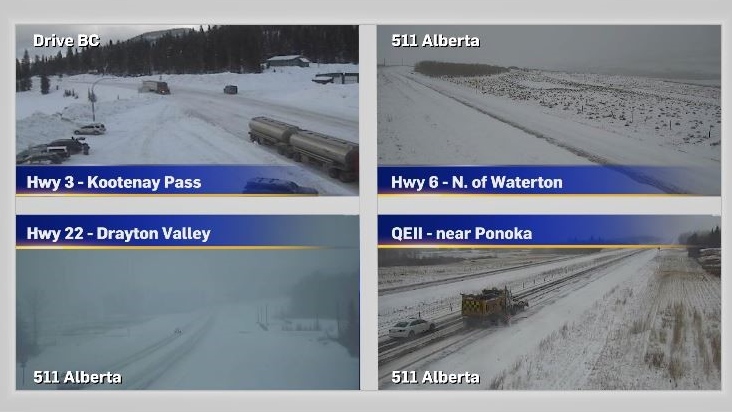
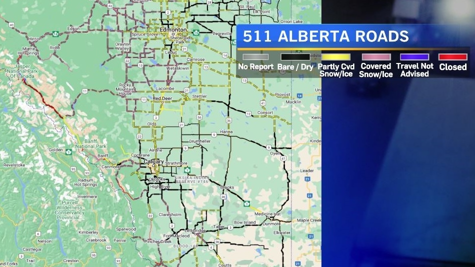
According to the 511 Alberta map and cameras as of 10 a.m. Monday, areas around the capital region and central Alberta were hardest hit.
Strong north winds associated with the frontal system compounded issues from Sunday to Monday producing blowing snow, with widespread negative travel impacts reported across the Prairies.

This week will contain large fluctuations in temperatures.
Sunday’s daytime high of 5 C was 17 degrees warmer than the forecast high on Monday, and Wednesday’s daytime high will be 21 degrees warmer than Tuesday's.
Snow is expected to be intermittent throughout the week with the heaviest snowfall totals for Calgary occurring from Thursday night into Friday.
For the latest weather warnings from ECCC click here. Road conditions from 511 Alberta can be found here, and click here for road conditions from Drive BC.

Calgary Top Stories
-
-
-
 LIVE UPDATES
LIVE UPDATES Multiple homes, businesses 'lost' to wildfire in Jasper National Park: Parks Canada
-
-
-
-
 WEATHER
WEATHER A cooler Thursday, but smoke continues to linger in Calgary
-


CTVNews.ca Top Stories

'There's mom and dad's house': New video appears to show destruction of Jasper neighbourhood
Video posted to social media on Thursday morning appears to show the charred remains of a Jasper, Alta., neighbourhood.
LIVE UPDATES
LIVE UPDATES Multiple homes, businesses 'lost' to wildfire in Jasper National Park: Parks Canada
Officials from Parks Canada and Jasper say "multiple structures, including a number of businesses and homes, in and around the town of Jasper, have been lost" to wildfire in Jasper National Park.
Alberta premier says a third, perhaps half, of all Jasper buildings destroyed by fire
Alberta Premier Danielle Smith says early reports indicate a third and perhaps up to half of all buildings in the historic Rocky Mountain resort town of Jasper have been destroyed in a wildfire.
Prince William's 2023 salary revealed in new report
Newly released financial reports show that William, the Prince of Wales, drew a salary of $42.1 million last fiscal year, his first since inheriting the vast and lucrative Duchy of Cornwall.
Canada to bring home fewest Olympic medals since 2012, according to forecaster
Fewer Canadians are expected to reach the Paris podium than in the previous two Olympic Summer Games, a global data analytics company predicts.
Former judge with disputed Cree heritage likely has Indigenous DNA: law society
The Law Society of British Columbia says a DNA test shows a former judge and Order of Canada recipient accused of falsely claiming to be Cree "most likely" has Indigenous heritage.
Tourist suffers 3rd-degree burns to feet after losing flip flops amid soaring temperatures in Death Valley
A tourist was hospitalized after suffering serious burns on his feet on Saturday when he lost his flip flops at a U.S. national park where temperatures soared past 48 Celsius.
Jennifer Aniston criticizes JD Vance for 'childless cat ladies' remarks: 'I pray that your daughter is fortunate enough to bear children'
Jennifer Aniston is criticizing JD Vance for comments he made in his past about women without children.
'Skibidi Toilet:' If you don't know what it is, you will
'Skibidi Toilet' is already an internet sensation and now its about to get even more exposure after the YouTube series is being developed for TV and film, according to a report by Variety.
Shopping Trends
The Shopping Trends team is independent of the journalists at CTV News. We may earn a commission when you use our links to shop. Read about us.


Edmonton
-
LIVE UPDATES
LIVE UPDATES Multiple homes, businesses 'lost' to wildfire in Jasper National Park: Parks Canada
Officials from Parks Canada and Jasper say "multiple structures, including a number of businesses and homes, in and around the town of Jasper, have been lost" to wildfire in Jasper National Park.
-
Alberta premier says a third, perhaps half, of all Jasper buildings destroyed by fire
Alberta Premier Danielle Smith says early reports indicate a third and perhaps up to half of all buildings in the historic Rocky Mountain resort town of Jasper have been destroyed in a wildfire.
-
'There's mom and dad's house': New video appears to show destruction of Jasper neighbourhood
Video posted to social media on Thursday morning appears to show the charred remains of a Jasper, Alta., neighbourhood.
Lethbridge
-

Lethbridge businesses helping residents beat the heat
Lethbridge has been no stranger to extreme heat over the last couple weeks.
-
Southern Alberta adaptive water skiing clinic growing in popularity
To break down barriers, an adaptive water skiing clinic was held for those with mental and physical disabilities on Tuesday evening...
-
'A revolution': Crown says accused in Coutts murder-conspiracy trial prepared for war
In a heated courtroom exchange, a man accused of conspiring to murder police at the 2022 Coutts, Alta., blockade rejected accusations he and others brought weapons and body armour to the barricade to start a war.
Vancouver
-

Driver will not be charged in crash that killed municipal worker near Victoria
An elderly woman who struck and killed a 52-year-old father who was working in a construction zone near Victoria last year will not face criminal charges in the case, authorities announced Thursday.
-
Victim of fatal Surrey stabbing identified, suspect still at large, IHIT says
Homicide investigators have shared the identity of the man fatally stabbed in Surrey Tuesday night in hopes of furthering their investigation.
-
Shots fired at home in Surrey
No injuries were reported after shots were fired at a home in Surrey Wednesday night, according to authorities.
Vancouver Island
-
Driver will not be charged in crash that killed municipal worker near Victoria
An elderly woman who struck and killed a 52-year-old father who was working in a construction zone near Victoria last year will not face criminal charges in the case, authorities announced Thursday.
-
Fire numbers fall in B.C. as fire near Golden destroys structures, spurs evacuation
Three employees at Canadian Timberframes near Golden, B.C., had no warning when a nearby wildfire jumped the Columbia River and "barrelled through" as many as five nearby homes, the company's co-owner said.
-
Can B.C.'s southern resident orcas be taken off the path to extinction?
The southern resident killer whale known as Tahlequah captured global sympathy in 2018 when she pushed the body of her dead calf for more than two weeks in waters off British Columbia's south coast.
Saskatoon
-

'It was like torture': Saskatoon mother is relieved her son's accused killer is locked up
A Saskatoon mother says she feels a “little bit better” knowing that police caught her son’s accused killer.
-
Sask. police renew calls for information in 44-year-old missing person case
The Prince Albert Police Service (PAPS) is renewing calls for information in the disappearance of Robert Wiggins 44 years ago.
-
'A bright light': Trevor LaPlante identified as Prince Albert homicide victim
Prince Albert is grieving the loss of one of its most beloved neighbours and community champions.
Regina
-

Regina crime rate increases slightly, ranks ninth in country: Stats Can
An annual report from the Canadian Centre for Justice Statistics (CCJS) shows Regina’s crime rate increased slightly from 2022 to 2023.
-
Amazing Race Canada teams to head to Regina in upcoming episode
The upcoming episode of the Amazing Race Canada will have the teams touching down in Regina.
-
Moose Jaw man charged with trafficking guns, lying to officers
Police in Moose Jaw have laid charges following a more than year-long investigation involving firearms trafficking in the city.
Toronto
-

Police identify man and woman killed in quadruple shooting in Toronto
Toronto police have now identified the two victims killed in a quadruple shooting in Scarborough, Ont. early Wednesday morning.
-
Man critically injured in 3-vehicle collision in Etobicoke
A man has been critically injured in a three-vehicle collision in north Etobicoke.
-
New details emerge in wrong-way crash on Hwy. 401 that killed baby and grandparents
Durham Regional Police have confirmed new details about a deadly wrong-way crash on Highway 401 which claimed the lives of a baby and his grandparents following a police chase in April.
Montreal
-

3 tornadoes confirmed as truck toppled, trees uprooted south of Montreal
A tornado overturned a truck and uprooted several trees in Brossard on Montreal's South Shore.
-
Laurentians municipality mulls banning wakesurfing
Public consultations have been launched on a draft bylaw in Saint-Adolphe-d'Howard that would prohibit wake boats from Lac Saint-Joseph and neighbouring Lac Sainte-Marie.
-
Police say 10 arrests made after two Montreal-area homicides last summer
Being placed behind bars did not stop four people with alleged links to organized crime from plotting two killings in the Montreal area last summer using cellphones while in jail to communicate with the outside.
Atlantic
-

Death of husband, wife in Rothesay, N.B., still under investigation: police
Police in Rothesay, N.B., say they continue to investigate the deaths of a man and a woman in the town.
-
N.B. wrestler Leo Burke dies at 76, family says
New Brunswick-born wrestler Leo Burke has died at the age of 76, his family says.
-
Sackville, N.B., man sentenced to seven years in prison in connection with drug trafficking
A 39-year-old man from Sackville, N.B., has been sentenced to seven years in prison following drug trafficking investigations in the southeastern part of the province.
Winnipeg
-

Boys, including nine-year-old, arrested following break and enter, arson: Winnipeg police
Five boys, including a nine-year-old, have been arrested following a break-and-enter and an arson in the West End early Thursday morning.
-
Here are the Manitobans receiving the province's highest honour
Two doctors on the frontline of Manitoba's COVID-19 fight, a long-serving MLA and the chair of the Truth and Reconciliation Commission are all receiving Manitoba's highest honour Thursday afternoon.
-
Driver caught going 202 km/h on Perimeter Highway: Winnipeg police
A driver has been fined and had his licence suspended after allegedly racing another vehicle on the Perimeter Highway on the weekend.
Ottawa
-

Storms cause significant damage in Cornwall, Ont.
A series of powerful storm cells swept across areas of Ontario on Wednesday, hitting parts of Cornwall, Ont. -- particularly hard.
-
Tornado near Perth, Ont. during severe weather on Wednesday, Northern Tornadoes Project says
Western University's Northern Tornadoes Project says a tornado touched down near Perth, Ont. Wednesday night, as a series of severe storms moved across eastern Ontario.
-
Hwy. 417 will be closed this weekend for Preston Street bridge replacement. Here's what you need to know
A stretch of Highway 417 through Ottawa will be closed for 82 hours this weekend for the replacement of the aging Preston Street overpass. CTVNewsOttawa.ca looks at what you need to know about the Queensway closure for the replacement of the Preston Street bridge.
Northern Ontario
-

Worker killed at New Gold mine in northwestern Ont.
An employee operating a piece of equipment in an open pit was killed Wednesday at New Gold's gold mine in Rainy River.
-
'I'm so broke': Two Toronto women speak out after losing $76,000 in romance scam
Two women from the Toronto area are speaking out after losing thousands of dollars to a romance scam, including a single mother who lost $62,000.
-
Greater Sudbury warns of parking ticket text scam
If you recently received a text warning about an overdue parking ticket in Greater Sudbury, it's fake.
Barrie
-
Ont. mayor fires back at 'misinformation' about people defecating on beach
Wasaga Beach's mayor is firing back at unverified claims circulating on social media that people are defecating in the sand at the provincial park.
-
Loose wheel hits 4 vehicles on Highway 400 in Innisfil
Four vehicles sustained damage while travelling along Highway 400 in Innisfil Thursday morning after a wheel came loose.
-
Dump truck driver accused of stunt driving in community safety zone
Provincial police seized a dump truck after the driver was charged with stunt driving through Caledon East late Thursday morning.
Kitchener
-

Home invasion shooting in Cambridge leads to 3 arrests and serious injuries: WRPS
The Waterloo Regional Police Service (WRPS) have arrested three males, including one teen, in connection to a home invasion shooting on Wednesday night that left multiple people injured.
-
Steven Lorentz hoists the Stanley Cup at Kitchener, Ont. cancer centre
Patients at the Grand River Regional Cancer Centre got a special treat, when Steven Lorentz stopped by the Stanley Cup.
-
New charges related to 2023 murder of Guelph man
Four people are facing new charges in connection to a homicide investigation that started nine months ago.
London
-

$1.3-million drug bust by London police
On July 16, police from the guns and gangs section arrested two people after using warrants on two vehicles and a home in Eclipse Walk.
-
Suspect arrested after police said witness to crime was stabbed
On Wednesday, officers were told the suspect wanted in relation to Tuesday's incident may be in the 500 block of Ridout Street near Dufferin Avenue.
-
Bat from Grey-Bruce tests positive for rabies
Grey Bruce Public Health (GBPH) is advising the public to be vigilant about the risk of rabies after a bat tested positive for the viral disease.
Windsor
-

Shed fire causes $300,000 damage
Chatham-Kent firefighters were called to a working structure fire on Thursday.
-
EXCLUSIVE
EXCLUSIVE Newborn data allegedly accessed by doctor seeking profit
The joy and excitement of welcoming a new baby has been marred for a Belle River mom, who says she’s “disturbed” to learn a doctor looking to profit targeted her newborn.
-
City investing $2.24 million in 16 residential road projects
Some residential roads are getting a facelift.


