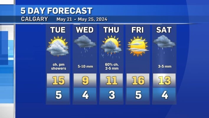
Mid-week dip in temperatures with more rain in the forecast
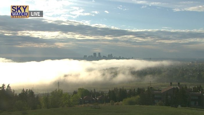
Tuesday started with some dense fog in portions of Calgary.
The mixture of a saturated ground plus normal overnight evaporation and minimal winds meant that the air closest to the surface reached maximum saturation created pockets of thick fog.
Winds are expected to remain fairly mild for most of the day Tuesday so that fog will mix out once the incoming solar radiation starts to warm the surface again.
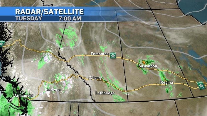
Southern Alberta is the stuck between a cold low complex in Saskatchewan and an incoming cold low from northern B.C., resulting in a day of instability Tuesday before a colder day on Wednesday.
Rain and non-severe thunderstorms are possible in and around Calgary later on Tuesday, with rain expected to be more persistent on Wednesday.
While the temperature will warm up after Wednesday, it will be another five or six days before Calgary sees a seasonal daytime high.
The overnight lows will hover just above seasonal (4 C), however some low-lying communities or areas outside of the city might edge closer to the freezing mark.


CTVNews.ca Top Stories

16-year-old boy fatally shot outside Scarborough plaza identified
Police have identified a teenage boy who was fatally shot in Scarborough’s L’Amoreaux neighbourhood on Saturday afternoon.
Ottawa Food Bank receives largest donation in its 40-year history
210,000 pounds of food was delivered to the Ottawa Food Bank on Saturday, the largest donation in its 40-year history.
Your father’s diet before you were born could have affected your health, a new study suggests
Your father's diet before you were born could have played a role in your health, a new study has found.
Joe Alwyn says breakup with Taylor Swift was 'a hard thing to navigate'
Joe Alwyn is speaking publicly for the first time about the end of his years-long relationship with Taylor Swift.
Prince William shares childhood photo of him and King Charles III for Father's Day
Prince William on Sunday shared a photograph showing him as a child with his father, King Charles III, to mark Father’s Day in the United Kingdom this year.
Ontario Northland bus fire closes part of Highway 400
Part of Highway 400 was closed on Sunday after an Ontario Northland bus caught on fire.
Singh 'more alarmed' after reading report, but won't break from Liberal-NDP agreement
Federal NDP Leader Jagmeet Singh says he is 'even more alarmed than before' after reading the un-redacted report alleging there are MPs and senators who are participating to some degree in foreign interference efforts.
Global study ranks two Canadian cities high on list of most expensive places to buy a home
As Canadians continue to struggle with the extremely high cost of buying a home in some of the country’s major urban centres, a new global report is underscoring just how expensive some of those markets are.
Clooney and Roberts help Biden raise US$30 million-plus at a star-studded Hollywood gala
Some of Hollywood's brightest stars headlined a fundraiser for U.S. President Joe Biden that took in a record US$30 million-plus for a Democratic candidate, according to his campaign, in hopes of energizing would-be supporters for a White House contest they said may rank among the most consequential in U.S. history.
Shopping Trends
The Shopping Trends team is independent of the journalists at CTV News. We may earn a commission when you use our links to shop. Read about us.


Edmonton
-

'Driving like idiots': West-end intersection bane of Highway 16A commuters
An intersection in west Edmonton has some drivers clutching at the wheel as they commute in and out of the city.
-
Tkachuk-McDavid post-whistle scrum is 'classic playoff hockey' in the Stanley Cup Final
Tensions between the Florida Panthers and Edmonton Oilers boiled over midway through Game 4 of the Stanley Cup Final on Saturday night, with a post-whistle scrum featuring two of the most important players in the series.
-
'Feeling confident and having fun': Knoblauch on Game 4 win, going on the road again and Kane's status
Edmonton Oilers head coach Kris Knoblauch talked to reporters Sunday morning after his team's impressive 8-1 win over the Florida Panthers in Game 4 at Rogers Place Saturday night.
Lethbridge
-

City providing free daisies for Lethbridge to celebrate loved ones on Father’s Day
This Sunday is Father’s Day and the City of Lethbridge is helping those honour the memory of loved ones.
-
Jack Ady Cancer Centre unveils Amir and Saker Manji Healing Garden
The Amir and Saker Manji Healing Garden was named after Amir Manji, who went through his own cancer journey, and comes following a $500,000 donation toward the centre from his family.
-
Investigation underway into fatal pedestrian collision in Lethbridge
An investigation is underway into a fatal collision that left one woman dead Thursday night in Lethbridge.
Vancouver
-

Basketball ban at townhouse complex upheld by B.C. tribunal
Members of a B.C. housing co-operative have lost their bid to keep the basketball hoops they installed in their driveways, according to a recent decision from the civil resolution tribunal.
-
Teenager in critical condition after near-drowning at Vancouver Island lake
A teenager was taken to hospital in critical condition after being rescued from Langford Lake on Saturday afternoon, according to authorities.
-
Section of Highway 99 closing overnight Sunday
A section of Highway 99 will be closed overnight, officials announced Sunday.
Vancouver Island
-

Teenager in critical condition after near-drowning at Vancouver Island lake
A teenager was taken to hospital in critical condition after being rescued from Langford Lake on Saturday afternoon, according to authorities.
-
Strike at Cascadia Liquor stores on Vancouver Island over, union says
Striking employees at three Greater Victoria liquor stores will be returning to work after six weeks on the picket line, the union representing the workers announced Sunday.
-
Climate disasters require emergency plans for dialysis patients, experts say
When catastrophic floods severed a bridge and washed away or closed highways in southern British Columbia, Mitchell Dyck and other patients needing regular life-saving dialysis had to be flown to hospital by helicopter.
Saskatoon
-

Saskatoon business leaders to address police board about crime and safety concerns
Two Saskatoon business leaders are appearing before the city’s police board on Thursday to address their growing concerns about crime and community safety.
-
'He killed her': Saskatchewan judge finds Greg Fertuck guilty of killing his wife
Greg Fertuck has been found guilty of First Degree Murder and indignity to human remains in the death of his estranged wife.
-
Two teenage girls, 13 and 17, charged for allegedly using bear spray in Saskatoon robbery
Two teenage girls, 13 and 17, are facing charges in connection with a robbery of a 33rd Street business on Thursday night.
Regina
-

No injuries reported after camper engulfed in flames in parking garage: Regina fire
A fire in an underground parking facility in Regina led to no injuries, according to the city's fire department.
-
Regina celebrates 16th annual JazzFest
JazzFest is back in the Queen City, featuring performances all over Regina by artists from across the globe.
-
Regina Islamic Association celebrates Eid at Mosaic Stadium
Thousands gathered on the field of Mosaic Stadium in Regina, to celebrate the Islamic holiday, Eid al-Adha.
Toronto
-

'Dangerously hot and humid conditions' to begin on Monday, says Environment Canada
SYNOPSIS Canada’s national weather agency is warning of a "prolonged heat event" starting Monday that is expected to bring “dangerously hot and humid conditions” to much of southwestern Ontario.
-
Toronto politicians, advocates and other prominent figures share important lesson imparted by their fathers
For Father's Day, CP24.com and CTVNewsToronto.ca reached out to local politicians, community advocates, and other prominent figures in the city to ask them to share what important lesson they have learned from their dads.
-
Parents located after child found in Toronto's west end on Sunday
The parents of a child that was found in Toronto's west end on Sunday have been located, say police.
Montreal
-

Neighbours petition against Montreal airport's proposed extended hours
Montreal's Trudeau International Airport is considering changing when planes can land and take off by allowing flights until 1 a.m. Public consultations on the idea just wrapped and some of those living near the airport have started a petition opposed to the idea.
-
Rare surgery in Montreal allows 9-year-old girl to live normal life
A rare surgery at the Montreal Children's Hospital is allowing a nine-year-old girl to keep her adrenal glands and live a normal life.
-
Two teens facing murder charges after minor stabbed to death in Chisasibi, Que.
Two minors are facing second-degree murder charges after a teen was stabbed to death in the Cree community of Chisasibi.
Atlantic
-

Shell processing plant suspends operation, 20 staff laid off
Coastal Shell Products in Richibucto, N.B., has suspended all operations.
-
Less than 10 per cent of homeless shelters N.S. promised last year currently in place
Nova Scotia has installed fewer than 10 per cent of the 200 shelters it promised to set up for the province's homeless residents more than eight months after first making the pledge.
-
Market Square patios reopen on interim basis
The city of Saint John is hopeful for the patios to reopen with their full capacity by weeks end.
Winnipeg
-

Western Manitoba pummeled by hail, high winds, power outages following major storm
Parts of the province were ravaged by a series of severe thunderstorms Saturday night, with many still feeling the effects Sunday afternoon.
-
Thousands of participants run with enthusiasm in 2024 Manitoba Marathon
Sunday morning brought no shortage of runners across the city as thousands took part in the 46th installment of the Manitoba Marathon.
-
Winnipeg firefighters battle 4 blazes in 12 hours
Winnipeg Fire Paramedic Service crews were busy this weekend, battling four blazes in just over 12 hours Saturday night and Sunday morning.
Ottawa
-

Environment Canada issues heat warning with temps expected to hit 35 C next week
Environment Canada has issued a heat warning for Ottawa-Gatineau and eastern Ontario in advance of a heat wave that is expected to bring scorching temperatures starting on Monday.
-
Bluesfest adds extra day to accommodate mystery performer
Ottawa Bluesfest has confirmed it has added one more day to its lineup to accommodate a new performer.
-
Collision on Mitch Owens Road leaves pedestrian in life-threatening condition
The Ottawa Paramedic Service says a pedestrian has been taken to hospital in life-threatening condition following a collision in Ottawa’s south-end.
Northern Ontario
-

Police rescue three from Lake Temagami after boat sinks
Ontario Provincial Police members were dispatched to what police officials described as a “sinking vessel” on Lake Temagami.
-
Singh 'more alarmed' after reading report, but won't break from Liberal-NDP agreement
Federal NDP Leader Jagmeet Singh says he is 'even more alarmed than before' after reading the un-redacted report alleging there are MPs and senators who are participating to some degree in foreign interference efforts.
-
Strong majority of LCBO workers vote to back strike if needed, union says
Workers at Ontario's primary liquor retailer are one step closer to a potential strike after union members voted overwhelmingly in favour of a mandate to walk off the job.
Barrie
-

Ontario Northland bus fire closes part of Highway 400
Part of Highway 400 was closed on Sunday after an Ontario Northland bus caught on fire.
-
Motorcyclist taken to hospital in Highway 400 on-ramp crash
A motorcycle rider was taken to hospital following a crash that closed a Highway 400 on-ramp through Barrie on Sunday.
-
Here's how thousands of families celebrated Father's Day in Simcoe County
Whether on the region's links, lakes, restaurants, or parks, thousands of families were out treating their fathers on Sunday through Simcoe County for Father's Day.
Kitchener
-

Pedestrian hit west of Erin
Ontario Provincial Police (OPP) are investigating after a pedestrian was hit in Wellington County.
-
Researchers in Waterloo, Ont. hope to pave the way for lunar development using moon's soil
For some, living on the moon is an idea that is truly out of this world. But for others, it’s a concept edging closer to reality.
-
Most-read stories of the week: stabbing confession, careless driving plea, and big problems for tiny homes
A shocking confession after a stabbing at the University of Waterloo, a driver pleads guilty to careless driving after crash involving CTV Kitchener reporter, and big problems for a woman who wants to install a tiny home in Kitchener.
London
-
 VIDEO
VIDEOVIDEO 'Worrying about an explosion': Black smoke spreads for kilometers after three boats catch fire in Port Stanley, Ont.
Thick, billowing black smoke could be seen for dozens of kilometres after three boats caught fire at a Port Stanley, Ont. marina Saturday afternoon.
-
'It brings our culture together': European soccer championships good for local business
More than 100 people gathered at the Croatian-Canadian National Sports Centre on Westminster Drive in London, Ont. to watch Croatia take on Spain Saturday.
-
On the bright side with Julie Atchison
To brighten your week with good news, CTV London Meteorologist Julie Atchison is showing us the sunny side of things.
Windsor
-

Fatherly advice for a soon-to-be dad on Father's Day weekend
CTV News Windsor reporter Sanjay Maru, who is getting ready to become a father, gathers advice from five men who have already embraced the title of "Dad."
-
City of Windsor names new infrastructure services commissioner
The City of Windsor has named a new commissioner of infrastructure services.
-
Most glassware at Mexican Village stolen by customers: WindsorEats owner
Ahead of the start of the 2024 Carrousel of the Nations festival, WindsorEats — where the Mexican Village is being held — wanted to use creatively-designed glassware to serve drinks. But, according to the owner, 80 per cent of those glasses were taken home by customers during the village's opening night.


