Calgary in fair form this week; flurry risk overnight
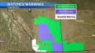
This one screams "chinook." The B.C. interior is coping with a number of snowfall warnings, our upper air pattern is largely westerly.
Expect gusts to stick near yesterday's, though – that's to say, 33 kilometres per hour. Yesterday offers a good example day to break the mold – we got to 9.3 C! You don't always need massive gusts to generate heat. Sometimes, a little thermal advection goes a long way. That said, I’m in a position to not be too disappointed if we crack above the call of 5 C.
The precipitation to the west will press across the foothills and down through southern Alberta early Wednesday – a couple of models have it trying to make a move late Tuesday evening. The high point places this between one and two centimetres locally.
Then, it's done or mostly done before the midweek morning commute.
Either way, Thursday to Saturday is yet another warm spell in the wake of a massive ridge of high pressure. Enjoy it while it lasts – Sunday and beyond, we're into a hefty dip.
YOUR FIVE-DAY CALGARY FORECAST
Tuesday
- Evening: cloudy, chance of showers becoming flurries, low -1 C
Wednesday
- Morning flurry risk, partly cloudy
- Daytime high: 2 C
- Evening: some cloud, low -7 C
Thursday
- Mainly sunny
- Daytime high: 7 C
- Evening: mainly clear, low 2 C
Friday
- Mainly sunny
- Daytime high: 8 C
- Evening: some cloud, low -3 C
Saturday
- Mainly sunny
- Daytime high: 3 C
- Evening: some cloud, low -1 C
Sunday
- Partly cloudy, late flurries
- Daytime high: -2 C
- Evening: flurries, low -7 C
Photo of the day:Tom captured this shot in Kananaskis.
 Clouds atop the Rockies in Kananaskis country. (courtesy viewer Tom)
Submit your weather photos here to see them featured in our article, and perhaps even as the pic of the day during our News at Six! You can also share on Twitter, or to our Instagram at @CTVCalgaryWeather.


CTVNews.ca Top Stories

Former homicide detective explains how police will investigate shooting outside Drake's Bridle Path mansion
Footage from dozens of security cameras in the area of Drake’s Bridle Path mansion could be the key to identifying the suspect responsible for shooting and seriously injuring a security guard outside the rapper’s sprawling home early Tuesday morning, a former Toronto homicide detective says.
Federal government grants B.C.'s request to recriminalize hard drugs in public spaces
The federal government is granting British Columbia's request to recriminalize hard drugs in public spaces, nearly two weeks after the province asked to end its pilot project early over concerns of public drug use.
Stormy Daniels describes meeting Trump during occasionally graphic testimony in hush money trial
Stormy Daniels took the witness stand Tuesday at Donald Trump's hush money trial, describing for jurors a sexual encounter the porn actor says she had with him in 2006 that resulted in her being paid off to keep silent during the presidential race 10 years later.
MPs agree Canadian gov't should improve new disability benefit
The federal government needs to safeguard the incoming Canada Disability Benefit from clawbacks and do more to ensure it actually meets the stated aim of lifting people living with disabilities out of poverty, MPs from all parties agree.
Bye-bye bag fee: Calgary repeals single-use bylaw
A Calgary bylaw requiring businesses to charge a minimum bag fee and only provide single-use items when requested has officially been tossed.
CFL suspends Argos QB Chad Kelly at least nine games following investigation
The CFL suspended Toronto Argonauts quarterback Chad Kelly for at least nine regular-season games Tuesday following its investigation into a lawsuit filed by a former strength-and-conditioning coach against both the player and club.
Boy Scouts of America changing name for first time in 114 years, aiming for inclusivity
The Boy Scouts of America is changing its name for the first time in its 114-year history and will become Scouting America. It's a significant shift as the organization emerges from bankruptcy following a flood of sexual abuse claims and seeks to focus on inclusion.
opinion
opinion Tom Mulcair: Trudeau's handling of Poilievre's 'wacko' House turfing a clear sign of Liberal desperation
When Speaker Greg Fergus tossed out Pierre Poilievre from the House last week, "those of us who have experience as parliamentarians simply couldn't believe our eyes," writes former NDP leader Tom Mulcair in his column for CTVNews.ca
New charges for Ont. woman who previously admitted to defrauding doulas
The Brantford, Ont. woman who was previously sentenced to house arrest after admitting to deceiving doulas has been charged again in connection to a new victim.
Shopping Trends
The Shopping Trends team is independent of the journalists at CTV News. We may earn a commission when you use our links to shop. Read about us.


Edmonton
-

Alberta ombudsman says rules for developmental disabilities program unfair
Alberta's provincial ombudsman says a government body has unfairly denied a young man with autism the supports he needs.
-
Protests as three Indian nationals face B.C. court, accused of Nijjar murder
Three Indian nationals accused of murdering Sikh activist Hardeep Singh Nijjar have appeared by video in a British Columbia court, with scores of Sikh community members inside and outside the hearing.
-
Stanley Cup replica roaming Alberta while Edmonton Oilers fans await the real thing
Like many Oilers fans, Shane Osepchuk has fond memories of the 1980s and 1990s teams that won the Stanley Cup. Unlike most fans, he was a part of those Stanley Cup celebrations.
Lethbridge
-

Woman sought by Lethbridge police in gas station assault and robbery
A woman is being sought by Lethbridge police in connection with a robbery at a gas station that turned into an assault.
-
Lethbridge police seek suspects in 'street robbery'
Lethbridge police are looking for two people they believe were involved in the 'street robbery' of a senior last week.
-
Southern Alberta animal shelters overrun with abandoned pets
Animal shelters across the province are finding themselves frequently at capacity -- or more.
Vancouver
-

Ottawa approves B.C.'s request to recriminalize drug use in public spaces
The federal government approved B.C.'s request Tuesday to recriminalize the use of drugs in public spaces such as hospitals and parks.
-
Orca pod spotted in vicinity of orphan B.C. killer whale, but no evidence of family
A reported sighting of an orca pod off Vancouver Island near where an orphan killer whale is spending her time after escaping from a lagoon has an expert expressing caution and downplaying a possible family reunion.
-
Suspect broke into 2nd floor of New Westminster townhouse, police say
Police in New Westminster say they’re investigating after an alleged break-and-enter at a townhouse over the weekend.
Vancouver Island
-
Ottawa approves B.C.'s request to recriminalize drug use in public spaces
The federal government approved B.C.'s request Tuesday to recriminalize the use of drugs in public spaces such as hospitals and parks.
-
Orca pod spotted in vicinity of orphan B.C. killer whale, but no evidence of family
A reported sighting of an orca pod off Vancouver Island near where an orphan killer whale is spending her time after escaping from a lagoon has an expert expressing caution and downplaying a possible family reunion.
-
Grieving B.C. family seeks apology over paranormal TV show as network removes broadcast
The family of a teenage girl who died in Victoria says it’s traumatized by an episode of a TV show about the paranormal – and its complaints have now led to it being removed from APTN and APTNlumi.ca.
Saskatoon
-

The lone road into this Sask. village is so bad some locals drive through the ditch
Aaron Fosseneuve says the official name of the road into his home community of Cumberland House is Highway 123, but locals joke it’s not as easy as 1-2-3 — “it’s more like a 4-5-6.”
-
Sask. landfill search sets example in quest to find victims of accused Manitoba serial killer
It's been one week since investigators began their search at the Saskatoon landfill, looking for answers in the MacKenzie Trottier case.
-
Sask. touts record number of surgeries after ranking last in knee and hip wait times
Saskatchewan health workers performed more than 95,700 surgeries in the last fiscal year, marking the highest annual surgical volume ever recorded, according to the provincial government.
Regina
-

Sask. touts record number of surgeries after ranking last in knee and hip wait times
Saskatchewan health workers performed more than 95,700 surgeries in the last fiscal year, marking the highest annual surgical volume ever recorded, according to the provincial government.
-
'Life changing injuries,' Regina police give update on officer who was accidentally shot
Regina police say the officer who was accidentally shot by a fellow officer's gun last month suffered 'serious and life changing injuries,' adding he has a 'very' long road to recovery.
-
Sask. launches campaign aimed at sexual exploitation, human trafficking awareness
A new campaign to raise awareness of human trafficking and sexual exploitation was launched in Regina on Tuesday.
Toronto
-

Security guard shot, critically injured outside of Drake's Toronto mansion
A security guard working at Drake’s Bridle Path mansion in Toronto was seriously injured in a shooting outside the residence early Tuesday morning, police said.
-
How Drake and Kendrick Lamar's rap beef escalated within weeks
A long-simmering feud between hip-hop superstars Drake and Kendrick Lamar reached a boiling point in recent days as the pair traded increasingly personal insults on a succession of diss tracks. Here’s a quick overview of what’s behind the ongoing beef.
-
One male dead after being found trapped under steamroller in Whitby
One person has died after they were found trapped under a steamroller Tuesday morning in Whitby.
Montreal
-

Longtime weather specialist Lori Graham announces she's leaving CTV Montreal
CTV News Montreal's ray of sunshine — Lori Graham — is leaving the station after more than 25 years. The longtime weather specialist announced on Tuesday that she is saying goodbye to her CTV family to spend more time giving back to the community, specifically, her faith community on the South Shore.
-
Quebec looking to limit sperm donations per donor after 3 men from same family father hundreds of children
Quebec is looking at tightening the regulations around sperm donation in the province following the release of a documentary that revealed three men from the same family fathered hundreds of children.
-
Montreal police, prosecutors launch project to better address strangulation cases
Montreal police and the Quebec prosecutor's office are launching a pilot project to help authorities better address domestic violence-related strangulations.
Atlantic
-

Alcohol believed to be a factor in boating incident after 2 men die: N.S. RCMP
Two Nova Scotia men are dead after a boat they were travelling in sank in the Annapolis River in Granville Centre, N.S., on Monday.
-
Halifax Regional Police officer charged with assault against female he knows: SiRT
Nova Scotia's police watchdog says a Halifax Regional Police officer has been charged with assault.
-
N.B. government seeks legislation changes on impaired driving, student protection and bail hearings
The New Brunswick government hit the ground running at the legislature with several act amendments on Tuesday.
Winnipeg
-

Encampment in support of Palestinians sets up on the University of Manitoba campus
Students at the University of Manitoba have started a protest encampment on a grassy open area on the campus in south Winnipeg.
-
Abinojii Mikanah: New signage installed on roadway formerly known as Bishop Grandin
New signage has been installed on a Winnipeg roadway that city council unanimously voted to rename because of its ties to residential schools.
-
'A big concern for us': Virologist on danger of avian flu outbreak coming to Canadian cattle
A Canadian virologist says an avian flu outbreak decimating wildlife in the United States should give us pause on this side of the border.
Ottawa
-

Police operation in Carleton Place, Ont. resolved without incident: OPP
Ontario Provincial Police say a police response that prompted shelter-in-place orders is over a barricaded individual in distress. The incident has now been resolved.
-
Travis Green to be head coach of the Ottawa Senators
Travis Green, 53, is the new head coach of the Ottawa Senators.
-
Drivers could face mandatory alcohol screening during traffic stops in Ottawa, police warn
Ottawa police warn drivers pulled over for a traffic stop may be asked to provide a breath sample, as the service continues to see a rise in impaired drivers on the roads.
Northern Ontario
-
Security guard shot, critically injured outside of Drake's Toronto mansion
A security guard working at Drake’s Bridle Path mansion in Toronto was seriously injured in a shooting outside the residence early Tuesday morning, police said.
-
Man taken to Timmins hospital with gunshot wound after shooting on Sixth Avenue
People in Timmins are waking up to a heavy police presence and road closures in the area of Sixth Avenue and Pine Street on Tuesday morning.
-
Sudbury police say suspended driver was speeding, had $26K in drugs in the vehicle
A 28-year-old suspended driver was arrested in Chelmsford last week after a failed attempt at fleeing Sudbury police.
Barrie
-

Bracebridge OPP officer headed to trial on assault charges for incident caught on camera
Bracebridge OPP Const. Scott Anthony has hired Toronto defence lawyer Peter Brauti to defend him ahead of his assault case heading to trial.
-
Police investigate suspicious death in Midland
Police are investigating a suspicious death that took place in the Town of Midland.
-
Man arrested for breaking into Barrie senior's home in east end, police say
A 42-year-old man accused of breaking into a senior's home in the early morning hours on Tuesday faces charges.
Kitchener
-

New charges for Ont. woman who previously admitted to defrauding doulas
The Brantford, Ont. woman who was previously sentenced to house arrest after admitting to deceiving doulas has been charged again in connection to a new victim.
-
$9M in drugs seized by WRPS, two Kitchener residents charged
Two Kitchener residents are facing charges in what police are calling one of the largest drug seizures in the Waterloo Regional Police Services’ (WRPS) history.
-
Shots fired into residential building in Kitchener: WRPS
The Waterloo Regional Police Service (WRPS) is investigating after they say shots were fired into a residential building in Kitchener on Tuesday morning.
London
-
'I’d give them a one-way ticket out of here!' Sarnia councillor reacts in wake of police investigation at homeless encampment
The City of Sarnia will not clear out a homeless encampment in a city park anytime soon. The decision comes after a heated debate and multiple legal opinions — it also came just an hour before a serious stabbing occurred.
-
Security guard shot, critically injured outside of Drake's Toronto mansion
A security guard working at Drake’s Bridle Path mansion in Toronto was seriously injured in a shooting outside the residence early Tuesday morning, police said.
-
Attempted murder charge laid after man stabbed in the neck, Sarnia police say
An attempted murder charge has been laid after a 40-year-old man was stabbed in the neck at Sarnia's Rainbow Park on Monday evening.
Windsor
-

Windsor man on Canada’s top 25 most wanted list arrested
A Windsor man on Canada’s list of most wanted fugitives has been arrested in Edmonton, according to Windsor police.
-
Active investigation after report of dead body near east Windsor mall
Windsor police say there is an active investigation near the Tecumseh Mall in east Windsor.
-
Wanted offender unlawfully at large for 9 years captured by ROPE Squad
The Repeat Offender Parole Enforcement (ROPE) Squad has apprehended a wanted offender who went unlawfully at large nine years ago.


