Calgary to see slightly warmer weather Monday, snow expected Tuesday
Temperatures will improve in Alberta this week, but it will take a while to achieve a full reset to normal ranges.
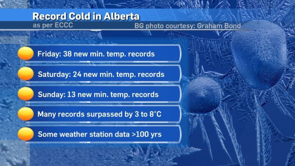
Calgary did not break any weather records over the weekend, but dozens of locations across Alberta did.
The more interesting detail about those records lies within the margin by which many of those records were set. Typically, daily temperature records are exceeded by one to two degrees or less.
However, many of the new records from this weekend were exceeded by three to eight degrees, with a number of those weather stations recording weather data for more than 100 years.
Some locations, including Edmonton, saw air temperatures around -46 C, with wind chill values near -60.
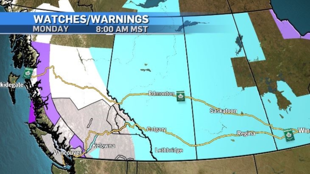
 As of 8 a.m. Monday, the entire province was still under an extreme cold warning as Arctic air remained firmly entrenched over the prairies.
However, that warning should be lifted for portions of the province on Monday.
Environment and Climate Change Canada issues extreme cold warning in Alberta when either the air temperature or the wind chill value reach or exceed at least -40 C for at least two hours. An extreme cold warning can remain in place during a prolonged period of unusually cold temperatures if those temperatures are close to that -40 C threshold and could potentially exceed the threshold again.
 Monday will bring sunshine into southern Alberta with a forecast high of -18 C for Calgary, which is the warmest temperature since last Wednesday, but still 15-degrees colder than the average of -3 C.
Northern Alberta will likely remain under that extreme cold warning Monday with wind chill values in some communities expected to hit -55.
The winter-like weather will continue across Alberta and B.C. even after the cold moves out.
Snow is expected to move in from the Yukon toward the Rockies, which has already prompted some snowfall warnings, and special weather statements in central and southern British Columbia.
If this incoming system can push out the polar air mass, as much as 10 to 15 centimetres of snow is possible in areas like Jasper and Grande Cache. Otherwise, snowfall totals will be slightly lower.
Snow is likely to begin in Calgary mid-morning Tuesday with more steady precipitation expected Wednesday.
Calgary could see as much as 10 to 20 centimetres of snow, with the bulk of that falling on Wednesday. At the low end the City of Calgary could see between 5 to 10 centimetres of snow.


CTVNews.ca Top Stories

The small French town where Newfoundlanders were heroes
It was a battle ripped from the pages of a storybook: Ten soldiers held off hundreds of German troops to save a small French village in the First World War.
'We need new leadership': Liberal MP writes to caucus, says Justin Trudeau should resign
A sitting Liberal MP has written to the federal caucus to say he thinks Prime Minister Justin Trudeau should resign. 'For the future of our party and for the good of our country we need new leadership and a new direction,' said New Brunswick MP Wayne Long in the brief note.
WestJet warns of travel disruption as mechanics union opts to 'continue with strike action'
WestJet says it is 'outraged' after its airline maintenance engineers went ahead with their previously threatened strike on Friday evening.
Minivan slams into a Long Island nail salon, killing 4 and injuring 9, fire official says
A minivan slammed into a Long Island nail salon Friday, killing four people and injuring 9, a Suffolk County fire official said.
Ontario MPP removed from PC caucus over 'serious lapses in judgment'
Premier Doug Ford has removed a member of his caucus due to what he’s describing as 'serious lapses in judgment.' In a statement released Friday morning, the premier’s office said MPP Goldie Ghamari had been removed from the Progressive Conservative caucus 'effective immediately.'
Lt.-Gen. Jennie Carignan to become first woman to lead Canadian Armed Forces
Lt.-Gen. Jennie Carignan will be named Canada's new Chief of the Defence Staff, CTV News has learned, making her the first woman to lead the Canadian Armed Forces.
Multivitamins don't help you live longer, study suggests
Millions of people who take multivitamins everyday may not be reaping the perceived health benefits, according to new research published in the Journal of the American Medical Association.
Is marriage harder than it was 10 years ago? Why one psychologist thinks so
Marriage might be the oldest institution in the world, but it's struggling to adapt to the pressures of modern life. Registered psychologist Adisa Azubuike explains why it's more difficult today.
Martin Mull, hip comic and actor from 'Fernwood Tonight' and 'Roseanne,' dies at 80
Martin Mull, whose droll, esoteric comedy and acting made him a hip sensation in the 1970s and later a beloved guest star on sitcoms including 'Roseanne' and 'Arrested Development,' has died, his daughter said Friday.
Shopping Trends
The Shopping Trends team is independent of the journalists at CTV News. We may earn a commission when you use our links to shop. Read about us.


Edmonton
-

Charges pending after 3-year-old Edmonton boy struck, killed by truck in marked crosswalk
Police say charges are pending after a boy was killed and his mother and sister were injured in a crash in south Edmonton on Thursday.
-
Nenshi, Smith hit Ponoka Stampede in wake of UCP attack ads on new Alberta NDP leader
This year's Ponoka Stampede parade marked the first time Premier Danielle Smith and new Alberta NDP leader Naheed Nenshi attended the same event since Nenshi won his party's leadership contest nearly a week ago.
-
Police report 12 incidents of objects thrown at vehicles from west Whitemud overpasses
Edmonton police on Friday said they're investigating several incidents in which objects were thrown at vehicles on Whitemud Drive on the city's west end.
Lethbridge
-

Tourists expected to hit the road this Canada Day
Plenty of tourists will descend on Lethbridge to see what the city offers. Locals, too, will have no shortage of activities this weekend.
-
'A lot of work': Raymond Stampede ready to kick off in new location
The 122-year-old Raymond Stampede is set to get underway this weekend, but this year’s event will occur at a new location.
-
'Our last stand': Murder-conspiracy trial sees phone texts from Coutts blockade
A picture of rage and determination among COVID-19 protesters at the border blockade at Coutts, Alta., was spelled out in text messages shown Thursday at a murder-conspiracy trial.
Vancouver
-

B.C. Liberal MPs call for Trudeau's leadership to be assessed as ex-premier calls for his resignation
The chorus of calls for Prime Minister Justin Trudeau to step down as Liberal leader includes former B.C. premier Christy Clark.
-
Abbotsford student's speech about accessibility challenges at her school censored by administrators
As part of her Grade 12 art activism class, Lexis De Meyer was tasked with investigating accessibility challenges faced by people with disabilities in her community of Abbotsford.
-
Surrey Police Service offering $10K signing bonus to bolster staff
Just months away from taking over as the police of jurisdiction, the Surrey Police Service is putting up some cash in hopes of recruiting more officers.
Vancouver Island
-

Pedestrian struck and killed in Courtenay, B.C.
A 44-year-old man is dead after he was struck by a vehicle early Friday morning in Courtenay, B.C.
-
Dad's bid to prevent children's HPV vaccinations rejected by B.C. court
A vaccine-fearing father has been ordered not to discuss the HPV vaccine – or even the human papillomavirus itself – with his children after losing a battle against their mother in B.C. Supreme Court.
-
Navy facility in Canadian Arctic 'could be finished this season,' a decade overdue
Nearly a decade behind schedule, the Canadian military’s long-promised naval refuelling station in the High Arctic could open as early as this summer, albeit with restrictions on the facility's operations and serious questions about its long-term viability.
Saskatoon
-

Saskatoon city council votes in favour of housing accelerator fund after two days of contentious debate
Following a 12-hour marathon meeting on Thursday which saw nearly 50 speakers both in favour and against the fund, councillors were back at City Hall Friday to ask administration what they were being faced with and vote on the changes.
-
Family of nine unharmed after Saskatoon house explosion
The Saskatoon Fire Department is investigating the cause of a house explosion Thursday night.
-
Historic Saskatoon bakery hands ownership to its Ukrainian employees
A Saskatoon staple, Nestor's bakery, which was founded nearly a century ago and has served Ukrainian baked goods on 20th street, will be changing ownership.
Regina
-

Domestic violence resource card initiative develops in southern Saskatchewan
A new domestic violence resource card initiative is taking the lead in Yorkton and is quickly expanding in southern Saskatchewan.
-
'It's problematic': Frustration growing as Regina city council meetings drag on, tabled items pile on
Frustration is growing amongst the public and members of Regina city council as marathon meetings drag on.
-
Missing Moose Jaw man found dead, no foul play suspected: Police
An 80-year-old Moose Jaw man who was reported missing earlier this week has been found dead.
Toronto
-

Raves, weddings, and field trips: GTA residents share memories of shuttered Ontario Science Centre
A rave at the Ontario Science Centre was the place where Greg LeBlanc says his relationship first began with his husband Mark in 1997.
-
‘It just makes me feel home’: LGBTQ+ newcomers celebrate first Pride in Canada
When Zhya Aramiy was living in Turkey and Iraq, he had to keep his Pride flags hidden away.
-
Group which operates Revue Cinema obtains court injunction to stay open
The non-profit group which runs Toronto's oldest operating movie theatre says it will remain open after receiving a court injunction halting an eviction next week.
Montreal
-

Provocative or crude: Do some corporate accounts go too far on social media?
In the age of quick attention spans and fleeting infatuations, many large companies are working hard to stay relevant and, most importantly, on-trend.
-
Quebec says deficit is $1.2B higher than expected
The Quebec government announced Friday that its deficit for the 2023-2024 fiscal year is higher than expected, reaching $7.5 billion due to stagnant economic activity in the province.
-
3 dead, multiple injured after fiery crash on Laval roadway
Three people are dead after a fiery crash involving a large truck and three other vehicles north of Montreal Friday afternoon.
Atlantic
-

Steel officially cut for new Navy ships in Halifax
The Irving Shipbuilding shipyard has started cutting steel for the next fleet of the Royal Canadian Navy’s next generation of warships.
-
'As I turned around, he lunged and grabbed me': Fredericton woman recovering after attack in parking lot
The Fredericton Police Force has laid three charges against a Fredericton man in connection with an alleged assault in a public parking lot on Wednesday.
-
‘I’m terrified to go downtown again Halifax’: woman recovering after altercation with group of men who allegedly made homophobic slurs
A birthday celebration turned into a nightmare for a same-sex couple in downtown Halifax on Saturday after they got into a violent altercation with a group of men.
Winnipeg
-

'It's something to see': How water towers have transformed into Manitoba skyline icons
Water towers in Manitoba have seen a transformation over the years. While some of these pieces of infrastructure, which were designed to bring water to residents, have faded and disappeared over time, others have begun a new life – places that showcase history, where memories are made and a sense of pride is born.
-
Plan to improve section of Route 90 clears hurdle at Winnipeg City Council
A $586-million plan to widen and improve a section of Route 90 has cleared a hurdle at city hall, though it still remains unclear how the upgrades will be paid for.
-
'His heart still beats on': Young track star remembered for giving the gift of life
Not a day goes by when Scott and Amanda Cadman don’t think about their son Kirk.
Ottawa
-

Rain, thunderstorms in the forecast for Ottawa this Saturday
Showers and a risk of thunderstorm are in the forecast this Saturday in Ottawa.
-
NEW
NEW Sources: Dr. Brian Nadler expected to be acquitted of first-degree murder charges next week
The eastern Ontario doctor is facing four first-degree murder charges related to elderly patients who died under his care at the Hawkesbury hospital in 2021.
-
Braeside's Dean Letourneau picked 25th overall by Boston Bruins in NHL draft
It's a big moment for Ottawa Valley hockey player Dean Letourneau, who is expected to attend Boston College next year.
Northern Ontario
-

Five survivors from Sudbury, Ont., rescued in human trafficking investigation
Six people have been charged in a provincial human trafficking investigation that identified five survivors from Greater Sudbury.
-
Sudbury senior to be homeless after apartment eviction
A Greater Sudbury senior says she will be homeless after being evicted from her apartment.
-
Fallen tree damages fence, allowing 50 bison to escape in northern Ont.
Anyone travelling along Highway 64 near Lavigne, Ont., should be on the lookout for bison crossing the road.
Barrie
-

Investigation closes access to highway from Bayfield Street in Barrie
Access to the highway from one of Barrie's busiest roads has been temporarily closed by police.
-
'It just doesn't add up': Barrie bistro owner faces $38,000 landlord debt dispute
A Notice to Terminate posted on the front door of a downtown Barrie establishment shortly after its closure states the owner owes thousands in rent and utilities, but the owner argues he paid for more than his fair share before closing up shop.
-
Victim of head-on crash caused by impaired driver gives emotional statement
The woman who nearly died in a crash involving an impaired driver on Highway 26 in Springwater in 2022 gave an emotional victim impact statement on Friday.
Kitchener
-

Occupy UW calls university's court order a 'scare tactic' to silence students
Members of a pro-Palestinian encampment at the University of Waterloo have broken their silence surrounding a lawsuit and injunction filed by the school.
-
Eight people displaced by Kitchener house fire
Officials say no one was hurt after flames destroyed the front porch of a Kitchener home on Friday.
-
Motorcyclist seriously injured in Cambridge crash
A Kitchener woman was taken to hospital after her Kawasaki motorcycle was involved in a collision with a Dodge pickup truck in Cambridge.
London
-

What's open and closed on Canada Day in London
Lots happening in your own backyard this holiday weekend, but it’s important to plan ahead as many people are taking the time off, and many local shops, restaurants and attractions may have adjusted hours.
-
-
WestJet warns of travel disruption as mechanics union opts to 'continue with strike action'
WestJet says it is 'outraged' after its airline maintenance engineers went ahead with their previously threatened strike on Friday evening.
Windsor
-

'Sticky, moist air' for your Saturday
Hot, humid, and wet are three words to describe the weather in Windsor-Essex Saturday.
-
'We need new leadership': Liberal MP writes to caucus, says Justin Trudeau should resign
A sitting Liberal MP has written to the federal caucus to say he thinks Prime Minister Justin Trudeau should resign. 'For the future of our party and for the good of our country we need new leadership and a new direction,' said New Brunswick MP Wayne Long in the brief note.
-
WestJet warns of travel disruption as mechanics union opts to 'continue with strike action'
WestJet says it is 'outraged' after its airline maintenance engineers went ahead with their previously threatened strike on Friday evening.


