Extreme cold snap continues, temperatures moderate slightly
CALGARY -
Temperatures on the rise Monday night with morning temperatures reaching the minus mid-20s, and feeling like the -30s with the wind. Cloud cover returns Tuesday morning with light snow along the foothills spreading southeast to the U.S. border before tapering off Tuesday evening. Daytime highs are slightly warmer Tuesday across central and southern Alberta but still remain within extreme cold warning criteria. Warmer weather in sight for New Year’s Day.
Here’s the five day:
Tuesday:
· Becoming mostly cloudy with a chance of afternoon flurries
· Daytime high: -16 C, wind chill -26
· Overnight: Chance of evening flurries, -27 C, wind chill -36
Wednesday:
· Mostly sunny
· Daytime high: -20 C
· Overnight: Becoming mostly cloudy, -23 C
Thursday:
· Mostly cloudy, chance of flurries
· Daytime high: -15 C
· Overnight: Clearing, -24 C
Friday:
· Mostly sunny
· Daytime high: -14 C
· Overnight: Clearing, -22 C
Saturday:
· Becoming cloudy later in the day
· Daytime high: -7 C
· Overnight: Partly cloudy, -5 C


CTVNews.ca Top Stories

MPs to vote on motion to oust House Speaker Greg Fergus over allegations of partisanship
Members of Parliament will be voting Tuesday on a Conservative-led motion to oust House of Commons Speaker Greg Fergus, amid renewed concern over his 'alleged lack of impartiality.'
Why young people keep getting caught in debt traps and how to break the cycle
Canadians are feeling the squeeze between incomes that haven't kept up with the cost of living, housing crises in markets across the country and rising interest rates brought in to control inflation. Experts share some tips for managing debt and spending.
Richard Dreyfuss' comments about women, LGBTQ2S+ people and diversity lead venue to apologize
The actor Richard Dreyfuss showed up in a dress at a 'Jaws'-themed event in Massachusetts, where the blockbuster 1975 movie he starred in was shot, and then proceeded to make demeaning remarks about women, LGBTQ2S+ people and diversity.
Severe thunderstorms, 15 cm of snow: Canadian weather forecast highlights
Well into spring, some parts of Canada could experience a wintry comeback, while other areas are bracing for severe thunderstorms, according to local forecasts.
WATCH
WATCH Airline pilot treated to stunning northern lights show during U.S.-Portugal flight
An airline pilot got quite a show on May 11 while flying from San Francisco to Lisbon when a solar storm caused stunning auroras.
Here's how new AI tech could change the iPhone
Generative AI, artificial intelligence that can provide thoughtful and thorough responses to questions and prompts, could potentially breathe new life into Apple’s iPhone lineup at a time when competitors are threatening to leave the company behind in the race to shape what could be a world-changing technology.
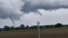
Tornado touches down west of the Island of Montreal
Emergency services in the town of Rigaud, Que. are investigating after a tornado touched down shortly after 5:30 p.m.
At least 60 reports of Lyme disease so far as Ontario enters tick season
Peak tick season is only just beginning but reports of bites – and tick-borne illnesses – are already higher than normal in Ontario.
Spy watchdog's foreign interference review finds 'unacceptable gaps' in accountability
The Canadian Security Intelligence Service and Public Safety Canada lacked a system for tracking who received and read specific intelligence on foreign interference, creating 'unacceptable gaps in accountability,' the national spy watchdog has found.
Shopping Trends
The Shopping Trends team is independent of the journalists at CTV News. We may earn a commission when you use our links to shop. Read about us.


Edmonton
-
Alta. woman, Sask. man killed in crash likely involving drugs or alcohol: RCMP
An SUV driver ran a stop sign before a double fatal collision northeast of Edmonton early Tuesday morning, RCMP believe.
-
Homicide unit investigating man's death in Calder
Police are investigating the suspicious death of a man early Monday morning.
-
1 in hospital after downtown stabbing: police
A woman was taken into police custody after a stabbing in central Edmonton Monday night.
Lethbridge
-

Lethbridge gardeners optimistic amid rain, but summer could still see dry conditions
Lethbridge gardeners are hoping the growing season will be better than previously expected, thanks to recent rain.
-
No charges for officers who surveilled Alberta legislature member: watchdog letter
Alberta's police watchdog says there will be no criminal charges for two police officers who broke rules when they surveilled a legislature member.
-
Organizers have high hopes as Lethbridge launches collector and entertainment expo
The entertainment and collector expo in Lethbridge got underway Friday afternoon.
Vancouver
-

Decision on cellphone use in Vancouver schools pushed back to future school board meeting
A discussion on cellphone use for Vancouver students in kindergarten to Grade 6 will be put off to a future school board meeting, trustees decided Monday.
-
Nature Conservancy of Canada buys B.C. grasslands for new conservation area
The Nature Conservancy of Canada says a new conservation area north of Cranbrook, B.C., will protect important bird habitat and preserve grasslands in the province's southeast.
-
Passenger killed, 2 drivers taken to hospital after Surrey car crash
One person died and two others were taken to hospital Monday after a crash in Surrey's Cloverdale neighbourhood.
Vancouver Island
-

B.C. universities focus on talks with encamped protesters as others take legal action
Some Canadian universities are taking legal action to end pro-Palestinian encampments on their campuses, but three schools in British Columbia are taking less confrontational approaches.
-
'A tight situation right now': B.C. gets D+ on Food Banks Canada's poverty report card
Peng-Sealin Penny is a senior on a pension and finds herself once a month coming to the Mustard Seed Food Bank in downtown Victoria for groceries. She's one of the many who rely on the non-profit to make ends meet.
-
B.C. senior prepares to move due to devastating effects of fraud
A Courtenay, B.C., senior is downsizing and packing to move as she comes to accept she can no longer afford to stay in her home, after falling victim to a scam that robbed her of her life savings worth more than $100,000.
Saskatoon
-

'The information that he had': Moe says he believes former house leader didn't remember bringing gun into legislative building
Former Government House Leader Jeremy Harrison has apologized for what he calls a 'terrible mistake' after it became known that he brought a firearm into the legislature approximately a decade ago.
-
'We feel neglected': Cumberland House calls on government officials to see the road for themselves
Residents of a remote village in Northern Saskatchewan are calling on government officials to visit their community and see their road conditions first hand.
-
Saskatoon police renew calls for historic homicide of Linda Clark
The Saskatoon Police Service (SPS) is renewing calls for information about the historic homicide of Linda Clark 10 years ago.
Regina
-
'The information that he had': Moe says he believes former house leader didn't remember bringing gun into legislative building
Former Government House Leader Jeremy Harrison has apologized for what he calls a 'terrible mistake' after it became known that he brought a firearm into the legislature approximately a decade ago.
-
Why one doctor is calling for more Indigenous supports in Sask. hospitals
The Saskatchewan Health Authority (SHA) has First Nations and Metis Health Services available directly in Saskatchewan's major cities, but Saskatchewan doctors hope to see access expanded.
-
Controversial residential high-rise development before city planning commission
A proposed residential high-rise apartment in the Douglas Park neighbourhood is in front of the City of Regina Planning Commission.
Toronto
-

At least 60 reports of Lyme disease so far as Ontario enters tick season
Peak tick season is only just beginning but reports of bites – and tick-borne illnesses – are already higher than normal in Ontario.
-
Feds, Ontario reach $357M agreement for affordable housing
The federal and Ontario governments have reached an agreement on a national housing strategy that will unlock $357-million for affordable housing after months of negotiations.
-
Five of Ontario's top 10 worst roads are located in the Toronto area
A new pothole-riddled street in Hamilton has taken the top spot for the worst road in Ontario, according to a new list released by the Canadian Automotive Association (CAA) on Tuesday.
Montreal
-
Tornado touches down west of the Island of Montreal
Emergency services in the town of Rigaud, Que. are investigating after a tornado touched down shortly after 5:30 p.m.
-
Cutout of Netanyahu hanged from McGill University's Roddick Gates
A hanging image of Israeli Prime Minister Benjamin Netanyahu was allegedly on display for 'several hours' outside McGill University.
-
Tour de l'Ile, Tour la nuit prepare to take over Montreal
Montreal's annual Tour de l’Ile and Tour la Nuit cycling events are set to take over the downtown area this weekend.
Atlantic
-

Rain and thunderstorms moving east; wind to ease Tuesday night in the Maritimes
Rounds of rain and showers will continue to move eastward across the Maritimes heading into Tuesday evening.
-
Crash between motorcycle, pickup truck sends 33-year-old N.S. man to hospital with life-threatening injuries
A Nova Scotia man is in hospital following a crash between a motorcycle and pickup truck in Lakeville, N.S., on Sunday.
-
Sextortion scams targeting young males on the rise: N.S. RCMP
The RCMP in Nova Scotia is warning the public of an increase in sextortion scams targeting young males in the province.
Winnipeg
-

Manitoba premier says he wants stability, increases in federal transfer payments
Manitoba Premier Wab Kinew says he wants predictability, with room for increases, in federal transfer payments.
-
Manitoba parent sued over 'defamatory' Facebook comments
A Manitoba school division is saying comments made by a parent that were posted on social media are defamatory and untrue in a recently filed lawsuit.
-
'An increase that we've noticed': Collisions between vehicles and pedestrians on the rise in Winnipeg
Three pedestrians have been hit by vehicles in Winnipeg in as many weeks, and according to the Winnipeg Police Service, these types of incidents are on the rise.
Ottawa
-

Ottawa firefighters, police bring down protesters from Hwy. 417 signs, causing delays
A group of protesters forced the closure of a Highway 417 ramp in Ottawa on Tuesday morning.
-
Man dies after being rescued from Ottawa River
Emergency crews responded to a call just after 10 a.m. for a person “appearing to be in distress” at the Deschenes Rapids.
-
LISTEN
LISTEN Is eastern Ontario a new tornado alley?
Environment Canada senior climatologist David Phillips says Ottawa has seen an increase in frequency when it comes to tornadoes and violent wind events over the last six years.
Northern Ontario
-
Northern Ont. police say suspicious death is murder, identify victim as missing man
Police in northern Ontario identified the body found shot to death in the woods last week as a missing man saying it was murder.
-
Coroner's inquest begins in death of Indigenous man shot by northern Ont. police
Three northern Ont. police officers who shot and killed an Indigenous man four years ago were cleared of wrongdoing and now a coroner's inquest is underway to prevent similar incidents in the future.
-
Gay Lea Foods, potential buyer of Thornloe Cheese in 'productive discussions'
There could be good news on the horizon for northern Ontario dairy farmers and the community of Temiskaming Shores.
Barrie
-

Stolen pickup truck involved in crash on Highway 400
An allegedly stolen pickup truck crashed into two tractor-trailers on Highway 400.
-
Police arrest suspect involved in the IED explosion in Barrie, Ont. parking lot
A 36-year-old man has been arrested for a car bombing incident that took place in Barrie last fall.
-
Judge expects resolution in murder case involving former Ont. fire captain
The former Brampton fire captain accused of murder in his wife's death appears headed for anticipated resolution in the case.
Kitchener
-

ER closed at Listowel Memorial Hospital due to fire
No injuries have been reported after a fire at Listowel Memorial Hospital Tuesday morning.
-
At least 60 reports of Lyme disease so far as Ontario enters tick season
Peak tick season is only just beginning but reports of bites – and tick-borne illnesses – are already higher than normal in Ontario.
-
Dog found starved, covered in human waste, at Guelph Lake
A Chihuahua is recovering after she was found abandoned in the holding tank of a public washroom at Guelph Lake.
London
-
Charge laid after fatal Oxford County crash
OPP have charged one person as a result of a fatal crash in Oxford County earlier this month. A 21-year-old from Beachville is charged with dangerous operation causing death after the crash on May 2.
-
Loaded firearm seized during traffic stop in Strathroy
A traffic stop in Strathroy has led to the seizure of a weapon and ammunition. Around 3 p.m. on Monday, officers stopped a vehicle in the west end of Strathroy for a Highway Traffic Act offence.
-
State of Emergency declared in West Grey
A state of emergency has been declared for the Municipality of West Grey because of the, "imminent removal of the in-patient beds from the Durham Hospital."
Windsor
-
Arrest made in stabbing of teen boy
A 19 year old has been charged with aggravated assault and assault with a weapon after a 16-year-old boy was stabbed multiple times following a verbal dispute on Saturday night.
-
Marianas Trench coming to Caesars Windsor this fall
Marianas Trench is bringing The Force of Nature Tour to Caesars Windsor with special guest LØLØ for an all-ages performance this fall.
-
Two youths arrested for assault with a pellet gun
Chatham-Kent police say two teen boys have been charged with assaulting another youth.


