Heat warnings issued for most of Alberta with daytime highs 9 to 12 C above average
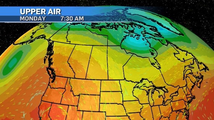
As expected a strong ridge of high pressure has moved into the western Prairies and is pushing daytime highs into the mid-to-high 30s.
This ridge will be slow-moving with anchoring lows at the base of either side of it – inhibiting eastward progression.
Underneath this ridge conditions will be stable – meaning unlike typical summer days where warm daytime temperatures can lead to afternoon and evening thunderstorms, this setup will be one with little chance of convective activity.
Normally, warmer air will rise from the surface until it reaches a state of equilibrium – or until it settles at a level where it is no longer warmer than the air surrounding it.
This is usually the level we see clouds develop due to water vapour condensing out of the (formerly rising) air parcel. Under a synoptic setup like the one we are experiencing – not only is cloud development unlikely due to warm temperatures extending higher in the atmosphere, but if clouds do develop they are unlikely to encounter any forcings that would lead to storm development.
The danger with a period of persistently warm temperatures is the toll placed on the human body as the body attempts to cool off. This is especially true once ambient temperatures exceed normal body temperatures – a situation that is likely in portions of Alberta by the middle of the week.
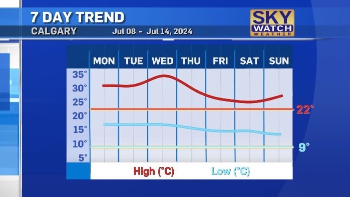
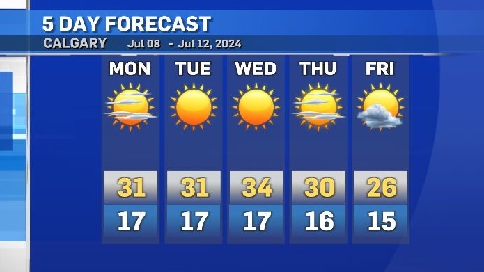
Normally, overnight temperatures in our region cool off enough that it is easier to find opportunities to cool down. This week overnight temperatures are expected to remain above at least 14 C.
In their heat warning bulletin Monday, Environment and Climate Change Canada urged people to “pay particular attention to individuals that can experience earlier or more severe effects from heat including infants, children, seniors, and individuals with pre-existing lung, heart, kidney, nervous system, mental health or diabetic conditions, outdoor workers, as well as those who are socially isolated.”
With temperatures expected to remain between nine to 12 C above average until at least Thursday it will be imperative to stay hydrated and try to take breaks from the heat – regardless of age or health conditions.
Animals are also vulnerable to the ill-effects from heat – so timing activity and providing access to fresh water is advised.
That ridge is expected to start to track east by the end of the week, allowing daytime highs to cool below the heat warning threshold of maximum temperatures (highs) of at least 29 C with minimum temperatures (lows) of at least 14 C for at least two consecutive days.
That being said – even with a cooldown, both daytime highs and overnight lows are still expected to remain above seasonal.


CTVNews.ca Top Stories

'Environmental racism': First Nations leaders claim cancer-causing contamination was covered up
The people of Fort Chipewyan believe the federal government believe the federal government knew its water was contaminated and hid the issue for years. Now the chief of the Athabasca Chipewyan First Nation is leading the call for immediate action.
Taste of home: Tiffin lunch boxes bring comfort, affordability to immigrants
Yugali Bharote starts her day in the kitchen, preparing lunch boxes for her sons bound for school – but she doesn’t stop there. She then prepares almost a dozen lunch boxes for customers who have subscribed to her homemade meals.
Liberal, Conservative MPs to speak at Oct. 7 march to Parliament Hill
A Liberal MP and a Conservative MP will be part of a team delivering speeches at an event in Ottawa commemorating the one year anniversary of the attacks on Oct. 7.
No talks with Bloc about bringing government down: NDP House leader
NDP House Leader Peter Julian says the Bloc Quebecois has not initiated conversations with his party to potentially bring down the minority Trudeau government, as Leader Yves-Francois Blanchet has threatened.
Death and fashion abound in Jeanne Beker's new memoir, 'Heart on My Sleeve'
But after fashion, death is the second through line in 'Heart on My Sleeve,' which tells the TV personality's life story as reflected by the items in her wardrobe.
'Sober curious': Younger Canadians turning away from alcohol, data says
According to a survey on recent alcohol consumption, younger Canadians are more likely to have not had a drink in the past week. For those interested in slowing or stopping their alcohol consumption, there's a phrase: 'sober curious.'
Frequent drinking of fizzy beverages and fruit juice are linked to an increased risk of stroke: research
New data raises questions about the drinks people consume and the potential risks associated with them, according to researchers at Galway University in Ireland, in partnership with Hamilton’s McMaster University.
Tropical Storm Milton forms in Gulf of Mexico and could intensify to hurricane threatening Florida
A storm system that was brewing in the Gulf of Mexico strengthened into Tropical Storm Milton on Saturday and forecasters warned it could intensify into a hurricane and slam into the west coast of Florida later this week.
opinion
opinion Tips on managing your financial stress
Financial strain can be an uncomfortable burden to bear, especially if you feel that you're doing as much as you can and are barely managing to stay afloat. Personal finance contributor Christopher Liew shares some tips for managing financial stress and digging your way out of debt.
Shopping Trends
The Shopping Trends team is independent of the journalists at CTV News. We may earn a commission when you use our links to shop. Read about us.


Edmonton
-

Crash between motorcycle and van closes Highway 39 near Warburg
Highway 39 near Warburg was closed Saturday after a serious crash involving a motorcycle and a van.
-
'We're losing billions of birds': Backyard risks to Alberta's birds and how you can help make fall migration a successful one
An estimated four billion birds will navigate man-made environments as they travel south from North America during fall migration. Tens of million of them will die en route due to human-created hazards.
-
'They make me dig deep': 63-year-old CFR champion looks for 2nd win in Saturday finals
Barrel racer pro Lynette Brodoway has been riding in rodeos since before some of her competitors were born.
Lethbridge
-

Slow down! Lethbridge County pleads with motorists in construction zones
While the summer may be over, construction season in Lethbridge is not.
-
Lethbridge police seize fentanyl, weapons, stolen vehicle in downtown enforcement project
Lethbridge police executed dozens of warrants and laid numerous charges in another targeted enforcement project in the downtown area.
-
Driver airlifted following serious crash in Taber, Alta.
A person was airlifted to hospital following a serious crash in Taber, Alta., on Friday morning. Taber RCMP responded to the scene on Highway 864 around 10:30 a.m., for a crash involving an SUV and a semi-truck.
Vancouver
-

Witnesses say one dead after pickup truck plows through bus stop in Surrey
One person is reportedly dead and two others are injured after a pickup truck hit a bench, striking people who were waiting for the bus in Surrey Saturday afternoon.
-
Massive fire destroys downtown Langley restaurant
A massive fire broke out in downtown Langley Saturday morning, destroying a restaurant and forcing several other businesses to close.
-
Son charged with mother's murder on Vancouver Island
Police on Vancouver Island have made an arrest in the case of a 78-year-old woman found dead in her home almost two years ago.
Vancouver Island
-

Son charged with mother's murder on Vancouver Island
Police on Vancouver Island have made an arrest in the case of a 78-year-old woman found dead in her home almost two years ago.
-
Eby promises $75 million rural health loan forgiveness plan at Okanagan campaign stop
NDP Leader David Eby is promising to offer a $75-million loan forgiveness program to entice doctors, nurses and heath professionals to expand health-care services in rural British Columbia.
-
Saanich police warn of another Taylor Swift ticket scam
Ever since Taylor Swift made thousands, if not millions, of loyal fans’ wildest dreams come true by announcing a three-show run in Vancouver this December, scammers have attempted, and sometimes succeeded, to take advantage of the scramble for tickets.
Saskatoon
-

Roughriders edge Elks 28-24, clinch playoff berth
The Saskatchewan Roughriders have clinched a playoff spot thanks to a win over the Edmonton Elks.
-
Private school funding draws attention during STF education forum
The Saskatchewan Teachers' Federation hosted a virtual election forum on education Thursday evening, giving candidates in the provincial election a chance to share their thoughts and answer questions on issues teachers find most important.
-
Sask. community marks sod-turning for Humboldt Broncos memorial
A permanent memorial at the site of the 2018 Humboldt Broncos bus crash is about to be a step closer.
Regina
-
Roughriders edge Elks 28-24, clinch playoff berth
The Saskatchewan Roughriders have clinched a playoff spot thanks to a win over the Edmonton Elks.
-
Sask. Party, NDP make weekend campaign stops in Moose Jaw with promises to invest in the city
Saskatchewan's two major political parties made campaign stops in Moose Jaw Saturday with both promising to invest into the city if elected on Oct. 28.
-
Wind gusts around 100 km/h hammer Regina, southern Sask.
A wind warning was issued for parts of southern Saskatchewan, with gusts of up to 100 kilometres per hour (km/h) possible in some areas on Saturday, Environment and Climate Change Canada says.
Toronto
-

Ontario Science Centre to open up temporary satellite locations months after sudden shutdown
The Ontario Science Centre is set to launch two temporary satellite locations in other parts of Toronto, which could let visitors access some of its interactive exhibits while a full interim location remains at least a year away, CTV News has learned.
-
Fans cheer Messi as Toronto FC concedes late goal to Miami and misses out on playoffs
Leo Campana's stoppage-time goal gave Inter Miami a 1-0 win and left Toronto FC's playoff hopes hanging by a thread Saturday.
-
Officer arrested after allegedly stealing alcohol from store: TPS
A Toronto police officer has been arrested after allegedly stealing three bottles of alcohol from a store.
Montreal
-

Police ID mom, daughter killed in Old Montreal; video shows person break into building before fatal fire
Police released the identities of the mother and daughter who were killed after a fire tore through a 160-year-old building in Old Montreal on Friday.
-
Police boosting presence in Montreal ahead of Oct. 7 anniversary of Israel-Hamas war
Montreal police say they are increasing their presence across the city ahead of the one-year anniversary of the Oct. 7 start of the Israel-Hamas war.
-
Montreal business hit with Molotov cocktail 2 nights in a row: police
Montreal police say a business in the city's Pointe-Saint-Charles neighbourhood was hit with Molotov cocktails two nights in a row.
Atlantic
-

‘Did I get a touchdown?’ Girls lead the way with 'powerpuff play' during football game in Moncton, N.B.
Avry Wortman, 13, scored two touchdowns on Sunday during her team's win in the under 14 Greater Moncton Football Association.
-
Battle between activist candidate and ex-Tory reflects schism in N.B. politics
A riding in southwest New Brunswick that for decades was a Progressive Conservative stronghold is shaping up to be a bellwether that could offer a window into the future of the Tory party, and maybe of the province.
-
Tropical Storm Milton forms in Gulf of Mexico and could intensify to hurricane threatening Florida
A storm system that was brewing in the Gulf of Mexico strengthened into Tropical Storm Milton on Saturday and forecasters warned it could intensify into a hurricane and slam into the west coast of Florida later this week.
Winnipeg
-

'Great fun in this': Giant roadside attractions across Manitoba highlighted online
It’s 1998. Google was just born, and dial-up was the primary way to connect to the Internet. New sites were being developed daily on any number of topics, from recipes to shopping. David Yanciw, however, was thinking big - big things, that is.
-
Homelessness on the rise as encampments spread to Steinbach
Communities outside of the perimeter aren’t immune to the housing and affordability struggles seen in Winnipeg.
-
Seniors' advocates warn of 'severe consequences' ahead of likely worker strike
As many as 25,000 employees could hit the picket lines as early as Tuesday morning, making it the second-largest strike in Manitoba’s history.
Ottawa
-

Pro-Palestinian march held in Ottawa amid global day of protests
Demonstrators converged on downtown Ottawa Saturday afternoon as part of a global day of action to protest Israel's military actions in the Middle East.
-
Three injured, including child, in rural south Ottawa crash
Three people were taken to hospital after a crash between a pickup truck and a car in a rural part of Ottawa's south end on Saturday afternoon.
-
Frost advisory issued with temperatures expected to drop near freezing in Ottawa
Environment Canada has issued a frost advisory as temperatures across Ottawa and eastern Ontario are expected to dip near the freezing mark this evening.
Northern Ontario
-

Canadian musician Jacob Hoggard found not guilty of sexual assault
Canadian musician Jacob Hoggard has been found not guilty of sexually assaulting a young woman in northeastern Ontario eight years ago. The former Hedley frontman had pleaded not guilty to sexual assault.
-
Police ID mom, daughter killed in Old Montreal; video shows person break into building before fatal fire
Police released the identities of the mother and daughter who were killed after a fire tore through a 160-year-old building in Old Montreal on Friday.
-
No injuries reporter in Greater Sudbury garage fire
Fire crews in Greater Sudbury battled a large garage fire on Friday.
Barrie
-

Police search for missing Orillia man
OPP are seeking assistance in their search for a 30-year-old man last seen in Orillia.
-
Highway 400 crash near Waubaushene under investigation
Provincial police are investigating a collision along Highway 400 in Tay Township Friday afternoon.
-
'InnisFALL' celebrated in Innisfil
More than a thousand residents attended the Town of Innisfil's inaugural 'InnisFALL' festival on Saturday, which celebrated the spirit of fall with live music and entertainment at Innisfil Town Square.
Kitchener
-

One injured after small plane crash lands in Brussels
The Huron Ontario Provincial Police said they responded to a “downed airplane” just after 11 a.m. Saturday.
-
One person sprayed with 'noxious substance' in Cambridge
Police say they were called to the area of Simcoe Street and Market Street around 1:30 a.m. Saturday for a report of an assault.
-
Urgent call for volunteers for Oktoberfest parade
The Oktoberfest Parade is fast approaching and organizers are urgently seeking volunteers to fill the role of sign carriers.
London
-

On the bright side with Julie Atchison
To brighten your week with good news, CTV London Meteorologist Julie Atchison is showing us the sunny side of things.
-
Here are some local coaches getting love from their community
CTV London's Bright Side team asked you to nominate local coaches to be appreciated, and you did not disappoint.
-
'We've got to get them home'; Organization continues search for missing London Ont. women
An organization who has assisted in locating 40 missing people since 2018, has its sights set on the Thames River near Cavendish Park in London, Ont.
Windsor
-

Amazon to open new last mile delivery station in Windsor ahead of holiday rush
The new last mile delivery station in will be open by the end of October – last mile facilities sort scan and prepare customer packages before they are loaded onto delivery vehicles.
-
See a live fire extinguisher demonstration and more this fire prevention week
To recognize Fire Prevention Week, the Lakeshore Fire Department is holding a variety of demonstrations at its stations.
-
Leamington business and property owners fined $10,000 for fire code violations
The municipality issued a stern reminder for code violators, as both were fined following a warning issued by Leamington Fire Services.


