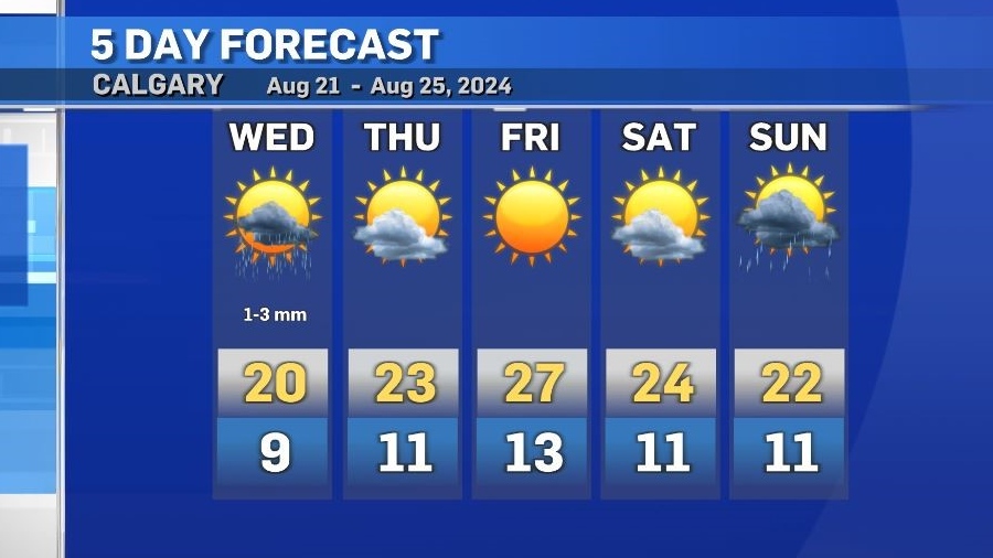
Mid-week dip in temps expected with a return to the above seasonal highs by the weekend

Cooler temperatures are expected in and around Calgary on Wednesday with a good chance of scattered showers and thunderstorms for most of the day, starting in the late morning.
While there is instability, the region lacks the ingredients for organization, so most storms should be non-severe in nature.
The exception being closer to the eastern edge of central and southern Alberta where there is a slight chance of funnel cloud development in the late afternoon/early evening.
Precipitation accumulations in southern Alberta will be mostly minimal Wednesday, Calgary is forecast to receive between 1 to 3 millimetres.
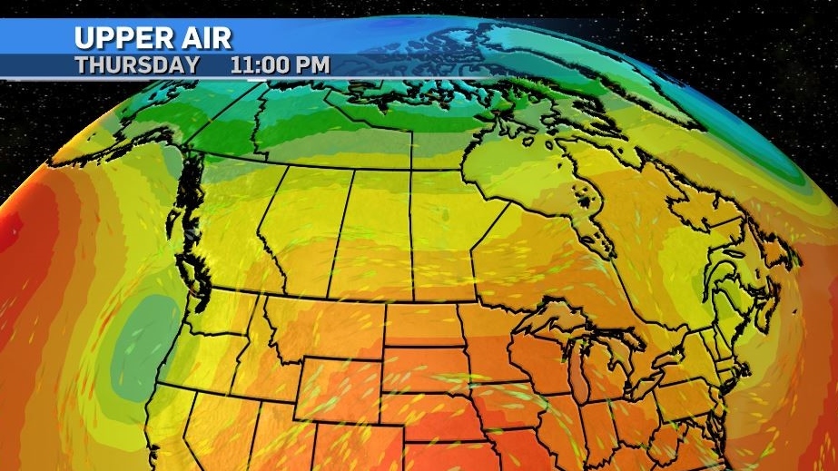
The main weather maker over the next few days will be a low pressure system sinking south along the Pacific coast before settling south of the border where it will remain stalled for a few days.
This is expected to create more of a zonal flow pattern across the Prairies and provide consistency to both the temperatures and conditions.
According to the most recent climate normals data by Environment and Climate Change Canada, August is typically the third wettest month of the year with precipitation (at least 0.2 mm) likely 1 out of 3 days or 33% of days in the month.
As of Aug. 20, some rain has fallen seven days so far this month.


CTVNews.ca Top Stories

'An unfortunate waste of resources': Ontario woman facing criminal charge following water gun incident
A Simcoe, Ont. woman is facing an assault with a weapon charge after she said that she accidentally sprayed her neighbour with a water gun over the Labour Day weekend, a situation that at least one legal expert says amounts to an ‘unfortunate waste of resources.’
What passengers need to know about their rights ahead of a potential Air Canada pilots strike
While Air Canada has shared advice for travellers ahead of a possible pilots strike, an airline passenger rights advocate has more tips for Canadians who may be affected.
Billionaire steps out of SpaceX capsule for first private spacewalk hundreds of miles above Earth
A billionaire kicked off the first private spacewalk Thursday, teaming up with SpaceX on the daring endeavour hundreds of miles above Earth.
Ontario woman misses flight to funeral due to airline ticket typo
An Ontario woman admits she was flustered and stressed trying to book an airline ticket when she found out a close relative had died last month.
Dollarama keeping an eye on competitors as Loblaw launches new ultra-discount chain
Dollarama Inc.'s food aisles may have expanded far beyond sweet treats or piles of gum by the checkout counter in recent years, but its chief executive maintains his company is 'not in the grocery business,' even if it's keeping an eye on the sector.
Consul general to New York to answer questions over $9M luxury condo purchase
After weeks of pressure, Canada's consul general Tom Clark will testify on Thursday before a House of Commons committee about the purchase of his new official residence in New York that generated a lot of political attention over the summer.
OPP constable charged after alleged assault at Santa's Village
A woman has been charged with assault following an incident at an amusement park in Bracebridge.
The U.S. presidential debate opened voters' eyes in suburban Philadelphia, and Harris is getting a closer look
In Bucks County, a critical area in a vital swing state, the debate is producing a lot of hard thinking about what to do in November.
'It's his livelihood': New Brunswick man with cerebral palsy has bottle cart stolen
A New Brunswick community is rallying to replace a man's stolen bottle cart.
Shopping Trends
The Shopping Trends team is independent of the journalists at CTV News. We may earn a commission when you use our links to shop. Read about us.


Edmonton
-

Lloydminster RCMP responding to 'unfolding incident'
Mounties in Lloydminster warned the public they were responding to "an unfolding incident" Wednesday evening.
-
McDavid looking forward after Oilers' run to Stanley Cup final
Connor McDavid attacked the off-season from a different angle.
-
Canada's wildfire season ranks among worst but less severe than feared
With summer drawing to a close in Canada, the 2024 wildfire season is shaping up as one of the most destructive on record, largely due to the devastation caused by a blaze that ripped through a tourist town in the Canadian Rockies.
Lethbridge
-

Interfaith Food Bank puts out call for fresh vegetables, fruit and dairy as harvest season continues
As harvest season continues in southern Alberta, the Interfaith Food Bank in Lethbridge is putting out an urgent call for fresh food and produce.
-
Milk River Emergency Department temporarily closed Thursday
Milk River Emergency Department will be temporarily closed Thursday – but this time it’s not because of a doctor shortage.
-
Lethbridge students struggling to find jobs through the school year
Thousands of students at the University of Lethbridge and Lethbridge Polytechnic are back in Lethbridge for the school year.
Vancouver
-

Family of teen who died in B.C. homeless camp pushes for involuntary treatment for children with addictions
In February, when Brianna MacDonald was rushed to hospital because of a suspected overdose, her parents said they begged Surrey Memorial to keep her in the youth psychiatric ward because of her mental health and addiction issues.
-
Terry Fox's hometown wants public's help with new interactive exhibit
As thousands prepare to take part in Terry Fox Runs this weekend to raise money in the fight against cancer, his hometown has a new legacy project in the works.
-
More people turning to non-profit grocery store as food costs surge
More customers have been shopping the shelves of Vancouver's Quest grocery store.
Vancouver Island
-

B.C. family doctors press parties for plans to address crisis ahead of election
More than 700,000 British Columbians don't have a family doctor and two physicians’ groups want to know how the province’s political parties plan to address the crisis.
-
Family of teen who died in B.C. homeless camp pushes for involuntary treatment for children with addictions
In February, when Brianna MacDonald was rushed to hospital because of a suspected overdose, her parents said they begged Surrey Memorial to keep her in the youth psychiatric ward because of her mental health and addiction issues.
-
RCMP enforcement at B.C. logging protests 'unreasonable,' federal police watchdog says
A federal police oversight agency has found the RCMP's enforcement of a civil injunction against old-growth logging protesters on Vancouver Island was unreasonable and violated the rights of activists.
Saskatoon
-

Saskatoon Tribal Council shelter will face cuts after new proposed shelter opens: province
The proposed downtown location for the city’s newest homeless shelter is drawing criticism from the chief of the Saskatoon Tribal Council (STC), which runs the city’s largest emergency shelter.
-
Councillors endorse Saskatoon downtown planning roadmap
Saskatoon city councillors put their support behind a planning document that is expected to guide the next decade of development for the downtown core at its governance and priorities committee Wednesday.
-
'We do it well': How Elections Saskatchewan preps for voting
Saskatchewan is entering election season, with voters soon heading to the polls to determine the province’s future.
Regina
-

Fire rips through farm field near Pense, farmer outraged over response by emergency crews
All that remains is a black charred field that stretches for miles after a massive fire roared through stubble crop fields in the R.M. of Pense on Monday afternoon.
-
Langenburg UFO sighting commemorated with silver coin
Perhaps Saskatchewan's most famous encounter with Unidentified Aerial Phenomenon (UAP/UFO) – "The Langenburg Event" is now being immortalized in the form of a collective coin.
-
Town of Gravelbourg says goodbye to water tower
For as long as she can remember, 98-year-old Minnie Nugent has enjoyed the view of a water tower in the skyline, welcoming her home to Gravelbourg.
Toronto
-
'An unfortunate waste of resources': Ontario woman facing criminal charge following water gun incident
A Simcoe, Ont. woman is facing an assault with a weapon charge after she said that she accidentally sprayed her neighbour with a water gun over the Labour Day weekend, a situation that at least one legal expert says amounts to an ‘unfortunate waste of resources.’
-
Ontario woman misses flight to funeral due to airline ticket typo
An Ontario woman admits she was flustered and stressed trying to book an airline ticket when she found out a close relative had died last month.
-
'Well above where we should be': It could feel like the low 30s in Toronto over the next few days
Temperatures will feel like they are in the low 30s at times over the next few days as Toronto gets a sustained stretch of above-seasonal conditions.
Montreal
-
-
Police chase through Longueuil leaves officers searching for suspects
Police are searching for a suspect or suspects after a chase resulted in a car crash in Longueuil's Saint-Hubert borough.
-
What passengers need to know about their rights ahead of a potential Air Canada pilots strike
While Air Canada has shared advice for travellers ahead of a possible pilots strike, an airline passenger rights advocate has more tips for Canadians who may be affected.

Atlantic
-

Driver, 15, dies after crashing into power pole, tree in Stellarton, N.S.
A 15-year-old has died after a single-vehicle collision in Stellarton, N.S., early Thursday morning.
-
Tidal power junk: N.S. village wants huge, abandoned moorings moved from fishing area
Residents of a small Nova Scotia community are worried about who will remove four concrete-filled boxcars sitting in their harbour after a tidal power firm collapsed.
-
'Bit of a mess': Construction, population growth causing traffic tie-ups in Halifax
Ongoing construction and population growth are causing traffic woes for Halifax-area drivers.
Winnipeg
-

'She was very honourable': Cathy Merrick lies in state at Manitoba legislature
The sound of sombre song serenaded the halls of the Manitoba legislature Wednesday as Cathy Merrick's casket was brought in for a closed-door ceremony. Merrick died last Friday and was to lie in state Wednesday afternoon to allow the public to pay their respects.
-
Emergency exercise taking place at Winnipeg airport Thursday
People travelling through Winnipeg Richardson International Airport on Thursday may notice a number of emergency personnel on the tarmac – but the Winnipeg Airports Authority (WAA) assures it is just a training exercise.
-
Inside a Manitoba ghost town, a group of ladies works to keep it alive
Abandoned homes line the streets of Lauder, a town that's now a ghost of what it once was. Yet inside, a small community is thriving.
Ottawa
-
'Buy Local': PSAC changes shopping message amid backlash for asking workers to boycott downtown Ottawa businesses
A federal public service union is now encouraging its members to "buy local" and support neighbourhood businesses, one day after a social media post suggested federal workers boycott downtown businesses in an apparent retaliation for the return-to-office mandate.
-
Audit finds issues with apprenticeship program, outsourcing of work in OC Transpo garages
The City of Ottawa's auditor general has found issues within OC Transpo's maintenance facilities surrounding supervision and certification of apprentices and around the outsourcing of some work to other garages.
-
Ottawa sees increase in reports of dog bites and attacks
Ottawa Bylaw Services is looking at improving public education campaigns to inform the public about safety issues associated with vicious dogs, but staff say creating an online registry of dangerous dogs would require a full review of the Animal Care and Control Bylaw.
Northern Ontario
-

Careless driving charge laid in North Bay crash
A Sunday morning crash on Highway 17 resulted in a Powassan driver being charged with careless driving, Ontario Provincial Police say.
-
Public pooping leads to threats charge at northern Ont. campground
An incident involving siblings last weekend in Thessalon, Ont., ended with threats against campground staff and charges for one of the family members.
-
Ontario woman misses flight to funeral due to airline ticket typo
An Ontario woman admits she was flustered and stressed trying to book an airline ticket when she found out a close relative had died last month.
Barrie
-

Missing youth last seen in Mulmur Township
A 16-year-old teenager is missing since September 8.
-
Here's how to avoid the taxi cab scam
South Simcoe Police are cautioning Good Samaritans not to fall for the taxi cab scam.
-
Police investigate fatal hit-and-run on Highway 26 involving transport truck
Police are investigating an alleged hit-and-run after an individual was found dead at the side of the road in Springwater Township early Wednesday morning.
Kitchener
-

How new technology is helping farmers cut costs and save time
New advancements in technology are helping farmers save money and time.
-
Residents stepping up home security in Waterloo Region
In a push to make their homes more secure, a local home surveillance company says more residents are installing security cameras on their properties.
-
Civil lawsuit alleging 'brutal' sexual assault launched against accused in Ont.'s 'Woodland rapist' case
An alleged child predator who was arrested and charged earlier this year is now facing a civil lawsuit in connection with a "brutal" sexual assault in a Toronto area park reported nearly 30 years ago.
London
-

Double fatal crash being investigated in Lambton County
Around 1 p.m. on Wednesday, OPP, fire and EMS responded to a crash between a tractor trailer and a passenger vehicle, at the intersection of Inwood Road and Courtright Line in Brooke-Alvinston.
-
Life-threatening injuries after crash near Western University
One person has been taken to hospital with serious, life-threatening injuries after a crash in London Thursday morning. It happened at the Western University gate on Richmond Street around 6 a.m.
-
Victim taken to hospital with serious injuries following afternoon shooting
The London police are investigating a shooting that took place on Boullee Street in London Wednesday afternoon.
Windsor
-

Memorial left at site of shooting victim in Windsor
A small memorial has been left at the site of a deadly police-involved shooting in the city core last week. Jason west died at the corner of Elliott Street east and Goyeau Street, after being shot by police.
-
Double fatal crash being investigated in Lambton County
Around 1 p.m. on Wednesday, OPP, fire and EMS responded to a crash between a tractor trailer and a passenger vehicle, at the intersection of Inwood Road and Courtright Line in Brooke-Alvinston.
-
Fog cancels buses in Essex County
Fog is expected to dissipate this morning making way for sunshine and a high of 29 C, the humidex making it feel like 34 C.


