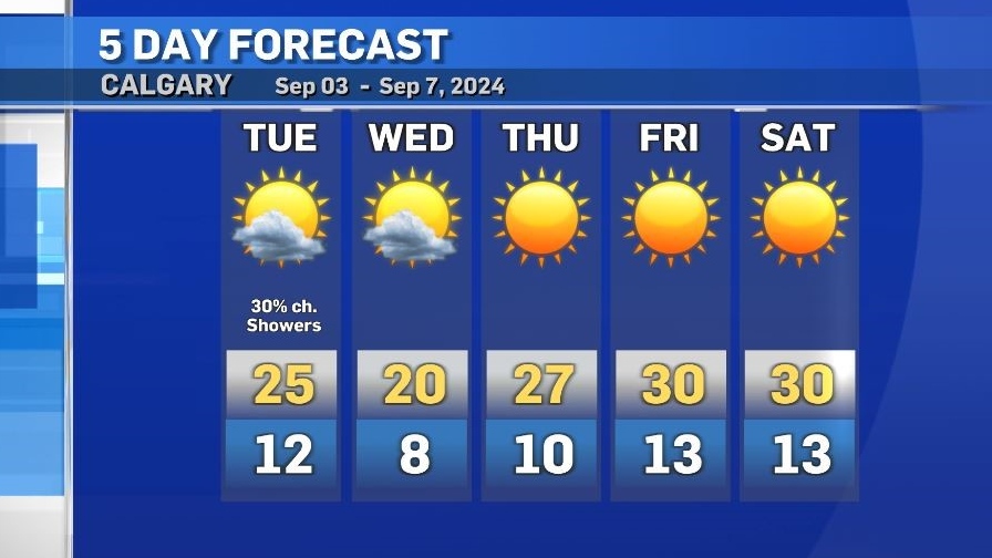
Mildly unsettled start to the week ahead of a hot and dry weekend
Scattered showers and isolated thunderstorms moved through parts of central and southern Alberta Tuesday morning.
This pattern is expected to continue throughout the day with a slight chance of showers in Calgary.
Wednesday will bring increasing cloud with a cooler daytime high, however that high of 20 C is actually average for this time of year.
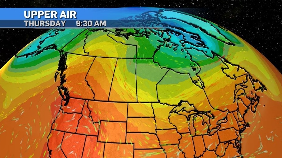
A pattern of hot and dry weather will begin on Thursday when a strong ridge of high pressure moves across the southern B.C. border and into Alberta.
Daytime highs in the region are expected to remain 10 C to 13 C above seasonal for most of the weekend.
In Calgary, highs of 30 C to 33 C are likely with lows around 13 C to 14 C.
Heat warnings may be issued by Environment and Climate Change Canada due to this stretch of unusually warm weather, although overnight lows may struggle to exceed that component of the warning threshold.
For most of Alberta, excluding portions of southern Alberta like Lethbridge, Pincher Creek and Medicine Hat, a heat warning will be issued when daytime highs reach at least 29 C plus daily lows reach at least 14 C for at least two consecutive days.


CTVNews.ca Top Stories

BREAKING
BREAKING Air Canada, pilots reach tentative deal, averting work stoppage
Passengers with plans to fly on Canada's largest airline can breathe a sigh of relief after Air Canada said Sunday it has reached a tentative agreement with the union representing more than 5,200 of its pilots.
Liberals will let Conservatives hold non-confidence vote 'fairly soon', no intention of proroguing Parliament
The Liberals have no intention of using procedural tactics to delay the Conservatives' promised non-confidence motion, and they have no plans to prorogue Parliament to hold onto power, according to Government House Leader Karina Gould.
They came from Jamaica for work, now they're homeless and out thousands of dollars in lost wages
Abuse of Canada’s temporary foreign worker program has left a group of carpenters from Jamaica 'destitute' after an Ottawa company refused to pay them for nearly half a year of work.
Beef with your neighbour? Here are your rights in Canada, according to a lawyer
If you have beef with your neighbour and you feel it's gone too far, what should you do? A personal injury lawyer has some advice.
opinion
opinion Prince Harry turns 40: Reflecting on his milestones and challenges
As Prince Harry turns 40 on Sunday, royal commentator Afua Hagan charts the prince's path which has been defined by significant milestones and challenges from his time at Kensington Palace to his current life in his California mansion.
Andrew Scheer avoids answering if Conservatives will cancel dental care program
Conservative House Leader Andrew Scheer won't say whether his party will scale back or fully scrap Canada's federal dental care program, despite new data showing nearly 650,000 Canadians have used the plan.
Tech billionaire returns to Earth after first private spacewalk
A billionaire spacewalker returned to Earth with his crew on Sunday, ending a five-day trip that lifted them higher than anyone has traveled since NASA's moonwalkers.
Northern Ontario beekeeper says she lost nearly 2 million bees this season
CTV News Northern Ontario provides and update on the story of more than 1.5 million bees be lost earlier this summer.
4 years ago, a 'Trump Train' convoy surrounded a Biden-Harris bus. Was it political violence?
Texas jury will soon decide whether a convoy of supporters of then-U.S. president Donald Trump violently intimidated former Democratic lawmaker Wendy Davis and two others on a Biden-Harris campaign bus when a so-called 'Trump Train' boxed them in for more than an hour on a Texas highway days before the 2020 election.
Shopping Trends
The Shopping Trends team is independent of the journalists at CTV News. We may earn a commission when you use our links to shop. Read about us.


Edmonton
-

1 dead in Edmonton collision involving motorcycle and SUV
An investigation is underway into a Friday afternoon collision that left one man dead.
-
k.d. lang gets the band back together for Canadian country music awards show
The return of k.d. lang and the Reclines is expected to be a highlight as the Canadian Country Music Association hands out its annual hardware tonight in Edmonton.
-
Fugitive wanted in connection with Rocky View County murder arrested
Mounties have captured a fugitive wanted for murder and on the run since early August, and it happened while they were working another case.
Lethbridge
-

Lethbridge police locate man wanted on outstanding warrants
Lethbridge police have located and arrested a man wanted on a number of outstanding warrants.
-
Coaldale man charged with attempted murder after Lethbridge break-and-enter
Lethbridge police say a 28-year-old man is facing charges of attempted murder following a frightening attack on a woman inside her home this week.
-
Police operation near Vauxhall, Alta., ends: RCMP
A police operation in near Vauxhall, Alta. has ended.
Vancouver
-

4 charged with manslaughter, forcible confinement in Burnaby 19-year-old's death: IHIT
More than a year after a Burnaby man was killed during a home invasion, charges have been laid against four suspects for their alleged involvement in the fatal incident.
-
Homes evacuated, road closed after explosive found in North Delta
A pair of homes were evacuated and a stretch of road was closed in North Delta Saturday afternoon after an explosive shell was found abandoned next to a bus stop, local police have confirmed.
-
Road to UBC closing for 2 days due to film shoot
A stretch of road connecting Vancouver and the University of British Columbia campus will be shut down for two days starting Sunday morning to accommodate a film production.
Vancouver Island
-

Victoria man who stole from investors banned from market, BCSC says
A Victoria man who pleaded guilty to theft following an investigation by B.C.'s securities regulator has now been banned from the investment market.
-
4 charged with manslaughter, forcible confinement in Burnaby 19-year-old's death: IHIT
More than a year after a Burnaby man was killed during a home invasion, charges have been laid against four suspects for their alleged involvement in the fatal incident.
-
B.C. Conservatives promise to end stumpage fees, review fire management if elected
British Columbia Conservatives are promising changes they say will bring more "stability" to the province's struggling forestry industry.
Saskatoon
-

'We were scratching our heads': Saskatoon child clinic raises concerns over proposed shelter nearby
There’s more out-cry about a proposed temporary shelter in Saskatoon's downtown core. This time it's from professionals who run a children’s mental health clinic next door, servicing thousands of vulnerable kids each year.
-
RCMP investigating suspicious death after body found in Sask. home
Saskatchewan RCMP major crimes unit is investigating a suspicious death after the body of a 28-year-old man was discovered in a home on Beardy's and Okemasis' Cree Nation.
-
Saskatchewan hospitals report 1,305 service disruptions since 2019, data shows
Data from the Saskatchewan Health Authority (SHA), obtained by the provincial NDP through a freedom of information request, shows that between August 2019 and May 2024, there were more than 200,000 hours of healthcare blackouts at 58 hospitals and health centres, not including Saskatoon and Regina.
Regina
-

Outreach group hosts land-based education session focusing on the role of water
The shoreline of Echo Valley Beach hosted several people looking to learn more about the role water plays in the lives of everyone.
-
'Way ahead of her time': Canada's first female pathologist receives prestigious order
Dr. Frances Gertude McGill is known as Canada’s first female pathologist and her work in forensic pathology has landed her second major title.
-
Moose Jaw fire engulfs home, cause under investigation
The Moose Jaw Fire Department is investigating a fire that “fully engulfed” a home in flames on Friday night.
Toronto
-

Air Canada, pilots still far apart as strike notice deadline approaches
Labour talks between Air Canada and its pilots are approaching a midnight deadline, when either side could trigger the start of a shutdown for Canada's largest airline.
-
'We're at a high degree of spread': What you need to know about COVID-19 in Ontario
As we head into another respiratory illness season, here’s a look at where Ontario stands when it comes to COVID-19 and what you need to know.
-
Police release images of suspect vehicle after woman found shot in car in Mississauga
Police in Peel Region are asking for the public’s help to locate a vehicle after a woman was recently found shot inside a car in Mississauga.
Montreal
-

Montreal bars, restaurants react to Quebec bill to regulate merchant tipping requests
Quebec tabled a bill on Thursday that would regulate how merchants determine suggested tips, forcing businesses to calculate them based on the price before tax. Restaurant staff and management are divided on the policy.
-
Liberal candidate in Montreal byelection says campaign is about her — not Trudeau
In the final stretch of a Montreal byelection campaign widely seen as a referendum on Prime Minister Justin Trudeau’s leadership, the Liberal candidate - Laura Palestini - wants people to focus on her — not her leader.
-
Man punched in the face in downtown Montreal, in critical condition
A man is fighting for his life in hospital after an overnight altercation in the Ville-Marie borough of Montreal.
Atlantic
-

Macdonald Bridge closure leads to heavy traffic congestion in Halifax
The only vehicles on the Macdonald Bridge this weekend belong to work crews, with scheduled maintenance closing the span for the duration of the weekend.
-
New Brunswick fishermen fill St. Andrews Wharf Saturday as they call for change on the water
Fishermen from Lobster Fishing Area 36, which goes from Alma to the American border, filled the waters and the wharf in St. Andrews Saturday during a peaceful protest that calls for change from the DFO.
-
From Germany to Canada: Family makes the move to Middle Musquodoboit, N.S., for farm dream
Lindsay Lake Farms in Middle Musquodoboit, N.S., is celebrating the opening their sustainable farm, and bison herd, to the public after four years of work.
Winnipeg
-

Two people in critical condition after north Winnipeg fire
Three people were hospitalized – two in critical condition – following a fire in Winnipeg’s St. Johns neighbourhood Saturday morning.
-
'We're serving Manitoba's greatest needs': Kinsmen Club of Winnipeg marking 100th anniversary
The Kinsmen Club of Winnipeg held its first meeting on Feb. 20, 1924. The club is marking its 100th anniversary this month.
-
Winnipeg police identify Portage Ave. crash victim
Winnipeg police have identified the pedestrian killed in a fatal crash Friday morning.
Ottawa
-

Ottawa woman dies after battle with pancreatic cancer
An Ottawa woman who raised more than $500,000 for cancer research at the Ottawa Hospital has died after a lengthy battle with pancreatic cancer.
-
kitchen fire in low-rise residential building displaces resident in Carlington
Ottawa Fire Services says one resident has been displaced following a fire that started inside a kitchen in a low-rise residential building in Carlington Friday afternoon.
-
Lotto ticket worth $1 million sold in Ottawa, next draw's jackpot $80 million
Ottawa has a new millionaire after Friday night's draw, as one Maximillion ticket worth $1 million was sold in the capital.
Northern Ontario
-
BREAKING
BREAKING Air Canada, pilots reach tentative deal, averting work stoppage
Passengers with plans to fly on Canada's largest airline can breathe a sigh of relief after Air Canada said Sunday it has reached a tentative agreement with the union representing more than 5,200 of its pilots.
-
Northern Ontario beekeeper says she lost nearly 2 million bees this season
CTV News Northern Ontario provides and update on the story of more than 1.5 million bees be lost earlier this summer.
-
Liberals will let Conservatives hold non-confidence vote 'fairly soon', no intention of proroguing Parliament
The Liberals have no intention of using procedural tactics to delay the Conservatives' promised non-confidence motion, and they have no plans to prorogue Parliament to hold onto power, according to Government House Leader Karina Gould.
Barrie
-

Baycats win Dominico Cup
The Barrie Baycats defeated the Guelph Royals 6-2 in Game 4 of the IBL Finals in Guelph Saturday night to win the Jack and Lynne Dominico Cup.
-
Barrie park renamed in honour of Grzegorz 'Greg' Pierzchala
Dozens of community members came together in Barrie on Saturday to remember the life of Provincial Constable Grzegorz "Greg" Pierzchala by renaming a city park in his honour.
-
Local aviation event inspires young prospective pilots
The Midland chapter of the Canadian Owners and Pilots Association (COPA) offered a free flight experience to local youth on Saturday, hoping to inspire young enthusiasts to eventually become pilots.
Kitchener
-

Sisters finally see the Canadian 'aviation artifact' built by their father nearly 90 years ago
Two sisters have finally been reunited with a plane their father built 90 years ago, that is also considered an important part of Canadian aviation history.
-
Bestival brings music, food and fun to Kitchener’s Belmont Village
The sounds of ukuleles, fiddles, and bagpipes drifted over Kitchener’s Belmont Village as a two day music and arts festival returned.
-
Hog Heaven: Friday the 13th takes over Port Dover, Ont.
The streets of Port Dover roared to life on Friday for a tradition that has been going on for decades.
London
-

One person dead following five vehicle collision in Port Dover
Norfolk OPP say they were on the scene of a five vehicle collision on Blueline Road in Port Dover on Friday evening at around 6:00 p.m.
-
Mustangs fall to Golden Hawks, first loss of the regular season in three years
Early game mistakes hung over the Mustangs on Saturday afternoon when London faced off against the Laurier Golden Hawks in Waterloo.
-
BREAKING
BREAKING Air Canada, pilots reach tentative deal, averting work stoppage
Passengers with plans to fly on Canada's largest airline can breathe a sigh of relief after Air Canada said Sunday it has reached a tentative agreement with the union representing more than 5,200 of its pilots.
Windsor
-

You could be fined up to $4,000 for passing a school bus; how you need to share the road
With lots of local kids heading back to school in recent weeks, motorists are once more sharing the road with school buses.
-
Lauzon congestion prompts concerns from Windsor councillor
A Windsor councillor has raised concerns about traffic congestion on the east end of the city.
-
Experimental lighting in this Halloween attraction will transport you into the 1930's
Scarehouse Windsor opened its doors for the Halloween season on Friday - this popular Halloween attraction is in it’s usual spot on McDougall Street.


