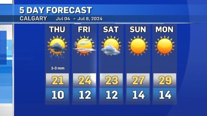
Severe thunderstorms possible Thursday, warmup starts Friday morning
Once again the potential for severe weather exists in central and southern Alberta with multiple shortwave troughs remaining over the region.
Given the right triggers, thunderstorms will fire off of the foothills early in the afternoon Thursday and track in a predominantly west-to-east direction, thanks in part to the influence of an incoming ridge of high pressure.
If thunderstorms do develop today, there is a chance they will undergo rapid intensification – similar to what happened on Tuesday.
The greatest risks include high rainfall rates, larger hail and strong winds.
Things should clear out overnight, leaving Calgary with mild conditions Friday morning for the Calgary Stampede parade.
That incoming ridge of high pressure from the Pacific Northwest will encounter a blocking pattern – stalling the ridge along the southern west coast, and extending north toward the western territories.
Daytime highs in B.C. are expected to reach record temperatures by this weekend and, in Calgary, temps will slowly trend up for the next seven to 10 days, until daytime highs reach at least 10 C above seasonal.
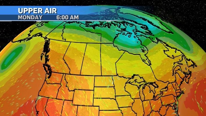
The risk of rain after Thursday will be linked to daytime heating triggering storms as opposed to the past few days when storms were the result of colliding air masses and synoptic ingredients.
Average temperatures in Calgary range from 22 C (daily maximum) and 9 C (daily minimum).
Calgary Top Stories
-
-
-
 ANALYSIS
ANALYSIS Why are Trudeau and Singh avoiding Stampede this year?
-
-
-
-
-


CTVNews.ca Top Stories

Woman dies at Rolling Stones concert in Vancouver
A woman attending the Rolling Stones concert at BC Place died Friday night, police confirmed.
Terrorism charges laid against B.C. woman who married ISIS fighter
A B.C. woman who was repatriated from a Syrian prison camp in 2022 has been arrested and charged with terrorism offences, police announced Saturday.
This Italian vacation hotspot is turning tourists away as it runs out of water
Set atop a hill on the Italian island of Sicily, Agrigento is a heritage tourist’s paradise. But the aqueduct, and others built in modern times, are running so dry that small hotels and guesthouses in the city and nearby coast are being forced to turn tourists away.
Jon Landau, Oscar-winning 'Titanic' and 'Avatar' producer, dies at 63
Jon Landau, an Oscar-winning producer who worked closely with director James Cameron on three of the biggest blockbusters of all time, 'Titanic' and two 'Avatar' films, has died. He was 63.
Radio host who interviewed Biden says aides provided questions in advance
U.S. President Joe Biden’s team provided a list of questions to a radio host who interviewed the president this week in the aftermath of his debate performance, the host told CNN.
ANALYSIS
ANALYSIS Why are Trudeau and Singh avoiding Stampede this year?
This year, only Conservative leader Pierre Poilievre will be saddling up for the event, while both Prime Minister Justin Trudeau and NDP leader Jagmeet Singh will stay away.
Here are some safety tips if you're travelling alone this summer
Though travelling by yourself can be scary and intimidating, there are some ways to make sure you’re safe and have a good time, says a solo travel and content creator from Ottawa.
Saskatoon man charged for leaving hate comments on woman’s obituary pleads guilty
The man who left hate comments on a murder victim’s online obituary has been sentenced.
Alleged accomplice of Quebec gang leader Dave 'Pic' Turmel arrested in B.C.
Another alleged accomplice of the leader of the Blood Family Mafia (BFM), Dave 'Pic' Turmel, has been arrested by the RCMP.
Shopping Trends
The Shopping Trends team is independent of the journalists at CTV News. We may earn a commission when you use our links to shop. Read about us.


Edmonton
-

2 firms offering auto insurance to pull out of Alberta market
Two insurance providers in Alberta have announced plans to stop offering automobile insurance to customers in the province.
-
Serious crash affects traffic on Highway 43 in Grande Prairie
Traffic on Highway 43 in Grande Prairie was affected by a serious crash Saturday afternoon.
-
Mill Creek pool rehabilitated and ready to reopen after 4 years
Mill Creek Pool will reopen Monday after more than four years.
Lethbridge
-

2024 Southern Alberta Summer Games kick off in Coaldale
Nearly 2,000 athletes will compete in 20 events over four days during the 2024 Southern Alberta Sumer Games. After months of planning, organizers are thrilled to welcome families from all over southern Alberta to Coaldale, Alta.
-
Court hears accused in Coutts blockade thought protest could lead to 'war'
One of two men accused of conspiring to kill Mounties at the border blockade at Coutts, Alta., characterized the protest as a last stand and told his mother there “will be a war” if police moved in.
-
Fire ban ended for Lethbridge area
With the recent moisture and cooler temperatures, fire bans and restrictions in the Lethbridge area are no longer in effect.
Vancouver
-

Terrorism charges laid against B.C. woman who married ISIS fighter
A B.C. woman who was repatriated from a Syrian prison camp in 2022 has been arrested and charged with terrorism offences, police announced Saturday.
-
Woman dies at Rolling Stones concert in Vancouver
A woman attending the Rolling Stones concert at BC Place died Friday night, police confirmed.
-
Vancouver cooling centres opened as heat wave hits B.C.
Cooling centres in Vancouver opened Saturday as B.C. began to experience its first widespread heatwave of the summer.
Vancouver Island
-
Terrorism charges laid against B.C. woman who married ISIS fighter
A B.C. woman who was repatriated from a Syrian prison camp in 2022 has been arrested and charged with terrorism offences, police announced Saturday.
-
Whale researcher says orphan orca 'likely' seen off Vancouver Island at Friendly Cove
A killer whale calf whose struggle for survival captured international headlines when she became trapped in a Vancouver Island tidal lagoon earlier this year only to escape on her own has likely been spotted swimming further south along British Columbia's coast.
-
Kittens burned in Vancouver Island wildfire on the road to recovery
A litter of tiny kittens that were rescued in the aftermath of a wildfire on Vancouver Island last month are now recovering in foster care and will be up for adoption soon, the BC SPCA said in an update.
Saskatoon
-

Woman and child killed and four injured in Sask. Highway 4 collision
Two people have died and four people were injured in a fatal collision on Highway 4 on Friday.
-
Three people dead in 2 vehicle collision in Sask.
Three people are dead following a collision between a truck and a van on Highway 4 near Cochin, Sask. on Friday.
-
Saskatoon man charged for leaving hate comments on woman’s obituary pleads guilty
The man who left hate comments on a murder victim’s online obituary has been sentenced.
Regina
-
Three people dead in 2 vehicle collision in Sask.
Three people are dead following a collision between a truck and a van on Highway 4 near Cochin, Sask. on Friday.
-
Woman and child killed and four injured in Sask. Highway 4 collision
Two people have died and four people were injured in a fatal collision on Highway 4 on Friday.
-
Car enthusiasts gather to bid on collector vehicles at annual weekend auction
Coast2Coast Collector Car Auctions held their fourth annual car auction event Saturday.
Toronto
-

Stabbing in Mississauga school parking lot leaves woman dead; one person in custody
A woman is dead, and a man is in custody after a stabbing outside a school in Mississauga.
-
One person critically injured in Scarborough shooting
Toronto police say one person has been critically injured in a shooting in Scarborough.
-
Up to 7 teens with pellet guns shot at people at Woodbine Park: police
Multiple people have been shot by a group of teenagers with pellet guns at Woodbine Park, Toronto police say.
Montreal
-

Quebec pharmacists may soon have more powers: What are they?
Pharmacists in Quebec can treat certain minor health problems or offer preventative treatments.
-
Montreal police make 1 arrest, deploy tear gas after protesters smash windows at McGill
One person was arrested Friday evening after police deployed tear gas to disperse a crowd of pro-Palestinian protesters at McGill University.
-
Alleged accomplice of Quebec gang leader Dave 'Pic' Turmel arrested in B.C.
Another alleged accomplice of the leader of the Blood Family Mafia (BFM), Dave 'Pic' Turmel, has been arrested by the RCMP.
Atlantic
-

Picture-perfect greens on display at Mactaquac as organizers prepare for PGA Tour Americas tournament
It's an orchestra of lawn trimmers, mowers and golf carts at Mactaquac Provincial Park as organizers prepare to welcome over 150 professional golfers to their greens for the PGA Tour Americas.
-
Cavendish Beach Music Festival continues rain or shine
The largest multi-day outdoor music festival in Atlantic Canada has officially kicked-off, with some of the biggest names in country music visiting our region.
-
N.B. man dead after Jet Ski and recreational boat collision in Petit-Tracadie
New Brunswick RCMP says a man has died following a collision between a Jet Ski and recreational boat on the Tracadie River in Petit-Tracadie.
Winnipeg
-

Have you seen Johnny? WPS search for 24-year-old man
The Winnipeg Police Service (WPS) is asking for the public’s help in finding 24-year-old Johnny Arragutainaq.
-
The story behind a truck covered in teacups in Brandon
If you’re ever visiting Brandon, Man., you might want to pay a visit to Talia. She’s beautiful, delicate, and a true work of art.
-
Winnipeg man faces over 20 charges in stolen vehicle, property investigation
A Winnipeg man is facing more than 20 charges after an off-duty RCMP officer discovered a stolen vehicle parked in front of a home in the city’s Brooklands neighbourhood.
Ottawa
-

Ottawa man using walker says apartment not accessible, with no answer in sight
An Ottawa man living in the city’s south-end says he’s struggling to get his walker through the front door of his apartment and wants the building’s owner to install an automatic door button.
-
Ottawa man, 28, dead after shooting in Westboro, police investigating
The Ottawa Police Service is investigating following a shooting that left one man dead Friday in Westboro.
-
Stunt driver caught speeding nearly 90 km/h over speed limit in Barrhaven
The Ottawa Police Service clocked a driver speeding to nearly 90 km/h over the posted speed limit in Barrhaven on Friday night as police continue to target high-risk drivers in the city.
Northern Ontario
-

Large pile of lobster dumped on the side of Hwy. 17 in northern Ontario
Ontario Provincial Police are investigating after a pile of dead lobster was found on the shoulder of Highway 17 this week in northern Ontario.
-
Terrorism charges laid against B.C. woman who married ISIS fighter
A B.C. woman who was repatriated from a Syrian prison camp in 2022 has been arrested and charged with terrorism offences, police announced Saturday.
-
ANALYSIS
ANALYSIS Why are Trudeau and Singh avoiding Stampede this year?
This year, only Conservative leader Pierre Poilievre will be saddling up for the event, while both Prime Minister Justin Trudeau and NDP leader Jagmeet Singh will stay away.
Barrie
-

Irish Mythen, Noah Cyrus headline Mariposa Day 2
The Irish-Canadian folk artist and Billy Ray Cyrus' youngest daughter take the stage Saturday night at the Mariposa Folk Festival.
-
Bradford African festival showcases culture, food, community
The African Experience welcomed hundreds to the Bradford West Gwillimbury Public Library for a celebration of Black and African culture.
-
Local great-grandmother celebrates 100th birthday
Mary Buratynsky celebrated her centurion birthday with family and friends in Springwater on Saturday afternoon.
Kitchener
-
Occupy UW agrees to end encampment, University of Waterloo to withdraw injunction
The pro-Palestinian encampment that's been on the University of Waterloo's campus for nearly two months is expected to be gone by Sunday evening.
-
Southwestern Ont. alpaca farmers call for more wool processing resources in province
Southwestern Ontario alpaca farmers are calling for more wool processing resources in the province.
-
How local alcohol businesses are reacting to LCBO strike
Locally-owned alcohol businesses are making adjustments to attract more customers while LCBO workers across the province are on strike.
London
-

Amid threat from Western University, protesters remove encampment after two months
After threats by Western University to dismantle before the end of the weekend, the pro-Palestine encampment on campus has come down.
-
VIDEO: Three businesses damaged in Kincardine fire
A fire has caused extensive damage to at least three businesses in Kincardine Saturday morning.
-
Police continue search for missing man on two-year anniversary
The Sarnia Police Service (SPS) continues its search for a man who has been missing for two years.
Windsor
-

Harrow family of four died from gunshot wounds in case of intimate partner violence, OPP say
Investigators have determined that the deaths of four family members in Harrow in June were the result of intimate partner violence, with three dying from gunshot wounds and one from a self-inflicted gunshot wound.
-
Police reveal Windsor's most collision-prone intersection in last 15 months
In the last 15 months, the stretch of road in front of Devonshire Mall leading to the E.C Row Expressway ramps has become the most collision-prone area for drivers in Windsor.
-
VIDEO
VIDEO Local pizza maker nominated for world's 100 best wants Windsor 'at the table' with New York and Chicago pizza
After earning awards for Canada's best pizza chef in Canada and top-five positions in competitions across North America, Dean Litster is in the running to be recognized on an international stage.


