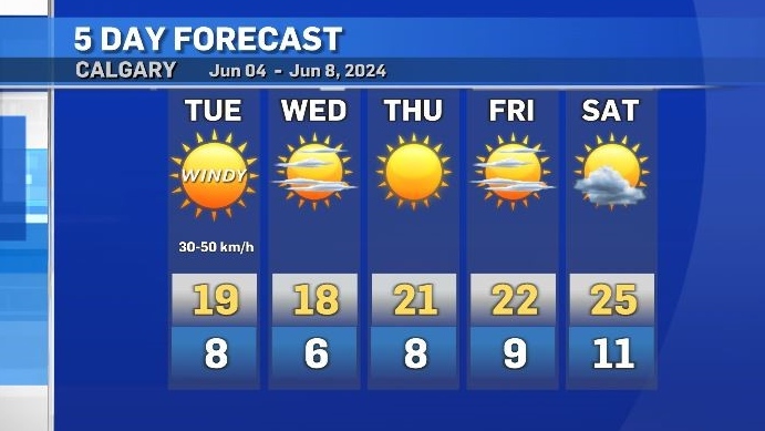
Windy Tuesday in southern Alberta with isolated thunderstorms possible
Tuesday would best be described as a transitional day for Calgary and area.
A low pressure system in central Saskatchewan is continuing to influence southern Alberta’s weather along the trailing cold front within the associated long wave trough.
In northern Alberta light and steady rain is expected Tuesday – also linked to that strong Saskatchewan low, whereas the bulk of central and southern Alberta (south of the Yellowhead Highway) should stay dry.
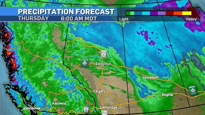
An incoming ridge of high pressure from the Pacific is going to help drive that low east, but as that ridge crosses the Rockies, wind gusts will be noticeable.
In Calgary, westerly winds of 20 to 40 kilometres per hour will increase to 30 to 50 kilometres per hour in the afternoon Tuesday, with wind gusts closer to 80 kilometres per hour in the southernmost portions of the province.
That same westerly flow will widen the dewpoint depression near the foothills and enhance the likelihood of thunderstorms firing east of the responding dryline and west of the trailing trough later Tuesday.
By Thursday, a more consistent weather pattern will bring a longer stretch of stability with warmer temperatures in southern Alberta and B.C. Daytime highs in southern Alberta should stay in the low to mid 20s until at least early next week.


CTVNews.ca Top Stories

Calls for change to B.C.'s child protection system after disturbing case of neglect
Is B.C.'s child protection system outdated and in need of a major overhaul? The province's representative for children and youth believes so, and that 'a new model' is needed.
Ont. mother loses $6K during Facebook marketplace transaction
An Ontario woman is sharing her story after she lost $6,000 by clicking a fraudulent link disguised to look like an e-transfer during a Facebook Marketplace transaction.
Rapper Travis Scott arrested for disorderly intoxication, trespassing early Thursday
American rapper Travis Scott, whose legal name is Jacques Bermon Webster, was arrested and booked into Miami-Dade County Jail early Thursday morning, county jail records show.
Manitoba hit with five tornadoes last week
Tornado season entered Manitoba with a bang last week.
Train collision in Chile kills at least 2 people and injures 9 others
At least two people were killed and nine others injured Thursday when a train full of passengers collided head-on with another train on a test run just outside the capital of Chile, where fatal railway crashes remain rare.
Senators approve bill to fight foreign interference after voting down amendment
The Senate has passed a government bill intended to help deter, investigate and punish foreign interference.
Gunman in Toronto shooting was not evil, but 'broken' by fraud dispute: wife
The wife of the gunman in Monday's double murder-suicide in North York says she doesn't consider her husband an evil person, but one who was 'broken' by a lengthy fraud dispute that saw their family savings drained.
Illegally brewed liquor kills at least 34 with dozens hospitalized in southern India
At least 34 people have died and dozens hospitalized after drinking illegally brewed liquor in the southern Indian state of Tamil Nadu, local media reported on Thursday.
Heat warnings blanket the east and in Northwest Territories; humidex temperatures push the mid-40s
Heat warnings blanket Canada's eastern corridor Thursday as the year's first major heat wave drags on, and even parts of Northwest Territories are feeling the burn.
Shopping Trends
The Shopping Trends team is independent of the journalists at CTV News. We may earn a commission when you use our links to shop. Read about us.


Edmonton
-

What can Brown do for the Oilers? Edmonton's other Connor is thriving in the Stanley Cup Final
There is no doubt Connor McDavid is the biggest reason the Edmonton Oilers have made it a series in the Stanley Cup Final against the Florida Panthers. Their other Connor has played a crucial role in the comeback bid, too.
-
1 hospitalized after rollover on 76 Avenue
Emergency crews were called to a rollover in east Edmonton early Thursday morning.
-
WEATHER
WEATHER Josh Classen's forecast: Summer starts and so does a warm spell
It's the summer solstice, our "longest day" of the year (most daylight).
Lethbridge
-

More students looking for summer jobs leads to competitive market
It wasn't long ago many businesses were struggling to hire enough people to meet their staffing needs...
-
Alberta seniors to get 25% discount on driver’s medical exam
Seniors in Alberta will get a break if they need a medical exam to renew their driver’s licence.
-
Lethbridge Fire and EMS refresh river rescue training ahead of summer
With summer nearing, many will be finding ways to beat the heat, including taking a float down the Oldman River, and that has Lethbridge Fire and Emergency Services (LFES) refreshing their water skills.
Vancouver
-

Vancouver council votes to densify upscale Shaughnessy neighbourhood
Vancouver council voted in favour of densifying the upscale neighbourhood of Shaughnessy this week, which could result in several housing units being developed on a single lot.
-
Portion of Vancouver tenants spending half their income on rent: report
The path to homeownership in Vancouver is becoming increasingly out-of-reach for many renters.
-
Calls for change to B.C.'s child protection system after disturbing case of neglect
Is B.C.'s child protection system outdated and in need of a major overhaul? The province's representative for children and youth believes so, and that 'a new model' is needed.
Vancouver Island
-

Poor use of B.C. taxpayer dollars or necessary health-care expense? Critics slam secrecy and soaring costs
A day after CTV News was first to report British Columbia’s health authorities have more than doubled their payments to for-profit staffing agencies, there’s growing outrage at the taxpayer dollars going to a “parasitic industry.”
-
Feds delay B.C.'s open-net salmon farms closure until 2029, offer five-year renewals
With entrenched views on all sides of the salmon-farming debate in British Columbia, the federal government cast the issue five years down the road on Wednesday, saying aquaculture must move to land by 2029.
-
B.C. police complaint commissioner investigating sexual misconduct allegations against Vancouver police sergeant
A veteran sergeant with the Vancouver Police Department is under investigation by the B.C. police complaint commissioner following allegations of sexual misconduct from seven women, including female police officers and former students of his criminal justice courses.
Saskatoon
-

Sask. entrepreneur launches recycling pickup service, Reroute
A new service in Saskatoon aims to eliminate the hassle of getting recycling to the right places.
-
Sask. beekeeper remains optimistic after warm winter gives way to rough spring
A Saskatchewan beekeeper is staying optimistic after a warm winter that provided some great conditions for bee production.
-
Saskatoon’s father and son race for epic prize on Amazing Race Canada
A father son duo from Saskatoon are set to appear on season 10 of The Amazing Race Canada.
Regina
-

One dead following Swift Current house fire
One person was found dead following a house fire in Swift Current late Tuesday night.
-
'Sight to behold': U.S. Air Force cargo jet lands in Regina
Regina's International Airport hosted a true aerial behemoth late last week – courtesy of the United States Air Force (USAF).
-
Several cats, dog rescued from Regina house fire
Several cats and a dog were rescued from a house fire on the 2600 block of Lindsay Street on Wednesday.
Toronto
-

Gunman in Toronto shooting was not evil, but 'broken' by fraud dispute: wife
The wife of the gunman in Monday's double murder-suicide in North York says she doesn't consider her husband an evil person, but one who was 'broken' by a lengthy fraud dispute that saw their family savings drained.
-
Ont. mother loses $6K during Facebook marketplace transaction
An Ontario woman is sharing her story after she lost $6,000 by clicking a fraudulent link disguised to look like an e-transfer during a Facebook Marketplace transaction.
-
Strawberry Moon: What is it and where can you see it in Ontario?
Summer is officially here and this year a rare full moon will mark the occasion with a name that couldn’t be more fitting.
Montreal
-

Severe thunderstorm watch in effect for Montreal area
Environment Canada has issued a severe thunderstorm watch for several regions in Quebec as heat warnings remain in effect for much of the province.
-
City worker discovers body in canal southwest of Montreal, Quebec police investigating
Quebec police (SQ) are investigating after a city worker discovered a dead body in a canal west of Montreal.
-
A mural in tribute to René Lévesque to be created this summer in Montreal
A 'large-scale mural' in tribute to former premier René Lévesque will be completed this summer in Montreal. Once completed, it will be visible to motorists on the Metropolitan Expressway (A-40).
Atlantic
-

Heat warnings blanket the east and in Northwest Territories; humidex temperatures push the mid-40s
Heat warnings blanket Canada's eastern corridor Thursday as the year's first major heat wave drags on, and even parts of Northwest Territories are feeling the burn.
-
N.S. RCMP searching for wanted man in Musquodoboit Harbour who may be armed
The Nova Scotia RCMP says there is a heavy police presence in the Musquodoboit Harbour area as they search for a man on a provincewide warrant who may be armed.
-
MacKay Bridge to stay open this weekend: Halifax Harbour Bridges
Halifax Harbour Bridges says a planned closure of the A. Murray MacKay Bridge will not go forward this weekend due to rain in the forecast.
Winnipeg
-

Manitoba hit with five tornadoes last week
Tornado season entered Manitoba with a bang last week.
-
Three Manitoba credit unions approve merger
The member-owners of three major Manitoba credit unions have voted in favour of a merger
-
More details coming on Prairie Green landfill search
The Manitoba government will share more details on how they plan to search a landfill where the remains of two Indigenous women are believed to be located.
Ottawa
-

Mayor criticizes decision to close Pimisi Station to O-Train riders on Canada Day
Mayor Mark Sutcliffe is criticizing the decision by security officials to limit access to the O-Train Pimisi Station on Canada Day, insisting the decision is "about traffic flow" to the events at LeBreton Flats and not capacity issues at the station.
-
HEAT WARNING
HEAT WARNING A hot and humid start to summer in Ottawa: Here's when relief from the heat warning will arrive
Environment Canada's heat warning remains in effect for the city of Ottawa, with the weather agency saying the "prolonged heat event continues today with dangerously hot and humid conditions expected."
-
Motorists could have to pay for on-street parking in Wellington West and Westboro
A report for the transportation committee recommends councillors approve the introduction of paid on-street parking next spring on sections of Richmond Road, Wellington Street West, Somerset Street West, Danforth Avenue, Churchill Avenue and Holland Avenue.
Northern Ontario
-

Ont. mother loses $6K during Facebook marketplace transaction
An Ontario woman is sharing her story after she lost $6,000 by clicking a fraudulent link disguised to look like an e-transfer during a Facebook Marketplace transaction.
-
Ontario’s Ministry of Labour charged with criminal negligence causing death in Sudbury, Ont., mining fatality
Ontario’s Ministry of Labour and one of its employees have been charged with criminal negligence causing death in connection with a 2006 mining fatality in the Sudbury area.
-
Police say northern Ont. suspect resold $94K in rented equipment after removing GPS
A 47-year-old suspect from Powassan, Ont., has been charged with fraud and drug offences, as well as for participating in a criminal organization.
Barrie
-

Heat wave continues for Barrie, Midland and Orillia
Environment Canada has issued another heat wave warning for Simcoe County.
-
Caledon and Schomberg drug busts net cops more than drugs
Three men were charged during execution of search warrants at two properties in Schomberg and Caledon.
-
'Suspicious person' arrested for stunt driving
Police received a call about a suspicious person in Caledon Saturday.
Kitchener
-

Happy ending for dog found in outhouse holding tank in Guelph, Ont.
Cleo the dog has a new home after it was found starving and covered in human waste at a conservation area in Guelph, Ont.
-
Landowners protest at regional headquarters over Wilmot land deal
About two dozen people gathered outside of the Region of Waterloo headquarters on Wednesday evening, to protest the region’s controversial bid to acquire 770 acres of Wilmot farmland.
-
Baden high school students 'can’t even focus' dealing with lack of air conditioning
Students at Waterloo-Oxford District Secondary School are struggling with the lack of air conditioning in some parts of the Baden school.
London
-

Constructors Cup comes up big to support London’s whole of community system response
The recent Constructors Cup charity soccer tournament presented by The London Home Builders’ Association (LHBA) raised $70,000, which will be put towards the implementation of London’s whole of community system response to the crisis of homelessness in our community.
-
Crews respond to engulfed structure in Norfolk County
Norfolk Street in Simcoe is closed between 14th Street east and Davis Street. Drivers are asked to use an alternate route this morning.
-
Cyclist dies after crash in east London
London police say a 54-year-old cyclist has died after a crash in the city’s east end.
Windsor
-

Man arrested for assaulting youth: Chatham-Kent police
Just before 9 p.m. on Wednesday, police were called to King Street east where they said a youth was riding a scooter through a parking lot, when a man began to yell.
-
Buses destroyed by fire in Essex County
According to AM800 news, it happened early Wednesday evening at a bus yard in the 2000-block of Naylor Sideroad near Maidstone Avenue East.
-
'The heat makes everybody cranky': Windsor refugee centre appealing for relief after air conditioners go on the fritz
Three out of four air conditioners at Matthew House in Windsor on Forest Glade Drive have stopped working in the midst of an extended extreme heat wave across all of southwestern Ontario.


