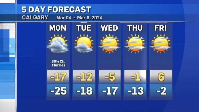
Mondays daytime high will be 19 C colder than normal
Crews are continuing to work on clearing roadways after a massive snowfall hit southern Alberta over the weekend.
According to Environment and Climate Change Canada (ECCC) Calgary saw varying totals, ranging from eight centimetres to 23 centimetres across the city, with 18 centimetres as the official event total measured at the Calgary International Airport.
Well-situated high and low pressure systems produced narrow bands of snow, which – west of Calgary - combined with strong winds to produce whiteout conditions along the Trans-Canada highway on Thursday.
Mountain regions west of Calgary received up to 40 centimetres of snow over the weekend and some communities east of Calgary also recorded high snowfall totals, including Gleichan with total accumulations of 34 centimetres and Drumheller at 23 centimetres.
Further south and east, communities like Lethbridge and Medicine Hat were not as impacted with five and two centimetres respectively.
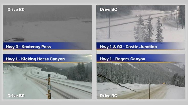
Mountain highways visible on the Drive BC website on Monday morning were still showing snow-covered routes.
A low complex (an area of low pressure with multiple centres) will continue to pull colder air into Alberta for the next couple of days. The daytime high in Calgary on Monday will be 19 degrees colder than average and the high on Tuesday will be 14 degrees colder than average.
Overnight low temperatures will range from -17 C to -25 C over the next few nights with wind chill values making it feel colder than that.
As of 9 a.m. Monday an extreme cold warning remains in place north and east of Calgary, due to wind chill values close to -40 at times.
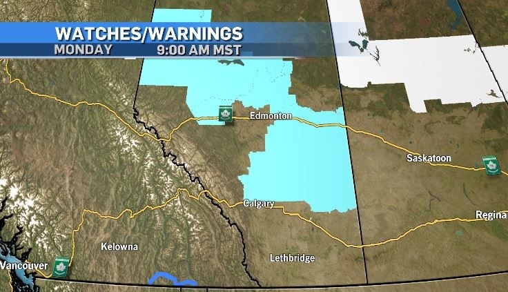 Extreme cold warnings (teal) from ECCC remain in place on Monday, March 4, 2024. A winter storm warning (blue) was issued for southern British Columbia, and snowfall warnings (white) for northern Saskatchewan and Manitoba.
A ridge of high pressure will introduce warmer Pacific air into southern Alberta starting on Wednesday, with daytime highs expected to hit the mid-single digits by Friday. Calgary will see more sunshine starting on Tuesday, but melting is unlikely until Wednesday when the daytime high hits -5 C.


CTVNews.ca Top Stories

Canadian former Olympic snowboarder wanted in Ontario double homicide: DOJ
A Canadian former Olympic snowboarder who is suspected of being the leader of a transnational drug trafficking group that operated in four countries is wanted for allegedly orchestrating the murder of an 'innocent' couple in Ontario in 2023, authorities say.
Ontario school board trustees under fire for $100K religious art purchase on Italy trip
Trustees with an Ontario school board are responding to criticism over a $45,000 trip to Italy, where they purchased more than $100,000 worth of religious statues.
A photographer snorkeled for hours to take this picture
Shane Gross, a Canadian marine conservation photojournalist, has won the title of Wildlife Photographer of the Year.
Tobacco giants would pay out $32.5 billion to provinces, smokers in proposed deal
Three tobacco giants are proposing to pay close to $25 billion to provinces and territories and more than $4 billion to some 100,000 Quebec smokers and their loved ones as part of a corporate restructuring process triggered by a long-running legal battle.
More Trudeau cabinet ministers not running for re-election, sources say shuffle expected soon
Federal cabinet ministers Filomena Tassi, Carla Qualtrough and Dan Vandal announced Thursday they will not run for re-election. Senior government sources tell CTV News at least one other, Marie-Claude Bibeau, doesn't plan to run again, setting the stage for Justin Trudeau to shuffle his cabinet in the coming weeks.
Robert Pickton's handwritten book seized after his death in hopes of uncovering new evidence
A handwritten book was seized from B.C. serial killer Robert Pickton's prison cell following his death earlier this year, raising hopes of uncovering new evidence in a series of unprosecuted murders.
Former members of One Direction say they're 'completely devastated' by Liam Payne's death
The former members of English boy band One Direction reacted publicly to the sudden death of their bandmate, Liam Payne, for the first time on Thursday, saying in a joint statement that they're 'completely devastated.'
Israel says it has killed top Hamas leader Yayha Sinwar in Gaza
Israeli forces in Gaza killed top Hamas leader Yahya Sinwar, a chief architect of last year's attack on Israel that sparked the war, the military said Thursday. Troops appeared to have run across him unknowingly in a battle, only to discover afterwards that a body in the rubble was Israel's most wanted man.
Indian government employee charged in foiled murder-for-hire plot in New York City
The U.S. Justice Department announced criminal charges Thursday against an Indian government employee in connection with a foiled plot to kill a Sikh separatist leader living in New York City.
Shopping Trends
The Shopping Trends team is independent of the journalists at CTV News. We may earn a commission when you use our links to shop. Read about us.


Edmonton
-

Drowning death of 5-year-old at Wabamun Lake believed to be criminal: RCMP
RCMP are looking for witnesses in what they believe was the criminal death of a five-year-old girl at Wabamun Lake on Sunday.
-
Edmonton education support staff vote overwhelmingly in favour of strike action
Edmonton education support staff could be heading to the picket lines.
-
Suspects in targeted Duggan shooting sought by Edmonton police
Edmonton police are hoping the public can help identify people involved in a shooting in the southside neighbourhood of Duggan last month.
Lethbridge
-

Field of Screams transforms Spitz Stadium into something frightful for a good cause
With Halloween just around the corner, the Lethbridge Bulls staff have been hard at work getting Spitz Stadium ready for a different sort of fall classic.
-
Lethbridge post-secondary schools dealing with impact of international student cap
Lethbridge post-secondary schools are trying to navigate recent changes to the cap on international students, announced by the federal government in January.
-
‘Game-changer’: funding for new K-12 school on Piikani Nation announced
More than 600 students on the Piikani Nation will soon have a new space to learn after the federal government announced funding Thursday morning.
Vancouver
-

David Eby vs. Chip Wilson: B.C. NDP leader slams billionaire's latest contribution to pre-election discourse
B.C. NDP Leader David Eby slammed his billionaire constituent Chip Wilson – again – on the campaign trail, following the publication of an op-ed by the Lululemon founder.
-
B.C. south and central coast under flood watch as atmospheric river approaches
Forecasters have elevated their warnings about an atmospheric river system that is expected to hit coastal British Columbia on Friday, bringing potential flooding, heavy rain and high winds.
-
Real estate agent submitted 'falsified' financial information on mortgage applications, B.C. regulator finds
The agency that regulates real estate agents in B.C. has cancelled the licences of a man and his personal real estate corporation after he admitted to using an unregistered mortgage broker and submitting "falsified income and savings information" on two mortgage applications.
Vancouver Island
-
David Eby vs. Chip Wilson: B.C. NDP leader slams billionaire's latest contribution to pre-election discourse
B.C. NDP Leader David Eby slammed his billionaire constituent Chip Wilson – again – on the campaign trail, following the publication of an op-ed by the Lululemon founder.
-
B.C. south and central coast under flood watch as atmospheric river approaches
Forecasters have elevated their warnings about an atmospheric river system that is expected to hit coastal British Columbia on Friday, bringing potential flooding, heavy rain and high winds.
-
CP Railway adjusts safety measures following B.C. train crash: safety board
The Transportation Safety Board says a mistake by a Canadian Pacific Railway supervisor set off a crash between a freight train and a railway work vehicle in Cache Creek, B.C.
Saskatoon
-

5-day-old baby found safe after Amber Alert cancelled, suspect in custody
An Amber Alert issued by Waskesiu Lake RCMP for a 5-day-old baby boy has been cancelled.
-
Saskatoon mayoral candidate Cary Tarasoff unveils financial platform with critiques of city spending
Saskatoon mayoral candidate Cary Tarasoff says it's time for the city to get its finances back on track after building a reputation of overspending and mismanaging costly projects.
-
Police investigating after human remains found in Prince Albert
The Prince Albert Police Service is investigating after unidentified human remains were found in the city.
Regina
-
5-day-old baby found safe after Amber Alert cancelled, suspect in custody
An Amber Alert issued by Waskesiu Lake RCMP for a 5-day-old baby boy has been cancelled.
-
Sask. Party leader promises to swiftly introduce school changeroom policy if re-elected
Saskatchewan Party Leader Scott Moe announced Thursday that if re-elected his party's 'first order of business' would be to introduce a policy that would ban 'biological males' from changing with 'biological females' in school changerooms.
-
Yorkton Chamber hosts provincial forum
Yorkton’s Chamber of Commerce hosted an “All Candidates Forum” Wednesday evening. With over 200 people in attendance, residents said they feel more confident in who to vote for in the upcoming provincial election.
Toronto
-
Canadian former Olympic snowboarder wanted in Ontario double homicide: DOJ
A Canadian former Olympic snowboarder who is suspected of being the leader of a transnational drug trafficking group that operated in four countries is wanted for allegedly orchestrating the murder of an 'innocent' couple in Ontario in 2023, authorities say.
-
OHL responds to CTV W5 investigation into alleged sexual assault by former junior hockey players
The Ontario Hockey League (OHL) has released a statement in response to a recent CTV W5 investigation into an alleged sexual assault in 2014.
-
Crane collapses into building under construction in Toronto's east end
A crane collapsed into an under-construction building in Toronto's east end on Thursday afternoon, police say.
Montreal
-

Five arrested in connection with extortion targeting Montreal businesses
Montreal police arrested five suspects following two separate investigations involving crimes targeting a Verdun bar and a downtown restaurant.
-
FIQ accepts conciliator's recommendation to renew collective agreement
Nurses and other Quebec health-care workers voted 66.3 per cent in favour of a conciliator's recommendation to renew their collective agreement after several months of negotiations with the provincial government.
-
Car torched at home of owner of Old Montreal buildings struck by deadly arsons
Police are investigating a fire at a home in Dorval owned by Emile Benamor, the owner of the two Old Montreal buildings that were allegedly set on fire in the past year, killing nine.
Atlantic
-

Anti-Israel message displayed on digital billboard in Moncton after 'malicious hack'
A profane anti-Israel message on a digital billboard in Moncton, N.B., has been turned off, but the question of how it got there in the first place remains.
-
Many Canadians worse off financially than they were a year ago: study
A new study says nearly four in 10 Canadians are worse off financially than they were a year ago.
-
Future of Halifax Parade of Lights up in the air
The future of the popular Parade of Lights in Halifax is uncertain due to the sale of the media company that has sponsored it for years.
Winnipeg
-

Six bison killed in illegal hunt, Manitoba man charged: RCMP
A 52-year-old man has been charged after six bison were killed in an illegal hunt on a Manitoba farm.
-
'It's desperate times': Surge in strays and surrendered pets putting strain on animal shelters
There are 42 stray dogs in the care of the Winnipeg Animal Services – nearly double the facility’s normal capacity.
-
Winnipeg & Hallmark: A holiday movie happily ever after
Over the past several years, the Winnipeg has been the backdrop for dozens of Hallmark holiday movies and this year several more are being added to the growing list of feel-good, seasonal films that are Manitoba-shot.
Ottawa
-

Ottawa doctors see spike in demand for sick notes from public servants
Some doctors in Ottawa say the pile of paperwork they're doing every day has been steadily growing as more public service workers seek doctor's notes in order to receive accommodations to work from home.
-
Three suspects in multiple frauds on Baseline Road sought by Ottawa police
The Ottawa Police Service is asking the public for help in identifying three suspects involved in an alleged theft and multiple fraud incidents that happened last month in the city's west end.
-
What La Nina could mean for Ottawa's winter weather
Environment Canada's senior weather climatologist says Ottawa will see "more of a winter than last year," as it experiences a possible La Nina weather event this year
Northern Ontario
-
Canadian former Olympic snowboarder wanted in Ontario double homicide: DOJ
A Canadian former Olympic snowboarder who is suspected of being the leader of a transnational drug trafficking group that operated in four countries is wanted for allegedly orchestrating the murder of an 'innocent' couple in Ontario in 2023, authorities say.
-
Company fined $80K after worker seriously injured at northern Ont. job site
A Quebec-based company that supplies hydro turbines and generators has been fined $80,000 after a millwright was critically injured at a job site last year in Iron Bridge, Ont.
-
Fed up police in northern Ont. arrest bored and drunk person making false 911 calls
An intoxicated person living on Highway 17 in Spragge, Ont., has been arrested for making repeated false 911 calls in a span of several hours Oct. 11.
Barrie
-

Orillia man, 32, charged in Highway 12 crash that claimed senior's life
An Orillia man has been arrested four months after a collision on Highway 12 in Ramara Township that police say claimed the life of a senior.
-
How to recognize the warning signs of online scams
On Thursday, provincial police issued a reminder to the public about the warning signs of fraud involving online transactions and financial transfers.
-
Orillia teen creates free open fridge program to help combat food insecurity
At 17 years old, Myles Kozinski is making a difference by creating the Orillia community fridge program.
Kitchener
-

Ontario school board trustees under fire for $100K religious art purchase on Italy trip
Trustees with an Ontario school board are responding to criticism over a $45,000 trip to Italy, where they purchased more than $100,000 worth of religious statues.
-
Blood found on clothing in Erick Buhr's bedroom after his grandmother's death, police testify at trial
Two police officers took the stand Thursday to describe what they found on Erick Buhr's clothing after his grandmother, Viola Erb, was attacked.
-
Canadian former Olympic snowboarder wanted in Ontario double homicide: DOJ
A Canadian former Olympic snowboarder who is suspected of being the leader of a transnational drug trafficking group that operated in four countries is wanted for allegedly orchestrating the murder of an 'innocent' couple in Ontario in 2023, authorities say.
London
-

Extensive damages caused in West Lorne residential fire
West Elgin fire crews say flames were pushing through the roof when they arrived on Graham Road just after 2:00 p.m.
-
Five people taken to hospital after two-vehicle crash
OPP closed a section of road in Middlesex County on Thursday morning following a crash.
-
Central witness testifies at London bush party shooting trial
The first day of testimony at the fatal bush bash shooting trial heard from a 21-year-old woman who was at the party when things turned deadly.
Windsor
-

'Scary': shooting under investigation in east Riverside
Windsor police are investigating shots fired in a quiet east Riverside neighbourhood.
-
Momentary lapse in focus or undue care and attention? Closing arguments complete in Chatham trial
Closing arguments are complete in a careless driving trial in Chatham.
-
Revived Canadian wrestling promotion ready to relaunch in Windsor this weekend
The revival and relaunch of Maple Leaf Wrestling, under the new name, Maple Leaf Pro (MLP) Wrestling, is set to take shape this weekend at St. Clair College in Windsor.


