Prolonged heat event begins, daytime highs between 28 C to 36 C for at least a week
Heat warnings have been expanded across the Prairies due to persistent heat overtaking the region.
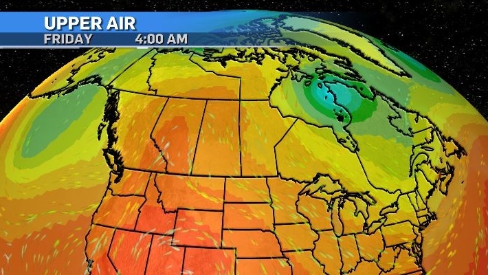
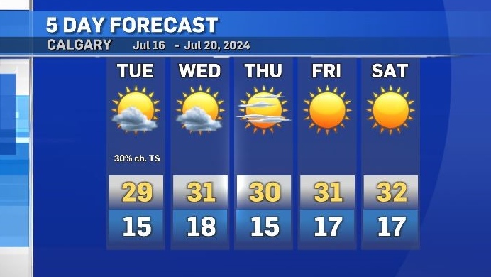
A blocking pattern will prevent normal flow in the upper levels, resulting in consistent sunshine after Thursday and elevated temperatures starting today.
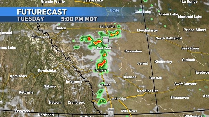
Tuesday and Wednesday will still include scattered cloud cover and the risk of late day showers and/or thunderstorms due to embedded shortwave troughs.
If thunderstorms do develop Tuesday, they will form along the foothills and pose the greatest risk along the QEII corridor with medium-sized hail, strong winds and the potential for supercells.
Later in the week, the atmosphere is expected to be so stable that clear skies will be uninterrupted.
This event is similar to the one in 2021 in its synoptic setup. A northerly riding, clockwise rotating high pressure system will be anchored at the base by two offsetting counter-clockwise rotating low pressure systems.
According to Environment and Climate Change Canada (ECCC), “For the next eight to 10 days, daytime highs will be between 28 and 36 degrees Celsius and overnight lows will range from 12 to 20 degrees Celsius.”
It is imperative to stay hydrated and find ways to cool off when dealing with prolonged periods of extreme heat.
In their warning, ECCC advises certain people are particularly vulnerable.
“Pay particular attention to individuals that can experience earlier or more severe effects from heat including infants, children, seniors, and individuals with pre-existing lung, heart, kidney, nervous system, mental health or diabetic conditions, outdoor workers, as well as those who are socially isolated.”
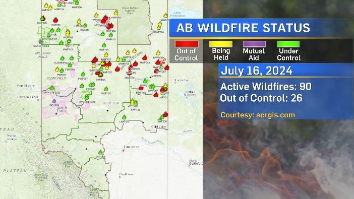
This heat is likely to amplify the wildfire risk across Alberta and B.C.
As of 7:30 a.m., Tuesday the province was reporting 90 active wildfires in Alberta, with 26 of those fires burning out of control.
There is a triangle of criteria considered for heightened wildfire risk, including seven to 10 days of hot, dry weather, a fuel source and ignition (e.g. human-caused or lightning).
As of 7 a.m., Tuesday, the wildfire relative danger index was showing an increased area of amplified risk, a situation that will only get worse over the next few days.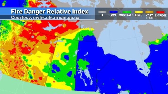
In Calgary, daytime highs are expected to range from 29 C to 33 C with overnight lows of 15 C to 18 C.
The average range is 23 C and 10 C respectively.


CTVNews.ca Top Stories

'Bank investigator' fraud spreading in eastern Ontario: What it is and how to avoid it
Ontario Provincial Police and the Canadian Anti-Fraud Centre are warning people about fraudsters impersonating major Canadian banks.
Commercial truck plunges off bridge in B.C. Interior, driver unaccounted for, RCMP say
The driver of a semi truck and trailer that plunged off of a bridge in the B.C. Interior Saturday morning has not been located, according to police.
German police make second arrest over stabbing attack, IS claims responsibility
Police made a second arrest on Saturday in their investigation of a deadly stabbing in the western German city of Solingen, a spokesperson said. The Islamic State group has also claimed responsibility for the Saturday knife attack that killed three people and wounded eight others.
Chappell Roan's comments about invasive fans show that we never really know our favourite celebrities
Sudden fame has weighed heavy on Chappell Roan, but her discomfort became untenable earlier this week. She shared two videos on TikTok in which she criticized invasive fans who have followed her around, 'stalked' her family and demanded photos or hugs in public despite Roan's resistance.
Brother-in-law of man allegedly swarmed by teens says family reeling from loss
The brother-in-law of a homeless Toronto man who died after police allege he was attacked by a group of teen girls says his entire family is reeling from the loss.
Tugboats free grounded cargo ship blocking traffic in St. Lawrence Seaway
A stuck 138-metre cargo ship that had been blocking traffic in the St. Lawrence Seaway near Montreal has been freed.
'We have won': Kenyan man granted temporary residency day before deportation order
One day before he was set to be deported to Kenya, Charles Mwangi was granted temporary residency.
A rare but deadly mosquito virus infection has Massachusetts towns urging vigilance
A rare but deadly disease spread by mosquitoes has one town in Massachusetts closing its parks and fields each evening. Four other towns are urging people to avoid going outdoors at night.
Shohei Ohtani is baseball's fastest 40-40 man and has time to become the first member of 50-50 club
Japanese superstar Shohei Ohtani hit a two-out grand slam in the ninth inning for his 40th homer after earlier stealing his 40th base, lifting the Los Angeles Dodgers to a 7-3 win over the Tampa Bay Rays on Friday night. He is the sixth player ever to reach 40 homers and 40 stolen bases in a season.
Shopping Trends
The Shopping Trends team is independent of the journalists at CTV News. We may earn a commission when you use our links to shop. Read about us.


Edmonton
-

Blackfalds mother hits dead end after daughter's busing application rejected
A mother in Blackfalds, Alta. has to find a new way to get her nine-year-old daughter to school after guidelines set by the province made her ineligible for busing.
-
RCMP find 'extremely dangerous' suspect in stabbing near Westlock
RCMP in Westlock arrested a man suspected in a stabbing that prompted an Alberta Emergency Alert Friday night.
-
Major Canadian rental company warns tenants that hackers may have their banking info
One of western Canada’s largest rental property companies is warning tenants about a cyber security breach it says was discovered earlier this year.
Lethbridge
-

Pro Power Wrestling returns to Whoop-Up Days for a bare-knuckle brawl
Live wrestling is returning to Whoop-Up days Saturday night
-
Flapjacks flying this weekend in Lethbridge as Whoop-Up Days winds up
There’s only a few more chances to get your fill of pancakes at this year’s Whoop-Up Days.
-
'Bigger every year': 2024 Lethbridge and District Pro Rodeo underway
The 2024 Lethbridge and District Pro Rodeo got underway Thursday evening, featuring the top competitors from across Canada.
Vancouver
-

Commercial truck plunges off bridge in B.C. Interior, driver unaccounted for, RCMP say
The driver of a semi truck and trailer that plunged off of a bridge in the B.C. Interior Saturday morning has not been located, according to police.
-
Fire destroys historic restaurant in Revelstoke, B.C.
No one was injured, but a historic restaurant was destroyed when a huge fire broke out at a motel site in Revelstoke, B.C., just after midnight Saturday.
-
Watchdog clears police of criminal offences in handling of Lumby, B.C., death
British Columbia's police watchdog group has closed its investigation of a woman's death in April in Lumby, B.C., saying it did not find any evidence of a criminal offence in officers' handling of the case.
Vancouver Island
-

Watchdog clears police of criminal offences in handling of Lumby, B.C., death
British Columbia's police watchdog group has closed its investigation of a woman's death in April in Lumby, B.C., saying it did not find any evidence of a criminal offence in officers' handling of the case.
-
BC NDP maintains lead, though new poll highlights concerns
Ahead of October’s provincial vote, a new poll commissioned by the B.C. Chamber of Commerce indicates the BC NDP enjoys a lead among decided voters, but the survey also highlights a number of concerns for the governing party.
-
B.C. auditor general cites two 'significant errors' in government's final accounts
The office of British Columbia's auditor general says he found two "significant errors" in the New Democrat government's year-end public financial statements, but the Ministry of Finance says it's been advised to continue using what it says are long-standing accounting practices.
Saskatoon
-

Major Canadian rental company warns tenants that hackers may have their banking info
One of western Canada’s largest rental property companies is warning tenants about a cyber security breach it says was discovered earlier this year.
-
Saskatoon hit by overnight flooding, traffic disrupted
Overnight storms and intense rainfall brought flooding to several areas of Saskatoon, causing traffic disruptions.
-
Three injured after vehicle crashes into Saskatoon house
Three people were sent to hospital after a single vehicle crashed into a house in Saskatoon Saturday morning.
Regina
-

Police launch investigation after woman found dead in Regina home
Police have launched an investigation after a woman was found dead in a Regina home on Friday night.
-
How do Saskatchewan's smoke hours this summer compare to last summer?
As wildfires continue to burn in the north, several parts of the province were placed under an air quality advisory on Friday.
-
'Big smiles and a lot of nostalgia': Pop icon Paula Abdul's tour set to stop by Regina and Saskatoon
Pop music sensation Paula Abdul is set to bring her energy to Saskatchewan this fall as part of her 'Straight Up! To Canada tour'.
Toronto
-

'We have won': Kenyan man granted temporary residency day before deportation order
One day before he was set to be deported to Kenya, Charles Mwangi was granted temporary residency.
-
Search continues for man wanted for murder in deaths of two female relatives in Etobicoke
Toronto police continue to look for a 33-year-old man wanted for murder in connection with the deaths of his two female relatives.
-
Many deaths predicted from Ontario's plan to shut supervised consumption sites: experts, data
The Ontario government's proposal to close supervised drug consumption sites may affect more facilities than initially expected, hitting programs that attend to thousands of potentially deadly overdoses a year, as lawyers doubt whether the move is constitutional.
Montreal
-

Start applying for English eligibility certificates sooner rather than later: EMSB
With the start of the new school year quickly approaching, many are wondering about the eligibility certificate and whether their family needs one. The answer is simple: if you want to enrol your child in an English elementary or high school in Quebec, they will need one.
-
Tugboats free grounded cargo ship blocking traffic in St. Lawrence Seaway
A stuck 138-metre cargo ship that had been blocking traffic in the St. Lawrence Seaway near Montreal has been freed.
-
Dozens of baby turtles set free in Quebec river as part of zoo conservation project
Dozens of endangered baby spiny softshell turtles are being released into a southern Quebec river today as part of a project to help save the species.
Atlantic
-

Halifax streets and rotary closed until Monday
Halifax Water advised Thursday that it would close portions of Chebucto Road and Armdale Rotary from Friday at 6:00 p.m. through Monday at 6:00 a.m.
-
Premier Higgs 'strongly objects' to naming of nurses in Horizon Health lawsuit
New Brunswick Premier Blaine Higgs has issued a statement strongly objecting to legal tactics that personally name health-care professionals in lawsuits.
-
'I don't want to move': N.B. residents concerned by covered bridge closures
The Midway/Germantown Covered Bridge may not be the longest covered bridge in New Brunswick, but its closure is a big deal to Hilyard and Sylvia Rossiter.
Winnipeg
-

Manitoba staple snacks marking milestone anniversaries
Two Manitoban snacking staples – Old Dutch Ltd. and Mordens’ are celebrating a combined 135 years in business in Winnipeg.
-
6 people evacuated from house fire in Winnipeg’s Spence neighbourhood
Six people were evacuated from a home in Winnipeg’s Spence neighbourhood after a fire in the 600 block of Furby Street.
-
Broken elevator leaves Steinbach residents ‘trapped’ in suites
Some tenants in an affordable housing building in Steinbach, Man., are having trouble accessing their suites because of a broken elevator.
Ottawa
-

Two tornadoes confirmed during storms southeast of Ottawa Wednesday
Scientists with Western University's Northern Tornadoes Project (NTP) confirm two tornadoes touched down in eastern Ontario towns on Wednesday, with one causing some minor damage.
-
Human remains found after house fire west of Renfrew
The remains of one person were found after a house fire west of the Town of Renfrew early Friday morning.
-
What's happening in Ottawa this weekend: Aug. 23-25
The Ottawa Redblacks take the field at TD Place, fair season continues in eastern Ontario, it's the final weekend for Ottawa Greek Festival and see Come from Away and Cirque du Soleil. CTVNewsOttawa.ca looks at things to do in Ottawa this weekend.
Northern Ontario
-
'Bank investigator' fraud spreading in eastern Ontario: What it is and how to avoid it
Ontario Provincial Police and the Canadian Anti-Fraud Centre are warning people about fraudsters impersonating major Canadian banks.
-
Surge in stabbings in Sudbury linked to personal disputes, drugs and alcohol
There has been a sudden increase in stabbing attacks in Greater Sudbury in recent days.
-
Hwy. 17 reopens after crash near Espanola
The Ministry of Transportation's 511 Traveller Information Service says Highway 17 has reopened after being closed Saturday afternoon due to a collision.
Barrie
-

Big crowds turn out for annual Rama First Nation Powwow
In celebration of culture and community, an annual powwow drew thousands to the Rama First Nation this weekend.
-
Police search for suspect in early morning robbery investigation
Investigators have released images of a suspect connected to an early morning robbery in Gravenhurst.
-
Pedestrian struck in fail-to-remain overnight crash
Police are investigating an overnight fail-to-remain collision after a pedestrian was struck in Midland.
Kitchener
-

Waterloo Region embraces inaugural Caribana Ignite street party
For the first time in its 50-year history, Caribana made its way outside of Toronto, and the Kitchener community welcomed it with open arms.
-
Body found in Ont. identified as B.C. woman who went missing 19 years ago
A body discovered in a wooded area near Rockwood, Ont. has finally been identified as a missing British Columbia woman.
-
Neighbours disgusted by Nazi flag at Kitchener, Ont. home
Residents living in a Kitchener, Ont. neighbourhood are speaking out about a Nazi flag that was seen flying outside a home on their street.
London
-

London Brewery packed as Home County Music Festival returns for one-day event
It may not exactly look the same, but the Home County Music and Art Festival (HCMAF) is back.
-
Chatham-Kent Crime Stoppers to hold free fingerprint and car seat clinic in September
Parents are invited to solve some safety anxiety next month.
-
‘Filling a truck with menstrual products’: Collection happening at Wortley on the Green Saturday
A London charity has a goal of filling an entire U-Haul truck with menstrual products Saturday afternoon.
Windsor
-

Young drivers share innovative ideas to combat distracted driving at road safety event
With distracted driving posing a serious threat to the safety of both motorists and pedestrians, young drivers are sharing their ideas on how to reduce road collisions and fatalities related to it.
-
Chatham-Kent Crime Stoppers to hold free fingerprint and car seat clinic in September
Parents are invited to solve some safety anxiety next month.
-
Arrest made after alleged knife pull in theft and assault investigation: Police
The Chatham-Kent Police Service (CKPS) has arrested a 49-year-old Wallaceburg man following an incident at a local business.


