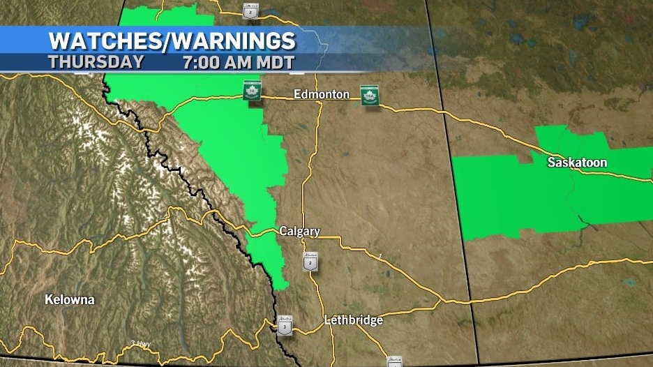
Rainfall warnings west of Calgary, and severe thunderstorms likely
As expected a slow-moving low pressure system moving in to Alberta from southern B.C. has prompted Environment and Climate Change Canada (ECCC) to expand rainfall warnings first issued on Wednesday.
Areas along the foothills – including Kananaskis and Canmore, are now included under this advisory.
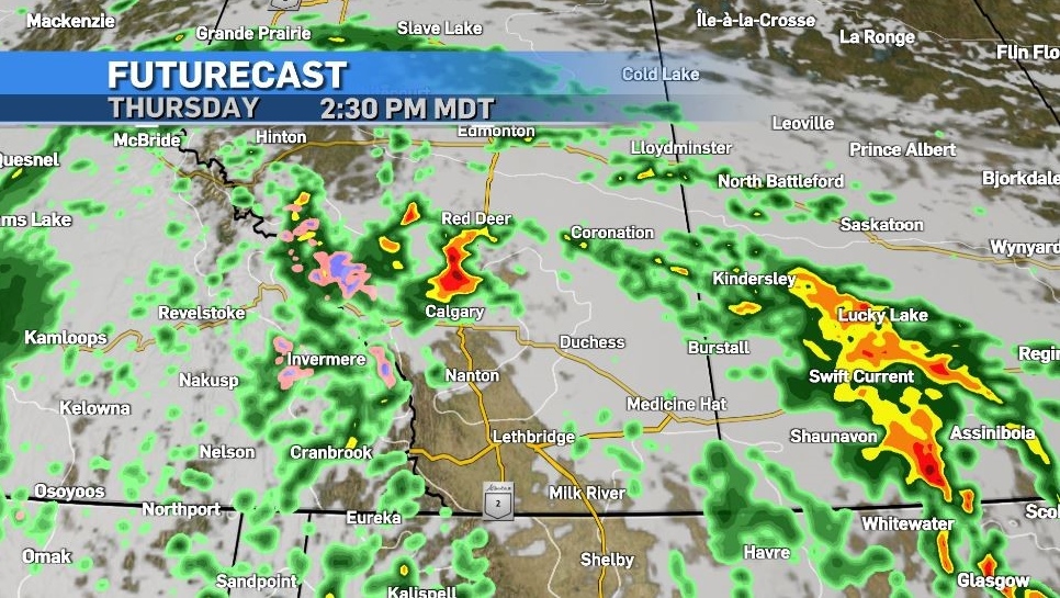
“Heavy rain will begin today, with total amounts of 50 to 80 milimetres (expected)," ECCC said.
The weather agency also notes “areas in the foothills will see heavy rain and embedded thunderstorms begin by Thursday afternoon and intensify through the evening hours.”
Strong winds will precede this system, and convective activity is expected to last for a good portion of the day in affected areas, including Calgary.
Daytime heating is often a key element aiding in the development of severe thunderstorm, and if there is a window for surface heating to occur today that will enhance storm energy.
But mechanical lift can also serve to assist in storm development – and that is the more likely scenario for Thursday in southern Alberta.
As of 7 a.m. Thursday, the only advisories that had been issued from ECCC were rainfall warnings – but it would be reasonable to expect to see severe thunderstorm watches or warnings as the day continues.
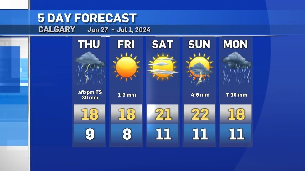
This low is going to remain slow-moving on the Alberta side of the Rockies, so areas that are caught under it will likely have significant rainfall totals including Calgary, with around 30 milimetres expected.
Sunshine will make a brief return Friday afternoon and Saturday. Rain is likely on Sunday and Monday for Canada Day celebrations.
Shopping Trends
The Shopping Trends team is independent of the journalists at CTV News. We may earn a commission when you use our links to shop. Read about us.


CTVNews.ca Top Stories

Trudeau appears unwilling to expand proposed rebate, despite pressure to include seniors
Prime Minister Justin Trudeau does not appear willing to budge on his plan to send a $250 rebate to 'hardworking Canadians,' despite pressure from the opposition to give the money to seniors and people who are not able to work.
'Mayday!': New details emerge after Boeing plane makes emergency landing at Mirabel airport
New details suggest that there were communication issues between the pilots of a charter flight and the control tower at Montreal's Mirabel airport when a Boeing 737 made an emergency landing on Wednesday.
Cucumbers sold in Ontario, other provinces recalled over possible salmonella contamination
A U.S. company is recalling cucumbers sold in Ontario and other Canadian provinces due to possible salmonella contamination.
Latest updates: Tracking RSV, influenza, COVID-19 in Canada
As the country heads into the worst time of year for respiratory infections, the Canadian respiratory virus surveillance report tracks how prevalent certain viruses are each week and how the trends are changing week to week.
Weekend weather: Parts of Canada could see up to 50 centimetres of snow, wind chills of -40
Winter is less than a month away, but parts of Canada are already projected to see winter-like weather.
Atlantic hurricane season comes to an end, leaving widespread damage in its wake in U.S.
The 2024 Atlantic hurricane season comes to a close Saturday, bringing to an end a season that saw 11 hurricanes compared to the average seven.
Armed men in speedboats make off with women and children when a migrants' dinghy deflates off Libya
Armed men in two speedboats took off with women and children after a rubber dinghy carrying some 112 migrants seeking to cross the Mediterranean Sea started deflating off Libya's coast, a humanitarian aid group said Friday.
Federal government posts $13B deficit in first half of the fiscal year
The Finance Department says the federal deficit was $13 billion between April and September.
W5 Investigates
W5 Investigates A 'ticking time bomb': Inside Syria's toughest prison holding accused high-ranking ISIS members
In the last of a three-part investigation, W5's Avery Haines was given rare access to a Syrian prison, where thousands of accused high-ranking ISIS members are being held.
Edmonton
-

Pedestrian hospitalized after Friday morning crash in central Edmonton
A woman is in hospital with serious injuries after a crash on Friday morning.
-
Trudeau appears unwilling to expand proposed rebate, despite pressure to include seniors
Prime Minister Justin Trudeau does not appear willing to budge on his plan to send a $250 rebate to 'hardworking Canadians,' despite pressure from the opposition to give the money to seniors and people who are not able to work.
-
'Fear and shame': Red Deer police issues warning of rising online sextortion incidents
Red Deer RCMP issued a warning to the public about the increase of sextortion incidents online.
Lethbridge
-

Lethbridge Hurricanes name 3 new members to its Wall of Honour
The Lethbridge Hurricanes’ Wall of Honour will be getting a little more crowded.
-
Avonlea Homes team members go on shopping spree for Lethbridge Family Services' Angel Tree Campaign
The Christmas spirit was on full display Thursday morning inside Toys "R" Us thanks to the team from Avonlea Homes, who spent their morning buying toys and gifts for Lethbridge Family Services’ Angel Tree Campaign.
-
Marshal Iwaasa's family still seeks answers five years after his disappearance
On Nov. 17, 2019, 26-year-old Marshal Iwaasa left his mother's home in Lethbridge and told his family he was driving to Calgary.
Vancouver
-

Study of 2023 Okanagan wildfires recommends limiting development in high-risk areas
A study into the devastating wildfires that struck British Columbia's Okanagan region in 2023 has recommended that government and industry limit development in high-fire-risk areas.
-
Man facing 10 charges after Richmond, B.C., crime spree
A Metro Vancouver man has been charged with nine counts of breaking and entering and one count of mischief after a five-day crime spree last November.
-
Vancouver Canucks defenceman Hronek being evaluated for undisclosed injury
Vancouver Canucks defenceman Filip Hronek has been sidelined by an undisclosed injury.
Vancouver Island
-

Winter storm watch issued as snow, heavy rain expected for B.C. coast
A winter storm is moving over British Columbia's coast, bringing strong winds, heavy snow and freezing rain as snowfall warnings continue for much of the province's Interior.
-
Police renew appeal for information 12 years after Victoria woman's disappearance
On the anniversary of her disappearance, police in Victoria renewed their appeal for information in Emma Fillipoff’s 12-year-old missing persons case.
-
Man facing 10 charges after Richmond, B.C., crime spree
A Metro Vancouver man has been charged with nine counts of breaking and entering and one count of mischief after a five-day crime spree last November.
Saskatoon
-

'Due to the temperatures, we are concerned': RCMP seek tips finding missing elderly man
Saskatchewan RCMP are asking property owners in the rural area in the RM of Laird to check farm outbuildings or sheds in their area for a missing 60-year-old man.
-
Ontario men arrested after Saskatoon police seize 16 kilos of meth, nearly $70K in cash
Saskatoon police say officers arrested three 20-year-old men Wednesday afternoon and seized nearly $70,000, in cash as well as various illicit drugs.
-
'Came back hungry': Mustangs atop SJHL standings after falling short in National Championship last season
The Melfort Mustangs are sitting atop the Saskatchewan Junior Hockey League (SJHL) standings after falling short in the Centennial Cup last season.
Regina
-

Here's how thick ice needs to be to park a truck on it, according to Sask. Water Security Agency
The Saskatchewan Water Security Agency (WSA) says ice should be at least one foot (30 centimetres) thick before it's safe to drive a car or light truck on a frozen body of water.
-
Fundraising campaign at Regina school ends with an alpaca kiss
Students, staff and family members of Imperial Community School gathered to celebrate a successful fundraising campaign for United Way Regina.
-
'Came back hungry': Mustangs atop SJHL standings after falling short in National Championship last season
The Melfort Mustangs are sitting atop the Saskatchewan Junior Hockey League (SJHL) standings after falling short in the Centennial Cup last season.
Toronto
-
 BREAKING
BREAKING Feds announce $758 million in funding for new Line 2 TTC subway trains
The TTC will get funding from the federal government to replace aging trains on Line 2, Deputy Prime Minister Chrystia Freeland has announced.
-
Highway 407 owner says no active buyback discussions with Ontario government
The provincial government is facing increasing pressure to tap into the underused and tolled Highway 407 to alleviate congestion on Highway 401.
-
Cucumbers sold in Ontario, other provinces recalled over possible salmonella contamination
A U.S. company is recalling cucumbers sold in Ontario and other Canadian provinces due to possible salmonella contamination.
Montreal
-

Quebec trying to 'minimize' impact of health care cuts on services
Eliminating $1.5 billion in health care spending is likely to have an impact on services, but Quebec says it will try to 'minimize' it.
-
One woman killed, one hurt in armed robbery attempt southeast of Quebec City
One woman was killed and another was badly injured following an alleged armed robbery attempt at a clothing store southeast of Quebec City.
-
'Mayday!': New details emerge after Boeing plane makes emergency landing at Mirabel airport
New details suggest that there were communication issues between the pilots of a charter flight and the control tower at Montreal's Mirabel airport when a Boeing 737 made an emergency landing on Wednesday.
Atlantic
-

Prime Minister Trudeau adds $7.1 million to P.E.I. school food program
Prime Minister Justin Trudeau travelled to Prince Edward Island today where he announced $7.1 million over three years to support that province's school food program.
-
Some closures, power outages in the Maritimes with first storm of the winter season
Parts of the Maritimes are experiencing their first winter storm on Friday with a messy weather system moving north from the eastern U.S.
-
Suspect taken into custody after weapons complaint at Halifax high school
A suspect has been taken into custody after a high school in Halifax was placed in hold and secure Friday morning.
Winnipeg
-

IIU looking for witness of fatal officer-involved shooting
Manitoba's police watchdog is looking for a person they say witnessed an officer-involved shooting that killed one person.
-
Water main break causing Friday morning traffic delays in Winnipeg
Winnipeg drivers are being warned of traffic delays on Friday morning due to a water main break.
-
A tale of two downtowns: Restaurants opening and closing show complexity of downtown revival
Proposed developments and new businesses opening are fueling optimism for some on a revival of downtown Winnipeg, but some business owners say the present remains problematic.
Ottawa
-

Ottawa police charge two adults, teenager following Orleans kidnapping and robbery
The Ottawa Police Service says two adults and a teenager are facing multiple charges following a kidnapping, robbery and extortion incident that happened last month in Orleans.
-
'Dude, Where's My Bus?' Ottawa man fed up with OC Transpo makes documentary exploring transit troubles
Gio Petti put together a documentary on OC Transpo, asking how we got here. How did a city that was once lauded as an example of how to do transit right, and that boasted some of the highest per capita transit ridership numbers in the country, become a system that now elicits so much frustration from users?
-
Almonte business to deliver letters to Santa
As the Canada Post strike enters it's third week with no end in site, many Canadians are wondering if their Christmas wish lists will get to the North Pole this year.
Northern Ontario
-

Man fined $10K for abandoning homemade barge in Lake Nipissing
A man from Lavigne, Ont., has been fined $10,000 for abandoning a homemade barge in Lake Nipissing.
-
Another 60 cm of snow possible in the Sault as severe weather continues
Closures and cancellations are piling up in Sault Ste. Marie as a major winter storm continues for another day Friday.
-
California man who went missing for 25 years found after sister sees his picture in the news
It’s a Thanksgiving miracle for one California family after a man who went missing in 1999 was found 25 years later when his sister saw a photo of him in an online article, authorities said.
Barrie
-

50 cms of snow across central Ontario expected this weekend
Environment Canada has released snow squall warnings and watches for our region.
-
Alleged mastermind behind Ontario woman's presumed death seeks bail
The man facing first-degree murder and kidnapping charges in the disappearance of Ontario woman Elnaz Hajtamiri took another shot at bail on Friday in a Barrie courtroom. Mohamad Lilo, 37, has been behind bars since his arrest more than two years ago.
-
Two men charged with assaulting municipal law enforcement officer, one suspect at large
Two people face charges as police seek a third individual in connection with the alleged assault of a municipal law enforcement officer.
Kitchener
-

Erick Buhr to represent himself during sentencing for second-degree murder in death of his grandmother, Viola Erb
Erick Buhr will represent himself as he prepares for sentencing after being convicted of second-degree murder in the death of his grandmother, Viola Erb.
-
Man accused of involvement in massive data breach appears in Kitchener court
The man accused of being behind a massive data breach impacting several large U.S. companies made a brief appearance in Kitchener court Friday.
-
Police looking for missing teen last seen in Cambridge
Waterloo Regional Police are looking for information about the whereabouts of a missing teen.
London
-

Employees pepper sprayed at London business
Around 4 p.m. on Thursday, police were called to a report of an assault in progress at a business int he 600 block of Wilkins St. near Wellington Road.
-
Sarnia police lay charges after woman wakes up to naked man in her home
An arrest has been made after a break and enter call in Sarnia where a woman woke up to a naked man in her home. Police said after investigating, officers were able to identify a 26-year-old man who was also wanted on an outstanding warrant in London.
-
Knights' Boulton hit with eight-game suspension
The left winger has been suspended eight games, retroactive to Nov. 23 against Saginaw, when he was handed a major penalty for slashing, along with a game misconduct.
Windsor
-
 Breaking
Breaking Guilty on all counts: Windsor man convicted of careless driving in Retrofest double fatal collision
The Windsor man charged in connection to the double fatal Retrofest collision has been convicted on all counts.
-
$4,000 in products reported stolen from storage container
Chatham-Kent police are looking for suspects after $4,000 in products were stolen from a storage container in Chatham.
-
Potato Fest returns to raise money for charity
If you love the potato – then Potato Fest is a perfect event for you.


