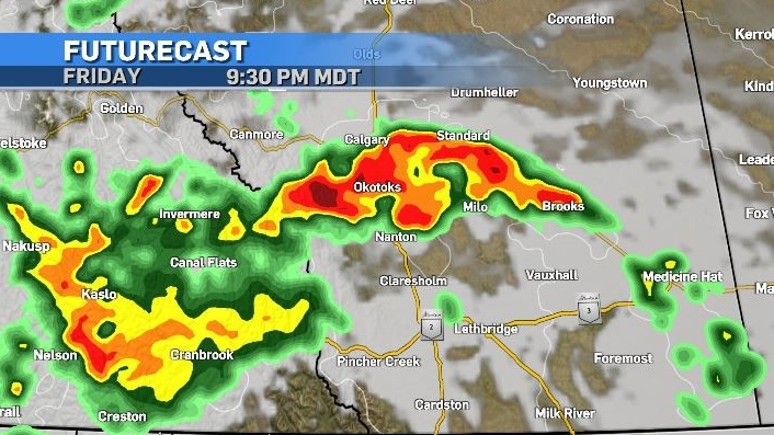
Severe thunderstorms possible Friday evening and early Saturday
A low pressure system along the Pacific coastline will be the main cause for concern in southern Alberta Friday night.
A shortwave trough in the exit region (the east side of the trough) will head straight into the southern border, where amble energy could aid in storm development.
Daytime highs in southern Alberta are forecast to reach the low 30s Friday, with the trough arrival coinciding with the end of the day when warmer air will be rising.
This increased water vapour in the atmosphere, combined with stronger and variable winds has the potential to create damaging thunderstorms. These storms are expected to be fast-moving with the greatest threats including heavy rain, medium to large-sized hail and damaging winds.
Calgary is likely to see some evening showers and thunderstorms with five to 10 millimetres of rain expected to fall.
As of 8 a.m. Friday Environment and Climate Change Canada had not issued any severe thunderstorm watches or warnings for the region – but this is likely to change.
The highest accumulations in Alberta will be closer to the foothills, with some areas in central Alberta potentially being impacted by a second round of rain as the low swings back around before heading east on Sunday.
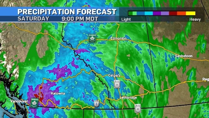
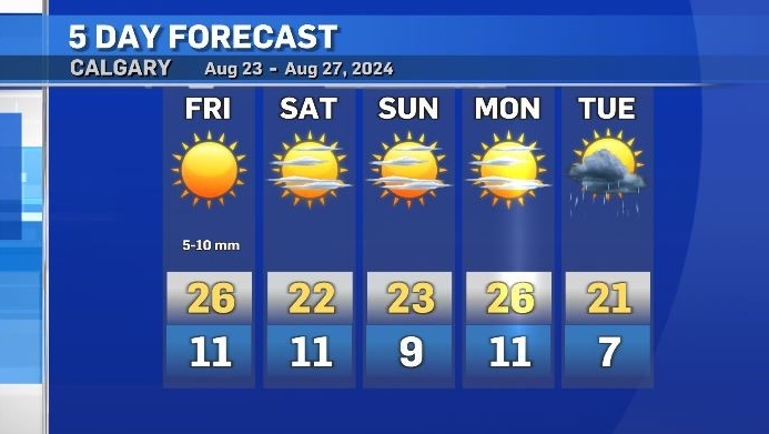
Calgary’s temperatures will return to seasonal on Saturday and Sunday before another system moves in on Tuesday.
The average daytime high for Calgary right now is 22 C with a low of 9 C.


CTVNews.ca Top Stories

BREAKING
BREAKING 2 dead, third in critical condition after attack in Kingston, Ont., suspect arrested
Two people are dead and a third suffered life-threatening injuries following an attack at an encampment in Kingston, Ont. Thursday. A suspect has been arrested following a multi-hour standoff.
TIFF pauses screenings of documentary about Russian soldiers due to 'significant threats'
The Toronto Film Festival says it has been forced to pause the screenings of a documentary about Russian soldiers this weekend, citing 'significant threats to festival operations and public safety.'
Trump rules out another debate against Harris as her campaign announces US$47M haul in hours afterward
Donald Trump on Thursday ruled out another presidential debate against Kamala Harris as her campaign announced a massive fundraising haul in the hours after the two candidates met on stage.
'Keep your bags packed': Consul general grilled over $9M NYC condo purchase
After weeks of pressure, Canada's consul general Tom Clark is testifying on Thursday before a House of Commons committee about the purchase of his new official residence in New York that generated a lot of political attention over the summer.
This Italian lawyer says he thought he was buying a regular print of Churchill, not the 'mythical' stolen portrait
When Nicola Cassinelli, Italian lawyer and occasional art collector, bid on a portrait of the late U.K. prime minister Winston Churchill, he says, he didn't know it would land him in the centre of an international criminal investigation.
Georgia judge dismisses two criminal counts against Trump, court filing shows
A Georgia judge on Thursday dismissed two criminal counts in the U.S. state's 2020 election interference case against Republican presidential candidate Donald Trump and one other count against allies of the former president.
Family of Sikh man speaks out against Toronto-area hospital after beard shaved
The family of a Sikh man from Brampton is seeking an apology, an explanation, and a promise to do better from the local hospital network after they say the facial hair of their loved one was removed without their consent.
NEW
NEW N.B. premier’s asylum seeker comments spark controversy
Claims from New Brunswick Premier Blaine Higgs that Ottawa wants to force the province to take in 4,600 asylum seekers are "largely fictitious," says federal Immigration Minister Marc Miller.
Ottawa resident who tested positive for mosquito-borne virus dies, public health says
An Ottawa resident who died of a viral encephalitis this summer tested positive for the mosquito-borne virus eastern equine encephalitis (EEEV), the first human case of the virus in Ottawa.
Shopping Trends
The Shopping Trends team is independent of the journalists at CTV News. We may earn a commission when you use our links to shop. Read about us.


Edmonton
-

Police investigating 'targeted' triple homicide in Lloydminster, Sask.
Police in Lloydminster have confirmed they are investigating a triple homicide in the border city.
-
Edmonton police seize more than $1.2M in street drugs after months-long investigation
The Edmonton Police Service says more than 66 kilograms of drugs have been seized in a large-scale drug investigation in central Edmonton that started in December.
-
Snacks, seating and super-fast charging: What to expect at Edmonton's new EV-only service station
Electric vehicle (EV) drivers in Edmonton now have a place to grab a snack and relax while they charge up.
Lethbridge
-

Taber RCMP warn of heavy police presence
Taber RCMP are instructing the public to avoid a section of the community due to a heavy police presence.
-
1 suspect in custody after break-in and violent assault of Lethbridge woman
A man is in police custody with charges pending in relation to a break-in and violent assault of a woman earlier this week.
-
Interfaith Food Bank puts out call for fresh vegetables, fruit and dairy as harvest season continues
As harvest season continues in southern Alberta, the Interfaith Food Bank in Lethbridge is putting out an urgent call for fresh food and produce.
Vancouver
-

B.C. signs national pharmacare deal with Ottawa, promises to expand drug coverage
British Columbia has become the first province in Canada to sign a pharmacare agreement with the federal government that would help the province fund hormone replacement therapy and diabetes expenses.
-
Night biking, queer films, and more events to check out in Metro Vancouver this weekend
There's lots going on in Metro Vancouver this weekend. Whether you're heading to Stanley Park for the Great Outdoors Comedy Festival or BC Place for Lions and Whitecaps home games, here are five other events worth checking out over the next few days.
-
Ceiling high for Vancouver Whitecaps midfielder Ahmed: Canada coach
Vancouver's Ali Ahmed started in both Canada's 2-1 victory over the United States on Saturday and Tuesday's 0-0 draw against Mexico.
Vancouver Island
-

Dry conditions mean increased wildfire risk in B.C. through the fall
An expert with the BC Wildfire Service says relentless drought conditions for much of British Columbia sets the stage for more fire activity this fall.
-
Realtor fined by B.C. regulator after property photos digitally altered
A British Columbia Realtor has been fined thousands of dollars after a property listing was found to contain photos that were digitally altered to hide peeling paint and show furnishings that did not exist.
-
B.C. family doctors press parties for plans to address crisis ahead of election
More than 700,000 British Columbians don't have a family doctor and two physicians’ groups want to know how the province’s political parties plan to address the crisis.
Saskatoon
-

Saskatoon police ask board to green light 31 new positions after infusion of provincial cash
The Saskatoon Police Service (SPS) is asking its board to green light 31 new full-time positions, after the province committed to permanently fund a host of new officers last week.
-
Saskatoon Tribal Council shelter will face cuts after new proposed shelter opens: province
The proposed downtown location for the city’s newest homeless shelter is drawing criticism from the chief of the Saskatoon Tribal Council (STC), which runs the city’s largest emergency shelter.
-
Saskatoon police investigating death following garage fire
Saskatoon Police Service (SPS) is investigating after a person was found dead following a fire early Thursday morning.
Regina
-

'Can be a real struggle': Veterinary shortage in Sask. particularly felt by exotic pet owners
As Saskatchewan is facing a shortage of veterinarians, owners of exotic pets are in a particularly tricky situation if their animal needs care.
-
Councillor Lori Bresciani to make 'major announcement' on upcoming election
Councillor Lori Bresciani will make a major announcement regarding her involvement in Regina's upcoming municipal election.
-
Sask. Entertainment Expo postponed to 2025 due to health concerns
This year’s edition of the Saskatchewan Entertainment Expo has been postponed until 2025.
Toronto
-

Chow says Toronto’s traffic congestion plan is working, acknowledges more could have been done sooner
Mayor Olivia Chow said Thursday that new data show Toronto’s congestion management plan is working to reduce gridlock, with recent travel times for drivers and transit riders showing improvement in some of the most congested parts of the downtown core.
-
TIFF pauses screenings of documentary about Russian soldiers due to 'significant threats'
The Toronto Film Festival says it has been forced to pause the screenings of a documentary about Russian soldiers this weekend, citing 'significant threats to festival operations and public safety.'
-
LifeLabs workers in GTA poised to strike if deal not reached by Saturday
LifeLabs workers in the Greater Toronto Area could soon walk off the job if a deal isn’t reached with their employer.
Montreal
-

Parents outraged after homeless man allegedly spits on a 3-year-old near daycare
Some parents in the Hochelaga-Maisonneuve borough are worried after a homeless man allegedly attacked a 3-year-old child while he was on his way to daycare located next to a homeless shelter.
-
Quebec MNA Youri Chassin leaves the CAQ ship
In another blow for the Coalition Avenir Québec (CAQ), Saint-Jérôme MNA Youri Chassin is leaving the party just hours after publishing an open letter criticizing his own government.
-
Quebec filmmaker Denis Villeneuve donates to Montreal indie Cinema du Parc
Quebec filmmaker Denis Villeneuve has given a major donation to the independent Montreal cinema - Cinema du Parc - he frequented as a young film student.
Atlantic
-
 NEW
NEWNEW N.B. premier’s asylum seeker comments spark controversy
Claims from New Brunswick Premier Blaine Higgs that Ottawa wants to force the province to take in 4,600 asylum seekers are "largely fictitious," says federal Immigration Minister Marc Miller.
-
Driver, 15, dies after crashing into power pole, tree in Stellarton, N.S.
A 15-year-old has died after a single-vehicle collision in Stellarton, N.S., early Thursday morning.
-
Tidal power junk: N.S. village wants huge, abandoned moorings moved from fishing area
Residents of a small Nova Scotia community are worried about who will remove four concrete-filled boxcars sitting in their harbour after a tidal power firm collapsed.
Winnipeg
-

Man charged after multiple child sex dolls seized from home: Winnipeg police
A Winnipeg man has been charged with multiple offences after sex dolls designed to look like children were seized from his home.
-
Three new options unveiled for new Manitoba health cards
Premier Wab Kinew posted on Instagram Thursday asking for opinions on three draft designs for the new health cards.
-
Appeal against drug treatment facility in Winnipeg neighbourhood defeated
The City of Winnipeg’s appeal committee has voted against an appeal from Linden Woods area residents who were pushing back on a proposed drug treatment facility.
Ottawa
-
BREAKING
BREAKING 2 dead, third in critical condition after attack in Kingston, Ont., suspect arrested
Two people are dead and a third suffered life-threatening injuries following an attack at an encampment in Kingston, Ont. Thursday. A suspect has been arrested following a multi-hour standoff.
-
Ottawa resident who tested positive for mosquito-borne virus dies, public health says
An Ottawa resident who died of a viral encephalitis this summer tested positive for the mosquito-borne virus eastern equine encephalitis (EEEV), the first human case of the virus in Ottawa.
-
'Buy Local': PSAC changes shopping message amid backlash for asking workers to boycott downtown Ottawa businesses
A federal public service union is now encouraging its members to "buy local" and support neighbourhood businesses, one day after a social media post suggested federal workers boycott downtown businesses in an apparent retaliation for the return-to-office mandate.
Northern Ontario
-

Greater Sudbury's encampment population has doubled in a year
More tents are going up in Energy Court at an encampment near the former safe consumption site trailer.
-
Trump rules out another debate against Harris as her campaign announces US$47M haul in hours afterward
Donald Trump on Thursday ruled out another presidential debate against Kamala Harris as her campaign announced a massive fundraising haul in the hours after the two candidates met on stage.
-
Public pooping leads to threats charge at northern Ont. campground
An incident involving siblings last weekend in Thessalon, Ont., ended with threats against campground staff and charges for one of the family members.
Barrie
-

Ont. police officer's spouse charged in historical sexual assault case involving a child
CTV News is learning more about disturbing allegations of sexual assault from 14 years ago in Beeton involving the husband of a Peel Regional police officer.
-
Guns & high capacity magazines seized, teens arrested after threats against Collingwood, Ont. school
Ontario Provincial Police (OPP) officers investigating a threat made against a Simcoe County school arrested two young men and seized several weapons.
-
Fully loaded gun seized during Barrie traffic stop: BPS
A man and a woman face several drug and weapons-related offences after police say they seized a fully loaded handgun during a traffic stop in Barrie.
Kitchener
-

Early apple harvest for farmers in Region of Waterloo
Apple trees are already being harvested at the Martin's Family Fruit Farm in Waterloo, Ont., at least one week ahead of their typical schedule.
-
Waterloo, Ont. man with stage 4 cancer qualifies for Boston Marathon
A Waterloo, Ont. man diagnosed with a rare and aggressive form of cancer continues to beat all odds.
-
More kids facing food insecurity than ever before, say experts
Local organizations say the number of kids experiencing food insecurity has risen in Waterloo Region.
London
-

TVDSB releases expenses for off-site retreat to Toronto
More details have been released on the expenses associated with TVDSB's off-site planning meeting in Toronto.
-
Pedestrian fighting for life in hospital after overnight crash near Western
A pedestrian is in hospital with life-threatening injuries after a violent two car crash near the Western University gates on Richmond Street north early Thursday morning.
-
Survivor winner training to become a doctor in London, Ont.
A Canadian winner of the reality series Survivor is spending part of her $1 million U.S. paycheck to train to become a doctor in London, Ont.
Windsor
-

Crash between car and tractor trailer kills two people
Around 1 p.m. on Wednesday, OPP, fire and EMS responded to a crash between a tractor trailer and a passenger vehicle, at the intersection of Inwood Road and Courtright Line in Brooke-Alvinston.
-
Could a Windsor resident win the record Lotto Max jackpot? Here are the odds:
Some Windsor lotto players are likely hoping for a historic $75 million win this Friday.
-
Memorial left at site of shooting victim in Windsor
A small memorial has been left at the site of a deadly police-involved shooting in the city core last week. Jason west died at the corner of Elliott Street east and Goyeau Street, after being shot by police.


