Storm potential in Calgary overnight
AFTERNOON UPDATE: We're still watching. For now, that's all we've got, is watching. However, events are beginning to unfold:
Locally, Calgary remains out of this web - that's not to say these circumstances will last forever. Hail is possible locally, with potential it reaches dime-sized pieces, and a smaller chance it's larger in isolated areas. The expectation is that a blast of cool air is going to pelt our temperature down, increase our wind, lift the warm, moist air mass near the surface, and generate storms.
The read-outs keep this now from 2-4 p.m.
The rest of the week remains benign - we've got another chance of showers - and a possible thundershower, though the chance at present is remote in this case - Wednesday.
MORNING EDITION: Well that went okay yesterday for farmers! We'll still be running a precipitation deficit for a while, yet, but with 10.9 millimetres of rain recorded at the airport, that was by far the wettest day Calgary has had so far, corroborated with this from around 10:00 a.m. Sunday.
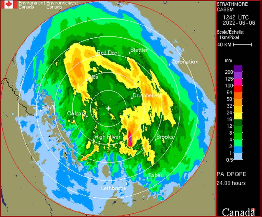
While the Calgary data is quite simple to come across, other locations are not as easy to track – still, here's a look from the Strathmore radar at the 24-hour precipitation accumulation from 6:42 a.m., Sunday to Monday:

You're seeing that right; to Calgary’s southeast, between Lomond and Armada, Alta., there was well in excess of 100 millimetres of rain, as severe weather parked stationary over the region for at least five hours. This created localized flooding, with the dry ground unable to drink in the moisture fast enough.
More is on the way. In part due to yesterday's rain, some events will be severe thunderstorms.
The risk zone for significant weather runs in a band from Grande Prairie down through Lethbridge and Medicine Hat, parallel to the foothills. This includes a good chance for Calgary. Therein, heavy rain bands will couple with (up to) quarter-sized hail and the possibility of funnel clouds.
Local rain totals will exceed five millimetres, may exceed 10 mm, and could go as high as 15 mm, especially with the trigger of a storm. The major factor for your consideration today: while these storms are still possible in the later afternoon, their best chance of forming is the early afternoon. There is even potential before we've crested past noon.
When thunder roars, head indoors. The afternoon update of this article will come a touch earlier, today.
Showers will persist tomorrow, lighter than the offering expected today. The remainder of the week clears up.
YOUR FIVE-DAY CALGARY FORECAST
Monday
- Evening: showers, low 9 C
Tuesday
- Showers, then afternoon clearing
- Daytime high: 16 C
- Evening: some cloud, low 8 C
Wednesday
- Partly cloudy, chance of afternoon showers
- Daytime high: 18 C
- Evening: clear, low 6 C
Thursday
- Mainly sunny
- Daytime high: 21 C
- Evening: mainly cloudy, low 13 C
Friday
- Mainly cloudy
- Daytime high: 22 C
- Evening: mainly cloudy, low 13 C
Saturday
- Partly cloudy
- Daytime high: 24 C
- Evening: some cloud, low 11 C
In the wake of severe storms, if it's safe to do so, please share those pictures my way on Twitter, or to our Instagram at @CTVCalgaryWeather.
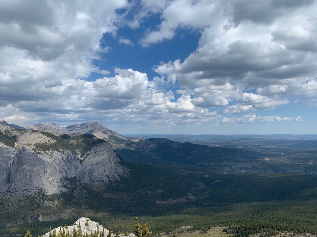
Today's pic was delivered by Don at Yamnuska, and it's a thing of beauty!
 Viewer Don's photo from Yamnuska.
Submit your weather photos here to see them featured in our article, and perhaps even as the pic of the day during our News at Six!
CTVNews.ca Top Stories

DEVELOPING Motive unclear as New York police hunt for masked killer who shot health insurance CEO
Investigators are searching for clues that could help them identify the masked gunman who killed the leader of one of the largest U.S. health insurance companies on a Manhattan sidewalk, then disappeared into Central Park.
DEVELOPING School bus cancellations in parts of Canada due to wintry weather
School buses are cancelled in parts of Canada Thursday as wintry weather moves in during the first week of December.
NEW AI modelling predicts these foods will be hit hardest by inflation next year
The new year won’t bring a resolution to rising food costs, according to a new report that predicts prices to rise as much as five per cent in 2025.
'Name what things are': Recognizing 'femicide' 35 years after the Montreal massacre
Ahead of the 35th anniversary of the Montreal Massacre, Annie Ross, a mechanical engineering professor at Polytechnique Montreal, said she often thinks of those who lived through the tragedy but still suffer silently.
Canada Post stores continue to operate during strike — but why?
As many postal workers continue to strike across the country, some Canadians have been puzzled by the fact some Canada Post offices and retail outlets remain open.
Toddler fatally shot after his 7-year-old brother finds a gun in the family's truck
A two-year-old boy was fatally shot when his seven-year-old brother found a gun in the glovebox of the family's truck in Southern California, authorities said.
Mother sues Mattel over 'Wicked' dolls linked to adult film website
Mattel was sued this week by a South Carolina mother for mistakenly putting a link to an adult film site on the packaging for its dolls tied to the movie 'Wicked.'
NEW Health Canada recalls more than 300 sexual enhancement products in four provinces
Health Canada has recalled hundreds of different sexual enhancements products from stores in Ontario, Quebec, Alberta and B.C.
Federal minister Harjit Sajjan to attend Taylor Swift concert with taxpayer-funded ticket
Harjit Sajjan, the federal minister responsible for the Pacific Economic Development Agency of Canada, will be going to the Eras Tour on taxpayer dollars.


