Stabbing at Calgary Value Village under investigation by police
Calgary police took two people into custody on Friday after a stabbing in the community of Haysboro.
Unable to retrieve weather data
Calgary police took two people into custody on Friday after a stabbing in the community of Haysboro.

If you've spent any amount of time scrolling TikTok at 3 a.m. (it's OK -- we all have), you probably know the meme...

It will warm up tomorrow, but it will also be gusty at times.
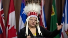
An Alberta political scientist said the NDP leadership hopefuls remained fairly even following the first of the party’s debates.
Four people have been charged with second-degree murder in relation to the 2020 death of a man in Innisfail, Alta.
Former Calgary mayor and current NDP leadership candidate Naheed Nenshi says the Alberta government is operating out of spite with new legislation that would grant it sweeping powers over municipalities, including the right to fire councillors, overturn bylaws and postpone elections.
A Calgary man has been sentenced to 30 months in prison for his role in a downtown stabbing spree last year that sent multiple people to hospital.
A boil water advisory has been lifted for residences supplied by Salt Box Coulee Waterworks System in Rocky View County.
Canada's largest cosplay parade is back in full force, returning to city for the 10th time on Friday.
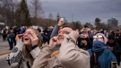
More than 115 people who viewed the solar eclipse in Ontario earlier this month experienced eye damage after the event, according to eye doctors in the province.
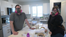
A Sherwood Park family says their new house is uninhabitable. The McNaughton's say they were forced to leave the house after living there for only a week because contaminants inside made it difficult to breathe.
A man has been handed a lengthy hunting ban and fined thousands of dollars for illegally killing a grizzly bear, B.C. conservation officers say.
The B.C. NDP has asked the federal government to recriminalize public drug use, marking a major shift in the province's approach to addressing the deadly overdose crisis.
The Ontario Provincial Police (OPP) says it's investigating an interaction between a uniformed officer and anti-Trudeau government protestors after a video circulated on social media.
Students at a Que. school are accusing their teacher of unlawfully selling their art online. Genevieve Beauchemin has the details.
Killer whale calf swims out of a B.C. lagoon where it has been trapped for a month after several rescue attempts. Yvonne Raymond reports.