Another pattern flip will push Calgary's weekend temps to the mid-20s
After a cold, wet and windy start to the week, the weekend promises a totally different weather story.
All warnings were lifted for Calgary by Wednesday morning, although rainfall warnings and snowfall warnings remained in place for southern Alberta as the final remnants of a strong low pressure system south of the border continues to impact the region.
That low is the southwest anchor of an Omega Block – weather patterns which are often responsible for persistent conditions due to their tendency to “stall out” as the southern lows and northern high hold each other in place.
This upper level pattern is breaking down, in part because of an incoming high pressure system moving in from the Pacific Northwest. That ridge will draw warmer air into B.C. and Alberta – and elevate temperatures well-above seasonal.
Some locations in southern British Columbia will see daytime highs over the weekend in the high 20s, and possibly 30 C, which would be the first 30 C temperature in Canada for 2024.
In southern Alberta this stable weather is expected to last for a few days. Conditions will be mostly sunny and daytime highs should easily reach the mid to high 20s for Friday, Saturday and Sunday.
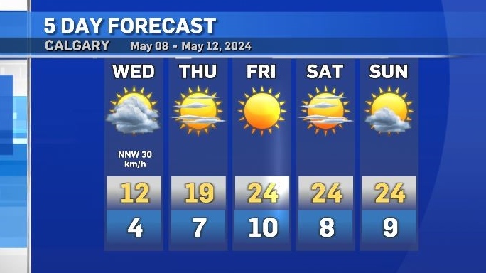
Light and scattered rain is possible in Calgary starting Monday, and temperatures will start to drop closer to seasonal.
According to Environment and Climate Change Canada (ECCC), the 24-hour rainfall totals in many communities in southeastern Alberta (as of 4 p.m. Tuesday) exceeded 50 milimetres. ECCC reported 33 milimetres of rain in Medicine Hat and 31.9 milimetres in Brooks.

Wind warnings were issued across much of southern Alberta yesterday due to the potential for damaging winds.
According to ECCC, peak speeds for wind gusts included 106 km/h in Onefour, 102 km/h in Bassano, 94 km/h in Brooks and 89 km/h at the Calgary International Airport.


CTVNews.ca Top Stories

Iran President Ebrahim Raisi still missing after helicopter accident in mountains
A helicopter carrying Iranian President Ebrahim Raisi, the country's foreign minister and other officials apparently crashed in the mountainous northwest reaches of Iran on Sunday, sparking a massive rescue operation in a fog-shrouded forest as the public was urged to pray.
What do we know so far about the mysterious crash of the helicopter carrying Iran's president?
The apparent crash of a helicopter carrying Iran's president and foreign minister on Sunday sent shock waves around the region.
'A horrible way to start the summer': 3 killed in serious boat crash on lake north of Kingston, Ont.
Three people were killed and five others were injured Saturday night following a boat crash on the Buck Bay area of Bobs Lake, north of Kingston, Ont., the Ontario Provincial Police (OPP) said.
Walmart, Costco refusing to sign grocery code of conduct 'untenable': industry minister
Industry Minister Francois-Philippe Champagne says it's 'untenable' for 'smaller players' like Walmart and Costco to delay signing on to the government- and industry-led grocery code of conduct, now that industry giant Loblaw has agreed to do so.
Ottawa driver who appeared to be racing another vehicle on Highway 416 facing charges
The Ontario Provincial Police (OPP) says an Ottawa driver is facing charges after being caught going 187 km/h on Highway 416.
Ex-partner charged with first-degree murder after 55-year-old woman killed in Montreal
Less than 24 hours after Montreal's 12th homicide investigation began, Montreal police confirmed that a 55-year-old woman's death in St. Michel is the island's 13th homicide. The woman's ex-spouse has been charged with first-degree murder.
VIDEO
VIDEO Born without front legs, this dog has been inspiring the world for 3 years: Dresden farm owner
A sanctuary dedicated to animals with disabilities is celebrating the third birthday of one of its most popular residents.
Canadian immigration asks medical worker fleeing Gaza if he treated Hamas fighters
Lawyers are questioning Canada’s approach to screening visa applications for people in Gaza with extended family in Canada after one applicant, a medical worker, was asked whether he had treated members of Hamas.
Diddy admits beating ex-girlfriend Cassie, says he's sorry, calls his actions 'inexcusable'
Sean 'Diddy' Combs admitted Sunday that he beat his ex-girlfriend in a hotel hallway in 2016 after CNN released video of the attack, saying in a video apology he was 'truly sorry' and his actions were 'inexcusable.'
Shopping Trends
The Shopping Trends team is independent of the journalists at CTV News. We may earn a commission when you use our links to shop. Read about us.


Edmonton
-

McDavid expects 'great Game 7' after Oilers rebound against Canucks
A full-game effort by the Edmonton Oilers led to their 5-1 victory over the Canucks in Game 6 on Saturday to send the best-of-seven series to the limit, with the decisive showdown set for Monday in Vancouver.
-
RCMP warn of grandparent scams targeting Westlock, Morinville residents
RCMP are issuing a warning after a string of scams aimed at residents in Westlock and the surrounding area.
-
Flammable kids' sleepwear, salmonella-contaminated chips: Here are the recalls of this week
Health Canada and the Canadian Food Inspection Agency issued recalls for various items this week, including kids' bassinets, chips, and stoves. Here's what to watch out for.
Lethbridge
-

Buttazzoni overtime goal propels Bandits past Crusaders 4-3 in BCHL playoff
With just over two minutes remaining in the first overtime, Mirko Buttazzoni scored to give the Bandits a 4-3 victory over the Sherwood Park Crusaders Saturday in Brooks.
-
Brooks fall 4-3 to Crusaders in BCHL playoff game
The Sherwood Park Crusaders got some great goaltending from Erick Roest Friday night on the way to a 4-3 victory over the Brooks Bandits.
-
Lethbridge home prices continue to rise
The average home price in Lethbridge has jumped 11.6 per cent in the last year. A home in Lethbridge now costs just over $374,000 on average. That's according to the latest data from the Alberta Real Estate Association.
Vancouver
-
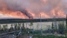
4 homes lost due to wildfire near Fort Nelson, B.C.
A wildfire burning near Fort Nelson, B.C., completely destroyed four homes, according to an update from the Northern Rockies Regional Municipality.
-
Employee information ‘compromised’ during London Drugs cyberattack, company says
Employee information may have been “compromised” during a cyberattack that shut down London Drugs stores across western Canada, according to the company.
-
Canucks must 'want that big moment' vs. Oilers in Game 7, coach says
All season long, the Vancouver Canucks have preached resilience. Now comes the ultimate test.
Vancouver Island
-
4 homes lost due to wildfire near Fort Nelson, B.C.
A wildfire burning near Fort Nelson, B.C., completely destroyed four homes, according to an update from the Northern Rockies Regional Municipality.
-
Employee information ‘compromised’ during London Drugs cyberattack, company says
Employee information may have been “compromised” during a cyberattack that shut down London Drugs stores across western Canada, according to the company.
-
Doctors, patients want options to reduce dialysis waste adding to climate change
Dr. Caroline Stigant, a nephrologist at Royal Jubilee Hospital in Victoria and a leading advocate for sustainable kidney care, said each hemodialysis treatment uses up to 500 litres of water and large amounts of energy.
Saskatoon
-

Saskatchewan Roughriders visit Saskatoon for Green and White day
Hundreds of Saskatoon's football fans gathered at Saskatoon Minor Football (SMF) field Saturday to experience the Saskatchewan Roughriders pre-season ahead of their home opener.
-
'The car was half inside my children's room': Car crashes into Saskatoon apartment building
Firefighters responded to a scene on the 300 Block of Herold Road Friday morning after a car collided with an apartment building.
-
Crews on scene of structure fire in Saskatoon
Firefighters are on the scene of a structure blaze in the 100 Block Avenue Q South.
Regina
-

Regina fire report no injuries in Winnipeg Street blaze
Crews with Regina Fire and Protective Services (RFPS) are reporting no injuries following a house fire in the Heritage Neighbourhood.
-
Bear spotted in Lumsden euthanized after risk to public safety: Sask. RCMP
A young bear that had made its way into Lumsden, Sask. was killed by Saskatchewan RCMP officers after unsuccessful efforts to trap it.
-
Willy the Winmar mascot celebrated in Moose Jaw
Winmar celebrated their mascot, Willy’s third birthday on Sunday in Moose Jaw.
Toronto
-

'A horrible way to start the summer': 3 killed in serious boat crash on lake north of Kingston, Ont.
Three people were killed and five others were injured Saturday night following a boat crash on the Buck Bay area of Bobs Lake, north of Kingston, Ont., the Ontario Provincial Police (OPP) said.
-
No injuries reported after large fire breaks out in the Port Lands: Toronto fire
Toronto Fire Services (TFS) rushed to the city’s Port Lands area early Sunday afternoon after a large, smoky fire broke out near Cherry Beach.
-
Police searching for suspect after daylight shooting in Ajax
Police are searching for a suspect after a daylight shooting in Ajax.
Montreal
-

Ex-partner charged with first-degree murder after 55-year-old woman killed in Montreal
Less than 24 hours after Montreal's 12th homicide investigation began, Montreal police confirmed that a 55-year-old woman's death in St. Michel is the island's 13th homicide. The woman's ex-spouse has been charged with first-degree murder.
-
Two men, 18 and 20, charged with second-degree murder in stabbing death in St. Henri: Montreal police
Two young men, 18 and 20, have been arrested in connection with the stabbing death of a 27-year-old man, who was killed on Saturday.
-
Montreal grandfather hosts first art show, nine decades in the making
Artist Emile Shamie will host his first art show at the ripe age of 88 at Galerie 203 in Old Montreal.
Atlantic
-

Runners get ready to 'Giv'er' at the Blue Nose Marathon in Halifax
Put your running shoes on, as marathoners in Halifax are getting ready to “Giv’er” in this years Blue Nose Marathon.
-
Fishing tournament in Saint John lures in anglers from all across the region
The second annual Destination Nackawic Smallmouth Open had 77 boats competing, with a youth fishing derby also introduced this year to give young anglers a try at tournament fishing
-
Nova Scotia byelection vote set for Tuesday in riding formerly held by popular Tory
Voters in the rural Nova Scotia provincial electoral district of Pictou West are ready to go to the polls Tuesday in a riding that voted decisively Tory in the 2021 provincial election.
Winnipeg
-

Officer taken to hospital after Abinojii Mikanah crash, delays expected
A major artery in Winnipeg is dealing with significant backups after a crash involving a police cruiser.
-
'A special bird': The unbreakable bond between purple martins and humans
Flashes of purple darting across the sky mixed with the serenading sound of songs will be noticed more with spring in full force in Manitoba.
-
Boil water advisory issued for RM of Gimli
A boil water advisory has been issued for the RM of Gimli.
Ottawa
-
'A horrible way to start the summer': 3 killed in serious boat crash on lake north of Kingston, Ont.
Three people were killed and five others were injured Saturday night following a boat crash on the Buck Bay area of Bobs Lake, north of Kingston, Ont., the Ontario Provincial Police (OPP) said.
-
Quebec woman suffers critical injuries after crash with moose in Algonquin Park
A Quebec woman is in critical condition and another man was injured after a vehicle collided with a moose in Algonquin Provincial Park early Sunday morning.
-
Ottawa daycare opens 73 new affordable spots in Kanata
With daycare spots scarce across Ottawa, Andrew Fleck Child Services is opening its 21st location in Kanata with 73 new affordable spaces.
Northern Ontario
-

Toxic drugs circulating in northeastern Ont., police say
Canada’s largest First Nations police service, the Nishnawbe Aski Police Service issued a community safety alert as extremely toxic drugs are likely circulating in many of the communities it serves.
-
Northern Ont. man jailed 10 days for fishing violations
A Sault Ste. Marie man has been jailed for 10 days for failing to comply with a court order banning him from fishing.
-
Timmins police offering online reporting, auctions
The Timmins Police Service announced last week the launch of Online Incident Reporting, a new software platform that allows residents to report non-emergency situations anytime, from anywhere and that is moving from in-person to online auctions.
Barrie
-
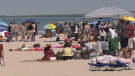
Thousands flock to Simcoe County beaches during long weekend
The Victoria Day long weekend brought crowds to Simcoe County, with beaches and highways bustling with activity.
-
What's open and closed on Victoria Day
On Monday, Government offices and services that will be closed include:
-
Two people rescued from house fire in Orillia
Fire crews battled a large house fire in Orillia early Saturday morning.
Kitchener
-

Two people injured in robbery at Fairview Park Mall: police
A police investigation is underway after a jewellery store at Fairview Park Mall in Kitchener was robbed.
-
Police investigating shooting at Waterloo business
No injuries were reported after an overnight shooting at a Waterloo business.
-
What's closed for Victoria Day in Waterloo Region
Before you head out the door Monday, see what's open and closed for Victoria Day.
London
-

Vehicle submerged in Sarnia Bay
Sarnia Police, assisted by Lambton EMS, are investigating after a car ended up in the Sarnia Bay.
-
As missing St. Thomas, Ont. man turns 35, family still hopeful he’ll be found
Kyle Hancock turned 35 Friday, however his family wasn’t able to celebrate with their loved one.
-
Damian Warner wins 8th Gotzis Decathlon at age 34
Damian Warner has done it again. The 34 year old from London, Ont. won the renowned Hypomeeting in Gotzis, Austria for the eighth time Sunday.
Windsor
-

Two pedestrians killed in Chatham-Kent collision
Emergency crews responded to a motor vehicle collision on Charing Cross Road and Horton Line just after 7 p.m. Saturday.
-
7-year-old Pokémon prodigy heading to Hawaii for world championship tournament
Catching 'em all with impressive speed, a 7-year-old boy from Windsor, Ont. who only started his competitive Pokémon journey seven months ago has already levelled up to compete at a world championship level.
-
'A horrible way to start the summer': 3 killed in serious boat crash on lake north of Kingston, Ont.
Three people were killed and five others were injured Saturday night following a boat crash on the Buck Bay area of Bobs Lake, north of Kingston, Ont., the Ontario Provincial Police (OPP) said.


