Calgary gets another blast of winter weather this weekend
 Calgary's skyline can be seen on a cold winter evening.
UPDATE: The models are in. I'm not budging, but I'll add an asterisk. 10--15 cm is still the region we're aiming for in Calgary, but Calgary will likely fall on the cusp of a heavier region, where that 20 cm marker is very much within sight. There's a chance this band of snow sags that far south before it continues the journey east-southeastward. For spots in Alberta to get a snowfall warning, we need to see 10+ cm of snow falling in 12 hours or less. There's a chance for that too, to the north or west of our city.
The cold weather trend continues, but the light at the end of a chilly tunnel is starting to reveal more for Wednesday, as opposed to before, where it was stuck in the cold. Our wind and temperature combinations will push wind chills to the minus 30s.
The trough swinging down from the Polar Regions extends well into the US, and has us set up under northwesterly flow for the day – the key word there will most certainly be "north."
Following morning flurries, we'll get some afternoon sunshine and a slowly-rising temperature.
The trend will continue through the night and into Saturday morning, where gusts will hit the 40 to 50 km/h marker overnight. Later in the day, we hit our last high above 5 C for a while. Then… things take a turn.
A low from the far northwest slings itself into northern Alberta. The cold front from this activates a number of features; strong gusts along the southern foothills regions, with a possibility of brief thunderstorms – that's a lot of instability! Gusts in the southwest may peak into warning criteria. And lastly: snow. And plenty of it. Calgary still aligns with Thursday's look at 10 to 15 centimeters, half of which will fall before Sunday morning. The remainder will carry out through the day Sunday and into Monday.
Beyond, the cold air mass will linger, not letting up until at least Thursday of next week. Bundle up, and take a solid amount of extra time, especially for that Sunday drive.
Your five-day forecast:
Tonight
- Evening: some cloud, low -3 C
Saturday
- Building cloud, evening snow
- Daytime high: 9 C
- Evening: snow, low -15 C
Sunday
- Snow
- Daytime high: -15 C
- Evening: some cloud, low -22 C
Monday
- AM flurries, partly cloudy
- Daytime high: -18 C
- Evening: some cloud, low -24 C
Tuesday
- Sunny
- Daytime high: -13 C
- Evening: clear, low -17 C
Wednesday
- Partly cloudy
- Daytime high: -5 C
- Evening: some cloud, low -9 C
Our picture of the day for Friday was taken by Sharon. It shows a lovely sun pillar, which forms when ice crystals are positioned just right and reflect the sun's rays vertically.
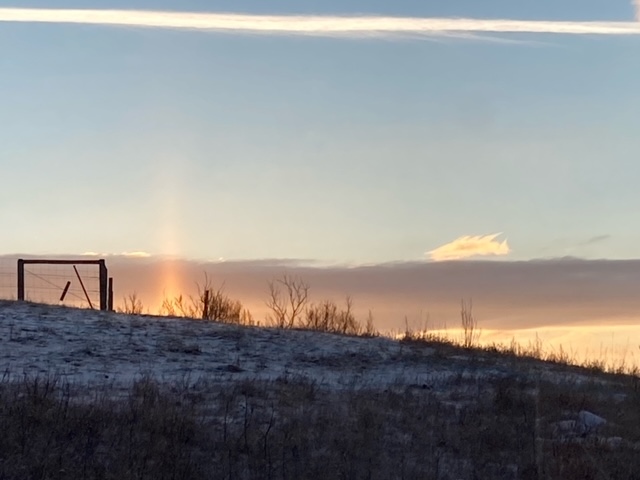 A photo of a sun pillar submitted by CTV News viewer Sharon. (supplied) You can submit your photos here, email me here, or tweet them over! We’re also freshly minted on Instagram and waiting on a few approvals before daily posts pop up there: @CTVCalgaryWeather.
Shopping Trends
The Shopping Trends team is independent of the journalists at CTV News. We may earn a commission when you use our links to shop. Read about us.


CTVNews.ca Top Stories

Trump making 'joke' about Canada becoming 51st state is 'reassuring': Ambassador Hillman
Canada’s ambassador to the U.S. insists it’s a good sign U.S. president-elect Donald Trump feels 'comfortable' joking with Canadian officials, including Prime Minister Justin Trudeau.
Mexico president says Canada has a 'very serious' fentanyl problem
Foreign Affairs Minister Mélanie Joly is not escalating a war of words with Mexico, after the Mexican president criticized Canada's culture and its framing of border issues.
Quebec doctors who refuse to stay in public system for 5 years face $200K fine per day
Quebec's health minister has tabled a bill that would force new doctors trained in the province to spend the first five years of their careers working in Quebec's public health network.
Freeland says it was 'right choice' for her not to attend Mar-a-Lago dinner with Trump
Deputy Prime Minister and Finance Minister Chrystia Freeland says it was 'the right choice' for her not to attend the surprise dinner with Prime Minister Justin Trudeau at Mar-a-Lago with U.S. president-elect Donald Trump on Friday night.
'Sleeping with the enemy': Mistrial in B.C. sex assault case over Crown dating paralegal
The B.C. Supreme Court has ordered a new trial for a man convicted of sexual assault after he learned his defence lawyer's paralegal was dating the Crown prosecutor during his trial.
Bad blood? Taylor Swift ticket dispute settled by B.C. tribunal
A B.C. woman and her daughter will be attending one of Taylor Swift's Eras Tour shows in Vancouver – but only after a tribunal intervened and settled a dispute among friends over tickets.
Eminem's mother Debbie Nelson, whose rocky relationship fuelled the rapper's lyrics, dies at age 69
Debbie Nelson, the mother of rapper Eminem whose rocky relationship with her son was known widely through his hit song lyrics, has died. She was 69.
NDP won't support Conservative non-confidence motion that quotes Singh
NDP Leader Jagmeet Singh says he won't play Conservative Leader Pierre Poilievre's games by voting to bring down the government on an upcoming non-confidence motion.
Canadians warned to use caution in South Korea after martial law declared then lifted
Global Affairs Canada is warning Canadians in South Korea to avoid demonstrations and exercise caution after the country's president imposed an hours-long period of martial law.
Edmonton
-

Alberta transportation minister says photo radar cuts aren't a safety risk
Alberta’s transportation minister rejects accusations a move to reduce photo radar enforcement puts lives at risk.
-
Selective federal tax break leaving some businesses feeling left out
The upcoming tax holiday announced by the federal government is leaving some businesses scrambling ahead of a busy season.
-
Ex-Elks CEO to lead provincial look into combative sports safety
Victor Cui, former president and chief executive officer of the Edmonton Elks, has been appointed to head a provincial effort to improve safety in Alberta combative sports.
Lethbridge
-

Lethbridge charities worry Canada Post strike is impacting donations
The Canada Post strike has come at a difficult time of year for most Canadians, but for Lethbridge charities it's the worst-case scenario.
-
Residents debate Grassy Mountain coal mining project applications at public hearing
Residents in favour and against coal mining in the Eastern Slopes had the chance to have their voices heard as a public hearing for three applications by Northback got underway in Pincher Creek Tuesday.
-
Hurricanes add Yager, Unger in blockbuster deal with Warriors
The Lethbridge Hurricanes received forward Brayden Yager and goalie Jackson Unger from the Moose Jaw Warriors in an 11-asset blockbuster trade on Monday.
Vancouver
-

Trump's apparent joke about Canada becoming 51st state draws range of reaction in B.C.
Revelations about a cheeky comment during a dinner meeting at president-elect Donald Trump's Mar-a-Lago resort between Trump and Prime Justin Minister Trudeau last week are creating waves.
-
'I leave my limitations behind': Patients react to new program on G.F. Strong's 75th anniversary
G.F. Strong Rehabilitation Centre in Vancouver celebrated its 75th anniversary on Tuesday.
-
B.C. police failing to enforce 'restraining orders' too often, report finds
Inconsistent policework is leaving too many B.C. women vulnerable as they attempt to flee from intimate-partner violence, according to a new report highlighting a range of issues plaguing the province’s system of protection orders and peace bonds.
Vancouver Island
-

Longest continually run Chinese business in North America gets a new owner, preserving bragging rights
In the oldest Chinatown in the entire country sits Loy Sing, a business that holds the title of longest continually run Chinese business in North America. It has now been in operation for 136 years and counting.
-
Trump's apparent joke about Canada becoming 51st state draws range of reaction in B.C.
Revelations about a cheeky comment during a dinner meeting at president-elect Donald Trump's Mar-a-Lago resort between Trump and Prime Justin Minister Trudeau last week are creating waves.
-
Giving Tuesday campaign targets support for Victoria health centre
A Greater Victoria non-profit has launched a $1.5-million fundraising campaign to build a health centre on the main floor of its Crosstown development.
Saskatoon
-

'Helping new entrepreneurs': Gather Local Market lets potential food businesses test out product
With seven months under their belt, Gather Local Market at River Landing continues to try new ideas to move their concept forward. The latest addition is helping small businesses get off the ground.
-
Major power outage hits much of Saskatoon's west side
A large power outage lasting several hours affected much of Saskatoon's west side and portions of the east side of the city Tuesday afternoon.
-
'That's way, way inappropriate': Saskatoon city councillor raises issue with democratic process, clerk apologizes
Before Saskatoon city council unanimously approved the budget, a fiery discussion about the democratic process dominated chambers.
Regina
-

Regulations around foreign ownership of Sask. farmland need better enforcement, auditor finds
The Provincial Auditor of Saskatchewan is recommending that the province improve its system of monitoring sales of farmland to foreign entities.
-
Weyburn RCMP respond to crash on Highway 13
A two vehicle collision resulted in a police presence on Highway 13 in southeastern Saskatchewan Tuesday night.
-
Regina Food Bank donations impacted by Canada Post strike, in person donations encouraged
The ongoing Canada Post strike has forced a number of charitable organizations to rethink their holiday donation strategies, including the Regina Food Bank.
Toronto
-

Richmond Hill jewelry store smash-and-grab caught on video, 5 suspects outstanding
Video footage has surfaced on social media of a violent daytime robbery earlier this week at a jewelry store in a Richmond Hill shopping centre.
-
Walking pneumonia cases in Ontario have nearly tripled since 2019: report
The number of walking pneumonia cases seen in Ontario this year is triple the amount of what was reported in 2019, before the COVID-19 pandemic.
-
Process around Ontario Place redevelopment was 'unfair' and didn't follow rules: AG
Ontario's auditor general is slamming the Ford government for failing to follow proper process around the redevelopment of Ontario Place, including a revelation that senior staff communicated directly with Therme Canada and other applicants while proposals were still being accepted.
Montreal
-

Quebec doctors who refuse to stay in public system for 5 years face $200K fine per day
Quebec's health minister has tabled a bill that would force new doctors trained in the province to spend the first five years of their careers working in Quebec's public health network.
-
Despite devastating poll, Quebec Premier Legault confident he’s here to stay
Despite a devastating poll, Premier François Legault is confident that he will lead the CAQ troops into the next electoral battle in two years' time.
-
MISSING PERSON
MISSING PERSON New York police seek public's help in search for missing Montreal-area hiker in Adirondacks
Police in New York are asking for the public's help in searching for a missing hiker from the Montreal area who has been missing for several days.
Atlantic
-

Snow, rain, and wind expected for Maritimes this week with early December storm
A developing low pressure skirting colder air in place across eastern parts of the country will bring snow, rain, and wind to the Maritimes on Thursday.
-
Cape Breton investigating last year of municipal credit card transactions
The Cape Breton Regional Municipality (CBRM) is investigating more than a year of transactions on a legislative credit card due to a lack of documents.
-
'It moved me': Person returns stolen purse to Halifax store; owner donates proceeds
A Halifax store owner says a person returned a Prada bag after allegedly stealing it.
Winnipeg
-

Every Winnipeg driver pulled over during checkstop program must give breath sample: police
Every driver pulled over in Winnipeg as part of the police’s annual festive season checkstop program will have to provide a breath sample.
-
'Terrified and outraged': Winnipeg English language school to close following federal funding cuts
A school for English language learners in Winnipeg will be shutting its doors for good.
-
Pembina Trails School Division dealing with 'cyber security incident', classes continuing
People within the Pembina Trails School Division are being told to watch for any unusual activity as the division is currently dealing with a “cyber security incident.”
Ottawa
-
 TRAVEL ADVISORY
TRAVEL ADVISORY Winter weather travel advisory in effect as Ottawa expects first notable snowfall
The first winter weather travel advisory of the season is in effect for Ottawa as the city's first dump of snow expected this week.
-
1 teen, 4 adults injured in crash involving school bus and vehicle in south Ottawa
Ottawa paramedics say five people were injured following a collision between a school bus and a van in south Ottawa.
-
'Adapting is huge': Skiers, snowboarders prepare for first significant snowfall
Winter sports enthusiasts are looking forward to the coming snowfall in eastern Ontario, as are ski resorts, which have had a slow start to the season.
Barrie
-

Snow-clearing efforts stalled due to tractor-trailers stuck on many roads along Highway 11
Snow-clearing efforts continue on secondary roads that remain closed along Highway 11 on Tuesday.
-
Woman dies in two-vehicle crash on Highway 118 in Haliburton
An 87-year-old woman has died following a collision on Highway 118 in Haliburton County on Monday afternoon.
-
Crown pushes for 6-year sentence for supervisor convicted in fatal crash case
Victim impact statements were read in a Barrie courtroom on Tuesday ahead of sentencing for a man convicted of criminal negligence causing the death of a dump truck driver four years ago.
Kitchener
-

Three youths fall through ice at Cambridge pond
The Waterloo Regional Police Service has issued a public plea after three youths fell through the ice at a Cambridge pond.
-
Blowing snow could cause problems for drivers Wednesday
More snow is headed for southwestern Ontario on Wednesday and it could reduce visibility on the roads.
-
Why Wilmot is proposing a $580 tax increase in its 2025 draft budget
The Township of Wilmot has released its 2025 draft budget which included a one-time capital infrastructure investment.
London
-

Witness sees accused with gun at bush bash shooting scene
A witness for the bush party shooting trial says he saw the accused with a firearm that night.
-
'A real gamut': LHSC highlights number of serious seasonal injuries ahead of the holiday season
As we head into the heart of the holiday season, experts at London Health Sciences Centre (LHSC) are cautioning the public in order to help prevent serious injuries.
-
Tire shops 'spinning' with winter tire changeover demand
London tire and automotive shops remain caught off guard by the sudden arrival of winter.
Windsor
-

Windsor, mayor name-dropped for housing criticism
The City of Windsor and its mayor have been picked out as egregious examples of municipal housing missteps by a prominent expert in the field and author of a recent report identifying poor building performance in Ontario.
-
Survey raises concerns about cannabis-impaired driving in Ontario
A recent survey conducted by CAA South Central Ontario (CAA SCO) highlights an increase in cannabis use among Ontario drivers, sparking some concern about impaired driving.
-
Could a co-pay model save the IB and RISE programs?
Windsor-Essex parents are proposing a co-pay model to keep the International Baccalaureate (IB) program running in the Greater Essex County District School Board (GECDSB), but the board’s chair says it’s not feasible.


