Calgary got a month's worth of snow in 2 days, more expected this weekend

Spring is a transitional season in Calgary and as such, has historically includes the snowiest month of the year (March) which averages 22.7 centimetres of snow, according to Environment and Climate Change Canada's (ECCC) 30-year 'climate normals' data.
Before this week, March 2024 had already exceeded that monthly average, thanks to a snowy start when 25.3 centimetres fell at YYC Calgary International Airport between March 1 and 6.
The snow from this past week has this month now at more than double the March monthly average.
As expected, the Calgary area saw varying snowfall totals during the recent multi-day snowfall event.
In a weather summary Friday morning, ECCC noted the airport recorded 23 centimetres of snow from Tuesday night until Thursday evening, with third party reports of 10 to 20 centimetres in Calgary.
Other snowfall totals recorded at ECCC weather stations include (in centimetres): Sundre (18), Brooks and Medicine Hat (15), Lethbridge (14), Rocky Mountain House, Waterton and Claresholm (12), Banff (7) and the Edmonton International Airport (5).
More snow is expected in southern Alberta in the coming days, but there is model disagreement regarding how much snow Calgary will receive.
The incoming precipitation will enter the province over the southern Foothills, and be enhanced by the same synoptic setup that produced upsloping flow this week (pushing moisture back into the foothills due to the counter-clockwise circulation around the low pressure system over southern Alberta and B.C.)
The area of disagreement comes in how far north the snow will migrate north.
Some models suggest Calgary will sit on the northern edge of the incoming system and receive minimal amounts, and other models are forecasting another wave of heavy snow for the Calgary area.
These are very difficult scenarios to forecast for, due to the Rocky Mountains and their impact on weather as well as the southern entry point of this moisture.
It is likely Calgary will see an additional three to five centimetres of snow on Friday with another five to eight centimetres Saturday, but this will be an evolving scenario.
The Calgary region could also end up with either a lot more or a lot less snow than that.
Daytime highs will stay colder for the next four days (around 11 to 13-degrees below the seasonal 5 C) and overnight lows are expected to range from -9 C to -12 C until Monday.
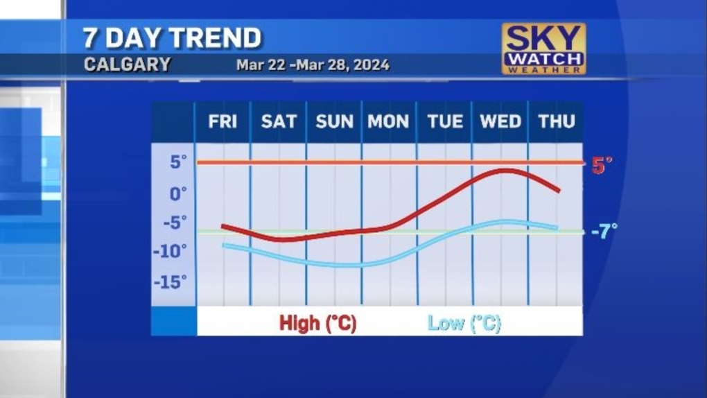 The southerly-riding polar jet should move east early next week making room for a ridge of high pressure that will edge into Alberta and B.C. and bring more sunshine into the Calgary area
Daytime highs are expected to hit 4 C by Wednesday – and while that is an improvement, it is still slightly below-seasonal.


CTVNews.ca Top Stories

Chants of 'shame on you' greet guests arriving for the annual White House correspondents' dinner
An election-year roast of U.S. President Joe Biden before journalists, celebrities and politicians at the annual White House correspondents' dinner Saturday.
What is a 'halal mortgage'? Does it make housing more accessible?
The 2024 federal budget announced on April 16 included plans to introduce “halal mortgages” as a way to increase access to home ownership.
Here's where Canadians are living abroad: report
A recent report sheds light on Canadians living abroad--estimated at around four million people in 2016—and the public policies that impact them.
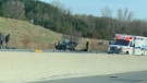
Deadly six-vehicle crash on Highway 400 sparked by road rage incident
One person was killed in a six-vehicle crash on Highway 400 in Innisfil Friday evening.
Opinion
Opinion I just don't get Taylor Swift
It's one thing to say you like Taylor Swift and her music, but don't blame CNN's AJ Willingham's when she says she just 'doesn't get' the global phenomenon.
Invasive and toxic hammerhead worms make themselves at home in Ontario
Ontario is now home to an invasive and toxic worm species that can grow up to three feet long and can be dangerous to small animals and pets.
Harvey Weinstein hospitalized after return to New York from upstate prison
Harvey Weinstein’s lawyer said Saturday that the onetime movie mogul has been hospitalized for a battery of tests after his return to New York City following an appeals court ruling nullifying his 2020 rape conviction.
'We are declaring our readiness': No decision made yet as Poland declares it's ready to host nuclear weapons
Polish President Andrzej Duda says while no decision has been made around whether Poland will host nuclear weapons as part of an expansion of the NATO alliance’s nuclear sharing program, his country is willing and prepared to do so.
Central Alberta queer groups react to request from Red Deer-South to reinstate Jennifer Johnson to UCP caucus
A number of LGBQT+2s groups in Central Alberta are pushing back against a request from the Red Deer South UCP constituency to reinstate MLA Jennifer Johnson into the UCP caucus.
Shopping Trends
The Shopping Trends team is independent of the journalists at CTV News. We may earn a commission when you use our links to shop. Read about us.


Edmonton
-

Oilers coach calls McDavid and Draisaitl’s playoff performances remarkable
Kris Knoblauch is five months into watching Connor McDavid and Leon Draisaitl go to work.
-
'It's been a godsend': Free store for Ukrainian newcomers to close Sunday
Two years and $8 million worth of beds, couches, dishes and dressers later, the Ukrainian Newcomer Free Furniture Warehouse is closing its doors.
-
Toxic testing standoff: Family leaves house over air quality
A Sherwood Park family says their new house is uninhabitable. The McNaughton's say they were forced to leave the house after living there for only a week because contaminants inside made it difficult to breathe.
Lethbridge
-

Bandits get hat trick from Logan Sawyer en route to 8-2 win over Okotoks
The Brooks Bandits got down to business Friday, defeating the Okotoks Oilers 8-2.
-
'No real winner' following first Alberta NDP leadership debate: political scientist
An Alberta political scientist said the NDP leadership hopefuls remained fairly even following the first of the party’s debates.
-
Multiple grass fires sparked near Kipp rail yard
It was a busy Wednesday evening for fire crews in Lethbridge County after multiple grass fires were sparked near the Kipp rail yard.
Vancouver
-

Vancouver is one step closer to getting a Filipino cultural centre, society says
As the Lower Mainland's Filipino community gathered in South Vancouver for Lapu-Lapu Day on Saturday, one of the festival's organizers set its sights on creating a future focal point for such gatherings.
-
B.C. breweries take home awards at World Beer Cup
Out of more than 9,000 entries from over 2,000 breweries in 50 countries, a handful of B.C. brews landed on the podium at the World Beer Cup this week.
-
Powerful penalty kill a big part of playoff success for Vancouver Canucks
The special teams unit has become a strength for the Canucks, particularly in the first-round playoff series against the Nashville Predators which the Canucks lead 2-1 heading into Sunday's Game 4.
Vancouver Island
-

B.C. breweries take home awards at World Beer Cup
Out of more than 9,000 entries from over 2,000 breweries in 50 countries, a handful of B.C. brews landed on the podium at the World Beer Cup this week.
-
Canucks defeat Predators in Game 3, take 2-1 series lead
J.T. Miller had a goal and assist and the Vancouver Canucks edged the Nashville Predators 2-1 to re-take the lead in their first-round playoff series.
-
Haida Elder suing Catholic Church and priest, hopes for 'healing and reconciliation'
The lawyer for a residential school survivor leading a proposed class-action defamation lawsuit against the Catholic Church over residential schools says the court action is a last resort.
Saskatoon
-

Saskatoon care home workers escalating strike action
Workers at group homes run by LutherCare Communities in Saskatoon are escalating their strike action.
-
Saskatoon Indigenous and Palestinian communities gather in collective prayer for Gaza
On Saturday, in a display of cross-cultural solidarity, members of the Indigenous and Palestinian communities gathered in Saskatoon for an event steeped in prayer and dance.
-
Saskatoon police investigating after body found at recycling facility
The Saskatoon Police Service (SPS) and Saskatchewan Coroners Service are investigating after a woman’s body was found at a recycling facility Friday morning.
Regina
-

Regina's Dunlop Art Gallery welcomes new installation
'Feel through the Deepness to see,' an art installation by artist Rita McKeough, will be calling the Dunlop Art Gallery home for the next two months.
-
Annual model train showcase rolls into Regina
Regina's annual model train showcase rolled into town this weekend at the Caledonian Curling Club.
-
Commissionaires at RPL Central Branch named regional team of the year
The team of Commissionaires at The Regina Public Library’s downtown branch have received one of the organization’s top honours.
Toronto
-
 BOS LEADS TOR 3-1
BOS LEADS TOR 3-1 Marchand stars again, Swayman solid as Bruins push frustrated Leafs to the brink
Brad Marchand became the Bruins' all-time leading playoff goal-scorer and added an assist as Boston suffocated the Toronto Maple Leafs 3-1 on Saturday to take a 3-1 lead in the teams' first-round playoff series.
-
Murder charge laid after man falls to death from Toronto apartment balcony
One person has been charged with second-degree murder in connection with the death of a man who fell from a balcony following an altercation inside a Toronto apartment building.
-
Invasive and toxic hammerhead worms make themselves at home in Ontario
Ontario is now home to an invasive and toxic worm species that can grow up to three feet long and can be dangerous to small animals and pets.
Montreal
-

'Divest now': Students launch encampment at McGill University
Several students have launched an encampment at McGill University as they call on the institution to cut financial ties with Israel.
-
Transit trips up among seniors since Montreal introduced free fare program, city says
Montreal says public transit trips were up between 15 and 20 per cent among people age 65 and over in the six months after it made the service free for local seniors.
-
Driver arrested after woman, 51, dies in head-on collision in Lachute
Quebec provincial police say a 51-year-old woman has died after a head-on collision in the town of Lachute, roughly 50 kilometres west of Montreal, early this morning.
Atlantic
-

Bidders express interest in buying all or part of SaltWire newspaper business
A Toronto-based restructuring firm says several bidders have offered to buy all or part of SaltWire Network and The Halifax Herald, the two insolvent companies that operate Atlantic Canada's largest newspaper enterprise.
-
Halifax Wanderers kick off season with home opener against Ottawa
Halifax’s professional soccer team kicks off its sixth season against Ottawa on Saturday with a sold-out crowd of 6,500 fans on the Wanderers Grounds.
-
New Brunswick strongest men and women compete in Saint John for title of strongest in the province
“This is the largest year we’ve had”: annual provincial strongman competition sees record levels of participation and support with 55 athletes taking part
Winnipeg
-

A timeline of the Jeremy Skibicki case
The trial for the man accused of killing four Indigenous women in Winnipeg is set to get underway on April 29.
-
Canadian history sizes down in small scale model competition
A Winnipeg scale model builder is using his craft to showcase a large piece of Canadian history in miniature form.
-
Ice pileup warnings for Lake Manitoba and Lake Winnipeg this weekend
With heavy wind gusts expected along Lake Manitoba and Lake Winnipeg this weekend, the provincial government is warning residents and property owners about potential ice pileups.
Ottawa
-

What is a 'halal mortgage'? Does it make housing more accessible?
The 2024 federal budget announced on April 16 included plans to introduce “halal mortgages” as a way to increase access to home ownership.
-
Ottawa woman, 47, facing charges following downtown hate crimes
The Ottawa Police Service says a 47-year-old woman is facing charges following a series of hate crimes in the downtown area last week.
-
No injuries reported following single-vehicle collision on Highway 15 in eastern Ontario
The Ontario Provincial Police (OPP) asked drivers to expect delays after a single-vehicle collision on Highway 15 near Brewers Mills Road Saturday morning.
Northern Ontario
-
Severe thunderstorm watch in effect for Sudbury, West Nipissing
Environment Canada issued a severe thunderstorm watch for several communities in northeastern Ontario on Saturday afternoon – primarily the Greater Sudbury area and West Nipissing.
-
Deadly six-vehicle crash on Highway 400 sparked by road rage incident
One person was killed in a six-vehicle crash on Highway 400 in Innisfil Friday evening.
-
French River area preparing for more flooding with weekend rain expected
The Municipality of French River has been under a flood watch since Thursday evening and many residents told CTV News that they fear the already high water levels combined with the rain forecasted in the coming days may cause more widespread flooding.
Barrie
-
Deadly six-vehicle crash on Highway 400 sparked by road rage incident
One person was killed in a six-vehicle crash on Highway 400 in Innisfil Friday evening.
-
Police investigating after senior drowns in Meaford
Police in Meaford are investigating after a senior drowned Saturday morning.
-
All things maple syrup celebrated at annual Elmvale festival
Despite the poor weather, a festival celebrating all things maple syrup drew thousands of people to Elmvale on Saturday.
Kitchener
-

Kitchener family says their 10-year-old needs life-saving drug that cost $600,000
Raneem, 10, lives with a neurological condition and liver disease and needs Cholbam, a medication, for a longer and healthier life.
-
Pedestrian seriously hurt following hit-and-run crash in Cambridge, driver arrested
A driver has been arrested and a pedestrian has been seriously injured following a hit-and-run crash in Cambridge.
-
Cambridge Moves for Mental Health draws dozens in spite of weather
Rainy weather for the second year in a row once again did not deter attendees from a special fundraising event.
London
-

5.5% of registered voters cast early ballots in Lambton-Kent-Middlesex by-election
Approximately 5.5 per cent of registered voters have cast their ballot as advanced polling in the Lambton-Kent-Middlesex by-election gets underway.
-
Fatal crash victim identified as 24-year-old Western University graduate
A 24-year-old man who died Friday in a car crash on Highway 401 has been identified as Omar Barzak from London, Ont.
-
'Beneath all these colours we are all one': Thousands attend Hindu Holi Festival at Victoria Park
London’s Victoria Park was filled with colours Saturday afternoon as those attending Holi threw coloured water and powders into the air in a celebration of spring and unity.
Windsor
-
 VIDEO
VIDEOVIDEO From Windsor high school grad to New York Giant: Theo Johnson selected in NFL Draft
A former graduate of Holy Names Catholic High School in Windsor will soon be moving to New York after being selected during the 2024 NFL Draft.
-
'It’s just life changing': No need to sell home after Windsorite wins 100K
Playing bingo in April made a local resident $100,000 richer -- and will keep him in his home.
-
Alleged hate crimes reported at University of Windsor campus
Campus police are investigating after homophobic slurs were carved into the door of the University of Windsor’s Campus Pride Centre earlier this month.


