Calgary hangs in the 20s for a few days, rain this weekend
UPDATE: This will be a different update; because we're already organized, I've added paragraphs to the two 'Parts' below.
Short is good … usually. We'll divide this weather story into two parts:
Part I: The dry days. Tuesday continues shaping with a high of 20 C. Wind will be marginal, and cloud cover will mix in. If you're headed out tonight for the Flames playoff opener, the forecast is spectacular for it; the temperature at puck drop is holding near 16 C. From Wednesday to Thursday, our upper air will set up to cross the Rockies from more of a southwesterly position. This will make for building gust speeds; Wednesday looks to top near 40 km/h, and Thursday could push things into the 50 km/h range, with a chance for the extreme southwest to push toward wind warning territory.
That cuts off Friday. We'll continue to see warm weather and westerly wind, but it will be far less pronounced. Friday is the "shoulder day" between events.
Our update doesn't modify much. Our models paint Wednesday and Thursday with near-equal strength, but Wedneseday is buffed up a bit thanks to westerly wind, whereas a lot of the predictors have Thursday's wind taking on a southerly approach, now. That impacts the bottom line for our expected highs.
Which brings us to…
Part II: The rainy days. I don't want to get anyone's hopes up just yet, nor dash outdoor plans completely, but the early look has rain now starting earlier in the day; closer to 6 a.m. and with it, stronger showers are now starting to appear in the forecast, which could offer 20+ milllimetres of rain. It's still a ways out. Sunday and Monday, as of now, are shaping for trace amounts of rain, as well. Even if that messes up the family barbecue, we could use it.
This update has a few notes: foremost that we're still far enough away from this event for things to be quite malleable. Rainfall continues slipping earlier and earlier into Saturday in some models, to the point where our Friday evening forecast may involve rain as we get closer and models continue refining — with a high of 18 C slated, maybe even early-season thundershowers in parts of the province.
The troubling thing about this pattern is that the rainfall is coming from the northwest; this is to say, from across the Rockies. That may make for drastic changes, if the entire event shifts north or southward. Right now, our best rainfall estimates range from 15 mm up to 25 mm; there are a couple of less-reliable (AKA: less good at telling what happens east of mountains) forecast models that drop us off in the low single digits, instead.
YOUR FIVE-DAY CALGARY FORECAST:
Tuesday
- Mostly cloudy, low 6 C
Wednesday
- Partly cloudy
- Daytime high: 22 C
- Evening: some cloud, low 8 C
Thursday
- Mainly cloudy
- Daytime high: 22 C
- Evening: shower risk, low 9 C
Friday
- Mainly sunny
- Daytime high: 18 C
- Evening: clearing, low 6 C
Saturday
- Rain
- Daytime high: 10 C
- Evening: clearing, low 5 C
Sunday
- Rain
- Daytime high: 9 C
- Evening: clearing, low 1 C
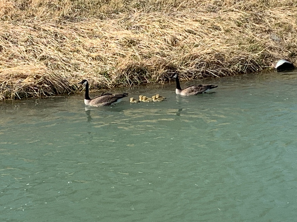
I guess this week's theme is shaping up to be baby animals – here's a lovely little shot from the canal in Lethbridge, sent by a viewer:
Whether it's wildlife, weather or pets – submit your photos here, email me here, or tweet them over.


CTVNews.ca Top Stories

Expert warns of food consumption habits amid rising prices
A new survey by Dalhousie University's Agri-Food Analytics Lab asked Canadians about their food consumption habits amid rising prices.
opinion
opinion The special relationship between King Charles and the Princess of Wales
Royal commentator Afua Hagan writes that when King Charles recently admitted Catherine to the Order of the Companions of Honour, it not only made history, but it reinforced the strong bond between the King and his beloved daughter-in-law.
Charlie Woods, son of Tiger, shoots 81 in U.S. Open qualifier
Charlie Woods failed to advance in a U.S. Open local qualifying event Thursday, shooting a 9-over 81 at Legacy Golf & Tennis Club.
Improve balance and build core strength with this exercise
When it comes to cardiovascular fitness, you may tend to focus on activities that move you forward, such as walking, running and cycling.
B.C. tenants evicted for landlord's use after refusing large rent increase to take over neighbouring suite
Ashley Dickey and her mother rented part of the same Coquitlam duplex in three different decades under three different landlords.
Mountain guide dies after falling into a crevasse in Banff National Park
A man who fell into a crevasse while leading a backcountry ski group deep in the Canadian Rockies has died.
MPP Sarah Jama asked to leave Ontario legislature for wearing keffiyeh
MPP Sarah Jama was asked to leave the Legislative Assembly of Ontario by House Speaker Ted Arnott on Thursday for wearing a keffiyeh, a garment which has been banned at Queen’s Park.
Here's why provinces aren't following Saskatchewan's lead on the carbon tax home heating fight
After Prime Minister Justin Trudeau said the federal government would still send Canada Carbon Rebate cheques to Saskatchewan residents, despite Saskatchewan Premier Scott Moe's decision to stop collecting the carbon tax on natural gas or home heating, questions were raised about whether other provinces would follow suit. CTV News reached out across the country and here's what we found out.
Ex-tabloid publisher testifies he scooped up possibly damaging tales to shield his old friend Trump
As Donald Trump was running for president in 2016, his old friend at the National Enquirer was scooping up potentially damaging stories about the candidate and paying out tens of thousands of dollars to keep them from the public eye.
Shopping Trends
The Shopping Trends team is independent of the journalists at CTV News. We may earn a commission when you use our links to shop. Read about us.


Edmonton
-

UCP able to remove councillors and axe city bylaws in new sweeping bill aimed at municipal politics
The Government of Alberta wants to change how municipalities handle elections and local politics.
-
Oilers 'far superior' to Kings when they're on top of their game: analyst
It's a travel day for the Edmonton Oilers — and some of their fans are along for the ride.
-
Experts urge Albertans to check measles vaccine status after confirmed Edmonton case
A confirmed case of measles in Edmonton has prompted another plea from health officials for people to make sure vaccinations are up to date.
Lethbridge
-

Former U of L student awarded diversity, equity and inclusion medal by NASA
A former University of Lethbridge student has been awarded the Medal for Diversity, Equity, Inclusion and Equity by NASA.
-
Oilers get hat trick from MacNeil en route to 4-1 win over Bandits
The Okotoks Oilers bounced back against the Bandits Wednesday night, defeating Brooks 4-1.
-
Fire risk for southern Alberta high: Natural Resources Canada
It’s not even May 1 and the fire risk for southern Alberta is already alarming.
Vancouver
-

Vancouver developer apologizes for housing scandal at Little Mountain
It’s arguably the biggest social housing scandal in Vancouver’s history and today the developer responsible for the Little Mountain project apologized for the multi-year delay that’s left a massive plot of land vacant during a housing crisis.
-
'So shocking': Roommate of victim left reeling after fatal White Rock stabbing
The roommate and long-time friend of the young man who was killed in White Rock Tuesday night, says he’s still in disbelief over what happened.
-
Inquest into B.C. police shooting deaths recommends emergency events be recorded
An inquest jury looking into the police shooting deaths of a man and the woman he was holding hostage has recommended that events involving the emergency response team be recorded with both video and audio.
Vancouver Island
-

Hiker airlifted to hospital in critical condition after falling into Vancouver Island canyon
A hiker was airlifted to hospital in critical condition Tuesday after he fell approximately 60 metres into a canyon on Vancouver Island.
-
B.C. civil lawsuit against Sex Pistols guitarist alleges 1980 sexual assault
A Vancouver woman has filed a civil lawsuit against Paramount Pictures Corp. and punk rocker Stephen Jones of The Sex Pistols alleging he sexually assaulted her as a teenager while she was a movie extra more than 40 years ago.
-
Harbour Air commits to buying 50 electric engines for seaplane fleet
Harbour Air is travelling towards a more sustainable future, looking to electrify its fleet of 45 aircraft.
Saskatoon
-

Crown argues for life sentence for Sask. Mountie who shot and killed his lover
A Crown prosecutor says the former RCMP officer who shot and killed his lover should be sentenced to life in prison.
-
'Difficult to maintain': Private Sask. school embroiled in abuse allegations may soon close
A private Christian school at the centre of a civil lawsuit and several criminal cases might soon be taken over by an affiliated group, according to a letter obtained by CTV News.
-
Council votes for bike safety improvements at corner where cyclist was killed
Saskatoon city council is making road safety improvements following the death of a cyclist at a busy intersection last year.
Regina
-

RCMP make 2 arrests in connection to Oxbow area homicide
Saskatchewan RCMP have made two arrests in a homicide investigation in the province's southeast.
-
'Get these doctors here': Sask. family calls on province to step up gastroenterologist recruitment
The Weber family is being forced to travel to Toronto due to a lack of pediatric gastroenterologists (GIs) in the province. The family’s situation was highlighted by Saskatchewan’s official opposition.
-
Looking ahead to the upcoming CFL Draft
The draft will take place on Tuesday, April 30, the Saskatchewan Roughriders currently hold the third overall pick.
Toronto
-

'I was scared': Ontario man's car repossessed after missing two repair loan payments
An Ontario man who took out a loan to pay for auto repairs said his car was repossessed after he missed two payments.
-
'Wallet-bursting' housing costs have some Torontonians ditching the city for cheaper pastures
Mauro Quattrochi is facing a decision shared by many in Toronto: commit to a “wallet-bursting life in the city, or a car-bound, almost-as-expensive life outside it?”
-
Subway service on Line 2 partially shutdown after fire: TTC
The TTC says riders using part of Line 2 can expect to face some delays this morning.
Montreal
-

Body of Quebec man who died in Cuba found in Russia, family confirms
A Montreal-area family confirmed to CTV News that the body of their loved one who died while on vacation in Cuba is being repatriated to Canada after it was mistakenly sent to Russia.
-
Man charged with murder in death of 78-year-old woman near Quebec City
A 33-year-old man has been charged with second-degree murder in connection with the death of a woman in her 70s in Montmagny, in the Chaudière-Appalaches region of Quebec.
-
Montreal actress calls Weinstein ruling 'discouraging' but not surprising
A Montreal actress, who has previously detailed incidents she had with disgraced Hollywood producer Harvey Weinstein, says a New York Court of Appeals decision overturning his 2020 rape conviction is 'discouraging' but not surprising.
Atlantic
-

'They followed their gut': N.B. RCMP say wellbeing check led to rescue of human trafficking victims
The New Brunswick RCMP say a wellbeing check that led to the rescue of three women from alleged human trafficking in Moncton earlier this month was the result of someone following their gut.
-
N.S. residents arrested at New Brunswick border with multiple weapons
Canadian Border Services Agency (CBSA) officers arrested two Nova Scotia residents at the New Brunswick border after they seized multiple prohibited firearms.
-
2 teens charged in Halifax homicide: police
Two teenagers have been charged with second-degree murder in connection to an alleged homicide near the Halifax Shopping Centre earlier this week.
Winnipeg
-

'Deep ignorance': Calls for Manitoba trustee to resign sparked after comments about Indigenous people and reconciliation
A rural Manitoba school trustee is facing calls to resign over comments he made about Indigenous people and residential schools earlier this week.
-
Former Manitoba premier Heather Stefanson leaving politics after 23 years
Former Manitoba premier Heather Stefanson is resigning her legislature seat and leaving political life.
-
Arrest made in 2021 northern Manitoba double homicide: RCMP
Manitoba RCMP have arrested a suspect in relation to a 2021 double homicide in a remote northern community.
Ottawa
-
 NEW THIS MORNING
NEW THIS MORNING The Almonte Hospital's mystery March baby boom
This spring has been full of life in Almonte, as the local hospital has seen its biggest baby boom in recent memory.
-
NEW THIS MORNING
NEW THIS MORNING What's happening in Ottawa this weekend: April 26-28
CTVNewsOttawa.ca looks at things to do in Ottawa during the final weekend of April.
-
Criminal charge laid in 2023 hedge trimming death; company owner pleads guilty to Ministry of Labour charge
The supervisor of a 20-year-old man who died after he was electrocuted while trimming hedges in Manotick in May 2023 has been charged with criminal negligence causing death. Meanwhile, the company owner has pleaded guilty to a charge laid by the Ministry of Labour.
Northern Ontario
-

Former head of Ont. tech company charged in $6M fraud case
A years-long fraud investigation by the Ontario Provincial Police’s anti-rackets branch has resulted in fraud and other charges for the former head of BioNorth Technology Group, Frank Benincasa
-
Secret $70M Lotto Max winners break their silence
During a special winner celebration near their hometown, Doug and Enid shared the story of how they discovered they were holding a Lotto Max ticket worth $70 million and how they kept this huge secret for so long.
-
Fire victims in Timmins say thieves have stolen their personal belongings
A month after an accidental fire forced more than 100 people out of their apartments at the Empire Complex in Timmins, residents are now dealing with being victims of theft.
Barrie
-

Honda unveils $15B investment plan to build new EV plant in Alliston
Prime Minister Justin Trudeau and Premier Doug Ford visited Alliston on Thursday to unveil a $15 billion investment in an electric vehicle and battery facility.
-
Secret $70M Lotto Max winners break their silence
During a special winner celebration near their hometown, Doug and Enid shared the story of how they discovered they were holding a Lotto Max ticket worth $70 million and how they kept this huge secret for so long.
-
One person charged following shootings in Bradford
One person has been charged following a series of shootings in August and September in Bradford West Gwillimbury.
Kitchener
-

Generational farm could be impacted if Wilmot land assembly goes ahead
A family of farmers say their operations would be significantly impacted if the Region of Waterloo goes ahead with a land assembly project in the Wilmot Township area.
-
Former Kitchener doctor accused of sexually assaulting patients makes brief court appearance as marathon trial continues
The trial for former neurologist Jeffrey (Scott) Sloka began two and a half years ago, and it remains unclear when there may be a verdict.
-
Drivers who got bad fuel from Guelph, Ont. gas station receiving compensation
Drivers who were hit with hefty repair bills after fueling up at a Guelph gas station appear to be finally getting their money back.
London
-

Fatal crash closes section of Highway 401
A fatal crash in Thames Centre has closed down a portion of Highway 401 westbound. Around 2:15 a.m., first responders were called to westbound lanes of the highway between Culloden and Putnam Roads for a two-vehicle crash.
-
Aamjiwnaang First Nation declares state of emergency over benzene levels
On Thursday, Aamjiwnaang First Nation Chief Chris Plain declared a state of emergency due to the high levels of benzene.
-
Tentative agreement reached between GTAs and Western
The union representing western's graudate teacher's assistants says a tentative agreement has been reached with the university.
Windsor
-

Local job protection a concern as Canada's auto sector faces EV renaissance
Canada's auto industry is experiencing a renaissance as it transitions from building gas-powered vehicles to ones that run on batteries, but some are raising the alarm over the protection of local jobs.
-
Preparations underway for Wheatley demos
Preparations are underway for the demolition of nine building that remain fenced off from the explosion that rocked the downtown core of Wheatley in 2021, injuring 20 people.
-
Fatal crash closes section of Highway 401
A fatal crash in Thames Centre has closed down a portion of Highway 401 westbound. Around 2:15 a.m., first responders were called to westbound lanes of the highway between Culloden and Putnam Roads for a two-vehicle crash.


