Evening thundershower risk for Calgary; rainy for the next few days
AFTERNOON UPDATE: Very recently, a few severe thunderstorm watches sprang up from Environment Canada for the evening's events:
This morning, I mentioned the small chance of this populating much closer to Calgary - even now, I'm sticking to it.
Rainfall totals in the coming days are quite variable, but the Monday precipitation potential has stayed the course; a few models painted for an earlier start to showers, and that just hasn't panned. Tuesday still offers some measure of instability, as does Wednesday now, but barring actual storms, evening sports should hold steady, due to the lightness of those showers.
Thursday could remain the outlier, with a precipitation total somewhere between 10-20 mm, wrapping by miudday Friday.
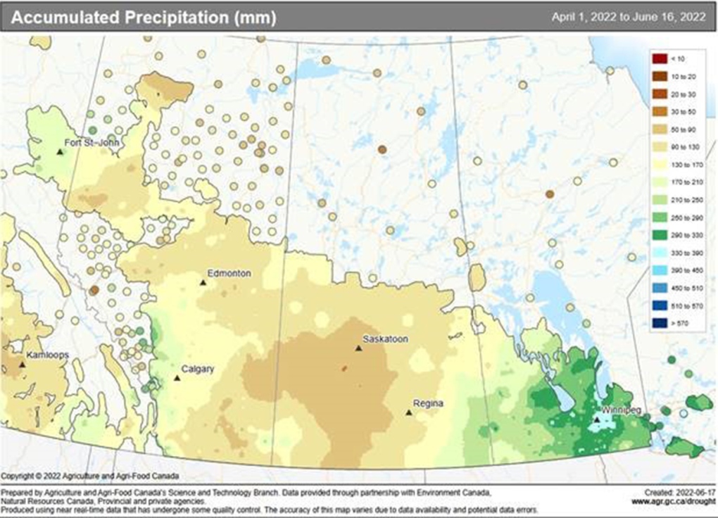
MORNING EDITION: A caveat with this post: I know it's not a fix, and I'll get to that right after. Our first map here is growing season precipitation – this only dates out as far as June 16, and so will not include the ~eight millimetres we’ve had over the past couple of days.
Our second map is the same data spam, but showing our "departure from normal" relative to seasonal conditions:
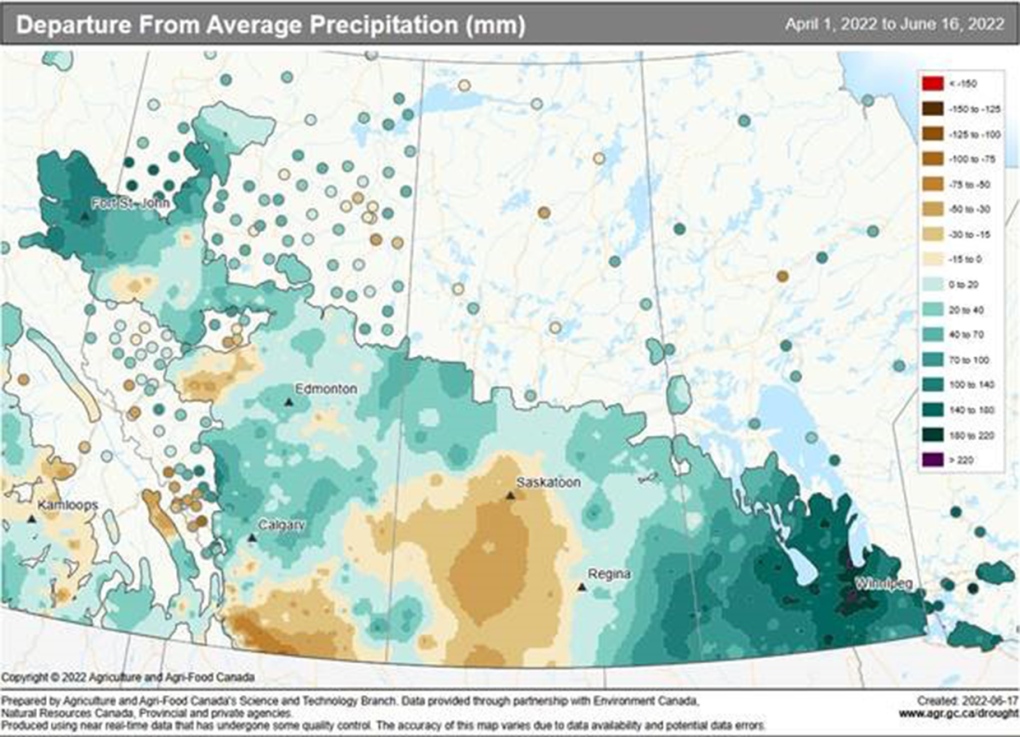
Why it's not a perfect fix: For one, ongoing dry conditions persist in the southern reaches. Two, areas that are at or above a seasonal precipitation total now only did so in the past couple of weeks; while this moisture is great for growing, the season started a while ago, and dry conditions through May, especially, didn't do our farmer friends any favours.
I cannot speak as an agriculture expert, but here's hoping a number of crops got the bolster they needed.
…and if not quite yet, this is the week to help them out, and the week to catch up on your reading or that show you've been missing out on.
Similar to yesterday, showers – and isolated severe storms – will push from the foothills and drive in a few millimetres of rain in parts of the city. These storms will be marginal, and less likely to produce severe watches or warnings.
We'll repeat this trend Tuesday, then wrap into an Alberta low Wednesday and beyond, which has no mechanisms to hold it here; Wednesday will be somewhat dreary, but should open to the heaviest rain the week can offer through Thursday. Friday is looking lighter for now, but I'd be unsurprised if later this week, it splits the difference with Thursday.
It'll be a good one for a late spring cleaning.
YOUR FIVE-DAY CALGARY FORECAST
Monday
- Evening: mainly cloudy, scattered showers, low 8 C
Tuesday
- Partly cloudy, scattered showers, chance of thundershowers
- Daytime high: 22 C
- Evening: mainly cloudy, low 11 C
Wednesday
- Mainly cloudy, scattered showers
- Daytime high: 23 C
- Evening: mainly cloudy, low 9 C
Thursday
- Rain
- Daytime high: 12 C
- Evening: showers, low 7 C
Friday
- Cloudy, scattered showers
- Daytime high: 14 C
- Evening: showers, low 6 C
Saturday
- Partly cloudy
- Daytime high: 18 C
- Evening: some cloud, low 8 C
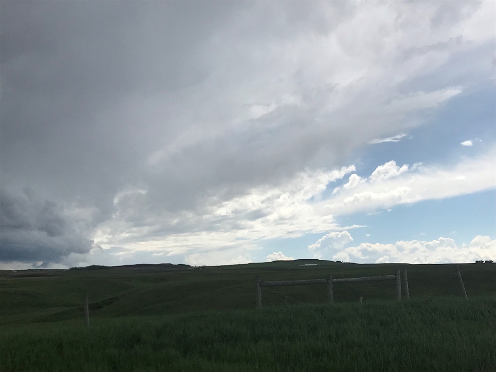
Today's pic is a lovely summer scene sent in by Shannon in Balzac:
Submit your weather photos here to see them featured in our article, and perhaps even as the pic of the day during our news at six! You can also share my way on Twitter, or to our Instagram at @CTVCalgaryWeather.


CTVNews.ca Top Stories

More than 115 cases of eye damage reported in Ontario after solar eclipse
More than 115 people who viewed the solar eclipse in Ontario earlier this month experienced eye damage after the event, according to eye doctors in the province.
Toxic testing standoff: Family leaves house over air quality
A Sherwood Park family says their new house is uninhabitable. The McNaughton's say they were forced to leave the house after living there for only a week because contaminants inside made it difficult to breathe.
Decoy bear used to catch man who illegally killed a grizzly, B.C. conservation officers say
A man has been handed a lengthy hunting ban and fined thousands of dollars for illegally killing a grizzly bear, B.C. conservation officers say.
B.C. seeks ban on public drug use, dialing back decriminalization
The B.C. NDP has asked the federal government to recriminalize public drug use, marking a major shift in the province's approach to addressing the deadly overdose crisis.
OPP responds to apparent video of officer supporting anti-Trudeau government protestors
The Ontario Provincial Police (OPP) says it's investigating an interaction between a uniformed officer and anti-Trudeau government protestors after a video circulated on social media.
An emergency slide falls off a Delta Air Lines plane, forcing pilots to return to JFK in New York
An emergency slide fell off a Delta Air Lines jetliner shortly after takeoff Friday from New York, and pilots who felt a vibration in the plane circled back to land safely at JFK Airport.
Sophie Gregoire Trudeau on navigating post-political life, co-parenting and freedom
Sophie Gregoire Trudeau says there is 'still so much love' between her and Prime Minister Justin Trudeau, as they navigate their post-separation relationship co-parenting their three children.
Last letters of pioneering climber who died on Everest reveal dark side of mountaineering
George Mallory is renowned for being one of the first British mountaineers to attempt to scale the dizzying heights of Mount Everest during the 1920s. Nearly a century later, newly digitized letters shed light on Mallory’s hopes and fears about ascending Everest.
Loud boom in Hamilton caused by propane tank, police say
A loud explosion was heard across Hamilton on Friday after a propane tank was accidentally destroyed and detonated at a local scrap metal yard, police say.
Shopping Trends
The Shopping Trends team is independent of the journalists at CTV News. We may earn a commission when you use our links to shop. Read about us.


Edmonton
-

Cat who jumped from burning balcony will recover: management company
A cat that jumped from the balcony of a burning building in downtown Edmonton on Thursday afternoon will make a full recovery, building officials say.
-
'So damn undemocratic': Edmonton mayor reacts to legislation granting province power to fire councillors or veto local bylaws
A bill that would empower the Alberta government to remove elected municipal officials or strike down local bylaws is an "attack on local democracy," says the capital city's mayor.
-
DonAir force takes over at Oilers playoff games
As if a 4-0 Edmonton Oilers lead in Game 1 of their playoff series with the Los Angeles Kings wasn't good enough, what was announced at Rogers Place during the next TV timeout nearly blew the roof off the downtown arena.
Lethbridge
-

'No real winner' following first Alberta NDP leadership debate: political scientist
An Alberta political scientist said the NDP leadership hopefuls remained fairly even following the first of the party’s debates.
-
Multiple grass fires sparked near Kipp rail yard
It was a busy Wednesday evening for fire crews in Lethbridge County after multiple grass fires were sparked near the Kipp rail yard.
-
Former U of L student awarded diversity, equity and inclusion medal by NASA
A former University of Lethbridge student has been awarded the Medal for Diversity, Equity, Inclusion and Equity by NASA.
Vancouver
-

Canucks defeat Predators in Game 3, take 2-1 series lead
J.T. Miller had a goal and assist and the Vancouver Canucks edged the Nashville Predators 2-1 to re-take the lead in their first-round playoff series.
-
Calls for changes to Hwy. 5 after CN Rail worker killed in head-on collision
The 36-year-old killed on Highway 5 this week has been identified as Juver Balmore, a husband and father of three young children who worked for CN Rail.
-
1 man in custody after suspicious fire at Surrey townhome, RCMP say
A fire that displaced three families from a townhouse complex in Surrey's Newton neighbourhood Friday afternoon is considered suspicious, local Mounties say.
Vancouver Island
-

B.C. seeks ban on public drug use, dialing back decriminalization
The B.C. NDP has asked the federal government to recriminalize public drug use, marking a major shift in the province's approach to addressing the deadly overdose crisis.
-
Saanich to consider amalgamating fire department with Victoria, Esquimalt, Oak Bay
Saanich council will be discussing a report Monday prepared by Saanich Fire Chief Michael Kaye on the merits of amalgamating the fire departments of Victoria, Oak Bay, Esquimalt and Saanich.
-
B.C. composer with debilitating condition realizes dream of scoring movie
When Art Kinarthy embarked upon this quest, he never could have imagined where it would ultimately lead.
Saskatoon
-

Saskatchewan's $90M social services initiative underway
Over six months after Saskatchewan's government announced a significant $90 million investment in social services, the initiative is reportedly making progress.
-
Saskatoon police investigating after body found at recycling facility
The Saskatoon Police Service (SPS) and Saskatchewan Coroners Service are investigating after a woman’s body was found at a recycling facility Friday morning.
-
Four people arrested after attempted armed robbery in Saskatoon
Four people, including two teen girls, were arrested and charged after an attempted armed robbery on Thursday evening.
Regina
-

Man charged with murder, victim identified in southeast Sask. homicide case
RCMP have identified 28-year-old Brianna Hayes from Oxbow, Sask. as the victim in an ongoing homicide investigation in the province’s southeast. As a result, police have charged 24-year-old Taylor Japp, also from Oxbow with second degree murder, an RCMP news release said.
-
Lego therapy program expands through Yorkton SaskAbilities
Youth in Yorkton can now access a new Lego Therapy program in their community through SaskAbilities.
-
Regina police officer injured after another officer's gun accidentally fired
A Regina police officer was injured after another officer's gun was accidentally fired while conducting a search warrant early Friday morning.
Toronto
-
More than 115 cases of eye damage reported in Ontario after solar eclipse
More than 115 people who viewed the solar eclipse in Ontario earlier this month experienced eye damage after the event, according to eye doctors in the province.
-
Loud boom in Hamilton caused by propane tank, police say
A loud explosion was heard across Hamilton on Friday after a propane tank was accidentally destroyed and detonated at a local scrap metal yard, police say.
-
'Extremely traumatizing:' Boy, 11, struck by transport truck in Etobicoke
An 11-year-old boy struck by a transport truck in Etobicoke on Friday morning suffered critical injuries and is receiving treatment at a Toronto trauma centre, police say.
Montreal
-

'Do I ghost her again?': Quebec minister's office ignores questions on housing as a human right
The office of Quebec Housing Minister France-Élaine Duranceau prefers to openly ignore journalists' requests.
-
Taylor Swift dons Montreal designer's dress in 'Fortnight' video
A pair of Montreal designers' work has now been viewed over 41 million times. Taylor Swift dons a Victorian throwback black gown in her latest music video, 'Fortnight', designed by UNTTLD due Simon Belanger and Jose Manuel Saint-Jacques.
-
Truck driver dies in workplace accident at Port of Montreal
Officials with Quebec's workplace safety board were sent to the Port of Montreal on Friday after a truck driver was killed on the job.
Atlantic
-

First court appearance for boy and girl charged in death of Halifax 16-year-old
A girl and a boy, both 14 years old, made their first appearance today in a Halifax courtroom, where they each face a second-degree murder charge in the stabbing death of a 16-year-old high school student.
-
Cape Breton police find dead body in woods
Cape Breton Regional Police found a dead body in Sydney, N.S., Thursday evening.
-
Community steps up to support popular chef during cancer battle
A popular chef, who is fighting a battle against an aggressive form of cancer, is getting support from her community.
Winnipeg
-

'All these families are now scrambling': Gimli parents concerned about policy changes to child care
Parents in Gimli who rely on child care before and after school are sounding the alarm over policy changes coming in September.
-
Dishing out history: A look back at defunct restaurants in Winnipeg
Take an illustrated look back at the culinary history of Winnipeg.
-
Manitobans bringing home less money after taxes according to new survey
Manitobans brought home an average of $2,200 less after taxes in 2022 compared to the previous year.
Ottawa
-

Trucker from Newfoundland missing in eastern Ontario
Ontario Provincial Police are asking for the public's help in locating a missing man from Newfoundland who disappeared in eastern Ontario.
-
'Too young to have breast cancer': Rates among young Canadian women rising
Breast cancer rates are rising in Canada among women in their 20s, 30s and 40s, according to research by the University of Ottawa (uOttawa).
-
Queen’s University names award-winning journalist Shelagh Rogers as next chancellor
Queen’s University says renowned Canadian broadcaster and alumna, Shelagh Rogers will serve as its 16th chancellor starting July 1.
Northern Ontario
-

Northern Ont. hunters fined $8,500 for illegal moose hunt
Two hunters from North Bay, Ont., and a third from Temagami pled guilty recently to offences they committed during a 2022 moose hunt.
-
Sophie Gregoire Trudeau on navigating post-political life, co-parenting and freedom
Sophie Gregoire Trudeau says there is 'still so much love' between her and Prime Minister Justin Trudeau, as they navigate their post-separation relationship co-parenting their three children.
-
Police in northern Ont. attacked by person they found lying in the street
Ontario Provincial Police responding to a disturbance in West Nipissing this week discovered a conscious person lying in the street.
Barrie
-
One person killed in highway 400 crash in Innisfil
One person killed in multi-vehicle crash in Innisfil on Friday.
-
Gateway Casinos considers relocating from Innisfil venue
With its Innisfil location’s lease set to expire within the next five years, Gateway Casinos is eyeing a plan to move.
-
OPP responds to apparent video of officer supporting anti-Trudeau government protestors
The Ontario Provincial Police (OPP) says it's investigating an interaction between a uniformed officer and anti-Trudeau government protestors after a video circulated on social media.
Kitchener
-

Delays in Queen Victoria statue consultation have become 'disrespectful,' say Kitchener Indigenous community leaders
More than a year has passed since the City of Kitchener announced it was pausing community consultations on the future of the Queen Victoria statue in Victoria Park, and there is still no timeline for a resumption of the process.
-
250 Frederick Street ownership tied to alleged reno-victions in London, Hamilton
An investor with ties to apartment buildings across Ontario appears to be connected to 250 Frederick Street in Kitchener.
-
About 10 companies interested in Wilmot land, says Minister of Economic Investment
Ontario’s Minister of Economic Investment, Job Creation and Trade says a number of companies have shown interest in a tract of land the Region of Waterloo is trying to assemble in Wilmot Township.
London
-
Increased police presence in Tillsonburg
Police said they were called to a weapons-related incident on Morning Glory Drive around 1:30 p.m. Friday.
-
Pilot project sees Londoners in apartments and condos join green bin organic waste program
Three months after the launch of curbside green bin collection for homeowners, a pilot project will analyze expanding the program to include medium to high-density apartments and condominiums.
-
Portion of Highway 401 reopens following fatal crash
A fatal crash in Thames Centre closed down a portion of Highway 401 westbound. Around 2:15 a.m., first responders were called to westbound lanes of the highway between Culloden and Putnam Roads for a two-vehicle crash.
Windsor
-

NFL Draft: Windsor welcomes as Detroit overflows with fans
All the excitement of the NFL Draft has officially descended upon Detroit, with Windsor welcoming the spillover.
-
Julien’s House opens new Nick Dyer Clubhouse to offer peer-to-peer grief support
A ribbon cutting to celebrate the opening of a new grief support centre on Baseline Road in Windsor marked a bittersweet moment for many at Julien’s House Friday morning.
-
Windsor police seize $120,000 in drugs
Windsor police have arrested two people after seizing $120,000 in illegal drugs.


