Mild weather for the Calgary Stampede parade, thunderstorms possible Friday night
After another night of active weather in southern Alberta, things have cleared for the Calgary Stampede parade.
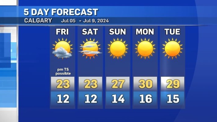
Daytime conditions are expected to remain mild in Calgary on Friday, but once again - a shortwave trough has the potential to aid in the development of showers and thunderstorms later in the evening.
If thunderstorms develop Friday night the greatest threats include small to medium-sized hail, localized heavy rain, and stronger winds.
After Friday, the driving influence for weather in central and southern Alberta will be a dominant ridge of high pressure that originates in the southwestern United States and extends north to the western Territories.
Rather than follow the typical flow in the upper patterns where high and low pressure systems circle the globe along various jets, this ridge is expected to stall out due to a blocking pattern with anchoring low pressure systems holding that high in place.
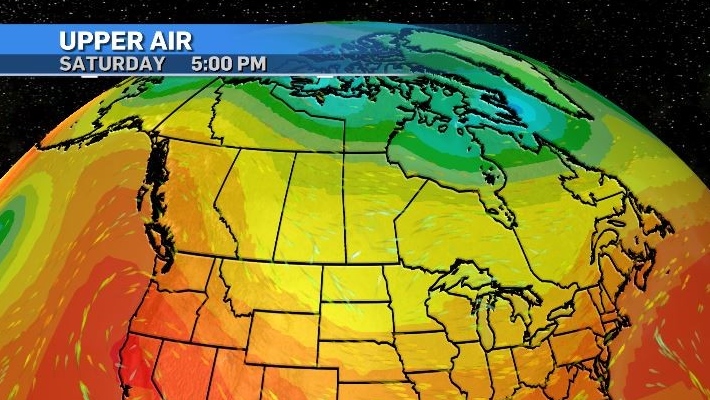
Widespread heat warnings are likely by the end of the weekend as daytime highs in portions of British Columbia are expected to reach maximums near 40 C, and peak in the mid-to-high thirties in Alberta by the middle of next week.
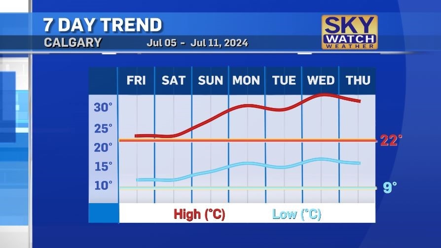
Calgary’s daytime highs will range from 27 C to 34 C from Sunday to Thursday, with respective overnight lows of 14 C to 17 C.
Heat warnings are issued by Environment and Climate Change Canada for most of Alberta (excluding Pincher Creek, Cardston, Lethbridge and Medicine Hat) when daytime highs reach at least 29 C with lows of at least 14 C for at least two consecutive days.


CTVNews.ca Top Stories

Alice Munro's daughter says mom kept silent when stepfather sexually abused her
The youngest daughter of celebrated Canadian author Alice Munro has opened up about sexual abuse by her stepfather and the deep hurt she felt when her mother chose to support her husband instead of her child.
France election: Leftists win more seats over far right, but leaves hung parliament
A coalition of the French left won the most seats in high-stakes legislative elections Sunday, beating back a far-right surge but failing to win a majority.
Bus crashes into electrical pylon, causing massive power outage on the South Shore
Tens of thousands of households on Montreal's South Shore have been without electricity since Saturday night after a bus crashed into an electrical pylon.
Ottawa councillor, residents condemn arrival of 'hateful' group Diagolon 'Terror Tour'
A community group and an Ottawa city councillor have come forward to condemn the arrival of the far-right group Diagolon after it brought its 'Road Rage Terror Tour' to Ottawa over the weekend.
Planning a last-minute summer vacation? Here's how to save money
Summer is already in full swing, but there is still time to plan a vacation — and even save some money, while you're at it.
'Meltdown': A week later, WestJet continues to feel the fallout from mechanics strike
One week after it ended, WestJet continues to feel the effects of a mechanics strike that nearly shut down the airline's network for 29 hours.
ANALYSIS
ANALYSIS Why are Trudeau and Singh avoiding Stampede this year?
This year, only Conservative leader Pierre Poilievre will be saddling up for the event, while both Prime Minister Justin Trudeau and NDP leader Jagmeet Singh will stay away.
As Biden continues campaigning, some House Democrat leaders say he should step aside
Some leading congressional Democrats privately suggested it was time for U.S. President Joe Biden to abandon his reelection bid.
Woman dies at Rolling Stones concert in Vancouver
A woman attending the Rolling Stones concert at BC Place died Friday night, police confirmed.
Shopping Trends
The Shopping Trends team is independent of the journalists at CTV News. We may earn a commission when you use our links to shop. Read about us.


Edmonton
-

Police search for man accused of violently attacking sex workers in Edmonton: EPS
Two sex workers were violently assaulted in Edmonton and police believe the same man may have attacked more women.
-
5-year-old boy killed in Grande Prairie, Alta. crash: RCMP
A five-year-old boy from Clairmont, Alta., was killed in a five-vehicle crash in Grande Prairie, Alta., on Saturday afternoon.
-
What you need to know to stay safe outside as temperatures rise
CTV News Edmonton's Josh Classen expects temperatures next week in Edmonton to top 30 C for four or five consecutive days over the next 10 days.
Lethbridge
-

2024 Southern Alberta Summer Games kick off in Coaldale
Nearly 2,000 athletes will compete in 20 events over four days during the 2024 Southern Alberta Sumer Games. After months of planning, organizers are thrilled to welcome families from all over southern Alberta to Coaldale, Alta.
-
Court hears accused in Coutts blockade thought protest could lead to 'war'
One of two men accused of conspiring to kill Mounties at the border blockade at Coutts, Alta., characterized the protest as a last stand and told his mother there “will be a war” if police moved in.
-
Fire ban ended for Lethbridge area
With the recent moisture and cooler temperatures, fire bans and restrictions in the Lethbridge area are no longer in effect.
Vancouver
-

B.C. ship and dock foremen ordered to rescind strike notice
A 72-hour strike notice served by members of the union representing ship and dock foremen in B.C. violated Canada’s labour code and must be rescinded, a federal tribunal ruled Sunday.
-
17 temperature records broken amid B.C. heat wave
Sunday was the hottest July 7 on record in 17 communities across B.C. amid a heat wave that prompted weather warnings in much of the province, according to preliminary data from Environment and Climate Change Canada.
-
Man faces several charges after 'crime spree' in Langley: RCMP
A Surrey man is facing several charges after he went on a “crime spree” in Langley on Friday, according to local Mounties.
Vancouver Island
-
B.C. ship and dock foremen ordered to rescind strike notice
A 72-hour strike notice served by members of the union representing ship and dock foremen in B.C. violated Canada’s labour code and must be rescinded, a federal tribunal ruled Sunday.
-
17 temperature records broken amid B.C. heat wave
Sunday was the hottest July 7 on record in 17 communities across B.C. amid a heat wave that prompted weather warnings in much of the province, according to preliminary data from Environment and Climate Change Canada.
-
B.C. heat wave expected to last until at least Tuesday night: ECCC
Heat warnings for Metro Vancouver and the Fraser Valley are expected to remain in effect until at least Tuesday night, according to Environment and Climate Change Canada.
Saskatoon
-

Parts of Saskatchewan under extreme heat warning
Environment Canada has issued extreme heat warnings for parts of Saskatchewan with temperature forecasts predicting highs reaching 35 C in some areas.
-
Body of Sask. teen recovered after canoe overturns on Helene Lake
A Sask. teen boy reported missing on Wednesday after a canoe overturned on Helene Lake has been found dead.
-
This vintage steam engine will be making a stop in Saskatchewan
Moose Jaw will be host to a piece of railroad history on Monday, as CPKC celebrates its "final spike tour" with a cross-continental journey from its famed 2816 locomotive "The Empress."
Regina
-

Minor injuries reported after three vehicle crash in south Regina
A collision between three vehicles disrupted travel plans for those in Regina's south end on Saturday.
-
This vintage steam engine will be making a stop in Saskatchewan
Moose Jaw will be host to a piece of railroad history on Monday, as CPKC celebrates its "final spike tour" with a cross-continental journey from its famed 2816 locomotive "The Empress."
-
Parts of Saskatchewan under extreme heat warning
Environment Canada has issued extreme heat warnings for parts of Saskatchewan with temperature forecasts predicting highs reaching 35 C in some areas.
Toronto
-

Victim critical after being found shot in Leslieville, 1 suspect outstanding
One person is fighting for their life in hospital after being found with gunshot wounds inside an apartment building in Toronto's east end on Sunday afternoon.
-
'Heat event' coming to much of southwestern Ontario early this week
It’s going to be a hot start to the week in much of southwestern Ontario. On Sunday afternoon, Environment Canada issued a heat warning for several regions, including Toronto, Hamilton, Burlington-Oakville, Halton Hills-Milton, Mississauga-Brampton, Pickering-Oshawa-Southern Durham, St. Catharines-Grimsby-Northern Niagara, and Vaughan-Richmond Hill, and Markham.
-
Motorcyclist in life-threatening condition following Mississauga crash
A motorcyclist has been critically injured in a collision in Mississauga.
Montreal
-

Bus crashes into electrical pylon, causing massive power outage on the South Shore
Tens of thousands of households on Montreal's South Shore have been without electricity since Saturday night after a bus crashed into an electrical pylon.
-
Toronto woman's Jeep stolen while parked outside Montreal East hotel
The Quality Hotel & Suites Montreal East has a parking lot right outside the main entrance, so Vanessa Sabatini parked her red Jeep there overnight, assuming it would be safe.
-
Montreal failed to address school flushing sewage into river for years
A Montreal elementary school has been inadvertently flushing raw sewage into a nearby river for years, and the city, despite identifying the problem in 2021, is only now taking action to fix it.
Atlantic
-

Cavendish Beach Music Festival continues rain or shine
The largest multi-day outdoor music festival in Atlantic Canada has officially kicked-off, with some of the biggest names in country music visiting our region.
-
Man flees from traffic stop then crashes, SiRT investigating: N.S. RCMP
The Serious Incident Response Team is investigating after a man allegedly fled a traffic stop in Middle Sackville, N.S., resulting in a crash which led to serious injuries on Saturday.
-
Halifax sizzles with excitement at first-ever hot dog eating contest
The aroma of sizzling hot dogs filled the air in Halifax, as the owners of the Halifax Beer Garden in downtown hosted the first-ever hot dog eating contest in the city.
Winnipeg
-

Weapons, assault charges laid against Brandon teens in separate incidents
Brandon police were busy this weekend, arresting and charging three teenaged boys in two separate incidents.
-
Thousands without power near Lac du Bonnet
More than 2,500 customers are without power near Lac du Bonnet, Man., and it’s not clear when it will be restored.
-
93-year-old steam train chugs into Winnipeg rail yard
The CPKC Final Spike Steam Tour rolled through Winnipeg Saturday, wrapping up its three-country, cross-continental journey.
Ottawa
-

Ottawa councillor, residents condemn arrival of 'hateful' group Diagolon 'Terror Tour'
A community group and an Ottawa city councillor have come forward to condemn the arrival of the far-right group Diagolon after it brought its 'Road Rage Terror Tour' to Ottawa over the weekend.
-
Woman dead after being pulled from water in Prince Edward County
Ontario Provincial Police are investigating after a woman was pulled from the water and died in Prince Edward County on Saturday.
-
Children's Aid Society workers in Ottawa set to walk off the job starting Monday
Children's Aid Society of Ottawa workers are set to strike Monday morning after bargaining between officials and the Ontario Public Service Employees Union broke down on Saturday.
Northern Ontario
-

Three people displaced by Greater Sudbury barbecue fire
Three people have been displaced by a weekend fire in the area of Nickel Street and 6th Avenue in the Greater Sudbury community of Levack.
-
Novice driver charged with stunted driving, fleeing police on Hwy. 11 while allegedly impaired
A 31-year-old man from Milford Bay is facing multiple charges following a traffic stop last week.
-
OPP investigating suspicious death in Blind River
Ontario Provincial Police are investigating a suspicious death in Blind River on Saturday.
Barrie
-

Bruce Cockburn inducted into Mariposa Hall of Fame
The Mariposa Folk Festival concluded in Orillia Sunday evening, highlighted by Bruce Cockburn's headline performance and induction into the Mariposa Hall of Fame.
-
LCBO workers protest in Collingwood
More than a dozen LCBO workers gathered in front of the closed Collingwood store on First Street as the strike reached its third day.
-
Muslim community leader speaks on gender identity
The third day of Canada's largest Muslim Convention in Bradford was highlighted by a lecture on the relationship between Islam and gender identity.
Kitchener
-

Most-read stories of the week: Hogweed, WWE superstar surprise, firework chaos
Hogweed popping up in the area, a surprise from a WWE superstar, and Canada Day firework chaos round out the most-read stories of the week.
-
Motorcyclist dies after crash south of Hagersville
A motorcyclist has died following a collision in Haldimand County.
-
Guelph Ont. Cargill employees to return to work Monday
960 unionized employees at Cargill Dunlop ratified a new collective agreement Saturday afternoon.
London
-

‘Perfect weather, iconic bands, record crowds’; 30th Sunfest is big hit
It was a dream way to celebrate 30 years of Sunfest in downtown London, Ont. “We couldn't be happier,” says Mercedes Caxaj, Sunfest artistic director.
-
Berth in Canadian Championships on the line at Slo-Pitch Eliminations Sunday
Many of the best slo-pitch players in Canada have been battling it out over three days this weekend in Dorchester, Ont.
-
One arrested following robbery investigation in Hanover: Police
A 23-year-old man has been arrested following a robbery investigation, according to Hanover police.
Windsor
-

Body art culture and 'freedom of expression' on display at Windsor's first tattoo expo
An organizer of Windsor's first tattoo expo hopes the event will help dispel the negative stigma some people have about body art.
-
VIDEO
VIDEO Local pizza maker nominated for world's 100 best wants Windsor 'at the table' with New York and Chicago pizza
After earning awards for Canada's best pizza chef in Canada and top-five positions in competitions across North America, Dean Litster is in the running to be recognized on an international stage.
-
Harrow family of four died from gunshot wounds in case of intimate partner violence, Ontario police say
Investigators have determined that the deaths of four family members in Harrow in June were the result of intimate partner violence, with three dying from gunshot wounds and one from a self-inflicted gunshot wound.


