Severe storms possible for overnight
AFTERNOON UPDATE: Storms are now active across the region:
Carrying into the later afternoon, storms will likely intensify beyond the warning-relayed nickel-sized hail. Calgary, too, despite being in the development zone, could see a storm manifest over part of the city. Hail would be the major threat, were this to occur.
Rainfall totals are steady for Calgary, with around 20 milimetres likely by Friday afternoon; the longer-range forecast now shows the tail of our sunnier period, with showers on the way Tuesday.
MORNING EDITION: Today offers dangerous conditions in parts of our province.
The lee low coming down from the Rockies west of Red Deer will make a sweeping advance across the prairies, clipping at a good pace into Saskatchewan by this evening. Along the way, it’ll scoop up everything it needs to generate severe storms and, similar to yesterday, supercells along a similar corridor.
The noteworthy adjustment will be in these storms maturing to potential tornado development. Tornado watches in Central to East-Central Alberta aren’t out of the question, nor would warnings be.
Hail sizes in the severe thunderstorm warnings yesterday hit ping pong to golf ball sized – this is solely from the warning status! I didn’t see photographs floating about. Regardless, conditions are similar today. Two to four centimetres of hail is possible in supercell regions, along with warning-level (90+ km/h) wind gusts.
Added to this, I mentioned Central Alberta could see heavy rain yesterday – that’s now on the books, with 40 to 60 milimetres expected:
More is possible in isolated regions; a few spots will likely crest 70 milimetres.
For all of this, I have yet to speak of Calgary! Storm-wise, our city is once again in the development zone; storm energy will roll free of the foothills and traverse eastward, from which we may see isolated thundershowers. Rainfall-wise, showers build this morning, then (coupled with storms) from the mid-afternoon to the evening. 10 to 20 milimetres remains the standard, with the majority of showers wrapping up by noon tomorrow. Thereafter, we rise into high pressure and sunshine for the weekend.
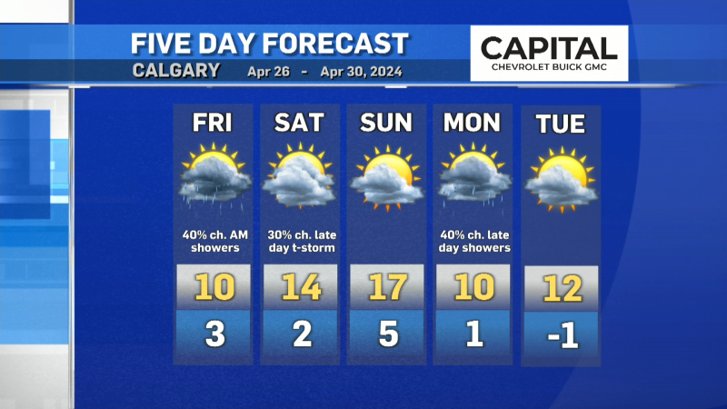
Your five day forecast:
Thursday
- Evening: showers, low 6 C
Friday
- Cloudy, morning showers
- Daytime high: 15 C
- Evening: clear, low 6 C
Saturday
- Sunny
- Daytime high: 19 C
- Evening: clear, low 9 C
Sunday
- Sunny
- Daytime high: 24 C
- Evening: clear, low 10 C
Monday
- Mainly sunny, risk of pm showers
- Daytime high: 24 C
- Evening: scattered showers, low 12 C
Tuesday
- Mainly cloudy, showers
- Daytime high: 19 C
- Evening: scattered showers, low 9 C
Our pics of the day are from Tracy in Oyen of yesterday’s storms!
Submit your weather photos here to see them featured in our article, and perhaps even as the pic of the day during our news at six! You can also share my way on Twitter, or to our Instagram at @CTVCalgaryWeather.
CTVNews.ca Top Stories
B.C. tenants evicted for landlord's use after refusing large rent increase to take over neighbouring suite
Ashley Dickey and her mother rented part of the same Coquitlam duplex in three different decades under three different landlords.
Mountain guide dies after falling into a crevasse in Banff National Park
A man who fell into a crevasse while leading a backcountry ski group deep in the Canadian Rockies has died.
Expert warns of food consumption habits amid rising prices
A new survey by Dalhousie University's Agri-Food Analytics Lab asked Canadians about their food consumption habits amid rising prices.
MPP Sarah Jama asked to leave Ontario legislature for wearing keffiyeh
MPP Sarah Jama was asked to leave the Legislative Assembly of Ontario by House Speaker Ted Arnott on Thursday for wearing a keffiyeh, a garment which has been banned at Queen’s Park.
Charlie Woods, son of Tiger, shoots 81 in U.S. Open qualifier
Charlie Woods failed to advance in a U.S. Open local qualifying event Thursday, shooting a 9-over 81 at Legacy Golf & Tennis Club.
Ex-tabloid publisher testifies he scooped up possibly damaging tales to shield his old friend Trump
As Donald Trump was running for president in 2016, his old friend at the National Enquirer was scooping up potentially damaging stories about the candidate and paying out tens of thousands of dollars to keep them from the public eye.
Here's why provinces aren't following Saskatchewan's lead on the carbon tax home heating fight
After Prime Minister Justin Trudeau said the federal government would still send Canada Carbon Rebate cheques to Saskatchewan residents, despite Saskatchewan Premier Scott Moe's decision to stop collecting the carbon tax on natural gas or home heating, questions were raised about whether other provinces would follow suit. CTV News reached out across the country and here's what we found out.
Montreal actress calls Weinstein ruling 'discouraging' but not surprising
A Montreal actress, who has previously detailed incidents she had with disgraced Hollywood producer Harvey Weinstein, says a New York Court of Appeals decision overturning his 2020 rape conviction is 'discouraging' but not surprising.
Caleb Williams, Jayden Daniels and Drake Maye make it four NFL drafts with quarterbacks going 1-3
Caleb Williams is heading to the Windy City, aiming to become the franchise quarterback Chicago has sought for decades.


