Snow this morning, wind this afternoon for Calgary
CALGARY -
Your bottom line up front: Avoid travel where you can.
Damaging wind is possible south of Calgary. Heavy snow is possible north of us. Calgary's full Stealers Wheel, with some snow, some wind, and parameters aligned for no watch, warning, or statement at this time.
Here we go:
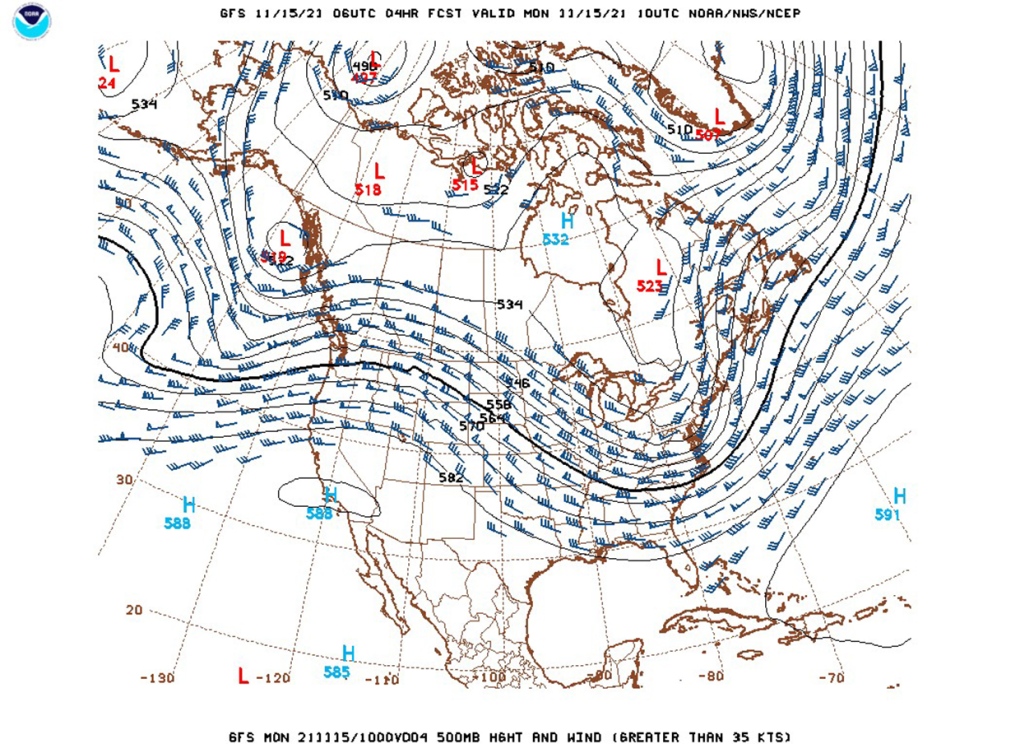
The jet is south of us. We're in a zone where Pacific moisture is hurtling off the foothills, which paints this picture of warnings for BC:
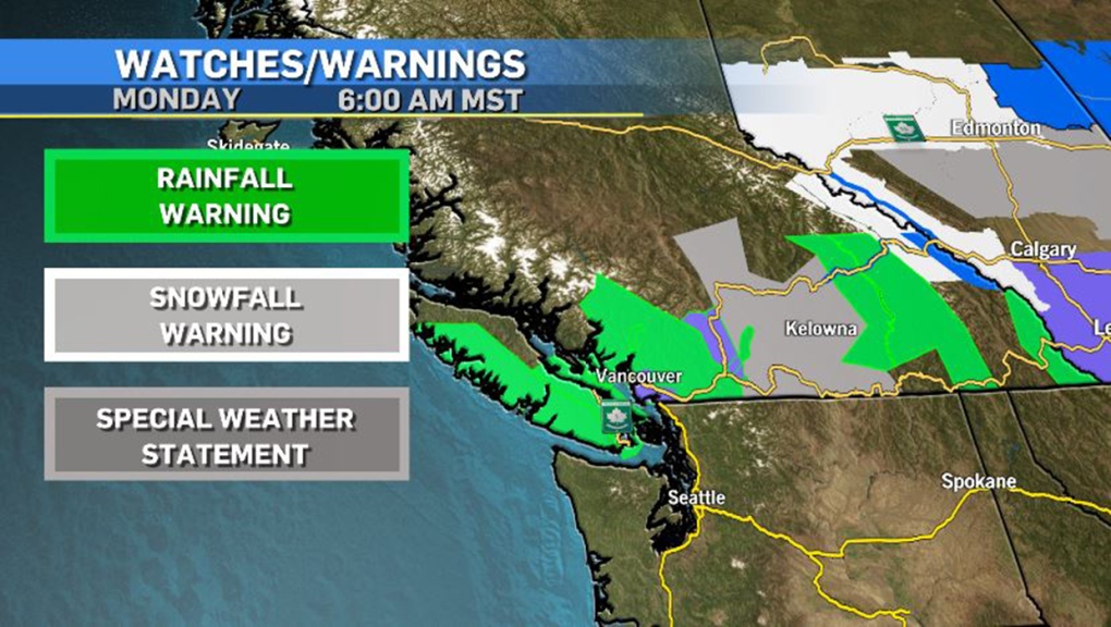
Extraordinarily heavy rain has generated terrible conditions, including evacuation orders:
On our side of the boundary, we get this picture:
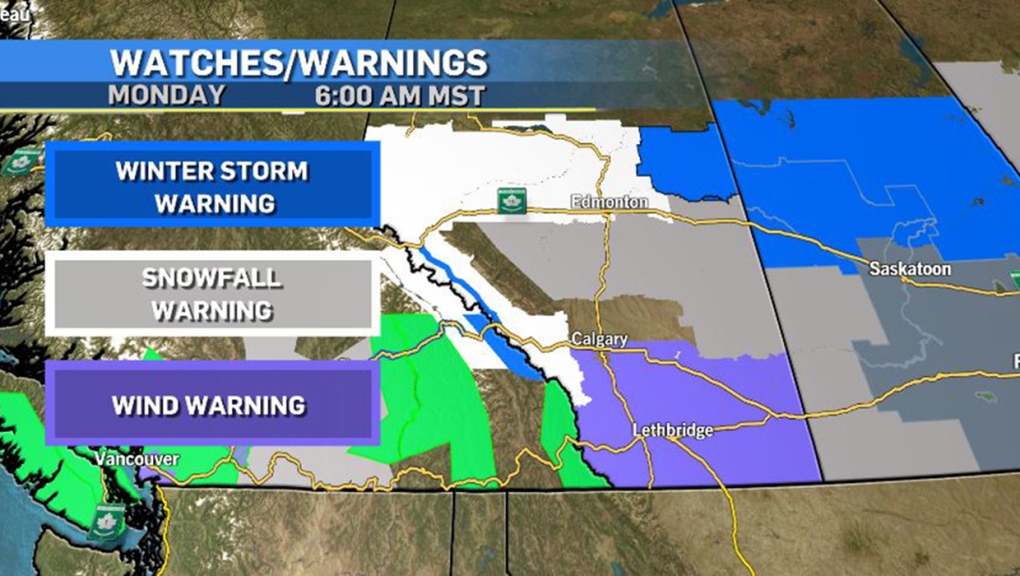
Moisture shoves across the boundary, with portions of the mountain parks cranking the dial into the 30 to 40 centimetre range along Highway 93 from Jasper straight down to Lake Louise. This adds to snow that began yesterday. Upward of 60 cm may result from this band.
Let's talk diminishing returns.
As this band pushes off the southern foothills, snowfall amounts will drop off drastically. Calgary's initial estimates of five to 10 cm have fallen off, assisted by milder temperatures and a slight adjustment to the formation zone of the Clipper. We'll still see a range of two to five cm, but this afternoon that changes to melting weather; the southern foothills are completely inundated by wind warnings as the Clipper rapidly plunges our pressure, which will lead off the foothills with 110 km/h gust potential, before "dying down" to 100 km/h. This will happen into the afternoon as the low forms. Calgary is too far north for this warning (so is Okotoks), but we may top the 60 km/h marker here. So, morning snow, afternoon chinook, overnight snow. Sure. Why not.
North along the QEII Highway snow builds up yet again, with 10 to 20 cm possible through the northern face of the forming Clipper, and special weather statements are in effect for Drayton Valley, where temperatures will hit a range for potential freezing rain this afternoon. Snowfall to the west of Calgary will top the 10 cm marker in higher elevations.
As with all Alberta Clippers, it then moves along rapidly. Tomorrow morning, another lick of snow may shove off the foothills, generating an additional centimetre or two (and more in the foothills) for Calgary. By dinnertime tomorrow, the system will be in Manitoba, which paints the following:
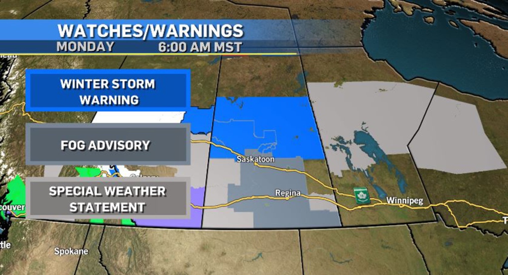
Saskatchewan's winter storm warnings are effectively copycats of last week's Clipper; an additional 20 to 35 cm is on the way. The special weather statements in Manitoba and northern Ontario will likely be replaced with snowfall warnings later today.
YOUR FIVE-DAY FORECAST
Today:
- Morning snow, then SW gusts in the 60s
- Daytime high: 7 C
- Evening: some cloud, a chance of flurries, low -2 C
Tuesday:
- Mainly cloudy, NW gusts in the 60s
- Daytime high: -1 C
- Evening: mainly clear, low -9 C
Wednesday:
- Mainly sunny
- Daytime high: 0 C
- Evening: clear, low -6 C
Thursday:
- Partly cloudy
- Daytime high: 5 C
- Evening: some cloud, low -3 C
Friday:
- Partly cloudy
- Daytime high: 3 C
- Evening: some cloud, low -6 C
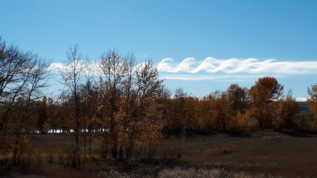
A quick pic of the day: Cathy sent this in, citing it from a few weeks ago: these are Kelvin Helmholtz waves! They're generated by differential wind shear - two layers of the atmosphere moving at different speeds through a moist layer.
You can submit your photos here, email me here, or tweet them over!


CTVNews.ca Top Stories

B.C. tenants evicted for landlord's use after refusing large rent increase to take over neighbouring suite
Ashley Dickey and her mother rented part of the same Coquitlam duplex in three different decades under three different landlords.
Mountain guide dies after falling into a crevasse in Banff National Park
A man who fell into a crevasse while leading a backcountry ski group deep in the Canadian Rockies has died.
Expert warns of food consumption habits amid rising prices
A new survey by Dalhousie University's Agri-Food Analytics Lab asked Canadians about their food consumption habits amid rising prices.
MPP Sarah Jama asked to leave Ontario legislature for wearing keffiyeh
MPP Sarah Jama was asked to leave the Legislative Assembly of Ontario by House Speaker Ted Arnott on Thursday for wearing a keffiyeh, a garment which has been banned at Queen’s Park.
Charlie Woods, son of Tiger, shoots 81 in U.S. Open qualifier
Charlie Woods failed to advance in a U.S. Open local qualifying event Thursday, shooting a 9-over 81 at Legacy Golf & Tennis Club.
Ex-tabloid publisher testifies he scooped up possibly damaging tales to shield his old friend Trump
As Donald Trump was running for president in 2016, his old friend at the National Enquirer was scooping up potentially damaging stories about the candidate and paying out tens of thousands of dollars to keep them from the public eye.
Here's why provinces aren't following Saskatchewan's lead on the carbon tax home heating fight
After Prime Minister Justin Trudeau said the federal government would still send Canada Carbon Rebate cheques to Saskatchewan residents, despite Saskatchewan Premier Scott Moe's decision to stop collecting the carbon tax on natural gas or home heating, questions were raised about whether other provinces would follow suit. CTV News reached out across the country and here's what we found out.
Montreal actress calls Weinstein ruling 'discouraging' but not surprising
A Montreal actress, who has previously detailed incidents she had with disgraced Hollywood producer Harvey Weinstein, says a New York Court of Appeals decision overturning his 2020 rape conviction is 'discouraging' but not surprising.
Caleb Williams, Jayden Daniels and Drake Maye make it four NFL drafts with quarterbacks going 1-3
Caleb Williams is heading to the Windy City, aiming to become the franchise quarterback Chicago has sought for decades.
Shopping Trends
The Shopping Trends team is independent of the journalists at CTV News. We may earn a commission when you use our links to shop. Read about us.


Edmonton
-

UCP able to remove councillors and axe city bylaws in new sweeping bill aimed at municipal politics
The Government of Alberta wants to change how municipalities handle elections and local politics.
-
Oilers 'far superior' to Kings when they're on top of their game: analyst
It's a travel day for the Edmonton Oilers — and some of their fans are along for the ride.
-
Experts urge Albertans to check measles vaccine status after confirmed Edmonton case
A confirmed case of measles in Edmonton has prompted another plea from health officials for people to make sure vaccinations are up to date.
Lethbridge
-

Former U of L student awarded diversity, equity and inclusion medal by NASA
A former University of Lethbridge student has been awarded the Medal for Diversity, Equity, Inclusion and Equity by NASA.
-
Oilers get hat trick from MacNeil en route to 4-1 win over Bandits
The Okotoks Oilers bounced back against the Bandits Wednesday night, defeating Brooks 4-1.
-
Fire risk for southern Alberta high: Natural Resources Canada
It’s not even May 1 and the fire risk for southern Alberta is already alarming.
Vancouver
-

Vancouver developer apologizes for housing scandal at Little Mountain
It’s arguably the biggest social housing scandal in Vancouver’s history and today the developer responsible for the Little Mountain project apologized for the multi-year delay that’s left a massive plot of land vacant during a housing crisis.
-
'So shocking': Roommate of victim left reeling after fatal White Rock stabbing
The roommate and long-time friend of the young man who was killed in White Rock Tuesday night, says he’s still in disbelief over what happened.
-
Inquest into B.C. police shooting deaths recommends emergency events be recorded
An inquest jury looking into the police shooting deaths of a man and the woman he was holding hostage has recommended that events involving the emergency response team be recorded with both video and audio.
Vancouver Island
-

Hiker airlifted to hospital in critical condition after falling into Vancouver Island canyon
A hiker was airlifted to hospital in critical condition Tuesday after he fell approximately 60 metres into a canyon on Vancouver Island.
-
B.C. civil lawsuit against Sex Pistols guitarist alleges 1980 sexual assault
A Vancouver woman has filed a civil lawsuit against Paramount Pictures Corp. and punk rocker Stephen Jones of The Sex Pistols alleging he sexually assaulted her as a teenager while she was a movie extra more than 40 years ago.
-
Harbour Air commits to buying 50 electric engines for seaplane fleet
Harbour Air is travelling towards a more sustainable future, looking to electrify its fleet of 45 aircraft.
Saskatoon
-

Crown argues for life sentence for Sask. Mountie who shot and killed his lover
A Crown prosecutor says the former RCMP officer who shot and killed his lover should be sentenced to life in prison.
-
'Difficult to maintain': Private Sask. school embroiled in abuse allegations may soon close
A private Christian school at the centre of a civil lawsuit and several criminal cases might soon be taken over by an affiliated group, according to a letter obtained by CTV News.
-
Council votes for bike safety improvements at corner where cyclist was killed
Saskatoon city council is making road safety improvements following the death of a cyclist at a busy intersection last year.
Regina
-

RCMP make 2 arrests in connection to Oxbow area homicide
Saskatchewan RCMP have made two arrests in a homicide investigation in the province's southeast.
-
'Get these doctors here': Sask. family calls on province to step up gastroenterologist recruitment
The Weber family is being forced to travel to Toronto due to a lack of pediatric gastroenterologists (GIs) in the province. The family’s situation was highlighted by Saskatchewan’s official opposition.
-
Looking ahead to the upcoming CFL Draft
The draft will take place on Tuesday, April 30, the Saskatchewan Roughriders currently hold the third overall pick.
Toronto
-
Suspect, 3 persons of interest sought after man falls to death from downtown Toronto balcony
Toronto police say the homicide unit is investigating after a man was reportedly pushed to his death from a balcony downtown late Wednesday night.
-
MPP Sarah Jama asked to leave Ontario legislature for wearing keffiyeh
MPP Sarah Jama was asked to leave the Legislative Assembly of Ontario by House Speaker Ted Arnott on Thursday for wearing a keffiyeh, a garment which has been banned at Queen’s Park.
-
Man shot and killed in violent home invasion at Etobicoke townhouse, police say
Toronto police say they are searching for three suspects after a man was shot and killed inside an Etobicoke townhouse during what investigators have described as a violent home invasion.
Montreal
-

Body of Quebec man who died in Cuba found in Russia, family confirms
A Montreal-area family confirmed to CTV News that the body of their loved one who died while on vacation in Cuba is being repatriated to Canada after it was mistakenly sent to Russia.
-
Montreal actress calls Weinstein ruling 'discouraging' but not surprising
A Montreal actress, who has previously detailed incidents she had with disgraced Hollywood producer Harvey Weinstein, says a New York Court of Appeals decision overturning his 2020 rape conviction is 'discouraging' but not surprising.
-
'There's really no justice': Quebec mother, daughter speak out after man gets house arrest for years of abuse
A mother and daughter are speaking out after a Quebec man was sentenced to house arrest for years of domestic abuse. They were both physically assaulted by the mother's ex-partner and say the offender got off with another light sentence.
Atlantic
-

'They followed their gut': N.B. RCMP say wellbeing check led to rescue of human trafficking victims
The New Brunswick RCMP say a wellbeing check that led to the rescue of three women from alleged human trafficking in Moncton earlier this month was the result of someone following their gut.
-
2 teens charged in Halifax homicide: police
Two teenagers have been charged with second-degree murder in connection to an alleged homicide near the Halifax Shopping Centre earlier this week.
-
N.S. residents arrested at New Brunswick border with multiple weapons
Canadian Border Services Agency (CBSA) officers arrested two Nova Scotia residents at the New Brunswick border after they seized multiple prohibited firearms.
Winnipeg
-

'Deep ignorance': Calls for Manitoba trustee to resign sparked after comments about Indigenous people and reconciliation
A rural Manitoba school trustee is facing calls to resign over comments he made about Indigenous people and residential schools earlier this week.
-
Former Manitoba premier Heather Stefanson leaving politics after 23 years
Former Manitoba premier Heather Stefanson is resigning her legislature seat and leaving political life.
-
Arrest made in 2021 northern Manitoba double homicide: RCMP
Manitoba RCMP have arrested a suspect in relation to a 2021 double homicide in a remote northern community.
Ottawa
-

Criminal charge laid in 2023 hedge trimming death; company owner pleads guilty to Ministry of Labour charge
The supervisor of a 20-year-old man who died after he was electrocuted while trimming hedges in Manotick in May 2023 has been charged with criminal negligence causing death. Meanwhile, the company owner has pleaded guilty to a charge laid by the Ministry of Labour.
-
Attempted murder charges laid in Renfrew, Ont. double stabbing
Two people, including a 60-year-old man, are facing charges in connection with a double stabbing in Renfrew, Ont.
-
Here is where Ottawa's newest roundabout is planned and why OC Transpo says it's needed
Love them or hate them, roundabouts are found all-around the city, but a plan to a replace an Orléans intersection with one has some residents upset.
Northern Ontario
-

Former head of Ont. tech company charged in $6M fraud case
A years-long fraud investigation by the Ontario Provincial Police’s anti-rackets branch has resulted in fraud and other charges for the former head of BioNorth Technology Group, Frank Benincasa
-
Secret $70M Lotto Max winners break their silence
During a special winner celebration near their hometown, Doug and Enid shared the story of how they discovered they were holding a Lotto Max ticket worth $70 million and how they kept this huge secret for so long.
-
Fire victims in Timmins say thieves have stolen their personal belongings
A month after an accidental fire forced more than 100 people out of their apartments at the Empire Complex in Timmins, residents are now dealing with being victims of theft.
Barrie
-

One person charged following shootings in Bradford
One person has been charged following a series of shootings in August and September in Bradford West Gwillimbury.
-
Honda unveils $15B investment plan to build new EV plant in Alliston
Prime Minister Justin Trudeau and Premier Doug Ford visited Alliston on Thursday to unveil a $15 billion investment in an electric vehicle and battery facility.
-
Highschool students compete in mock trial at Barrie courthouse
A group of teens entered the Barrie courtroom on Thursday and participated in a mock trial competition.
Kitchener
-

Generational farm could be impacted if Wilmot land assembly goes ahead
A family of farmers say their operations would be significantly impacted if the Region of Waterloo goes ahead with a land assembly project in the Wilmot Township area.
-
Former Kitchener doctor accused of sexually assaulting patients makes brief court appearance as marathon trial continues
The trial for former neurologist Jeffrey (Scott) Sloka began two and a half years ago, and it remains unclear when there may be a verdict.
-
Drivers who got bad fuel from Guelph, Ont. gas station receiving compensation
Drivers who were hit with hefty repair bills after fueling up at a Guelph gas station appear to be finally getting their money back.
London
-

Aamjiwnaang First Nation declares state of emergency over benzene levels
On Thursday, Aamjiwnaang First Nation Chief Chris Plain declared a state of emergency due to the high levels of benzene.
-
Laid off workers seeking severance say 'Shame on Wescast'
A crowd of former Wescast employees and supporters rallied outside Wescast Industries in Wingham, Ont. on Thursday, requesting the severance pay they're owed.
-
LHSC performs a Canadian first in robot-assisted direct lateral spine surgery
Spine surgery may never be the same for people with chronic back pain and other physical ailments.
Windsor
-

'A slap in the face': Foreign workers still building NextStar battery plant in Windsor: CBTU
Canada’s Building Trades Unions is demanding the federal government intervene as it alleges local workers are being “sidelined” by foreign employees.
-
Oversized danger: pedestrian advocacy groups call for smaller trucks and SUVs
A coalition of 60 pedestrian and cycling safety advocacy groups is calling for government regulation and auto industry changes after data showed the dangers caused by large trucks and SUVs towards pedestrians.
-
Car theft suspect sought on Tecumseh Road
Windsor police are asking for the public's help identifying a suspect after a car theft on Tecumseh Road.


