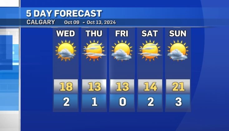
Temperatures dropping for start of the Thanksgiving weekend
A shift in weather patterns will align with a cool down for the west over the next couple of days.
Daytime highs on Wednesday will be a few degrees colder than the past few days with a second drop of around 5 C by Thursday.
The main weather maker for the start of the week was a ridge of high pressure that had stalled out in the upper levels, but that ridge has already started to track east and will continue to do so throughout the day Wednesday.
Behind it, cooler air will sink south toward the southern border of Alberta, B.C. and Saskatchewan, bringing both daytime highs and overnight lows closer to a seasonal range for Thursday, Friday and Saturday.
Rain will continue along the northern edge of that departing ridge or into areas west of the QEII and into south-central and central Alberta on Wednesday, with a slight chance of rain for the Calgary area later in the day.
It will also be windy in the southern corner of the province, but not quite as windy as it was on Monday and Tuesday.
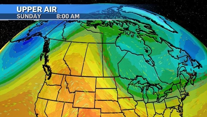
The end of this long weekend will be much warmer than the start when another ridge of high pressure moves in from the Pacific Coast and pushes as far north at the Yukon and Northwest Territories.
Conditions should be mostly consistent with more sunshine than cloud over the next five days.


CTVNews.ca Top Stories

From essential goods to common stocking stuffers, Trudeau offering Canadians temporary tax relief
Canadians will soon receive a temporary tax break on several items, along with a one-time $250 rebate, Prime Minister Justin Trudeau announced Thursday.
She thought her children just had a cough or fever. A mother shares sons' experience with walking pneumonia
A mother shares with CTVNews.ca her family's health scare as medical experts say cases of the disease and other respiratory illnesses have surged, filling up emergency departments nationwide.
Trump chooses Pam Bondi for attorney general pick after Gaetz withdraws
U.S. president-elect Donald Trump on Thursday named Pam Bondi, the former attorney general of Florida, to be U.S. attorney general just hours after his other choice, Matt Gaetz, withdrew his name from consideration.
Putin says Russia attacked Ukraine with a new missile that he claims the West can't stop
Russian President Vladimir Putin announced Thursday that Moscow has tested a new intermediate-range missile in a strike on Ukraine, and he warned that it could use the weapon against countries that have allowed Kyiv to use their missiles to strike Russia.
A one-of-a-kind Royal Canadian Mint coin sells for more than $1.5M
A rare one-of-a-kind pure gold coin from the Royal Canadian Mint has sold for more than $1.5 million. The 99.99 per cent pure gold coin, named 'The Dance Screen (The Scream Too),' weighs a whopping 10 kilograms and surpassed the previous record for a coin offered at an auction in Canada.
Here's a list of items that will be GST/HST-free over the holidays
Canadians won't have to pay GST on a selection of items this holiday season, the prime minister vowed on Thursday.
Video shows octopus 'hanging on for dear life' during bomb cyclone off B.C. coast
Humans weren’t the only ones who struggled through the bomb cyclone that formed off the B.C. coast this week, bringing intense winds and choppy seas.
Taylor Swift's motorcade spotted along Toronto's Gardiner Expressway
Taylor Swift is officially back in Toronto for round two. The popstar princess's motorcade was seen driving along the Gardiner Expressway on Thursday afternoon, making its way to the downtown core ahead of night four of ‘The Eras Tour’ at the Rogers Centre.
Service Canada holding back 85K passports amid Canada Post mail strike
Approximately 85,000 new passports are being held back by Service Canada, which stopped mailing them out a week before the nationwide Canada Post strike.
Shopping Trends
The Shopping Trends team is independent of the journalists at CTV News. We may earn a commission when you use our links to shop. Read about us.


Edmonton
-

Alberta pitches new rules for auto insurance, including rate hikes, no-fault claims
The Alberta government is making changes to auto insurance, including rate hikes and switching to a predominantly no-fault claims model.
-
Edmonton police chief coy on future plans as he gets ready for early departure
Edmonton's top cop wouldn't detail what his plans are following his retirement in three months when asked Thursday at a news conference. But there are possibilities Dale McFee will be doing something else after he leaves the Edmonton Police Service on Feb. 21.
-
Cartmell, Caterina running to be Edmonton's next mayor
Two city councillors, one sitting and one former, will be running for mayor in 2025.
Lethbridge
-

Hurricanes kick off U.S. road trip with a loss, falling 4-0 to Silvertips
The Hurricanes launched a three-game road trip south of the border Wednesday dropping a 4-0 game to the league-best Everett Silvertips.
-
Lethbridge residents asked to show some love to downtown businesses during holidays
A new citywide campaign is hoping to encourage residents to shop, eat and explore local this holiday season.
-
Lethbridge career exploration day aims to get women more involved in agriculture
Agriculture is an industry mainly dominated by men, but around 80 middle school and high school students – all of whom are female – are hoping to change that.
Vancouver
-

Vancouver youth soccer coach says racism complaint went uninvestigated for a year
The coach of a soccer team in the Vancouver Youth Soccer Association claims a complaint about racism directed at 13-year-old players on his team went unaddressed for more than a year.
-
Surrey tree lighting, Coquitlam lights and lots of holiday markets happening in Metro Vancouver this weekend
Don't look now, but Christmas is less than five weeks away, and holiday festivities are ramping up across Metro Vancouver. Here are some events to check out this weekend.
-
B.C. man sentenced to probation for social media stunt
A man who drove a car into B.C.'s Burrard Inlet in a livestreamed social media stunt has been sentenced to one year of probation and will not have a criminal record if he complies with court-ordered conditions.
Vancouver Island
-

Major crime investigators reviewing death of Victoria teen, which coroner reclassified as homicide
Vancouver Island’s major crime unit is investigating the case of a Victoria teenager whose death was initially ruled an accidental overdose, but has since been reclassified by coroners as a homicide.
-
1 dead after Nanaimo house fire, RCMP say
One person is dead after a fire that destroyed a home in Nanaimo's south end Wednesday morning.
-
Another windstorm headed to B.C.’s South Coast Friday, Environment Canada says
Another fall storm is forecast to bring high winds to B.C.’s South Coast on Friday, Environment Canada says.
Saskatoon
-

Saskatoon's first female mayor sworn in
After being sworn in Wednesday night alongside a mix of new and returning city councillors, Cynthia Block becomes the first female mayor of Saskatoon.
-
Sask. tuxedo business closes stores across the province
A Saskatchewan tuxedo business says struggles with inflation and operating costs have caused it close stores across the province.
-
Alberta non-profit Mustard Seed to run Saskatoon's Lighthouse
Alberta-based non-profit the Mustard Seed is stepping up to run Saskatoon's Lighthouse.
Regina
-

Accused of sexual assault, Regina chiropractor takes the stand as first defense witness
A Regina chiropractor accused of sexually assaulting seven different women took the stand Thursday as arguments began in his defense.
-
Contractor fatally injured while on the job at Regina's Evraz plant
Evraz North America says an investigation is underway after a contractor was fatally injured while on the job in Regina on Nov. 19.
-
'I'll always be a Pat': Regina Pats trade captain Tanner Howe to Calgary
The Regina Pats have announced a blockbuster trade Thursday that sees captain Tanner Howe on his way to Calgary to play for the Hitmen as the team continues rebuilding for the future.
Toronto
-

North York shooting sends man to hospital
A man has been rushed to the hospital following a shooting in North York Thursday night.
-
Mother of three struck and critically injured by vehicle in Etobicoke dies in hospital
A 39-year-old woman who was critically injured after she and her family were struck by the driver of a vehicle in Etobicoke last month has died in hospital, Toronto police say.
-
Taylor Swift's motorcade spotted along Toronto's Gardiner Expressway
Taylor Swift is officially back in Toronto for round two. The popstar princess's motorcade was seen driving along the Gardiner Expressway on Thursday afternoon, making its way to the downtown core ahead of night four of ‘The Eras Tour’ at the Rogers Centre.
Montreal
-

Montreal says no to water fluoridation
Lachine Mayor and member of Projet Montreal Maja Vodanovic said the city will not reopen the debate on water fluoridation.
-
Pro-Palestinian protesters gathered outside Concordia University amid Quebec-wide boycotts
The lobby of Concordia University’s Hall Building was flooded with pro-Palestinian protesters Thursday as others gathered and chanted outside the campus as part of Quebec-wide solidarity strikes.
-
Transit and taxes: mixed reactions to Quebec budget
There was a mixed reaction to the Quebec government's fall fiscal update on Thursday as the province announced billions of dollars in new spending.
Atlantic
-

CTV News Roundtable: N.S. leaders discuss solutions on affordability, housing, health care
Nova Scotia’s top three political party leaders took part in CTV Atlantic’s roundtable discussion on Thursday, where they sparred over affordability, housing, health care, and campaign promises.
-
From essential goods to common stocking stuffers, Trudeau offering Canadians temporary tax relief
Canadians will soon receive a temporary tax break on several items, along with a one-time $250 rebate, Prime Minister Justin Trudeau announced Thursday.
-
'This is cold': P.E.I. mother upset over decision to remove late daughter's photos from school memorial wall
A high school on Prince Edward Island is removing pictures of its late students from a memorial wall – a decision that has upset one mother whose daughter attended the school.
Winnipeg
-

Sio Silica plans to try again with controversial project in Manitoba
Sio Silica is planning to try again with a controversial mining project in the same spot using the same method that the province rejected less than a year ago, but this time with more community engagement.
-
'We need new revenue': Winnipeg projecting operating shortfall by end of 2024
The City of Winnipeg is projecting an operating shortfall in 2024, and the plan to cover it off would completely drain the city's rainy day fund.
-
Manitoba RCMP issue Canada-wide warrant for Ontario semi-driver charged in deadly crash
Manitoba RCMP have issued a Canada-wide arrest warrant for the semi-driver involved in a crash that killed an eight-year-old girl and her mother.
Ottawa
-

uOttawa to reconsider participation in U-Pass if city increases student fares, student union says
The student union at the University of Ottawa says it will consider pulling its participation from the U-Pass, which provides discounted transit fares for students, if the city goes forward with hiking student transit fees and violating the program’s contract.
-
Abdi inquest: Arresting officer feared for his safety during deadly arrest, jurors hear
A former Ottawa police officer returned to the witness stand on Monday and provided further details of the moments before the violent and deadly arrest of Abdirahman Abdi on the fourth day of a coroner's inquest into the circumstances of his death.
-
2 arrested during Greenpeace protest outside Stornoway residence in Ottawa
Two people have been arrested following a protest outside Stornoway, the official residence of Canada's leader of the Opposition.
Northern Ontario
-

Province cancels deal with Canadore College for North Bay addiction treatment centre
After years of delays, the province has pulled the plug on an addiction treatment centre in North Bay. A news release from Canadore College on Thursday confirmed the centre won’t be moving forward.
-
From essential goods to common stocking stuffers, Trudeau offering Canadians temporary tax relief
Canadians will soon receive a temporary tax break on several items, along with a one-time $250 rebate, Prime Minister Justin Trudeau announced Thursday.
-
$3M donation to help repair arena in Elliot Lake
The City of Elliot Lake said Thursday it has received a $3-million donation from Edward and Suzanne Rogers for the Centennial Arena restoration.
Barrie
-

'You can't be lazy on my watch,' Court hears audio recordings in trial of alleged traffickers
The Crown played audio recordings in a Barrie courtroom Thursday afternoon that provided a glimpse into the lives of alleged human traffickers Lauriston and Amber Maloney and the group of young women who lived and worked for them.
-
How to avoid the number one cause of lung cancer in non-smokers, according to health experts
Radon is the number one cause of lung cancer in non-smokers in Canada, according to Grey Bruce Public Health Unit.
-
Local shelter receives donated Taylor Swift tickets
Staff at the Busby Centre, a nonprofit organization that supports individuals struggling and living on the streets of Barrie, received a surprise donation on Wednesday in the form of Taylor Swift tickets.
Kitchener
-

LRT train knocked off its tracks after slamming into car
A crash between an LRT train and car shut down a busy Kitchener street for more than eight hours on Thursday.
-
FunGuyz says it's closing all 30 of its magic mushroom stores in Ontario
FunGuyz, which calls itself the biggest magic mushroom dispensary in Canada, says it's shutting down all 30 of its Ontario locations.
-
Fight between rival motorcycle gangs in Cambridge leads to five arrests, more than a dozen charges
A fight between rival outlaw motorcycle gangs has led to multiple arrests, more than a dozen charges and the seizure of 17 firearms.
London
-

London man arrested after attempting to break into a home, threatening residents
Police say that on Thursday, November 21 between the hours of 1:30 a.m., and 4:30 a.m. the suspect came and went from a residence on Conway Drive.
-
Ont. law firm seeks information on convicted Catholic priest amid active abuse lawsuit
An Ontario law firm is seeking information about the movements and activities of a Catholic priest who was convicted of sexually abusing a 12-year-old boy before he died.
-
Former London Lightning player Chad Posthumus dead at 33 after brain aneurysm
Posthumus played a stint with the London Lightning - hitting the court for 22 games in the 2015-2016 season, averaging 11 points, and 6.5 rebounds.
Windsor
-

Ont. law firm seeks information on convicted Catholic priest amid active abuse lawsuit
An Ontario law firm is seeking information about the movements and activities of a Catholic priest who was convicted of sexually abusing a 12-year-old boy before he died.
-
Sparky's Toy Drive on the hunt for a new home
They’ve been based out of the basement of Hotel Dieu Grace Healthcare for many years, rent free - however, that partnership is coming to an end.
-
Woman sought following serious assault in west Windsor
Windsor police are asking for the public’s help identifying a suspect wanted in connection to an alleged serious assault that happened this past summer.


