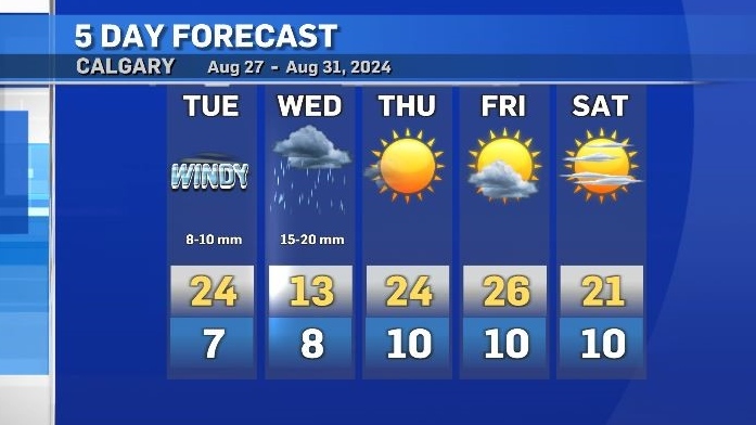
Temps to drop 10-15 C by Wednesday with strong wind and intense rain across southern Alberta

A deep upper trough in British Columbia is the main weather maker for central and southern Alberta right now.
Strong winds are expected to precede this low pressure system as it tracks across the Rockies throughout the day Tuesday and gusts of up to 80 km/h are possible.
As that low enters central Alberta, the counter clockwise rotation of the system will meet resistance from the physical barrier of the mountains, resulting in upsloping flow and heavier accumulations in areas along, and east of the foothills.
Typical of systems with an upsloping element, it is difficult to pinpoint the most vulnerable locations for maximum precipitation accumulations but there is certainty that there will be widespread rain Tuesday and Wednesday with a notable amount of moisture.
Cooler air associated with the low will drop daytime highs by as much as 15 C in some communities on Wednesday (compared to Tuesday) and overnight lows will be close to freezing in the mountains.
As a result, snow is possible in some of the higher elevation locations but any snow that falls closer to the surface in the foothills will not last.
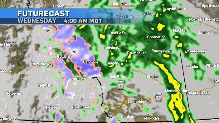
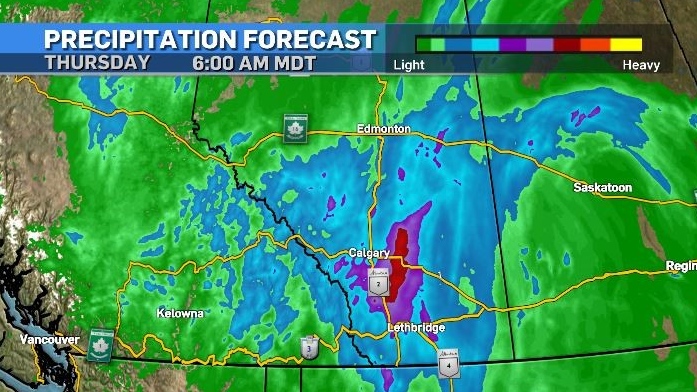
Calgary is forecast to receive at least 15 and up to 30 millimetres of rain during this event.
As quickly as conditions deteriorate, they are expected to recover just as quickly.
Thursday’s highs will bring temperatures back to what they were on Tuesday in most of southern Alberta, and the warmest temperature of the week in Calgary will happen on Friday.


CTVNews.ca Top Stories

Air Canada travellers share worries and frustrations ahead of possible pilot strike
Here's what customers had to say about their travel plans ahead of a potential Air Canada pilot strike.
Trudeau says Ukraine can strike deep into Russia with NATO arms, Putin hints at war
Prime Minister Justin Trudeau says Ukraine should be allowed to strike deep inside Russia, regardless of Moscow threatening that this would draw Canada and its allies into direct war.
Driver charged with killing NHL's Johnny Gaudreau and his brother had .087 blood-alcohol level
The driver charged with killing NHL hockey player Johnny Gaudreau and his brother Matthew as they bicycled on a rural road had a blood-alcohol level of .087, above the .08 legal limit in New Jersey, a prosecutor said Friday.
23-year-old Muskoka, Ont., resident highlights the need for rural health care after stroke
The experience of 23-year-old Muskoka, Ont., resident Robyn Penniall, who recently had a stroke, comes as concerns are being raised about the future of health care in her community.
2 suspects charged after Lamborghini stolen in armed home invasion in Richmond Hill: police
York Regional Police say they have arrested two suspects and are looking for at least one more following an armed home invasion in Richmond Hill that saw thieves escape in the victim’s Lamborghini.
Stuck-in-space astronauts make first public comments since Boeing capsule left without them
Stuck-in-space astronauts Butch Wilmore and Suni Williams said Friday they appreciated all the prayers and well wishes from strangers back home.
Former NHL enforcer Stephen Peat dies after being hit by car in B.C.
Stephen Peat, the former Washington Capitals enforcer who fought concussion issues and was homeless at times after leaving hockey, has died from injuries sustained late last month when he was struck by a car while crossing a street. He was 44.
Ontario's top court dismisses application for bail from Jacob Hoggard
Jacob Hoggard will remain behind bars while he tries to appeal his sexual assault conviction at Canada's top court, a justice with Ontario's Appeal Court ruled Friday, calling the musician's attempt unlikely to succeed.
A cat named Drifter is safe after sneaking out and getting trapped in a sewer for nearly 8 weeks
A cat aptly named Drifter is safe at home after sneaking outside and getting trapped in a sewer for nearly eight weeks.
Shopping Trends
The Shopping Trends team is independent of the journalists at CTV News. We may earn a commission when you use our links to shop. Read about us.


Edmonton
-

'Better late than never': Alberta glad B.C. premier has changed stance on carbon tax
The Government of Alberta was glad to hear that British Columbia’s premier has changed his tune on the consumer carbon tax at the provincial level.
-
Jasper state of local emergency ending; visitors asked to be respectful
Jasper is ending its local state of emergency as it gets ready to welcome back visitors and tourists.
-
Alberta town adopts new resident code of conduct to address staff safety
An Alberta town has laid out rules for how residents must treat municipal staff and the consequences if they step out of line.
Lethbridge
-
Coaldale man charged with attempted murder after Lethbridge break-and-enter
Lethbridge police say a 28-year-old man is facing charges of attempted murder following a frightening attack on a woman inside her home this week.
-
Police operation near Vauxhall, Alta., ends: RCMP
A police operation in near Vauxhall, Alta. has ended.
-
1 suspect in custody after break-in and violent assault of Lethbridge woman
A man is in police custody with charges pending in relation to a break-in and violent assault of a woman earlier this week.
Vancouver
-

Man charged with murdering his mother in Kamloops, B.C.: RCMP
More than a year after a missing Kamloops, B.C., woman’s body was found, her son has been arrested and charged with her murder, Mounties announced Friday.
-
'Right on the edge of being extinct': Environmentalists, First Nation aim to stop B.C. ski resort in owl habitat
The Cheam First Nation and the Wilderness Committee are calling on the province to enforce protections for an endangered owl as a ski resort is proposed near Chilliwack.
-
B.C. accepts change for psychiatric care after alleged attack by mentally ill man
A report into a triple stabbing at a festival in Vancouver's Chinatown last year says the man accused of the crimes had been let out of a psychiatric care facility 99 times in the year prior without incident.
Vancouver Island
-
Police investigating suspicious death in Nanaimo, B.C.
Mounties have launched a suspicious death investigation after a man was found dead Thursday in Nanaimo, B.C.
-
Canada to deploy military patrol plane, 50 personnel to Japan
Canada will send a military patrol plane and approximately 50 personnel to Japan this month to support international sanctions on North Korea following that country's recent ballistic missile tests, Defence Minister Bill Blair announced Friday.
-
Rescue operation frees humpback whale off northern B.C.
A humpback whale was so entangled in fishing gear, ropes and buoys that it took four days for a Fisheries Department crew to unravel the mess, Paul Cottrell said.
Saskatoon
-

New OSB mill construction in Prince Albert set for 2025
After years of delays and planning, a new oriented strand board (OSB) mill is coming to Prince Albert.
-
Saskatoon police called to 5 bear spray incidents in 9 hours
The Saskatoon Police Service (SPS) had a busy evening Thursday night responding to five bear spray incidents in nine hours between 8 p.m., Thursday and 5 a.m. Friday.
-
RCMP investing suspicious death after body found in Sask. home
Saskatchewan RCMP Major Crimes Unit is investigating a suspicious death on Big Island Lake Cree Territory.
Regina
-
Heavy equipment rollover near Ituna, Sask. causing delays
A heavy equipment rollover on Highway 52 near Ituna, Sask. has led to some traffic delays Friday afternoon.
-
Saskatchewan artist fundraising to help family whose son has genetic disease
A Regina based artist is using his platform to fundraise for the family of a young boy with a genetic disease.
-
Regina Pats' Whitehead becomes first CHL player to verbally commit to NCAA
Regina Pats' forward Braxton Whitehead has become the first major junior hockey player to verbally commit to playing in the Division 1 NCAA ranks after his Western Hockey League career ends.
Toronto
-

Ontario's public broadcaster under scrutiny for funding, then pulling Russian war doc
Ongoing controversy over the documentary "Russians at War" has brought scrutiny to Ontario’s public broadcaster, which has said it will not air the film it helped fund.
-
Police investigating after fight leads to shots being fired near Toronto high school
Toronto police are investigating after a fight in midtown Friday afternoon led to shots being fired, causing a school to be placed under lockdown briefly.
-
Ontario's top court dismisses application for bail from Jacob Hoggard
Jacob Hoggard will remain behind bars while he tries to appeal his sexual assault conviction at Canada's top court, a justice with Ontario's Appeal Court ruled Friday, calling the musician's attempt unlikely to succeed.
Montreal
-

Worse than the ice storm: Tropical Storm Debby was 'costliest severe weather event in Quebec's history'
The remnants of Tropical Storm Debby, which caused significant flooding in Quebec, have become the 'costliest severe weather event in Quebec's history,' surpassing the ice storm of 1998, the Insurance Bureau of Canada said Friday.
-
Former West Island baseball coach guilty of sexual assault on 13-year-old boy
Former West Island baseball coach Robert Litvack has been found guilty of sexually assaulting a minor he was hired to train.
-
Call for more Muslim professors: Quebec says anti-Islamophobia adviser must resign
The Quebec government says Canada's special representative on combating Islamophobia must resign, after she sent a letter to college and university heads recommending the hiring of more Muslim, Arab and Palestinian professors.
Atlantic
-

Missing N.S. woman believed dead; man charged with first-degree murder
Police in Nova Scotia now believe a woman reported missing earlier this month is dead, and a man has been charged in her disappearance.
-
N.S. premier to challenge federal plan to send thousands of asylum seekers to province
Nova Scotia Premier Tim Houston is pushing against a federal government proposal that would more proportionately distribute the number of asylum seekers across Canada.
-
Alcohol, speed 'significant factors' in Fredericton crash that left 3 dead in May
The Fredericton Police Force says speed and alcohol were “significant factors” in a fatal collision that killed three people, including two teenagers, in May.
Winnipeg
-

1 dead, 3 injured in Friday morning crash on Portage Avenue
One person has died and three people were injured following a crash involving a vehicle and a pedestrian at a Portage Avenue intersection Friday morning.
-
'Very surreal and just so special': Winnipegger stars in newest Apple commercial
Apple commercials typically showcase the latest and greatest gadgets from the tech giant – and one Winnipeg woman is using her appearance in a recent ad to highlight how living with a disability doesn’t slow her down.
-
Manitoba accused of ‘wasting taxpayers' money’ with electric vehicle chargers
An advocacy group says the Manitoba government has spent nearly a third of a million dollars on electric vehicle (EV) chargers in the past two years – but hasn’t tracked if the chargers are actually being used.
Ottawa
-

Somali community alarmed after police officers wiretapped, watched
Members of Ottawa's Somali community came together Thursday to denounce the Ottawa police use of wiretaps and video surveillance on five of its own Black officers of Somali decent and their family members.
-
Jason Isbell cancels CityFolk show due to illness
Ottawa's CityFolk Festival has announced that Jason Isbell and the 400 Unit have cancelled their headline appearance this weekend.
-
Yearlong criminal trial of 'Freedom Convoy' organizers comes to an end
After 45 days of evidence and legal arguments the criminal trial of 'Freedom Convoy' organizers Tamara Lich and Chris Barber is finally at an end.
Northern Ontario
-

Driver charged with killing NHL's Johnny Gaudreau and his brother had .087 blood-alcohol level
The driver charged with killing NHL hockey player Johnny Gaudreau and his brother Matthew as they bicycled on a rural road had a blood-alcohol level of .087, above the .08 legal limit in New Jersey, a prosecutor said Friday.
-
Canadian health regulators ban this common food additive. Here's what you need to know
In a move to safeguard public heath, Health Canada has officially banned the use of brominated vegetable oil (BVO) as a food additive. Here's what you need to know.
-
Police seize sawed-off shotgun, ammo, northern Ont. teen charged
A northern Ontario teen has been charged with several weapon offences after police responded to a report of a prohibited weapon at a Kapuskasing residence.
Barrie
-

Ont. police officer's spouse charged in historical sexual assault case involving a child
CTV News is learning more about disturbing allegations of sexual assault from 14 years ago in Beeton involving the husband of a Peel Regional police officer.
-
Indoor pickleball facility to open at Georgian Mall
Pickleball fever is taking over the City of Barrie, with its first state-of-the-art indoor pickleball facility in the former Sears site at Georgian Mall.
-
Loaded gun seized, 5 arrested in Collingwood police raid
Five Collingwood residents were arrested and a loaded handgun seized following an early morning police raid on Thursday.
Kitchener
-

Councillor questions approval process following 100 complaints about Cambridge event
More than 100 noise complaints were made about a recent late night event at Riverside Park in Cambridge, leading one councillor to question why it was approved in the first place.
-
Senior cyclist who died in hit-and-run in Guelph identified
Tributes to Susan Bard have been popping up online after she died in a hit-and-run crash in Guelph last week.
-
'I was scared:' Ontario woman who lost $158K in roofing scam says she was told her home might collapse
An Ontario woman who just wanted to get some gutter guards to keep leaves out of her eavestroughs said she was convinced her home was going to collapse and handed over $158,000 in a roofing scam.
London
-
 VIDEO
VIDEOVIDEO Downtown CUPE rally in support of Western workers turns tense following altercation
There were tense moments near the end of a rally supporting striking CUPE 2361 members from Western University.
-
Pedestrian in stable condition following serious Richmond Street collision
A pedestrian injured in an early morning collision on Thursday is now in stable condition after sustaining serious injuries.
-
Airshow London is expanding thanks to new federal funding
The federal government announced Airshow London will be receiving $136,000 through the Tourism Growth Program to support new attractions for 2024.
Windsor
-

Tensions rise on Walpole Island ahead of crucial leadership election
Walpole Island First Nation is grappling with unrest as its community heads into a critical election set for Sept. 21.
-
Controversial Russian war documentary cancelled at TIFF to play at WIFF
A controversial documentary that had its screenings cancelled at the Toronto International Film Festival (TIFF) will now play at the Windsor International Film Festival (WIFF).
-
First look: All-electric Dodge Chargers coming off line at Windsor Assembly Plant
Stellantis’ Windsor Assembly Plant has given a first look at the new Dodge Chargers coming off the line. It is preparing for the upcoming Dodge Charger Daytona production launch.


