Warm and dry Thursday ahead of cool and wet weekend

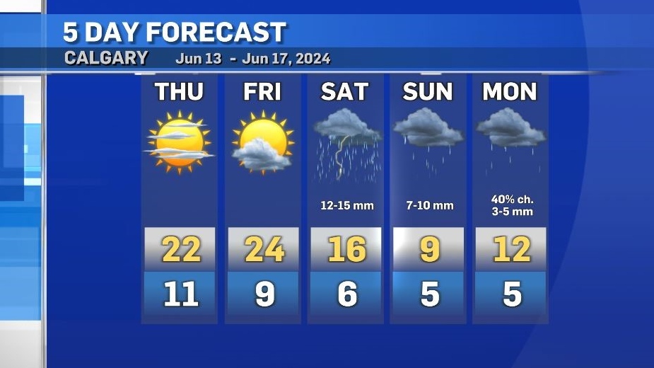
Thursday will be warm in southern Alberta as stable conditions dominate.
With a weak ridge of high pressure at the surface in southern Alberta, daytime highs are expected to range from the low to mid 20s.
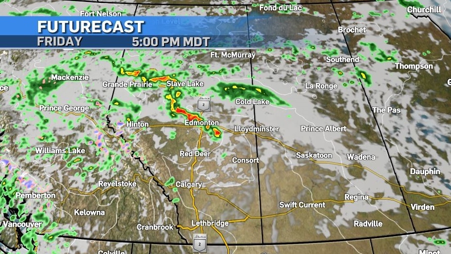
Rain is expected in northern Alberta with around five to eight millimetres possible by the end of the day.
Friday will start off warm through much of the province, with peak temperatures in southern Alberta between the mid to high 20s, however an incoming shift in weather patterns will create instability in central Alberta and convective activity (thunderstorms) will likely occur.
That cooler air mass will sink south throughout the weekend causing daytime highs in Calgary to drop 15 C from Friday to Sunday. For perspective, the daytime high on Sunday will be colder than the overnight lows at the end of this week.
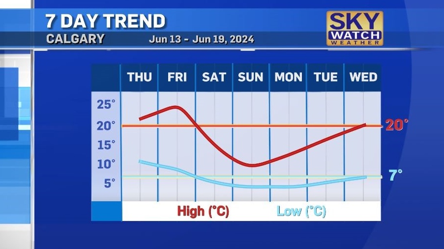
First thunderstorms and then rain will persist over the Father’s Day weekend, with the bulk of precipitation in Calgary expected on Saturday.
Warmer weather will be slow to return, with seasonal ranges not expected again until Wednesday.


CTVNews.ca Top Stories

Trudeau says Liberals 'strong and united' despite caucus dissent
Prime Minister Justin Trudeau says the Liberal party is 'strong and united,' despite efforts from within his caucus to oust him as leader.
Air Transat to lay off up to 400 flight attendants amid financial woes
Air Transat says it is laying off as many as 400 flight attendants, but plans to bring them back to work at some point.
'Canadians can breathe a sigh of relief': Bank of Canada Governor on interest rate cut
The Bank of Canada made a sizable cut to its key lending rate Wednesday from 4.25 per cent to 3.75 per cent as the global economy continues to expand. The half percentage point cut is the fourth rate cut in a row by the central bank as inflation dropped from 2.7 per cent in June to 1.6 per cent in September.
NEW
NEW CEO of N.B. potato chip company taking 'extended leave of absence' after arrest
The president and CEO of New Brunswick-based Covered Bridge Potato Chips is taking an 'extended leave of absence' after being charged with domestic violence this past weekend.
This common gesture could be a sign of a concussion, researchers say
A quick shake of the head after a hard hit could signal that a person has a concussion, a new study suggests, based on the experiences of young athletes.
'Malcolm in the Middle' star Frankie Muniz lands full-time NASCAR ride in 2025
Former 'Malcolm in the Middle' star Frankie Muniz is set to continue his NASCAR career with a full-time ride in the Truck Series for 2025.
Children's clothing sold at Giant Tiger recalled for lead: Health Canada
A recall has been issued for certain clothing items sold at Giant Tiger stores over high levels of lead, according to a notice published by Health Canada Tuesday.
3 found dead in British care home and 4 hospitalized after 'unexplained' incident
Three people were found dead Wednesday and four others were hospitalized after an 'unexplained' incident at a care home in southern England, police said.
'Unbelievably violent': Gisele Pelicot, French victim of mass rape, takes the stand
Gisele Pelicot, the 72-year-old victim of mass rape whose ordeal has shocked the world, told a trial in southern France on Wednesday that she was determined that making her case public should help other women and change society.
Shopping Trends
The Shopping Trends team is independent of the journalists at CTV News. We may earn a commission when you use our links to shop. Read about us.


Edmonton
-

Edmonton named one of the top cities in the world to travel to
Edmonton has been named one of the top cities in Lonely Planet’s "Best in Travel" for 2025.
-
Oilers fans line up early for autograph session
Hockey fans, along with their lawn chairs, cozy blankets and a deep appreciation for the Edmonton Oilers, began lining up early Wednesday morning for a team autograph session in West Edmonton Mall that evening.
-
WEATHER
WEATHER Josh Classen's forecast: Same temperatures, different "feels"
Cool mornings and mild afternoons through the rest of this week in Edmonton and area.
Lethbridge
-

Pro-coal citizens' group links economic revitalization to proposed Eastern Slopes mine
A proposed coal mine — not tourism — is critical in revitalizing southwestern Alberta communities along the edge of the Rockies, a group in favour of a controversial project maintains.
-
Smith says she's waiting on Nenshi to declare his intent before calling byelection
Alberta Premier Danielle Smith says she's waiting for NDP Leader Naheed Nenshi to declare where he intends to run for office before she calls a byelection in Lethbridge.
-
University of Lethbridge works to preserve, grow honeybee populations
The health of honeybees will be the focus of a presentation at the University of Lethbridge on Wednesday evening.
Vancouver
-

Court reduces prison sentence for man who fired multiple shots into B.C. RCMP detachment
A man who fired at least 19 gunshots at an RCMP detachment in northern British Columbia, narrowly missing officers inside, has won a reduced prison sentence from the province's highest court, which ruled the sentencing judge failed to fully weigh the man's mental illness at the time.
-
B.C. teacher ordered to take remedial course after 'physical confrontation' with Grade 6 student
A Vancouver teacher who has been suspended without pay twice in as many years has been ordered to complete a remedial course, lest her teaching certificate be revoked, according to the regulatory body for the profession.
-
Major interest rate cut expected to shift Metro Vancouver real estate market
The Bank of Canada has lowered its key interest rate by half a percentage point. The super-sized cut is expected to bring relief to many Canadians struggling with affordability.
Vancouver Island
-
Court reduces prison sentence for man who fired multiple shots into B.C. RCMP detachment
A man who fired at least 19 gunshots at an RCMP detachment in northern British Columbia, narrowly missing officers inside, has won a reduced prison sentence from the province's highest court, which ruled the sentencing judge failed to fully weigh the man's mental illness at the time.
-
Oil removal work begins on 'fragile' Second World War-era wreck in coastal B.C.
An oil salvage operation is underway on the fragile wreckage of a U.S. army transport ship that sank almost 80 years ago off coastal British Columbia in a race to head off an eruption of thousands of litres of oil that a coast guard official says is "near imminent."
-
Furstenau to speak as prospects loom for minority government in B.C.
Green Leader Sonia Furstenau is set to meet the media for the first time since British Columbia's indecisive election on Saturday, amid speculation about a possible minority government.
Saskatoon
-

Saskatoon Public Library workers in strike position after rejecting tentative agreement
Saskatoon Public Library workers are in a strike position following the rejection of a tentative agreement with the employer.
-
Where to watch Saskatchewan's 2024 provincial election
Candidates across Saskatchewan are making their final pitches to potential voters as the 2024 election campaign is quickly approaching its end.
-
Teen charged after bear spray incident on Saskatoon city bus
Saskatoon police are investigating after a group of teenagers discharged bear spray on a city bus Tuesday evening.
Regina
-

Death on Robinson Street 'non-criminal,' Regina police say
The Regina Police Service (RPS) and the Saskatchewan Coroners Service have concluded the death of a man on Robinson Street on Oct. 22 is a “non-criminal” matter.
-
Where to watch Saskatchewan's 2024 provincial election
Candidates across Saskatchewan are making their final pitches to potential voters as the 2024 election campaign is quickly approaching its end.
-
Sask. has highest percentage who want a federal election this year, poll shows
More residents in Saskatchewan say it’s time for a federal election to be called than in any other province, a new poll from the Angus Reid Institute shows.
Toronto
-

'Canadians can breathe a sigh of relief': Bank of Canada Governor on interest rate cut
The Bank of Canada made a sizable cut to its key lending rate Wednesday from 4.25 per cent to 3.75 per cent as the global economy continues to expand. The half percentage point cut is the fourth rate cut in a row by the central bank as inflation dropped from 2.7 per cent in June to 1.6 per cent in September.
-
Federal government bypasses Ontario, offers money directly to Toronto to end encampments
The federal government says it can’t wait any longer for Ontario to end encampments in its cities and will offer money directly to municipalities, including Toronto, to fix the problem.
-
4 suspects wanted after stabbing death of teen dropped off at GTA hospital
Police are asking for the public’s help after a teenage boy was dropped off at a hospital in York Region and died a short time later.
Montreal
-

Montreal Mayor Valerie Plante not seeking re-election
Montreal Mayor Valerie Plante will not be seeking re-election.
-
Environmental activists who climbed the Jacques Cartier Bridge charged
The two environmental activists who climbed to the top of the Jacques Cartier Bridge early on Tuesday morning in Montreal have been charged with mischief and resisting or obstructing a peace officer.
-
Quebec Solidaire calls for an end to funding for religious schools
As the case of the Bedford school, where teachers created a climate of terror, has brought the debate on secularism to the fore, Quebec Solidaire (QS) is joining the Parti Québécois (PQ) in calling for an end to the funding of religious schools in the province.
Atlantic
-
 NEW
NEWNEW CEO of N.B. potato chip company taking 'extended leave of absence' after arrest
The president and CEO of New Brunswick-based Covered Bridge Potato Chips is taking an 'extended leave of absence' after being charged with domestic violence this past weekend.
-
Nova Scotia's HST will be reduced to 14 per cent next year: provincial government
The Nova Scotia government says it plans to reduce the province's harmonized sales tax (HST) rate by one percentage point next year.
-
New N.S. pilot program will cover full tuition for some looking to become practical nurses
People in Nova Scotia who want to pursue a career as a licensed practical nurse (LPN) in continuing care may have the option to have their full tuition paid for them through a new pilot program.
Winnipeg
-

'They will be held accountable': Winnipeg police cracking down on stunt driving
Winnipeg police are working to crack down on dangerous driving and stunt driving throughout the city.
-
Winnipeg police shoot, kill dog after four people attacked
Winnipeg police have shot and killed a dog after multiple people were attacked Tuesday.
-
Manitoba government looks at more public liquor sales in grocery stores
The Manitoba government is looking to add more liquor outlets inside food and grocery stores.
Ottawa
-

Second federal union calls for Commons committee to investigate 3-day a week office mandate
The Professional Institute of the Public Service of Canada is now joining the Canadian Association of Public Employees (CAPE) in calling on the Standing Committee on Government Operations and Estimates to conduct a "thorough investigation.
-
New technology at Ottawa airport will eliminate need to remove laptops, liquids during screening
Passengers at the Ottawa International Airport (YOW) will not be required to remove their laptops and liquids from carry-on-bags for screening, thanks to a new CT X-ray screening technology.
-
Kanata restaurant announces sudden closure
Popular Kanata restaurant D'Arcy McGee's has suddenly closed its doors. In a post on Facebook Tuesday night, D'Arcy McGee's said, "We will sadly be closing our doors."
Northern Ontario
-
 BREAKING
BREAKING Sudbury woman guilty of second-degree murder in gruesome stabbing death
A Sudbury jury has found Felicity Altiman guilty of second-degree murder in the December 2020 stabbing death of a Sudbury man.
-
Greater Sudbury CAO Ed Archer no longer employed by the city
Greater Sudbury has ended the employment of CAO Ed Archer, Mayor Paul Lefebvre announced suddenly Tuesday evening
-
Bank of Montreal says website outage resolved
The Bank of Montreal says it has restored access to its website after an outage Wednesday.
Barrie
-

Motorcyclist, 34, dies after collision in Barrie's south end
A 34-year-old motorcyclist has died following a collision in Barrie’s south end on Tuesday.
-
Wasaga Beach woman 'freaked out' over first big lottery win
A Wasaga Beach woman is celebrating her first big win with the lottery after matching six of seven Encore numbers in exact order in the Sept. 13 Lotto Max draw.
-
Woman, 19, blows past police, crashes into cruiser: OPP
Provincial police were summoned to Howdenvale Road in South Bruce Peninsula by a complaint about a possibly impaired driver Saturday.
Kitchener
-

University of Waterloo stabber should face lengthy sentence: Crown
Court is hearing that a man who stabbed a professor and two students in a University of Waterloo gender studies class last year may have experienced a psychotic break in the weeks before the attack.
-
Man survives after truck falls down 150-foot embankment
A man is miraculously alive after driving his pickup truck through the fence and down a 150-foot embankment at Hawk Cliff in near Port Stanley, Ont.
-
Children's clothing sold at Giant Tiger recalled for lead: Health Canada
A recall has been issued for certain clothing items sold at Giant Tiger stores over high levels of lead, according to a notice published by Health Canada Tuesday.
London
-

Man survives after truck falls down 150-foot embankment
A man is miraculously alive after driving his pickup truck through the fence and down a 150-foot embankment at Hawk Cliff in near Port Stanley, Ont.
-
Transport truck drives into abandoned house southeast of London: OPP
Police said the house is believed to be empty and abandoned and it's not known yet if the driver of the truck is injured.
-
Six people charged after police seize over $100,000 in drugs
On Oct. 18, London police were contacted by Toronto Police Service requesting help to find a Toronto man wanted for multiple robbery and firearms related offences.
Windsor
-

Pizza delivery driver robbed and assaulted: WPS
Windsor police are looking to identify four suspects after a pizza delivery driver was allegedly robbed and assaulted.
-
New mental health and addictions service inventory launches in Windsor-Essex
A new mental health and addictions service inventory is launching for those looking for help with mental health and addition in Windsor and Essex County.
-
Windsor resident walks away with $2 million
A Windsor man has walked away with a $2 million top prize after buying a $20 scratch ticket.


