Warnings issued west of Calgary due to rapidly-changing conditions
 Weather warnings issued by Environment and Climate Change Canada for Alberta and B.C. on Feb. 29, 2024, include snowfall warnings (white), rainfall warnings (green) and winter storm warnings (blue).
Much of southern Alberta woke up to warm temperatures Thursday, with many locations reporting overnight temperatures that exceeded average daytime highs for the region.
Temperatures are expected to continue to climb in the early part of the day Thursday before a rapid shift in weather patterns introduces a strong and cold north wind.
This frontal system is expected to translate to a sharp drop in temperatures over a short period of time in the late afternoon. The atmospheric temperature profile is also likely to change quite quickly which is potentially the most concerning part of Wednesday’s forecast.
An inverted trough combined with the collision of air masses means there is a high likelihood for freezing rain to develop across portions of the southwestern Prairies.
Even if the incoming precipitation remains liquid as it falls and lands on surfaces, the strong north wind of 40 to 60 km/h will increase the risk of surfaces freezing.
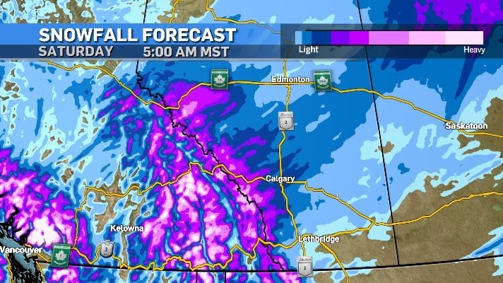
Given the ample supply of Pacific moisture, snow will eventually fall across southern Alberta and southern British Columbia, and given the right circumstances, will sit overtop of a layer of ice making traction especially difficult.

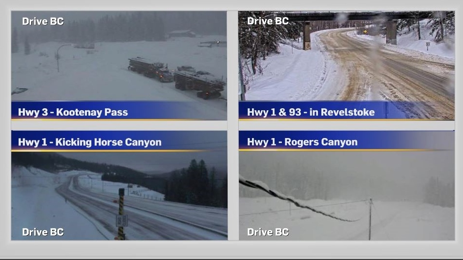
As of 7:30 a.m. Thursday, highways along the Alberta-BC corridor were showing accumulation on Drive BC cameras, with another five to 10 centimetres forecast for the mountain parks. Strong winds will continue to create visibility challenges due to blowing snow and icy surfaces along higher elevation and open roadways over the next 24 hours.

Environment and Climate Change Canada (ECCC) issued snowfall warnings, rainfall warnings and winter storm warnings for the mountain passes and foothills including Kananaskis and Canmore.
As of 8:30 a.m. Thursday those warnings were still in place but did not extend as far west as Calgary. Heavy snowfall and the potential for freezing rain could prompt additional warnings east of the foothills over the next 24 hours as the moisture tracks east.
Temperature-wise, Calgary will end up trapped under the sinking polar vortex until at least the middle of next week, starting with another big swing in temperatures from Thursday to Friday.

For the latest weather warnings from ECCC click here. Updated road conditions from 511 Alberta can be found here. And click here for highway conditions from Drive BC.
CTVNews.ca Top Stories

Celine Dion delivers stirring comeback performance at Paris Olympics opening ceremony
Against the rainy Paris night sky, Celine Dion staged the comeback of her career with a powerful performance from the Eiffel Tower to open the Olympic Games.
Jasper wildfire: 'Several weeks' before residents can return, premier says
Premier Danielle Smith said Friday afternoon in Hinton while weather conditions are cooler, the Jasper fire is still considered out of control and that Jasper residents can expect to be away from their homes 'for several weeks.'
Missing 3-year-old boy found dead in creek in Mississauga: police
A three-year-old boy has been found dead a day after he went missing in a park in Mississauga, Peel police say.
Irish museum pulls Sinead O'Connor waxwork after just one day due to backlash
An Irish museum will withdraw a waxwork of singer-songwriter Sinéad O'Connor just one day after installing it, following a backlash from her family and the public, it told CNN in a statement on Friday.
Winnipeg senior's account overdrawn for $146,000 water bill
A Winnipeg senior is getting soaked with a six-figure water bill.
Turpel-Lafond won't sue CBC over Cree heritage report that took 'heavy toll': lawyer
The lawyer for a former judge whose claims to be Cree were questioned in a CBC investigation says his client is not considering legal action against the broadcaster after the Law Society of British Columbia this week backed her claims of Indigenous heritage.
Driver charged after flashing high beams at approaching police
Orillia OPP arrested and charged a driver with impaired driving after flashing their high beams.
Major Canadian bank experiences direct deposit outage on payday
Scotiabank says it has fixed a technical issue that impacted direct deposits on Friday morning.
Health Canada warns some naloxone kits contain false instructions
Health Canada is warning some take-home naloxone kits come with bad instructions that should be ignored in favour of the correct guidance.


