More storms possible Wednesday with a warm up to kick off Stampede

The synoptic setup in southern Alberta Wednesday is similar to the one yesterday.
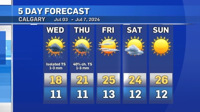
Instability remains prevalent with embedded storms in an upper level trough likely to bring some convective activity (thunderstorms) Wednesday afternoon and evening.
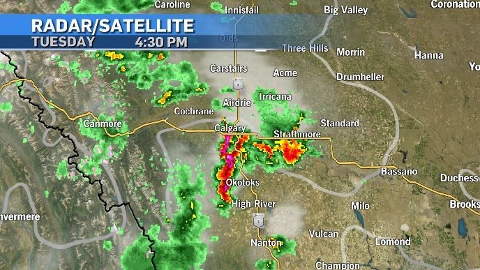
On Tuesday, rapid intensification over the City of Calgary in the early afternoon produced a line of thunderstorms which prompted severe thunderstorm warnings.
Intense rain and the accumulation of hail causing flash flooding across the city that continued through the afternoon commute.
An incoming ridge of high pressure from the Pacific northwest will help reset the weather pattern, bringing a west-to-east flow and driving up temperatures.
As that ridge encounters the remnants of the cooler air on Thursday, more thunderstorms are possible – but these storms on Thursday will fire off the foothills rather than slide in from the north like the ones over the past couple of days.
Storms are likely to continue into the overnight hours early Friday, but weather for the Calgary Stampede parade on Friday morning should be dry as showers track east.
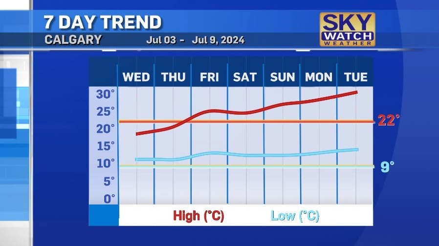
Both daytime highs and overnight lows are expected to hold above seasonal until at least the middle of next week.


CTVNews.ca Top Stories

'I got no remorse': Greg Fertuck, convicted of murdering missing spouse, sentenced to life in prison
Greg Fertuck will spend life behind bars with no chance of parole until he is 90 years old, a judge ruled on Thursday at Saskatoon's Court of King's Bench.
'Ford's dry summer begins': All LCBO stores closed as workers go on strike
All LCBO stores are closed on Friday as thousands of workers hit the picket lines after their union and employer failed to reach an agreement.
Britain's Labour on track for landslide victory, exit poll suggests, amid anger with Conservatives
Britain's Labour Party headed for a landslide victory Friday in a parliamentary election, an exit poll suggested, as voters punished the governing Conservatives after 14 years of economic and political upheaval.
Saskatchewan has the lowest hourly minimum wage. How does it stack up to the rest of Canada?
Hourly minimum wages increased in several Canadian provinces this spring with more on the horizon, which economists say will likely impact workers and businesses differently.
Trying to sell or buy a home this summer? What a realtor says you should know
In the first few weeks of summer, the real estate sector is experiencing an upturn marked by more housing inventory, a Canadian realtor says
No Frills grocery stores drop 'multi-buy' offer
As receipts tick ever higher for Canadians at the grocery store and shoppers continue to search for savings, one Canadian grocer has ended a perceived deal.
Hurricane Beryl churns toward Mexico after leaving destruction in Jamaica and eastern Caribbean
After leaving a trail of destruction across the eastern Caribbean and at least nine people dead, Hurricane Beryl weakened as it chugged over open water toward Mexico's Yucatan Peninsula on Thursday, going from the earliest Category 5 hurricane in the Atlantic to Category 2 by the afternoon.
CSIS director David Vigneault stepping down after seven years on the job
David Vigneault says he is stepping down from his job at the head of Canada’s spy agency. The director of the Canadian Security Intelligence Service, who spent seven years at the helm, is leaving the public service altogether.
Biden tells Democratic governors he needs more sleep and plans to stop scheduling events after 8 p.m.
U.S. President Joe Biden told Democratic governors during a meeting at the White House on Wednesday that part of his plan going forward is to stop scheduling events after 8 p.m. so that he can get more sleep, according to three sources briefed on his comments.
Shopping Trends
The Shopping Trends team is independent of the journalists at CTV News. We may earn a commission when you use our links to shop. Read about us.


Edmonton
-

Two firms offering auto insurance to pull out of Alberta market
Two insurance providers in Alberta have announced plans to stop offering automobile insurance to customers in the province.
-
'He wants to fight': Edmonton family left waiting months for cancer treatment as condition worsens
An Edmonton woman says she's losing hope as her husband has been left waiting for months to see an oncologist after being diagnosed with Stage 4 cancer this spring.
-
Police seek potential witnesses to Mill Creek Ravine homicide
Edmonton police are releasing photos of a vehicle whose occupants they believe may have seen activity related to a recent homicide in the Mill Creek Ravine.
Lethbridge
-

2024 Southern Alberta Summer Games kick off in Coaldale
Nearly 2,000 athletes will compete in 20 events over four days during the 2024 Southern Alberta Sumer Games. After months of planning, organizers are thrilled to welcome families from all over southern Alberta to Coaldale, Alta.
-
Court hears accused in Coutts blockade thought protest could lead to 'war'
One of two men accused of conspiring to kill Mounties at the border blockade at Coutts, Alta., characterized the protest as a last stand and told his mother there “will be a war” if police moved in.
-
Fire ban ended for Lethbridge area
With the recent moisture and cooler temperatures, fire bans and restrictions in the Lethbridge area are no longer in effect.
Vancouver
-

Widower living with toddler at B.C. rest stop desperate for housing
A father living in an RV in B.C.’s Fraser Valley with his toddler for more than a year has become even more desperate to find housing after facing a tragic loss.
-
'Extremely apologetic': Abbotsford fire chief sorry for foam spilled in creek
Cleanup is underway in Abbotsford after spilled firefighting foam ended up in a local creek Wednesday night.
-
Vancouver considers putting housing before mountain views
Vancouver’s magnificent mountain vistas will be front and centre at city hall next week, when councillors will debate whether to ease view protection rules to make room for more construction.
Vancouver Island
-

Police seize 20 guns, thousands of bullets, 4.5 kg of cocaine from Greater Victoria home
A Greater Victoria man has been arrested and released from custody after police seized several guns, thousands of rounds of ammunition and four and a half kilograms of cocaine from a home in Langford, B.C., last week.
-
B.C. COVID hospitalizations at highest level since January
It may not be on most people's minds, but COVID-19 is on the rise again in B.C.
-
Cluster of earthquakes off B.C. coast 'business as usual,' seismologist says
A British Columbia seismologist says there's nothing dangerous or unusual about a recent flurry of earthquake activity off the west coast of Vancouver Island.
Saskatoon
-
'I got no remorse': Greg Fertuck, convicted of murdering missing spouse, sentenced to life in prison
Greg Fertuck will spend life behind bars with no chance of parole until he is 90 years old, a judge ruled on Thursday at Saskatoon's Court of King's Bench.
-
Saskatoon man survives three-storey fall from downtown building
A Saskatoon man is recovering in hospital after falling three storeys off the roof of a downtown building on Canada Day.
-
Saskatoon city councillor's leadership at private Christian school revealed in leaked document
A leaked document reveals a Saskatoon city councillor's involvement at a private Christian school embroiled in abuse allegations.
Regina
-

Sask. files injunction in light of federal carbon tax dispute
The Government of Saskatchewan has filed an injunction in light of the federal government sending the Canada Revenue Agency (CRA) after the province’s bank account, Premier Scott Moe said on Thursday.
-
Crop development in Sask. falls behind due to recent rainfall
Because of heavy rain and cooler conditions in parts of the province, crop development is falling behind normal for this time of year.
-
Star Blanket Cree Nation celebrates the opening of a new water treatment plant
A water treatment plant nearly a decade in the making is now up and running on the Star Blanket Cree Nation.
Toronto
-

'Ford's dry summer begins': All LCBO stores closed as workers go on strike
All LCBO stores are closed on Friday as thousands of workers hit the picket lines after their union and employer failed to reach an agreement.
-
What you need to know as LCBO workers go on strike
All LCBO stores across the province are closed for two weeks starting Friday as workers go on strike for the first time after their union and employer failed to reach an agreement.
-
Two Toronto councillors propose action plan to tackle increasing rat infestations
Two Toronto city councillors are asking staff to develop a rats reduction strategy by the latter half of next year to deal with infestations, but some say the problem needs immediate action.
Montreal
-

Fire department says inspectors were refused access to do safety check at McGill pro-Palestinian encampment
The Montreal fire service said its inspectors were refused access to do a safety check at the pro-Palestinian encampment at McGill University on Thursday.
-
Man in critical condition after being attacked in Montreal's Plateau, police investigating
Montreal police are investigating after a man was attacked with a blunt object in an alley near the Mont-Royal metro station in the Plateau.
-
Quebec asks Supreme Court judge to recuse himself on Bill 21 case
In the wake of the legal challenge to Bill 21 on the secular nature of the State, Quebec Attorney General Simon Jolin-Barrette has asked Supreme Court Justice Mahmud Jamal to recuse himself, fearing that he "does not have the impartiality required to hear this case."
Atlantic
-

'Shelter in place' order lifted in Fredericton, man arrested
A shelter in place order issued in Fredericton Thursday has been lifted.
-
Possible shark sighting temporarily closes popular Maritime beach
A suspected shark sighting caused a popular Nova Scotia beach to close temporarily Thursday.
-
Portuguese man o' war seen on coastal beaches: Nova Scotia Parks
Nova Scotia Parks says Portuguese man o' war have been spotted on Atlantic coastal beaches recently.
Winnipeg
-

Aging, degrading Manitoba Hydro infrastructure could cost billions to upgrade
Manitoba Hydro may needs billions of dollars worth of upgrades for aging infrastructure.
-
Manitoba First Nation identifies missing fishers
The search continues for two missing fishers who never returned home from a hunting trip.
-
West St. Paul home a total loss after massive fire
A West St. Paul home is a total loss after it went up in flames Thursday.
Ottawa
-

'Ford's dry summer begins': All LCBO stores closed as workers go on strike
All LCBO stores are closed on Friday as thousands of workers hit the picket lines after their union and employer failed to reach an agreement.
-
Patricia Boal named anchor of CTV News at Six
Veteran broadcaster Patricia Boal has been named anchor of CTV News at Six, CTV News Ottawa announced Thursday.
-
Almonte hospital experiencing shortage of radiologists
The Almonte General Hospital is reportedly experiencing another loss of services.
Northern Ontario
-

Full fuel tank was dangling from transport on Hwy. 17, northern Ont. police say
The driver of a commercial motor vehicle has been charged after police noticed something dangling underneath the vehicle.
-
Drug trafficking suspects charged with armed home invasion in Sudbury
One suspect from Sudbury and two from southern Ontario have been charged after a group of masked people broke into a home on Colonial Court early Wednesday morning.
-
'Ford's dry summer begins': All LCBO stores closed as workers go on strike
All LCBO stores are closed on Friday as thousands of workers hit the picket lines after their union and employer failed to reach an agreement.
Barrie
-

Bracebridge considers pulling back $10 million hospital funding commitment
The Town of Bracebridge is second-guessing its $10 million funding commitment to Muskoka Algonquin Healthcare (MAHC) after its board voted to proceed with its controversial two-hospital redevelopment proposal.
-
Driver injured in tractor-trailer rollover on ramp to Highway 400
One person is in the hospital following a tractor-trailer rollover on a ramp to Highway 400 late Thursday afternoon.
-
New details released after body found near Highway 400 ramp in Barrie
Police say the death of a man found in a grassy area near a Highway 400 ramp in Barrie late last month is not considered suspicious.
Kitchener
-

WWE superstar surprises Guelph, Ont. fan who didn’t have accessible seat
A wrestling fan from Guelph, Ont. thought he was down for the count after winning tickets to a “once-in-a-lifetime” WWE event in Toronto.
-
'Ford's dry summer begins': All LCBO stores closed as workers go on strike
All LCBO stores are closed on Friday as thousands of workers hit the picket lines after their union and employer failed to reach an agreement.
-
Cambridge senior living in flood-damaged apartment gets help from Good Samaritan
A Good Samaritan is stepping up to help a senior after his Cambridge apartment flooded, destroying most of his belongings.
London
-
'Ford's dry summer begins': All LCBO stores closed as workers go on strike
All LCBO stores are closed on Friday as thousands of workers hit the picket lines after their union and employer failed to reach an agreement.
-
Why does the new Victoria Bridge look like that?
On Thursday, over a hundred Londoners attended a ‘bridge party’ to celebrate completion of the new span over the Thames River connecting the Old South neighbourhood to the downtown.
-
Murder involving two youths shocks Huron County community
A tight-knit Huron County community remains in disbelief after learning a 13-year-old local boy has been charged with first-degree murder. The age of the accused, confirmed by the court, has sent shockwaves through the village of Holmesville.
Windsor
-
'Ford's dry summer begins': All LCBO stores closed as workers go on strike
All LCBO stores are closed on Friday as thousands of workers hit the picket lines after their union and employer failed to reach an agreement.
-
'Frustration at the ultimate level': Riverside couple to uproot landscaping following 50 complaints from one resident
Disappointment lingers over the property of a Riverside couple that was told to remove landscaping from their front lawn after a resident complained that it doesn’t conform to the city’s public right-of-way encroachment bylaws.
-
Chatham-Kent Barnstormers hit the ground running in debut season
The Chatham-Kent Barnstormers have been swinging for the fences in their debut season – and the community appears to be behind them.


