Snow on the way – but how much reaches Calgary?
AFTERNOON UPDATE: So far, our speculation is on the right track.
Of note; there are a pair of other models projecting for over ten centimetres. I'm not completely discounting that... but the pattern is still looking more likely that the system bypasses us for the heaviest snow.
There are few other changes to our temperature and condition outlooks. A few more overnights will reach the freezing mark. That's the extent!
MORNING EDITION: That was quite the run we had.
From yesterday’s data, we were just shy of eight degrees above our seasonal normal for the first 19 days of October (seasonal average being near 13 C, actual being 20.6 C so far).
The scales likely won’t fully balance for the last eleven days of the month; for that to happen, we’d need average highs I don’t much want to think about.
Today, we’ll experience a series of northerly gusts to kick things off, and from there, the cozy knits and thicker jackets replace the T-shirts and flip flops for the foreseeable future.
Calgary’s snowfall total is the ongoing, somewhat-unknown element at this time. Some models show a half a foot of snow; some that show flurries. So which one’s right?
Here’s the breakdown.
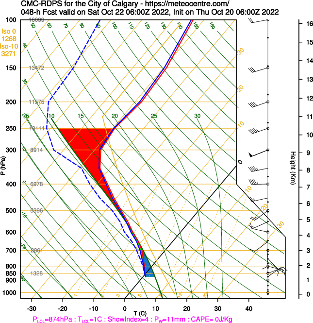
Albertans know that systems crossing those pesky Rockies have a lot of variability to them; we don’t have modeling technology that tracks it well. Looking for correlations across different models can be helpful; and so can soundings, like the one below from Meteocentre:

(Skip the science to the next paragraph, as you please!) The red and blue lines on here are our temperature and dewpoint temperature lines. Them being bound together through the mid-layer of our atmosphere (the ‘500’ in black on the left side of the chart) in a freezing environment means we’re looking at snow. However, our surface temperature likely doesn’t support that snow sticking around, at least at first; snowflakes hitting surfaces don’t like positive temperatures all that much.
At this time, we’re likely facing those big, wet, dense snowflakes. They’ll fall at a decent rate through the late hours, and then we have two scenarios:
- The way this storm tilts as it crosses the Rockies pushes a layer in that coats the grass and makes the roads a wet mess
- The storm tilts even heavier and we get a full coat, making the roads a wet mess
…you may notice some common ground there. Wet snow usually has a lesser accumulation because it’s denser and sits heavier. If I’m pressed into making a call on the snowfall total, my lean at this time is between two and four centimetres; the isolated models with a double-digit snowfall total require a very specific track for this system that causes it to sustain through the majority of the day, and I’m not sold on it yet.
Oh, and the rest of the forecast is cool and drab. See below and stay safe out there. Dare I say… stay frosty?
Your five day forecast:
Thursday
- Evening: mainly clear, low 3 C
Friday
- Mainly cloudy, scattered showers
- Daytime high: 9 C
- Evening: mostly cloudy, overnight showers becoming snow showers, low 0 C
Saturday
- Snow showers; mainly cloudy; 2-4 cm
- Daytime high: 3 C
- Evening: chance of mixed precipitation, low -1 C
Sunday
- Partly cloudy
- Daytime high: 4 C
- Evening: some cloud, low 0 C
Monday
- Partly cloudy
- Daytime high: 10 C
- Evening: some cloud, low 1 C
Tuesday
- Mainly sunny
- Daytime high: 9 C
- Evening: some cloud, low -1 C
Submit your weather photos here to see them featured in our article, and perhaps even as the pic of the day during our news at six. You can also share to my Facebook page, on Twitter, or to our Instagram at @CTVCalgaryWeather.
CTVNews.ca Top Stories

Tensions flare between Poilievre and Singh in the House after NDP says it will back Trudeau Liberals
Conservative Leader Pierre Poilievre and NDP Leader Jagmeet Singh got into a heated exchange in the House of Commons on Thursday, just minutes after Singh announced his party would not be supporting the Conservatives' first non-confidence motion against Prime Minister Justin Trudeau's government.
'It's disgusting': Quebec minister reacts after body of boy, 14, found near Hells Angels hideout
The province's public security minister said he was "shocked" Thursday amid reports that a body believed to be that of a 14-year-old boy was found this week near a Hells Angels hideout near Quebec City.
Missing six-year-old boy disappeared after school breakfast program: Manitoba RCMP
Shamattawa RCMP are searching for a missing six-year-old boy who hasn’t been seen since Wednesday morning.
Woman dead, toddler uninjured following B.C. police shooting, watchdog says
B.C.'s police watchdog is investigating the death of a woman who was shot by the RCMP after allegedly barricading herself in a room with a toddler early Thursday morning.
PM Trudeau names Anita Anand transport minister after Pablo Rodriguez quits cabinet
Prime Minister Justin Trudeau tapped Treasury Board President Anita Anand to take on additional duties as Canada's minister of transport on Thursday.
Canadian women among those who allege Harrods boss sexually abused them
CTV News has learned there are multiple Canadian women alleging they were victims of sexual abuse at the hands of the late Harrods boss Mohamed Al Fayed.
The Royal Canadian Mounted Police has lost 205 firearms since 2020, including machine-guns
The Royal Canadian Mounted Police has lost 205 firearms since 2020, including more than 120 handguns and at least five fully automatic weapons like machine-guns.
Shohei Ohtani becomes the first major league player with 50 homers, 50 stolen bases in a season
Shohei Ohtani became the first major league player to hit 50 home runs and steal 50 bases in a season, with the Los Angeles Dodgers star going deep twice to reach the half-century mark and swiping two bags to get to 51 against the Miami Marlins on Thursday.
Francois Legault wants the Trudeau government to fall
Quebec Premier Francois Legault is calling on the Bloc Quebecois to topple the Trudeau government next Wednesday and trigger a federal election.


